The Setting
Only with the advance of climatic management has architecture been provided the means to distance itself from its immediate environment. For centuries prior to our own, building reflected the impact of the elements on its form, engaging in an exchange between the forces of nature and those of artifice. The needs of individuals and societies also tempered the contour of architecture as habitation acquired concrete form. In time, an architecture balancing these imperatives resulted; in New Mexico the process was no different.
The landscape of New Mexico can stagger with its endlessness [Plate 1]. The land cannot be described as lush in any but a few isolated valleys, and at times desolate is a more appropriate adjective. But even amid the aridity and sparse vegetation there is always the promise of beauty to come: for example, when the cottonwoods are in autumn color or the desert flowers in spring bloom. But the land and the vegetation are only the raw ingredients of New Mexico's landscape. To them must be added
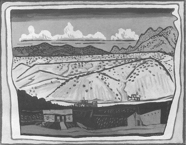
1–1
New Mexican Landscape
Stuart Davis
1923
[Amon Carter Museum, Fort Worth, Texas]
the desert light. "The high desert plain is a land where distance is lost, and the eye is a liar, a land of ineffable lights and sudden shadows; of polytheism and superstition, where the rattlesnake is a demigod," as Charles Lummis waxed poetically.[1] The chroma of grays, browns, reds, and even blacks of the earth and stone constantly change as the hot, unrelenting light of noon passes into the oblique shadows of approaching sunset. From spring to fall, the sky can be a piercingly clear blue unhampered by reflective dust or refractive moisture. The thunderstorms of summer create fluid skies that layer cloud on cloud, gray on gray continually dissolving like ink on water. Only in winter, when storm clouds obscure the sun, is the bowl of the sky lowered onto the land.
In Sky Determines , Ross Calvin proposed that the aridity of the land endowed the state with its particular character. From the sun, from the desert, came the vegetation and, later, the architecture. Although Calvin's thesis may be too rigidly deterministic, its basic premise is plausible. Nevertheless, the availability of water was only one of the major factors that affected settlement; other environmental conditions also influenced the form that human presence took on the land.
New Mexico occupies a plateau high in elevation, with Santa Fe, the capital, located in the state's northeastern quadrant [Plate 2]. Its ecology is classified as High Sonoran Desert: low in humidity despite the altitude. Elevations above six thousand feet enjoy an annual precipitation of about fourteen inches, a radical contrast to the three inches or less that water the deserts below. The plateau falls sharply just north of the small town of La Bajada (about twenty-five miles south of Santa Fe), and at the foot of this drop lies the pueblo of Cochiti, set against the clearly visible strata of black volcanic rock. Further south, the plain descends an additional several hundred feet as it slopes gradually to Albuquerque and beyond to Las Cruces on the Mexican border.
Cutting across New Mexico from roughly north to south are great ranges of mountains bracketing the fertile river valleys that have sustained both indigenous and colonial settlements. A somewhat milder extension of the Rocky Mountains, the Sangre de Cristo (Blood of Christ) Mountains lie to the east of Santa Fe, isolating the eastern plains from the Rio Grande drainage and peaking at roughly thirteen thousand feet above sea level. The two major gaps in these mountains—the Raton and Glorieta passes—have been strategically important throughout history.
To the northwest of Santa Fe lie the Jemez Mountains, geologic survivors of a massive prehistoric volcanic explosion. The meadows and farms within its caldera contrast sharply with the colors of the desert that surrounds it four thousand feet below. Steep and pine-forested, the source of streams and rivers that eventually drain into the Rio Grande, these mountains form the backdrop to the pueblos of Jemez, Zia, and Santa Ana. The mountains are home to the piñon pine (source of pine nuts) and the scrubby juniper, which rarely grows higher than fifteen feet or so and whose twisted configuration yields little usable wood for major construction. The mountains also provide the tall and straight ponderosa pine used for roof beams, and thus to the mountains the builders went, no matter the distance or the difficulty in transporting the huge logs once they were cut.
Albuquerque is dominated by the hulking backdrop of the Sandia Crest, whose round contour terminates the view of the city when it is approached from the west. Further south the Manzano Mountains turn slightly to the southeast, demarcating the Salinas district, whose dried lakes provided the precious commodity of salt for domestic use and trade. The Salinas district was the site of the missions of Abo, Quarai, and Gran Quivira, known in combination with several smaller settlements—more poetically than accurately—as the "Cities That Died of Fear."[2] The Jicarilla Range beyond marks the southernmost boundary of colonial church building from the beginning of the Spanish settlement to the end of the seventeenth century.
The longest and the largest river in New Mexico, the Rio Grande del Norte is the aorta of the New Mexican landscape [Plate 3]. When the Spanish came upon this river as they moved east from Zuñi, they were aware neither of its source in the mountains of southern Colorado nor of its extent. Broad, yet shallow in its southern parts, the river's majesty increases in the north, culminating in the great Rio Grande gorge south of Taos. Here the deep cut and swiftness of the current suggest the sleeping giant capable of eroding banks and destroying villages. (The river swept away the Santo Domingo church in 1886.) Although always a river of intermittent flow—full and swift during the spring thaw, slow and gentle in late summer—its dimensions today are no longer what they were in the past. Modern water-management systems have significantly modified the Rio Grande: the dam above Cochiti, for example, has reduced the river to a stream during certain times of the year, affecting life along its length. A number of major tributaries feed the river, and
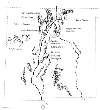
1–2
Landforms
[Adapted from Beck and Haase, Historical Atlas of New Mexico ]
these, too, have fostered settlement. To the north the Chama River provides water to the villages around Abiquiu. Rivers flowing from the Truchas Peak and other nearby mountains sustain the fertile valleys that support the villages of Las Trampas, Chimayo, Cordova, and Santa Cruz. Further south the Jemez drainage serves the pueblos of Jemez, Zia, and Santa Ana before its rivers and streams empty into the Rio Grande.
Roughly paralleling the Rio Grande is the Pecos River drainage, the second major valley system to the east. Here the mountains join the plains, and the sedentary Pueblo Indians were forced to confront the nomadic Plains Indians tribes that included, in time, the Comanche and the Apache. To the west of Albuquerque stretch hundreds of miles of deserts and mesas, a dry landscape of flat-topped landforms that provide the background for the pueblos of Laguna, the Sky City of Acoma, and the Zuñi pueblos near the Arizona state line.
Topography and climate were not the sole determinants of architectural form in New Mexico. They were but two, albeit important ones, of a constellation of factors that included defense, available building materials and technology, and social practices.