Spanish Town Planning
At the time of the initial Spanish entrada into New Mexico, the Pueblo Indians already occupied most of the rich river drainage lands, such as the Rio Grande and the basins of the Chama, Pecos, and Galisteo rivers, which were fertile with organic matter eroded by the rivers near their origins and redeposited along their banks. The rivers also guaranteed the steady supply of water necessary to make the land viable. Because the Europeans shared with the Pueblo Indians a need for productive soil, Spanish colonies often overlaid native settlements, forcing the indigenous peoples to shift location by pushing them on or by circumscribing the lands surrounding the pueblos. Although a proscription against this kind of incursion was included in the Royal Ordinances on Colonization (the king declared his concern for the well-being of all his citizens, including those of non-Hispanic origin), disputes arose constantly as the fight over arable land continued without conclusive resolution.
Defense against a mutual enemy, the Plains Indians, encouraged an uneasy alliance between the Spanish and the Pueblo tribes. Unlike the Pueblo peoples, Hispanic settlers displayed a distinct preference for living next to their fields in scattered ranches, even though this left them particularly vulnerable to Apache, Comanche, or Navajo attack. When danger threatened, they were forced to flee or to live within the pueblo until the threat subsided. While uncomfortable with the alien presence, the Pueblo peoples were at least grudgingly grateful for the security offered by European arms. In any event, they were offered very little choice in the matter.
To withstand the hit-and-run tactics of Indian incursions, settlements were developed on the model of the plaza , a word that can be loosely translated in English as "fortified village."[34] Consisting of a continuous perimeter of thick-walled adobe buildings, the plaza presented an almost unbroken exterior surface. At Las Trampas and Ranchos de Taos, vestiges of the plaza remain and suggest that the church was built pragmatically as a part of the circumferential wall to reduce the total volume of construction. The best-preserved example of the type is found at the Plaza del Cerro at Chimayo (founded about 1730, heavily restored in this century) northeast of Española. Here the structures for dwelling
1–9
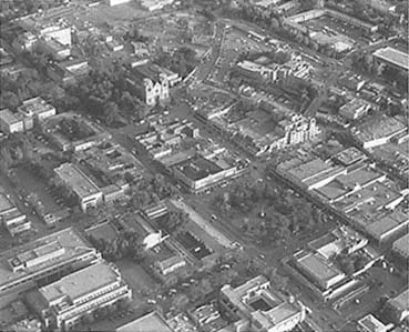
Central Santa Fe
The plaza occupies the area in the center of the photo; the Cathedral
of Saint Francis is above and to the left; the Palace of the Governors
lies to the lower left.
[Paul Logsdon, 1980s]
and utility adjoin along the perimeter, and almost all of them, even today, expose few openings to the countryside. The enclosed land offered limited areas for gardening and grazing, a problem aggravated by the limited availability of water to those who sought refuge within the walls of the plaza during times of threat. The plan of the plaza as a whole was more important than any single building, and there was little adjustment of building form for any particular use. (On the west side of the plaza, for example, the small private Ortega chapel of San Buenaventura is distinguished from the houses and utility structures of the plaza only by a cross and a small wooden turret on its roof.) The plaza was a more generic and less formally conceived type of town layout. The only true architecturally planned communities in New Mexico were the villas , or chartered municipalities, the foremost settlements in the territory.
In 1599–1600 the Spanish moved into the town of Yunque (also Yungue or Yunge) on the bank of the Rio Grande and established the first de facto capital of New Mexico at San Gabriel.[35] Lying far to the north, San Gabriel was soon deemed to be an ineffective administrative center because the Rio Grande pueblos extended from Taos in the north to near Socorro in the south, with spurs to the southeastern Salinas district and westward to Acoma and Zuñi. The capital was relocated for expediency in 1610 to what is now Santa Fe. Although not directly on the Rio Grande—which was a distinct disadvantage for agriculture—the site was otherwise well suited for settlement. Its average rainfall far exceeded that of the lower elevations, and the new site was more centrally located in relation to the string of native communities along the river.
As early as 1513 various ordinances governing a wide range of details regarding colonization had been issued; these were formalized by Philip II in 1573 as the Laws of the Indies. Although they were intended to cover virtually every aspect of colonization, the impact of these directives diminished with distance from Mexico City, and in New Mexico their dicta were often only weakly applied. Santa Fe, however, remains one of the few cities in the United States that clearly bear the stamp of these codes even today. The city, as envisioned in the Laws of the Indies, was to be rational in design and yet possess and express symbolic and ceremonial attributes. The conception of urban form embodied in the articles was derived from Renaissance humanism and was a response to the medieval city's dual problems of crowding and civil strife, both the results of uncontrolled and convoluted incremental
growth. To some degree the prescribed city plans were based on cross-axial grids similar to those of the Roman city, with its cardo (north-south) and decumanus (east-west) streets. Each subsequent revision of the planning ordinances after 1513 more closely emulated the rectilinearity, if not the precise layout, of the Roman model.[36] Also, the reintroduction of the grid in Spanish Renaissance thought probably revealed the influence of the architect and theorist Leon Battista Alberti's noted architectural treatise De re aedificatoria (Ten Books on Architecture, 1485 or 1486), which circulated widely in learned circles. Alberti, in turn, had drawn on the Roman Vitruvius, an architect who also influenced sixteenth-century Mexican architecture, as a major source of information and inspiration.[37]
Although Renaissance humanism is usually identified as the motivating force for the use of the grid plan throughout Spanish America, a direct connection with European practice has been lacking, even though the bastides of southern France and siege towns in Spain were both planned on the grid system and resembled settlements built in accord with the Laws of the Indies. George Kubler recently demonstrated, however, that towns constructed in France between Grasse and Nice to repopulate the countryside during the early sixteenth century were just such a connection. Previously abandoned during the plague years of the fourteenth century, new towns such as Valbonne (1509) and Vallauris (1501)—both of which were developed by the Benedictine abbey of Saint Honorat of Lérins—were planned without walls but with contiguous dwellings forming a defined perimeter. Valbonne in particular resembles an enlarged version of a New Mexican fortified village such as Chimayo, subdivided using an orthogonal geometry with the plaza near its center.[38]
The Laws of the Indies also prescribed the location and site of the town by, for example, specifying on which shore of a river the city should be built for defense or commerce and how to ascertain the quality of the land:
The health of the area which will be known from the abundance of old men or of young men of good complexion, natural fitness and color, and without illness; and in the abundance of healthy animals of sufficient size, and of healthy fruits and fields where no toxic and noxious things are grown, but that it be of good climate, the sky clear and benign, the air pure and soft, without impediment or alterations and of good temperature, without excessive heat or cold, and having to decide, it is better that it be cold.[39]
Colonists were urged to settle "in fertile areas with
1–10
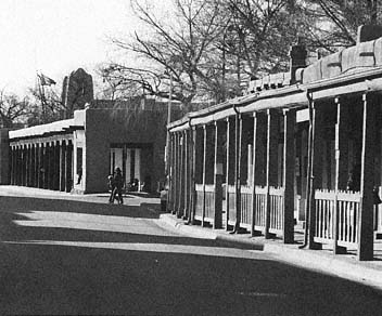
East Palace Street
Santa Fe
The arcades of Sena Plaza and the Palace of the Governors suggest
the character of the capital's streets during the late nineteenth
century.
[1981]
an abundance of fruits and fields, of good land to plant and harvest, of grasslands to grow livestock, of mountains and forests of wood and building materials for homes and edifices, and of good and plentiful water supply for drinking and irrigation."[40]
The ceremonial heart of the town was the plaza mayor , the principal open space. Less a square or a promenade than a campus martius on which the military could train and parade, the main plaza was "to be the starting point for the town. . . . The Plaza should be square or rectangular, in which case it should have at least one and one half times its width for length inasmuch as this shape is best for fiestas in which horses are used and for any other fiesta that should be held."[41] Moreover, "the size of the plaza shall be proportioned to the number of inhabitants. [The plaza] shall be not less than two hundred feet wide and three hundred feet long and five hundred and thirty-two feet wide. A good proportion is six hundred feet long and four hundred wide."[42] Fronting the north side of the plaza was the Palacio Real, or Palace of the Governors, a site the building still occupies in Santa Fe.[43]
Curiously, the principal religious edifice was to be built, not squarely on the main plaza, but to one side—apparently to provide greater prominence. "The temple in inland places shall not be placed on the square but at a distance and shall be separated from any other building or from adjoining buildings; and ought to be seen from all sides so it can be decorated better, thus acquiring more authority."[44] "For temples of the principal church, parish, or monastery, there shall be assigned specific lots. . . . These shall be a complete block so as to avoid having other buildings nearby."[45] The predecessor of today's Cathedral of Saint Francis in Santa Fe, the Parroquia (parish church) occupied a site in accord with this directive. It should be noted, however, that the plaza originally encompassed twice its current area and that the block today bounded by East Palace Avenue, Federal Drive, and East San Francisco Street was originally part of the plaza before it was displaced by commercial construction during the nineteenth century.[46]
The cathedral thus originally occupied a position of only secondary importance on one corner of the plaza. Prominence and centrality were instead granted to the Palace of the Governors, the administrative center and residence of the king's representative in the colony. Although the relative position of church and state on the plaza of Santa Fe might strike us today as curious, the urban form embodied implicit attitudes about their respective positions in the provincial capital. In spite of the tone and intermittent specificity of the planning ordinances, they were ultimately ambiguous and open to interpretation, and their literal application was only very rarely the case in New Mexico.
Extending from the political, social, and commercial heart of the town were streets arranged in a rectangular grid. Article 114 proclaimed that "from the plaza shall begin four principal streets," and Article 115 announced that "around the plaza as well as along the four principal streets which begin there, there shall be arcades, for these are of considerable convenience to the merchants who generally gather there." Indeed, native merchants continue to trade in the arcade of the Palace of the Governors in Santa Fe today. The Laws of the Indies also described other characteristics of the ideal city and warned that unhealthy but necessary services, such as fisheries, slaughterhouses, and tanneries, should be positioned so "that the filth can be easily disposed of."[47] The town should have a commons, and sites for houses and shops were to be distributed by lottery, although no lots on the plaza were to be given to "private individuals."[48] Once assigned, the inhabitants were admonished that "each house in particular shall be built that they may keep therein their horses and work animals, and shall have yards and corrals as large as possible for health and cleanliness."[49] In spite of the careful planning of the city and in spite of its status as provincial capital, Santa Fe was characterized in the late eighteenth century by Domínguez as "lack[ing] everything. . . . The Villa of Santa Fe (for the most part) consists of many scattered ranchos at various distances from one another, with no plan to their location."[50]
After the Reconquest of 1692–1693, Governor Vargas was forced to find new land to accommodate sixty-six families that had recently emigrated to northern New Mexico. One must assume, however, that the limited tracts of arable land surrounding the capital, rather than any actual dearth of building sites, caused the founding or refounding of the second villa, Santa Cruz. Reduced today to a dusty field of intersecting roads, Santa Cruz retains even less of its original plaza than does Santa Fe. Perhaps buildings never fully enclosed the space, although an 1848 sketch plan suggests a dense, contiguous architectural fabric. The definition of the plaza in an architectonic sense is minimal, and to the great bulk of the church of Santa Cruz falls the task of marking the center of a densely built town that no longer exists.
The third of the charted municipalities, Albuquerque, was founded in 1706 and still possesses a neat plaza whose style, like that of the church of
1–11
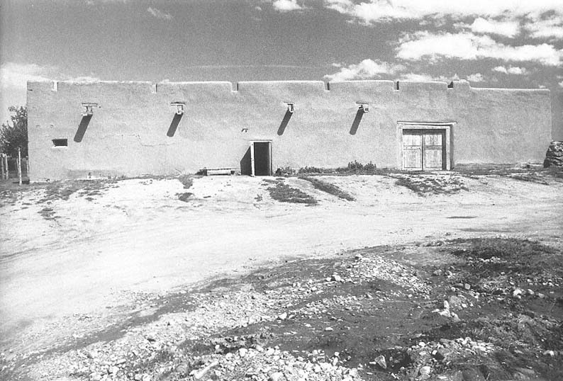
Severino Martínez House
Taos, circa 1804
The house as protection from the enemy and the elements, with stout adobe walls, few openings, and internal courtyards.
[1986]
1–12
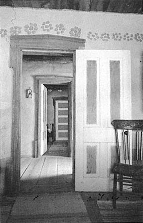
Farmhouse From Mora
Reerected at Las Golondrinas Folk Museum, La Cienaga
The interior of the house was developed as a linear
arrangement of rooms; the pedimented doorways and
painted wall decoration are characteristic of northern
New Mexico.
[1984]
San Felipe Neri on its north side, was anglicized late in the nineteenth century. The vast expansion of the city in the postwar years and the unfortunate development of Old Town Albuquerque as a tourist attraction during the last decade or two have undermined the calm dignity amid dust that characterized the earlier plazas. Beneath the surface, however, the skeleton of the original plaza and the diluted directives of the Laws of the Indies can still be ascertained.