2—
Geomorphology
Deborah L. Elliott-Fisk
Geomorphology is the scientific study of landforms. This discipline, which has traditionally been a part of both geography and geology, focuses on (1) describing the various landforms that make up the earth's natural landscape, (2) determining the processes that have shaped these landforms, and (3) reconstructing the environments in which these features formed. Because of its high diversity of bedrock types, large elevational gradient, and geologic history, the White-Inyo Range possesses a diverse suite of landforms.
What is a landform? It is simply a part of the landscape that has a distinctive shape or morphology, a unit that can be delineated either qualitatively by visual means in the field or quantitatively through an analysis of morphology, composition, and relative position on the landscape. Hills, valleys, mountain peaks, dunes, and floodplains are all landforms. Landforms in the White-Inyo Range are listed by their origin in Table 2.1.
It is easiest to think of a landform as being a function of process, materials, and time (Gregory, 1978). The three external processes shaping landforms are (1) weathering, (2) erosion, and (3) deposition. These three processes will each be discussed briefly.
Weathering
Weathering is the chemical decomposition and mechanical disintegration of rock materials. We can think of this as the wearing away of earth materials through time. Different weathering processes have relative degrees of importance in different environments and are partially functions of climate. Many mechanical weathering processes require temperature and moisture fluctuations. These changes exert a mechanical stress on the rock (such as frost wedging), which causes it to disintegrate along joint planes or between individual mineral grains (Fig. 2.1). Chemical weathering, like all chemical processes, is a function of temperature. With the presence of water, at higher temperatures chemical weathering will take place more rapidly.
Thus, we see different types and rates of weathering of particular rock types (such as granite) in low-, middle-, and high-elevation climates of the White-Inyo Range. Weathering rates in the range have been quantified by Denis Marchand (1968, 1970, 1971, and 1974) in his studies of weathering and soil development at Sage Hen Flat and the Cottonwood Basin. He estimated that weathering and accompanying erosion (removal of weathered materials) of 0.3 to 1.2 in (1 to 3 cm) of material occur in 1,000
| ||||||||||||||||||||||||||||||||||||||||||||||||||||||||||||||||||||||||||||||||||||||||||||||||||||||||||||||||||||||||||||||||||
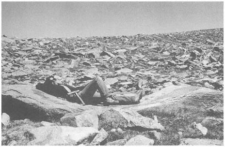
Figure 2.1
Weathering of granitic rocks may result in the formation of angular fragments along joint
planes or rounded forms with pressure release. Here a combination of mechanical and
chemical weathering processes has resulted in the formation of a very large weathering
pit (note person lying in it for scale) in Mt. Barcroft Granodiorite below White Mountain
Peak. Felsenmeer surrounds this unusual boulder.
years. In conjunction with this, Valmore LaMarche (1968) has measured weathering and erosion on slopes inhabited by Bristlecone Pine (Pinus longaeva ). Tree roots are exposed through time as material is removed around them. Using dendrochronology (tree-ring dating), LaMarche was able to quantify the amount of material removed for a given unit of time. Elliott-Fisk (1987) has investigated the weathering of glacial till boulders deposited by a series of glaciers over time; her results show that weathering is slow but progressive in the White Mountains. All of these researchers have shown that weathering is a relatively slow process in the dry climate of the White Mountains. Because precipitation (available moisture) increases with altitude (to the crest), weathering may be thought to be more rapid at higher elevations, but it must be remembered that temperature decreases with altitude as well, and frost and ice are weathering agents.
It may prove fruitful to look at the relative degree of soil development as an indication of weathering along an altitudinal gradient through the range. Soils form as the result of weathering and the decomposition of organic matter and are functions of climate, organisms, parent material, relief, and time (Jenny, 1941). Thus, one must try to hold these factors constant to assess the relative importance of climate (or altitude) to soil formation and weathering. It is possible to find the same geologic formation (for example, a particular granitic pluton) at different altitudes in the range. The relief, or slope position, can also be held constant. If we can determine
that the surface of the landscape has not been exposed to disturbance through various erosional or depositional agents, time can also be held constant. However, it has been difficult to locate a sequence of landforms of the same age that span the range's entire elevational gradient. Elliott-Fisk (1987) has studied soils formed on glacial deposits of different ages (i.e., allowing time to vary) and shown that soils do progressively develop through time. It is also difficult to hold the organisms, especially the vegetation, constant as one goes up an altitudinal gradient. Sagebrush (Artemisia spp.) communities span virtually all altitudes of the range, but, as their productivity varies, they do not allow soil development to be evaluated only as a function of climate.
Erosion
Erosion, the second geomorphic process, is the removal of weathered material from a slope. In order for material to be removed from a slope, its initial inertia must be overcome by the mass and momentum of the erosional agent. Erosional agents include running water (streams, rivers, sheetflow, soil water, and groundwater), glacier ice, ground ice, waves, tides and currents, wind, gravity, and organisms (especially humans). Geomorphic agents are linked to climate because some of them occur only in particular climatic settings, and their relative importance varies with the climate of an area. Waves, tides, and currents are obviously limited to water bodies, and gravity is common to all slopes, regardless of climatic setting. However, running water, glacier ice, ground ice, wind, and organisms (to some degree) vary with climate. All of these terrestrial geomorphic agents have operated in the White-Inyo Range during recent geologic time.
It is possible to reconstruct climatic events of the recent or distant past by studying landforms. Beaty (1963, 1968, 1970, and 1974) has worked for many years on determining the role that debris flows play in the development of alluvial fans flanking the White Mountains (Fig. 2.2). Debris flows are triggered by intense summer thunderstorms or very rapid snowmelt, where a large amount of weathered material is catastrophically eroded, transported down valley, and deposited at the valley floor on the alluvial fan. Debris flows and other deposits that result from flooding can be devastating on the landscape below, especially if it is inhabited, so these events are regarded as natural hazards. By mapping and dating debris flows, one may be able to calculate the periodicity of the events (with changes in frequency and magnitude of the flows an indication of climatic change) and use this information to estimate the probability of their recurrence.
Another erosional agent that has left its mark on the eastern slope of the White Mountains is the glacier (Fig. 2.3). A glacier is a moving body of ice; ice actually flows through a glacier much as water slowly flows down a stream channel. The moving ice can erode and transport materials, later depositing them down gradient (e.g., down valley). A series of valley glaciers formed south to north from Wyman Creek to Trail Creek along the eastern slope of the White Mountains, on high plateaus along the crest, and in the upper reaches of a few of the western drainages (Elliott-
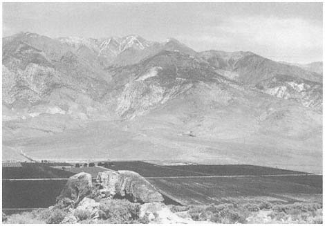
Figure 2.2
Several alluvial fans are visible here fronting the western mountain escarpment below
White Mountain Peak. The largest fan to the left center is that of Lone Tree Canyon.
A light-colored, recent debris flow extends down the center of the fan. Dark, irrigated
fields of alfalfa are seen just beyond the foreground of the Bishop Tuff Volcanic Tableland.
Fisk, 1987). Studies of glacial landforms (Elliott-Fisk, 1987; Elliott-Fisk and Dorn, 1987; Swanson et al., 1988) show at least six stages of Quaternary glaciation that correlate with the glaciations of the Sierra Nevada and also provide more detailed information on the glacial history of the region. One can reconstruct climate during these glacial events using several techniques, perhaps most directly by mapping the glacial deposits, reconstructing the glacier that deposited them, and then determining the climatic conditions necessary to form such a glacier.
Deposition
After the materials are transported by the erosional agent, they are eventually deposited at a new location. Deposition is the third geomorphic process. These depositional materials commonly form distinct landforms that are attributed to a particular geomorphic agent. These landforms can then be identified as fluvial (running water), glacial (glacier), colluvial (gravity), periglacial (ground ice), aeolian (wind), marine (waves, tides, and currents), or biological (organisms) in origin. They too can then yield climatic information, as these depositional agents vary with climate.
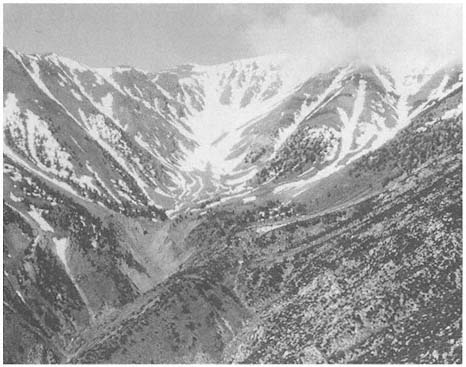
Figure 2.3
The upper part of the South Fork of Perry Aiken Creek's drainage basin was once occupied
by coalescing cirque and valley glaciers. Linear or lobate deposits seen along the valley
bottom in the center of the photo are glacial moraines (depositional landforms). Initial work
suggests that these moraines are from three glaciations that occurred during the past 200,000
years. A small rock glacier is visible above the uppermost moraine, along with several
avalanche/talus chutes and fans.
Depositional landforms commonly can be identified by their distinctive shapes, but landforms deposited many years ago may have been worn down by weathering processes and lost their once-distinct appearance. It is still possible to identify these landforms as to their depositional agent based on knowledge of how various geomorphic agents shape and sort materials. Table 2.2 lists the characteristic shapes and degrees of sorting of sediments by various agents. This table serves as a guide to identifying depositional landforms in the White-Inyo Range. It can be seen from this chart that glacial clasts (particles) are commonly subangular and poorly sorted, in contrast to fluvial clasts, which are rounded and well sorted. (These differences are due to the densities and velocities of the fluids [agents], among other factors.) Thus, if we find a deposit with no characteristic morphology on a ridgetop, valley floor, or intermediate slope, we can commonly identify its agent of deposition. Early Quaternary high-altitude ridgerop (interfluve) deposits on Cottonwood Plateau (Fig. 2.4) and Chiatovich Flats (Fig. 2.5) have been identified as glacial in origin by sediment analyses, as surface expression of glacial landforms is lacking.
| |||||||||||||||||||||||||||
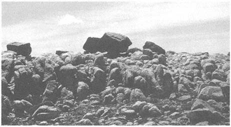
Figure 2.4
Glacial erratics are present on high plateaus or interfluves between valley bottoms in the
White Mountains. Here, erratics of the Barcroft Granodiorite rest on a highly weathered
surface of Reed Dolomite on the Cottonwood Plateau. It is believed that these and other
glacial features indicate the former presence of an ice cap in the range in the mid- to
early Quaternary time (Elliott-Fisk, 1987).
Geomorphologists have long been interested in the presence of apparent high-altitude planation surfaces at crestal and mid-elevation positions in many mountain ranges (see Fig. 2.5). These surfaces are commonly present on fault-block mountains and have been hypothesized to have been eroded in valley floor positions, then uplifted with the range. They are typically mantled with depositional material. It is possible to identify multiple planation surfaces at several distinct elevations in a particular mountain range. If these surfaces were formed at valley bottom locations, determination of their time of formation could shed light on rates of tectonic activity for a range (e.g., when was the range uplifted?) (Curry, 1984). However, many workers believe that these high-altitude surfaces were simply eroded in place by various agents, especially frost action (ground ice); as such, they have been referred to as cryoplanation surfaces. A third group of scientists believe that these surfaces were very likely the result of both past lower-elevation and present higher-elevation processes.
High-altitude erosion surfaces are distinct in the White Mountains. The best example is Pellisier Flats, which extends from an elevation of 12,400 ft (3,775 m), near Mt. Hogue at the south, to 13,400 ft (4,080 m) at The Jumpoff, just south
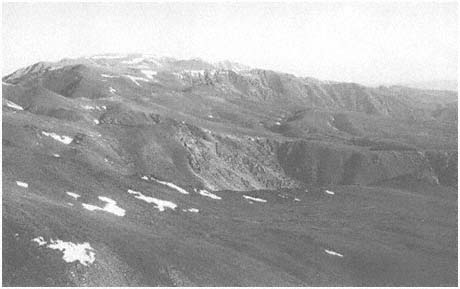
Figure 2.5
Several high-altitude planation surfaces are visible looking north along the east side of the
White Mountains. In the foreground is Perry Aiken Flat (10,460–11,880 ft, 3,190–3,620
m elevation), mantled with various periglacial landforms (such as gelifluction lobes). The
valley just to the north is glaciated Leidy Creek Canyon, with the headwaters of Cabin
Creek (surrounded by stands of dark Lodgepole Pine) imposed upon Chiatovich Flats
just beyond. Indian Creek cirque is to the north of Chiatovich Flats, with Pellisier Flats
seen as the range crest along the top of the photo. These high-altitude surfaces are
exposed to primarily periglacial geomorphic processes today, although glacial ice and
running water played an important role in shaping these surfaces in the past.
of Boundary and Montgomery peaks to the north. What appears to be an extremely flat surface from distant positions to the west or east of the range is actually a gently rolling surface with small, residual bedrock outcrops (inselbergs, tors, and monadnocks) (Fig. 2.6). The surface is mantled with frost-shattered debris and is presently a periglacial landscape. Both active and relict patterned ground occur here (Mitchell, LaMarche, and Lloyd, 1966; Elliott-Fisk, 1987; Mahacek-King et al., 1987) and dominate the surficial geology of other high plateaus in the range.
Ongoing research focuses on how extensively these plateaus were covered with glacial ice, which requires either the formation of an ice cap, under present topographic constraints, or the presence of valley glaciers prior to tectonic uplift and an episode of major stream incision (valley formation). Many of the high plateau surfaces are mantled by glacial deposits that have been somewhat reworked by frost action and fluvial processes (Elliott-Fisk, 1987). Chiatovich Flats (10,200–11,600 ft, or 3,130–3,560 m, elevation) and the Cottonwood Plateau (11,200–12,000 ft, or 3,435–3,680 m, elevation) are the best examples. Other surfaces are mantled by rock glaciers (such as the North Fork Perry Aiken Creek, Fig. 2.7) and felsenmeer (i.e., frost-shattered boulder fields; see Figs. 2.1 and 2.6).
Geomorphologists have long debated whether felsenmeer indicates the absence of glaciation. This is a difficult question because our knowledge of high-altitude weather-
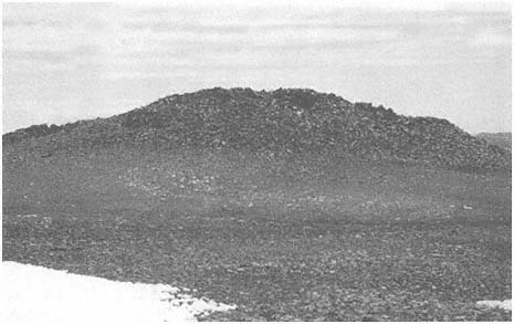
Figure 2.6
Erosional remnants (tors, inselbergs, and monadnocks) are present along the range crest
and on interfluves surrounded by weathering debris. Here, at 12,680 ft (3,865 m) elevation
on the plateau above Barcroft, a large inselberg is seen. The bedrock here is Mt. Barcroft
Granodiorite. Areas such as this were favored by early native Americans as summer home
sites and parts of game drives.
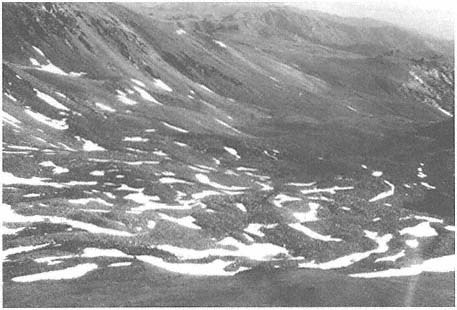
Figure 2.7
Rock glaciers occur at high altitudes in the range east of the crest in formerly glaciated
canyons. The aspect of many of these rock glaciers is north to northeast, where snow
can accumulate and be retained into the summer. The largest rock glacier in the range is
in the north branch of the North Fork Perry Aiken Creek, pictured here. Rock glaciers
such as this show movement, although inactive (relict) ones persist for some time at these
high altitudes.
ing rates is poor. The thin ice cover of a cold-based glacier (frozen to the surface) may allow the preservation of felsenmeer. The plateau between Mt. Barcroft and White Mountain Peak apparently had such an ice cover in the past, as large, frost-shattered blocks on the plateau above the cirques of the North and South Forks of McAfee Creek show surface polish and abrasion, indicating that this area was in the zone of accumulation of a former glacier (Elliott-Fisk, 1987). The same or an adjacent glacier may have deposited the granodiorite erratics on the dolomite surface of the Cottonwood Plateau to the south (see Fig. 2.4). If the time of formation of these glaciers can be deduced, the rate of high-altitude weathering since its disintegration can be calculated.
The tectonic activity of the earth can be characterized as an internal geomorphic process. Displaced, faulted, and warped landforms attest to local tectonic activity. Good examples of these exist along the western and eastern escarpments of the White-Inyo Range in the form of displaced alluvial fan (Fig. 2.8) and lake bed materials.
Alluvial fans are triangular or cone-shaped masses of debris at the base of a mountain front (see Fig. 2.2). Deposition of alluvial and colluvial material results when the lower gradient and wider channel of the valley floor are encountered as the material is transported down the mountain flanks. The velocity of the fluid drops, causing
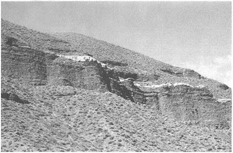
Figure 2.8
Raised alluvial fan materials (fanglomerates) are seen here along the south flank of Black
Canyon on the western slope of the White Mountains. The white layer between these
deposits is Bishop Tuff (including lapilli-size particles), which was deposited about 0.79
Ma. This deposit signifies tectonic uplift of this region.
the deposition of these materials. Streams spread out as distributaries at this point, instead of coming together in the form of tributaries to a main stream channel, as they do in the drainage basin above.
As one ascends the stream canyons at the apex (head) of these alluvial fans, older fan materials (fanglomerates) may be seen perched on the walls many meters above the present fan surface (as along Indian Creek, Milner Creek, and Black Canyon). It is also possible to find an older fan apex at a higher elevation back in the mountain front (as at Jeffrey Mine Canyon on the west slope of the White Mountains). If these materials can be dated, the amount of tectonic uplift can be calculated. Unfortunately, these deposits are difficult to date, as they are usually beyond the age range of radiocarbon or lack organic materials necessary for radiocarbon dating. However, along Black Canyon in the southwestern White Mountains (see Fig. 2.8), a volcanic deposit is interbedded with fanglomerate. This material is tephra (air-filled lapilli and ash) from the catastrophic eruption of the Long Valley caldera and is referred to as the Bishop Tuff (volcanic ash) (Bateman, 1965). It has been dated by uranium fission and other techniques, with the best estimate of its age currently at 0.79 Ma (millions of years before present). This deposit is present in Black Canyon 490 ft (150 m) above the valley floor, attesting to 7.6 in (19 cm) of uplift per 1,000 years.
Near the Westgard Pass road at the Waucoba Embayment of the western front of the White-Inyo Range, a series of lake beds (the Waucoba Lake beds) is exposed.
Walcott (1897) speculated that these lake deposits have been uplifted 3,300 ft (1,000 m) above the valley floor. Although intensive studies of these deposits have not yet been conducted, their age is estimated at 3 million years, suggesting an uplift rate of 13 in (33 cm) per 1,000 years.
The relatively slow tectonic uplift of the range may not seem important in reference to our short lifetimes, but some tectonic activity, generating earthquakes and displacement along fault lines, can be abrupt. Escarpments along fault lines cutting through alluvial fans suggest rapid vertical displacements of several meters. Further research needs to focus on dating this tectonic activity, which can be accomplished through studies of soil formation on the fans. The presence of ash from the Mono and Inyo craters interbedded with uplifted fan sequences and other deposits (Fig. 2.9) suggests tectonic disturbance in the last 5,000 years (Mahacek-King et al., 1987; Mahacek-King et al., 1988). It is now well known that the entire region is tectonically, and hence geomorphically, very active, as has been shown by intensive studies in the Long Valley caldera region and along the White Mountains fault zone, and by historical records of earthquake occurrence. It is believed by some workers (Curry, 1984) that this tectonic activity is accompanied by volcanism and basin formation and is migrating north from the Owens Valley (which witnessed a catastrophic eruption about 790,000 ka (thousands of years before the present) to the Mono Basin (which is still volcanically active) and the Bridgeport basin. This may be related to major plate rifting along the axis of the Gulf of California and to crustal extension.
A wide variety of materials is available for landform generation in the White-Inyo Range. All three basic rock classes (igneous, metamorphic, and sedimentary) are present and range from Precambrian to Quaternary in age (see Chapter 3). The mineralogy and petrology of these rocks vary, with some more susceptible to jointing, chemical weathering, and other processes. Thus, some types of landforms tend to be associated with distinct rock formations. For example, the Campito Formation (especially the Andrews Mountain Member), a sandstone or quartzite, is very susceptible to frost action, resulting in the formation of angular felsenmeer seen as stone stripes on slopes along White Mountain Road. Bateman (1965) contrasts this with the Montenegro Member shale, which forms slabs and breaks down rapidly to clay-rich soils. Differences in patterned ground derived from metamorphic and granitic materials are apparent at high elevations.
The White-Inyo Range is largely lacking in organic-rich deposits and landforms, in the form of either peat or fossilized organic remains. This is most likely due to the present aridity of the range and the lack of topographic depressions along the steep mountain flanks. Organic-rich deposits may compose distinct landforms, but they possess other advantages in that they are a superb source of material for the study of fossil plant and animal communities and for dating of geomorphic events (see Fig. 2.9). Recently, turf and earth hummocks have been found in the Alpine Zone of Pellisier Flats and register geomorphic change with the deposition of volcanic tephra and changing hydrology of the site (Mahacek-King et al., 1987). The arid climates of the range have allowed woodrat middens to be preserved in a diversity
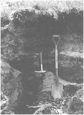
Figure 2.9
Organic-rich deposits are occasionally found along
stream terraces, primarily on the east side of the range.
The study of sediments, soil, and fossils in this
stratigraphic section (stream cut) yields valuable
information on the late Holocene (past 3,000 years)
behavior of Crooked Creek. The two light layers to the
left of the shovel are volcanic ash from the Mono and
Inyo craters and serve as valuable time-stratigraphic
markers.
of environments. Analysis of plant macrofossils from these middens is providing valuable information on the late Quaternary geologic and climatic history of the range (Jennings, 1988; Jennings et al., 1989).
Reference has been made throughout this section to the role of time in the control of landform development. If we think of the White-Inyo Range as a dynamic mountain system that is continuing to evolve, we can ask not only what landforms are developing now, but which ones were formed in the past, when they were formed, and what this tells us about the evolution of the range.
The geologic evolution of the range is discussed in Chapter 3 of this book. However, in a general sense, it can be stated that all landforms visible today are the
products of late Cenozoic processes. We can imagine many of the high peaks (such as White Mountain Peak) forming over millions of years through weathering and erosion. It is very likely that the peak was always exposed to the subaerial environment, perhaps a nunatak above a hypothetical White Mountain ice cap. Other landforms are more recent, forming with the glaciation of the range or by recent fluvial activity.
References
Bateman, P. C. 1965. Geology and tungsten mineralization of the Bishop District California . U.S. Geological Survey Professional Paper 470.
Beaty, C. B. 1963. Origin of alluvial fans, White Mountains, California and Nevada. Annals, Association of American Georgarphers 53:516–535.
Beaty, C. B. 1968. Sequential study of desert flooding in the White mountains of California and Nevada . Technical Report 68-31-ES. U.S. Army natick Laboratories, Natick, Mass., January.
Beaty, C. B. 1970. Age and estimated rate of accumulation of an alluvial fan, White Mountains, California, U.S.A. American Journal of Science 268:50–77.
Beaty, C. B. 1974. Debris flows, alluvial fans, and a revitalized catastrophism. Zeitshrift für Geomorphologie , N.F. Suppl. Bd. 21:39–51.
Curry, R. R. 1984. Mountain summit glacial tills and their tectonic implications, eastern Sierra Nevada, California. Abstracts, Annual Meeting of the Geological Society of America , Reno, Nevada, p. 481.
Elliott-Fisk, D. L. 1987. Glacial geomorphology of the White Mountains, California and Nevada: Establishment of a glacial chronology. Physical Geography 8:299–323.
Elliott-Fisk, D. L., and R. I. Dorn. 1987. Pleistocene glaciation of the White Mountains, CA-NV, and correlation with the Sierra Nevada. Geological Society of America, 1987 Annual Meeting, Abstracts with Programs , p. 655.
Gregory, K. J. 1978. A physical geography equation. National Geographer 12:137–141.
Jennings, S. 1988. Late Quaternary vegetation change in the White Mountain region. In C. A. Hall, Jr. and V. Doyle-Jones (eds.). Plant biology of eastern California . Natural History of the White-Invo Range, symposium vol. 2, pp. 139–147. University of California, Los Angeles.
Jennings, S. A., D. L. Elliott-Fisk, T. W. Swanson, and R. I. Dorn. 1989. A late-Pleistocene chronology of the White Mountains, CA-NV. Association of American Geographers Program Abstracts, Baltimore . Washington, D. C.
Jenny, H. 1941. Factors of soil formation . McGraw-Hill, New York.
LaMarche, V. C., Jr. 1968. Rates of slope degradation as determined from botanical evidence, White Mountains, California . U.S. Geological Survey Professional Paper 325-I, pp. 341–377.
Mahacek-King, V. L., J. A. Onken, D. L. Elliott-Fisk, and R. L. Bettinger. 1987. Quaternary silicic tephras in the White Mountains, CA-NV: Depositional environment and geomorphic history. Geological Society of America, Annual Meeting, Abstracts with Programs, p. 756.
Mahacek-King, V. L., D. L. Elliott-Fisk, T. E. Gill, and T. A. Cahill. 1988. Elemental analysis by PIXE applied to tephrochronology of the White Mountains, California-Nevada. Geological Society of America, Abstracts with Programs , vol. 20, no. 7, p. A54.
Marchand, D. E. 1968. Chemical weathering, soil formation, geobotanical correlations in a portion of the White Mountains, Mono and Inyo Countries, California. Ph. D. thesis, University of California, Berkeley.
Marchand, D. E. 1970. Soil contamination in the White Mountains, eastern California. Geological Society of America, Bulletin 81:2497–2505.
Marchand, D. E. 1971. Rates and modes of denudation, White Mountains, eastern California. American Journal of Science 270:109–135.
Marchard, D. E. 1974. Chemical weathering, soil development, and geochemical fractionation in a part of the White Mountains, Mono and Inyo Counties, California . U.S. Geological survey Professional Paper 352-J.
Mitchell, R. S., V. C. LaMarche, and R. M. Lloyd. 1966. Alpine vegetation and active frost features of Pellisier Flats, White Mountains, California. American Midland Naturalist 75:516–525.
Swanson, T. W., D. L. Elliott-Fisk, R. I. Dorn, and F. M. Phillips. 1988. Quaternary glaciation of the Chiatovich Creek Basin, White Mountains, CA-NV: A multiple dating approach. Geological Society of American, Abstract with Programs , vol. 20, no. 7, p. A209.
Walcott, C. D. 1897. The post-Pleistocene elevation of the Inyo Range, and the lake beds of Waucobi Embayment, Inyo County, California. Journal of Geology 5:340–348.