II
The Achievement of the English Voyages, 1650-1800
Glyndwr Williams
The first hundred years of the period under study fall within the era which Oskar Spate has categorized as "the Dark Age of Pacific historiography,"[1] the long interval between the first hesitant European incursions of the sixteenth century into the Mar del Zur and the systematic explorations of the late eighteenth century. From Magellan onward Europeans of several nations—Spaniards, French, Dutch, English—had ventured into, and sometimes across, the Pacific; but their explorations were for the most part inconclusive and little known. The immensity of the ocean, 10,000 miles in each direction, primitive methods of navigation, the ravages of scurvy, and the straitjacket of wind and current posed apparently insuperable obstacles to methodical exploration. After Tasman's voyages in the 1040s the slow-moving course of Pacific discovery practically came to a halt. To the north Japan was roughly charted, but the ocean to the north and east remained unexplored. The Pacific coast of America was known only as far as California, a peninsula on some
maps, an island on others. In the South Pacific a fair knowledge had been obtained of the island groups lying on the diagonal course between the tip of South America and New Guinea, but their exact position and extent were largely a matter for conjecture. The western fringes of Australia, the southern coast of Tasmania, and a stretch of the New Zealand shoreline were known from the Dutch explorations; but the relationship between these lands was far from clear. In particular, it was not known whether any of them formed part of the great southern continent—terra australis incognita . The case for a southern continent was as old as geographical science, for Ptolemy in the second century had argued that there was a huge counterbalancing landmass in the Southern Hemisphere; and believers in the concept were not unduly depressed by the failure of the explorers of the sixteenth and seventeenth centuries to bring back conclusive evidence. Since vessels tended to follow a track which slanted away from high latitudes as it left Cape Horn, mapmakers merely had to shift their continent a degree or two farther south. Geographers found compensation for this limited retreat by hinting that the islands (or cloud banks) sighted by the explorers to port were in fact the outlying capes and promontories of a continent lying just over the horizon.
English interest in the Pacific was chauvinistic and materialistic. In the pages of Hakluyt and Purchas it was the circumnavigations of Drake and Cavendish, spectacular in intention but meager in geographical information, which took the limelight. As the title page of the Principall Navigations announced, they were "the two renowned and prosperous voyages . . . round about the circumference of the whole earth." When English attention revived in the second half of the seventeenth century, the motives were the same as those which had prompted the Elizabethans: trade and plunder. The Pacific caught the English imagination not as a vast, trackless ocean but as the western rim of Spain's American empire. The "South Sea" which now began to exercise its fascination over distant enterprises
was confined, in English eyes, to the waters which lapped the shores of Chile, Peru, and Mexico. The voyages, from Narborough's of 1669-1671 to Anson's of 1740-1744, produced some useful information.[2] Narborough's Peruvian venture—the first English expedition to enter the Pacific since Richard Hawkins in 1594—was a failure, but it resulted in a map of the Strait of Magellan which long remained a standard authority. Better received in England than this disappointing enterprise were the exploits of the buccaneers who pillaged and burned along the Pacific shores of Spanish America. Among them were men with literary skills, notably William Dampier, a gifted observer whose books became classics of travel and adventure (Figure 2.1). Although Spanish America and the East Indies saw most of him, he also ventured into areas on the very periphery of Europe's knowledge. He briefly touched on the western shores of Australia in 1688 and 1699, and to the east he discovered a large island (later found to be adjoining islands) which he named New Britain. His descriptions of the Australian Aborigines were the first recorded by any Englishman, and more than seventy years later when Cook and Banks reached the east coast of Australia in the Endeavour it was Dampier's unflattering account which they had with them and which influenced their first encounters.[3]
Otherwise, the voyages of Dampier and his privateer-successors such as Rogers and Shelvocke produced little in the way of geographical discovery and paled in significance before the altogether more numerous and expert French ventures to the Pacific coasts of Spanish America and across to China. In some ways, more of a precursor of the expeditions of the second half of the eighteenth century were the voyages of Edmond Halley in the Paramore (1698-1701), concerned with new navigational methods rather than with new lands and above all intended "to improve the knowledge of the Longitude and variations of the Compasse."[4] They stand as a landmark in the history of English oceanic enterprise, not least in the burgeoning relationship they revealed between the Admi-
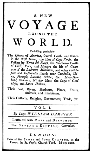
Figure 2.1.
Title page of Dampier's New Voyage . . . , 7th ed. 1729),
p. 3. (Reproduced courtesy of the Bancroft Library.)
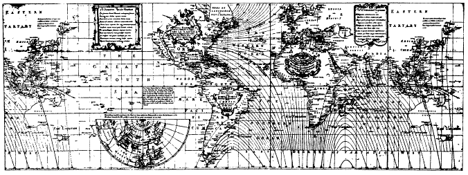
Figure 2.2.
Halley's "New and Correct Sea-Chart of the Whole World" (1702). (Reproduced courtesy of the Bancroft Library.)
ralty and the Royal Society, a relationship which reached proper consummation in the Pacific voyages of George III's reign. Although there was originally some intention of reaching "the East Indies or South Seas," Halley's voyages took him no further than the South Atlantic, and the largest blank space on his magnificent world map of 1702 showing magnetic variation was the Pacific (Figure 2.2). As he explained: "I durst not presume to describe the like Curves in the South Sea wanting accounts thereof."[5] Accounts or no accounts, the region was no longer quite terra incognita . The seas beyond Cape Horn were not simply the haunts of buccaneers and adventurers; they also provided the setting for some of the most popular fiction and satire of the period—from Crusoe to Gulliver. After the disillusionment of the South Sea Bubble, activity both practical and literary slumped. Indeed Defoe complained that it was "as if we had done our utmost, were fully satisfied with what we have, that the enterprising Genius was buried with the old Discoverers, and there was neither Room in the World nor Inclination in our People to look any further."[6]
Revival came with the heightening of international tension in the 1740s. A naval expedition commanded by Christopher Middleton sailed for Hudson Bay in 1741 in an unsuccessful attempt to find a Northwest Passage—a venture explained in part by a determination to thwart French expansion in the western interior of North America, in part by a hope of striking at Spain's Pacific possessions from the rear. But above all there was Anson's voyage, that melodramatic episode of wartime disaster and heroism which brought back memories of Drake and half-forgotten feats of arms against the Spain of Philip II. The official narrative of the expedition became a bestseller among travel accounts. It was more than a tale of treasure seeking on the high seas, though this no doubt was the prime reason for its popularity. At one level it was designed to encourage "the more important purposes of navigation, commerce, and national interest,"[7] while at another it made an appeal to the imagination, with reminders
of Crusoe's island and Rousseau's Nouvelle-Héloïse .[8] It strengthened the hold of tropical island fantasies on the European consciousness, a continuing fascination which was to last into the nineteenth century with Melville, Stevenson, and Gauguin.[9]
As considerations of geographical science, government strategy, and mercantile acquisitiveness combined in pointing to the exploration of the Pacific as one of the most important global objectives left to Europeans, so in Paris in 1756 Charles de Brosses published the first collection of voyages devoted exclusively to the Pacific, Histoire des navigations aux terres australes . Plagiarized by John Callender in his English edition, confidently retitled Terra Australis Cognita , this work contained accounts of the main Pacific expeditions from Magellan to Anson. Reading these pages confirms that the earlier voyages had produced as much confusion as enlightenment. Islands had been sighted and resighted, identified and then lost again; distant volcanic peaks had been mistaken for continental ranges; straits had become bays, and bays straits. The map of the Pacific was dotted with island groups whose names and positions changed with the whims of cartographical fashion, and it was scarred with squiggles of coastline which hinted at intriguing but still undiscovered lands of continental dimensions. As the astronomer William Wales tersely remarked during the course of Cook's second voyage, "I firmly believe Islands have been greatly multiplied, and Much Confusion has arisen in the Geography of these seas from a desire of being thought the first discoverers of any land that has been seen."[10] If the geography of the Pacific was uncertain and fanciful, so too was knowledge of its inhabitants. The observations of the explorers were usually hasty and superficial, often the result of only a few days', sometimes only a few hours', stay. Encounters varied from violent to friendly, but misunderstanding was more common than comprehension, and all too often contact ended with the blast of cannon or musket on one side and a shower of stones and arrows on the other.
The Seven Years' War put an end to schemes for Pacific exploration, but in both Britain and France official discovery expeditions were mounted soon after the conclusion of peace in 1763. The first Pacific expedition in the new era of oceanic exploration was that of Commodore John Byron in 1764—a false start in many ways, for despite his comprehensive instructions and his assurance to the Admiralty that he intended to cross the Pacific "by a new track" Byron followed the customary route west-northwest from the Strait of Magellan and consequently made no discoveries of note. His rediscovery and annexation of the Falklands had a political rather than a geographical significance, and that he completed his circumnavigation in well under two years showed his inability to distinguish between an explorer and a record breaker.[11]
In 1766 two further vessels were fitted out under Captain Wallis and Lieutenant Carteret, who were ordered to search for the great unknown continent in more southerly latitudes. After a hard passage through the Strait of Magellan the ships were separated and made individual voyages. Carteret proved an enterprising commander and crossed the Pacific farther south than any other explorer had done, thus making considerable inroads into the conjectural southern continent. He also rediscovered, though he did not identify, the Solomon Islands almost two centuries after they had first been sighted by the Spaniards. Wallis, by contrast, showed little initiative in his track across the ocean, but his voyage was marked by a chance discovery whose emotional impact was out of all proportion to its geographical significance, for in June 1767 the crew sighted, and landed at, Tahiti. It was the first of those meetings between sailors and Polynesian women which were to stamp an erotic imprint upon England's image of the South Seas. To the breaking surf, the palm-fringed beaches, and the gentle climate were added sensuous overtones—of welcoming, garlanded women. When Bougainville's ships reached Tahiti the following year, reactions were even more effusive and extravagant. The island was
named New Cythera by some of the French after Aphrodite's island, and Tahiti long remained a symbol of the romance of the Pacific islands in defiance of those cautionary voices which pointed to the darker side of life there.
Despite these additions by British and French explorers to knowledge of the island groups of the South Pacific, little progress had been made toward solving the crucial issue of terra australis , though hopes had been raised with the claimed sighting by Wallis's crew of "the tops of several mountains the Extreems bearing from South to S.W. upwards of twenty Leagues," just south of Tahiti.[12] The lands east of New Holland remained marked on the maps as they appeared after the Dutch discoveries of the previous century—in effect, swirling question marks (Figure 2.3). Yet within a few years there was no longer any doubt. The South Pacific took shape on the maps in much the same form it has today, and the man responsible for this leap in knowledge, and for much else, was James Cook. His three voyages, following each other in quick succession, revealed the Pacific to Europe in a way no previous explorations had done. As the books, maps, and views came off the presses—not only in England but in France, Holland, Germany, and Italy as well—Cook became a figure of European renown. Other explorers were in the Pacific during the years that Cook's ships were out, but attention was focused on the methodical, comprehensive explorations of the remarkable Englishman.
Lieutenant Cook, as he was on the first voyage, had taken part in the surveying of the St. Lawrence River during Wolfe's campaign, and between 1763 and 1767 he had made detailed charts of the fog-shrouded coastline of Newfoundland. He had studied, in practical fashion, mathematics and astronomy, and in contrast to some of his predecessors in the Pacific he possessed the technical skills needed to make an effective explorer. The next few years were to show that in addition he was gifted with those less tangible qualities of leadership, determination, and judgment which were to make him the outstanding explorer of the eighteenth century. As he once wrote, it was his ambi-
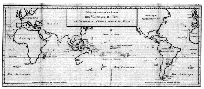
Figure 2.3.
The Pacific before Cook: Bougainville's track, 1767-1768. From
"Dévelopement de la Route des Vaisseaux du Roy . . ." in L. A.
de Bougainville, Voyage autour du Monde (1771). (Reproduced
courtesy of the Bancroft Library.)
tion not only to go "farther than any man has been before me, but as far as I think it possible for man to go."[13] Supported by an Admiralty willing to allow detailed publication of the expeditions' findings, Cook and his officers were able to give a fuller picture of the Pacific than had emerged during the previous two centuries and more of sporadic, often secretive exploration. As recently as Bougainville's voyage, the published narrative suppressed much in the way of precise observation, so that it was, as Carteret put it, "more amusing to the landsmen than usefull to the Seaman."[14]
Cook's instructions of 1768—more detailed than those of Byron or Wallis—were to report on all aspects of new lands discovered and to bring back specimens, drawings, and surveys. Joseph Banks followed the precedent set by the French (Bougainville had on board the astronomer Veron and the naturalist Commerson) to argue that artists and scientists should accompany the discovery expeditions. Though the scientific equipment seems primitive by modern standards, the ships were in eighteenth-century terms floating laboratories. The Admiralty took advantage of the length of the voyages to put on board a whole range of experimental equipment and foodstuffs—from a device for distilling fresh water from sea water to carrot marmalade. Even Dr. Johnson, no enthusiast for oceanic discovery, had called for voyagers with a scientific turn of mind, intent on "every object of curiosity, and at leisure for the most minute remarks."[15] Shortly before the expedition sailed, the president of the Royal Society, Lord Morton, appealed to Cook and Banks for "the utmost patience and forbearance with respect to the natives of the several lands where the ship may touch," and he went on to encourage them "to observe the genius, temper, disposition and number of the natives."[16] Understandably, Cook felt more at ease in describing the geography of the Pacific than its peoples. However difficult to follow an intricate coastline might be, it could be traced, surveyed, pinned down on a chart—and there it would remain, unvarying
in outline over the years. Investigation of the human population of these areas had no such firm basis—not only was there among the different peoples of the Pacific no fundamental similarity of culture or language, there was no accepted method of categorization and classification. Though more serious in intent than their predecessors, Cook and his companions had no scientific base from which to operate. Simple stereotypes of noble primitives, hazy ideas of Rousseauistic philosophy, a nodding acquaintance with some of the deist literature of the day, had little relevance to the problems of understanding which confronted the explorers.[17]
These problems were the more difficult to solve because of the strained nature of the contact. The Pacific navigators of the period were for the most part moderate and humane commanders—by earlier standards remarkably so. Nevertheless the Europeans were intruders, emerging by the score from their great vessel anchored in some island bay, atua or "men from the sky," appearing and disappearing without warning, often violating sacrosanct customs and sacred ground. Over the encounters between voyagers and islanders hung an inescapable tension, sometimes dissipated by individual contacts and trade which offered benefits to both sides, but on other occasions erupting into violence. In the long term, the introduction of venereal disease, alcohol, and firearms brought a depressing and familiar train of consequences: sickness, demoralization, depopulation. It was these voyages which helped give birth to the new disciplines of ethnology and anthropology, but as Malinowski pointed out more than fifty years ago, "ethnology is in a sadly ludicrous, not to say tragic, position, that at the very moment when it begins to put its workshop in order . . . the material of its study melts away with hopeless rapidity."[18]
This was all in the future when Cook, still unknown outside a narrow circle of naval men, left England in 1768 in the Endeavour for his first Pacific voyage. His vessel was not the usual neat naval sloop or fast frigate but a bluff-bowed
Whitby collier chosen for her strength, shallow draft, and storage capacity. Although Cook wrote that she was "the first ship of the kind so imploy'd," there had been earlier attempts by the Navy Board to match the vessel with the mission. Halley's Paramore was a pink with capacious storage and little draft, while Middleton's Furnace bound for the ice of Hudson Bay had started life as a bomb vessel with stout timbers designed to withstand the battering recoil of a heavy mortar. Although Cook's ship was to change, the type was not; the Resolution of the second and third voyages was of the same build and even came from the same shipyard as the Endeavour , of which Cook wrote: "It was to these Properties in her those on board owe their Preservation. Hence I was enabled to prosecute Discoveries in those Seas so much longer than any other Man ever did or could do."[19]
He sailed first to Tahiti to carry out those astronomical observations which were the ostensible reason for the expedition before he turned south where, his instructions told him, "there is reason to imagine that a Continent or Land of great extent, may be found."[20] But he reached latitude 40° south without sighting land. and he noted that the long rolling swell coming from the south argued against the existence of any landmass in that direction. He then turned west to New Zealand, whose coast he mapped in a little over six months by means of a superb running survey from the sea which showed beyond doubt that the two islands were not part of any continent (Figure 2.4). From there Cook went well beyond his instructions as he pointed the Endeavour toward a region of mystery: the unexplored eastern parts of New Holland. Cook reached Australian shores just north of Van Diemen's Land and slowly coasted northward, mapping as he went. After a hair-raising escape from the dangers of the Great Barrier Reef he went on to sail through Torres Strait, thus settling the dispute as to whether New Holland and New Guinea were joined.
Cook had carried out his instructions and more—an explorer who simply followed orders would never accom-
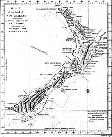
Figure 2.4.
James Cook: chart of New Zealand (1770), from John Hawkesworth,
ed., An Account of a Voyage round the world . . . (London, 1773).
plish great things, he later told a French inquirer.[21] With only one ship he had put more than 5,000 miles of previously unknown coastline on the map. The twin islands of New Zealand, the east coast of Australia, and Torres Strait had at last emerged from the mists of uncertainty to be precisely placed on the map. On the negative significance of the voyage as far as it related to the great southern continent, Cook was emphatic and skeptical: "I do not believe
any such thing exists unless in a high latitude . . . hanging Clowds and a thick horizon are certainly no known Signs of a Continent."[22]
This feat of detailed exploration had been accomplished without the loss of a single man from scurvy— most of the forty-one deaths on the voyage came from malaria and dysentery picked up at Batavia on the homeward journey. The work of specialists has corrected the popular view that Cook was responsible for discovering and enforcing the cure for scurvy on long sea voyages. His approach was rather that of the blunderbuss, as Sir James Watt has put it.[23] Even so, there remains an outline of truth in the conclusion of a contributor to The Medical and Physical Journal in 1799 that Cook "proved to the world the possibility of carrying a ship's crew through a variety of climates, for the space of near four years, without losing one man by disease; a circumstance which added more to his fame, and is supposed to have given a more useful lesson to maritime nations, than all the discoveries he ever made."[24]
The public saw the first voyage through the eyes of John Hawkesworth, who fused the separate journals of Cook and Banks into a single narrative to make the Endeavour expedition the resounding climax to his Voyages of 1773, which took in also the accounts of Byron, Wallis, and Carteret. An editor of literary rather than nautical expertise, Hawkesworth inserted reflective and philosophical passages, switched locations and opinions, idealized the commanders and their crews, and generally made frequent and sometimes substantive changes to the journals. Publication led to dispute and controversy in which Hawkesworth was attacked for the work's frank descriptions of Polynesian sexual customs, for skepticism about the "particular interposition of Providence," and for technical inaccuracies.[25] Doubts were expressed about the authenticity of the text—summed up by Boswell when he remarked to Cook that Hawkesworth "has used your narrative as a London tavern keeper does wine. He has brewed it."[26] The ensuing stir no doubt persuaded Cook and his suc-
cessors to keep publication of their later journals out of the clutches of literary gentlemen, but there can be no doubting the impact and popularity of Hawkesworth's Voyages . The book soon went into other editions and other languages, and an analysis of borrowings from a major lending library of this period shows that of all works held by the library, Hawkesworth was the most in demand.[27] As one newspaper commented, "It may be called a real authentic Account of a new World, such as no European could have figured in his own Imagination."[28]
Cook was to read and be irritated by Hawkesworth's Voyages , but not until two years after its publication. For by 1773 he was in the Pacific again. On his first voyage Cook had lopped a considerable slice off the supposed continent of the south, but there remained vast unexplored stretches in the high latitudes of the Atlantic, Pacific, and Indian oceans where land might yet be found. Pressure in Britain for another voyage mounted as reports came in that the French were again sending expeditions to the Pacific: four in fact visited the southern seas, hunting for islands and continents, between 1770 and 1773. So in 1772 Cook left England to search once more for the great southern continent, carrying on board chronometers, one of which was Kendall's copy of John Harrison's masterpiece, his fourth marine timekeeper. The instrument proved itself by keeping accurate time throughout the buffeting of the long voyage (see Figure 5.4), and one of the most persistent problems of oceanic navigation had been overcome. Much of Cook's achievement would have been impossible without the developments in navigational science and instrument making of his age—we have come a long way from the mariner's traditional three L's of Lead, Latitude, and Lookout.[29] Equipped with chronometers and improved sextants, navigators would be able to find both longitude and latitude with an accuracy sufficient for all practical purposes.
Cook's second Pacific expedition was arguably the greatest, most perfect, of seaborne voyages of discovery. In his three years away he disposed of the conjectural southern
continent, reached closer to the South Pole than any man before him, and touched on a multitude of lands—New Zealand and Tahiti again and for the first time Easter Island, the Marquesas, New Caledonia, the New Hebrides, and South Georgia. In doing so he confirmed, located, and connected many of the uncertain discoveries of earlier explorers which had brought so much confusion to the map of the Pacific. In high latitudes he crossed and recrossed the Antarctic Circle in a series of long, methodical sweeps. At his farthest he reached latitude 71° south before being stopped by the ice barrier which encircles the immense continent of the south. This was not the fertile land of the theorists' dreams but the frozen Antarctic—in Cook's words, "a Country doomed by Nature never once to feel the warmth of the Suns rays, but to lie for ever buried under everlasting snow and ice."[30] With him this time sailed that learned if awkward man, J. R. Forster, and his son George, and the painter William Hodges, whose luminous, sun-drenched landscapes evoked the South Seas as no artist had done before. The published records of the voyage were fuller and weightier than before. Cook's own journal was issued in 1777 as his Voyage Towards the South Pole , a mighty affair of over seven hundred pages; a lively account by George Forster, A Voyage Round the World , was published in two volumes a few weeks before the appearance of Cook's book; then in 1778 appeared J. R. Forster's scholarly, sometimes portentous, Observations Made During a Voyage Round the World , four hundred pages of which were taken up with "Remarks on the Human Species in the South-Sea Isles." The accounts and maps furnished conclusive proof that the populous terra australis of tradition did not exist and that exploitation of the Pacific would be pursued on a more modest scale than that envisaged by a long line of geographers and economists.
There was, thought Cook, little more to do in the South Pacific: "I flater my self that the intention of the Voyage has in every respect been fully Answered, the Southern Hemisphere sufficiently explored and a final end
put to the searching after a Southern Continent, which has at times ingrossed the attention of some of the Maritime Powers for near two Centuries past and the Geographers of all ages."[31] There was, Beaglehole has written, "something almost cruelly final" about the great voyage.[32] Cook's third and final voyage, then, had its own logic in that it took him to the North Pacific in an effort to solve another perplexing and long-standing geographical mystery: the existence of a Northwest Passage. The eighteenth-century explorations of the North Pacific before Cook had brought considerable advances in Europe's knowledge of that remote area, but also much uncertainty and speculation. At the beginning of the century no European knew what lay between California and Kamchatka. The trend of the Pacific coast of America north of Cape Blanco in latitude 43° north was unknown; how far eastward Asia stretched from the peninsula of Kamchatka was equally doubtful. In the intervening 5,000 miles there might be ocean or land, islands or continents, a land bridge between Asia and America, or the entrances to the Northwest and Northeast Passages. Slowly and hesitantly the Russians, hampered by enormous problems of logistics, began to resolve the puzzle through the expeditions of Bering and his successors. But the failure to publish the working charts of the Russian explorers, and the eagerness of speculative geographers to fill the void with their own eccentric creations, brought mystification rather than illumination to the scene. The Spaniards, too, moved north from Lower California in the 1760s and 1770s and reached, fleetingly, Alaska; but again little was known of their rather fragmentary discoveries at the time.
In taking the unfrequented route from Tahiti to the northwest coast of America, Cook made the major, and for himself fatal, discovery of the Hawaiian Islands before turning to the main task. The summer of 1778 he spent engaged in hazardous exploration along the Alaskan coast, searching in vain for the strait leading to an ice-free Arctic Ocean indicated on the maps of the theoretical
geographers. No such passage was found before Bering Strait was reached, and after only a week's sailing through that narrow opening Cook found his way blocked by a massive wall of ice grinding down upon his ships. He had been imposed upon to the world's advantage, Beaglehole has written,[33] and the results of this single season of exploration were indeed impressive. Although unaware of the insular nature of much of the coastline he was sailing along, Cook charted the main outline of America's shores from Mount St. Elias to Bering Strait, determined the shape of the Alaskan peninsula, and touched on the coast of modern British Columbia. He closed the gap between the Russian and Spanish probes. The maps brought home by Cook's officers after his death, and published with the official account of the voyage in 1784, showed the reality of his achievement. In outline, at least, the shape and position of the northwest coast of America were known, and for the first time the region takes recognizable form on the maps (Figure 2.5).[34]
On his three voyages Cook had established the salient features of the Pacific. Much remained to be done, but in the way of defining detail rather than in solving major geographical problems. There were further voyages of exploration to the Pacific before the end of the century: Vancouver's painstaking survey of the northwest American coast which corrected and completed Cook's chart, the ambitious Spanish venture under Malaspina (few of whose journals were ever published), and D'Entrecasteaux's search expedition for the ill-fated La Pérouse. It was Cook's men who dominated the English voyages to the Pacific, whether for exploration or trade: Bligh, Dixon, Portlock, Colnett, Riou, Hergest, and above all Vancouver had graduated in the most demanding of training schools. As William Windham remarked to James Burney on hearing of Bligh's incredible open-boat voyage after the Bounty mutiny, "But what officers you are! you men of Captain Cook; you rise upon us in every trial."[35] Cook's own reputation after his death "was submitted quite consciously
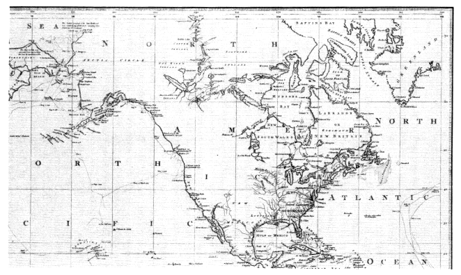
Figure 2.5.
Henry Roberts: detail from his "Chart exhibiting the Discoveries Made by Capt. James Cook"
(1784). (Reproduced courtesy of the Bancroft Library.)
and deliberately to a heroizing process, not by his fellow voyagers but by academicians, poets, and artists whose imaginations had been gripped by the magnitude of his achievement."[36] He was, Bernard Smith continues, "a new kind of hero for a new time": secular, humane, scientific, professional.
George Forster took the significance of the explorations a stage further when he wrote in 1782, "What Cook has added to the mass of our knowledge is such that it will strike deep roots and long have the most decisive influence on the activities of men."[37] Some indication of this legacy could be seen in the Pacific in the aftermath of Cook's voyages. Inevitably the tasks and achievements of his successors appeared more mundane, and their voyages were rivaled by the appearance of trading, missionary, and settlement enterprises—for as Forster has said, the roots were striking deep. By the end of the century there were British settlements in New South Wales; Nootka had taken on a new significance, not simply Cook's old watering place on the northwest coast of America but a center of international dispute; the first missionaries had reached Tahiti; and everywhere the vessels of the traders and whalers were following the explorers' tracks.
We return to a summary of the English achievement, inevitably, by way of Cook. His enduring memorial was inscribed on the map of the Pacific, those now familiar coastal outlines which demonstrated the amazing growth in Europe's knowledge that took place between the 1760s and the 1780s. As James King exulted after the third voyage, "The Grand bounds of the four Quarters of the Globe are known."[38] But there was more to the achievement than the accumulation of geographical knowledge. There was, if it is not too grand a term, a new methodology. It was European rather than narrowly English in scope, but for more than one reason its clearest manifestation in this period came by way of Cook's voyages. Boswell hinted at it when he observed of the explorer that he had "a ballance in his mind for truth as nice as scales for weighing
a guinea."[39] It was the insistent determination to show things as they were and to dispel myths and illusions by way of empirical observation and prompt publication. This is the keynote of the journals of Cook and his successors—and the indignation which had greeted Hawkesworth's free adaptations revealed something of this "dispassionate investigation of the truth," as Vancouver termed it.[40] Ice-free northwest passages, fertile southern continents, and Patagonian giants had no place in this approach. Scholars might carp at the incomplete nature of the observations, particularly those relating to natural science, but there was now more precision and less fiction about the accounts. As Anders Sparrman, who was with Cook on his second voyage, wrote: "Men with one foot, indeed, Cyclops, Syrens, Troglodytes, and such like imaginary beings, have almost entirely disappeared."[41]
Not all was smooth sailing of course. Many of the natural history observations and specimens brought back in such profusion from the Pacific remained unpublished and unrecorded. It was a backward step when Cook on his third voyage, and then Vancouver on his great survey, set their minds against the presence of independent scientific "gentlemen" on board their ships; for whatever problems of personality and priorities they posed, Banks and Solander, the Forsters and Sparrman, had added much to the sum of human knowledge. There is an unpleasing edge to the satisfaction with which the naval explorers contraverted the enthusiastic but sometimes naive geographers of their day—the "theoretical navigators," the "hypothetical projectors," the purveyors of "vague and improbable stories." Vanity, even a touch of arrogance, are present, though surely more excusable than usual, for Cook and his officers were consciously setting new standards in the extent and thoroughness of their surveying operations. As Cook wrote of his chart of the North Island of New Zealand on the first voyage: "I believe that this Island will never be found to differ materialy from the figure I have given it."[42] There is a sense of permanence
here, of posterity even, a sense of the triumph of human willpower aided by science over nature in all its forms. The "impediments" (to use one of Cook's favorite words) of ice, fog, tempest, and reef were treated with a seaman's respect but were not allowed to distract from the obsessive determination to explore, chart, and survey. A new dimension had emerged in British seaborne endeavor. It was to lead to that sustained effort of marine surveying which by the mid-nineteenth century had given reality to the words somewhat prematurely used by Sir John Pringle, president of the Royal Society, when he said of Cook on the occasion of the award of the society's Copley Medal to him that the explorer had "fixed the bounds of the habitable earth as well as those of the navigable ocean."[43]