The Setting
Nemea is situated in an upland valley in the eastern foothills of the Arkadian mountains (Fig. 1). A visitor entering the valley rarely realizes that the Sanctuary of Zeus at the valley's
center is some 333 m. above sea level. This height and the prevailing west winds off the mountains combine to keep the valley relatively cool during the summer months and damp and chill during the winter, when frosts, ice, and snow are common. The valley is fertile and well watered, and its vineyards and olive groves give it a verdant hue even in the heat of summer. This relative cool of temperature and of vision, compared to that of most of Greece, may have played a role in the ancient selection of the site for Panhellenic festivals which took place at the height of summer.
The low ridges surrounding the valley are punctuated by higher peaks. At the southeast is Evangelistria Hill (surmounted by a modern church), in the slopes of which the 4th-century B.C. Stadium was constructed. Until 1989 the main road into the valley from the east skirted the northern slopes of the Evangelistria Hill, bisecting the Stadium. A new road is being built along the southern and western flanks of the hill, and its completion will create a new entrance into the valley. A series of shallow caves that the local inhabitants identify with the home of the Nemean Lion can be seen near the top of Evangelistria Hill. No ancient remains have ever been noted in or around these caves.
The southern end of the valley is marked off by a lower ridge which overlooks the Argive plain further south. The southwestern corner of the valley is accentuated by the rugged scarps of Mount Daouli (Fig. 2). Near the center of a ridge along the western side of the valley is the peak of Prophetis Elias and the chapel dedicated to him. In antiquity this hill was known as the Trikaranon, "three-headed." In the valley beyond this ridge lies the ancient city-state of Phlious. The ridge continues northward to the peak of Stimanga, which rises on the western side of a narrow gorge at the northern end of the Nemea valley. This gorge is the point of egress for the Nemea River in its journey from the valley to the Gulf of Corinth. On the eastern side of the gorge, dramatic and distinctive, stands the flat-topped Mount Phoukas (the ancient
Apesas and the site of an altar of Zeus Apesantios).[9] The top of Phoukas, which affords a magnificent view of the whole northeastern Peloponnesos, is approached by a dirt road along the southern scarp of the mountain, at the southwestern corner of which is an abandoned monastery which can be used as a shelter for overnight stays. (There is neither electricity nor water, however.) Phoukas marks the northern end of a ridge which runs along the eastern side of the Nemea valley and separates it from the territory of the ancient city-state of Kleonai. From the top and the eastern side of this ridge the stone for the Temple of Zeus and many other buildings at Nemea was quarried (see pp. 133-34).
The Nemea valley is thus relatively long and narrow, being only about a mile at its greatest east-west width. With the gorge at its northern end, it forms a funnel for the north wind which sweeps through it, especially during the winter; trees are scarce in the central corridor of this funnel. The center of the valley is marked by a low ridge which stands out like an island west of the Sanctuary of Zeus. This is the Tsoungiza Hill.
The modem village, at the center of the valley and growing up the southern and eastern slopes of Tsoungiza, is officially named Archaia Nemea but is commonly called Herakleion. It has about 450 residents, two general stores, one gasoline station, a coffee house, a sometime restaurant, and a church. About three miles west, in the valley of ancient Phlious, is the town of Nea Nemea, which the visitor must be careful to distinguish from Archaia Nemea. Nea Nemea has a population of more than 5,000 and serves as the supply center for the whole region. Between Archaia Nemea and Nea Nemea is the hamlet of Koutsomadi, on the southeastern slopes of Prophetis Elias. In the valley some three miles east of the valley of Archaia Nemea is the town of Archaiai Kleonai (commonly called Kondostavlo), with some 1,200 inhabi-
[9] The altar is mentioned by Pausanias (2.15.3), who attributes its founding to Perseus.
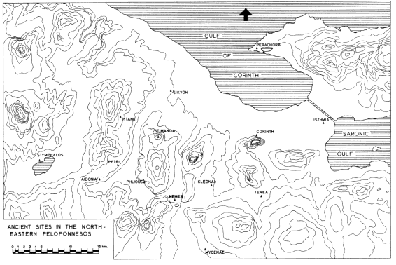
Fig 1.
Map showing the region of ancient Nemea.
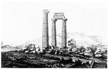
Fig. 2.
The Temple of Zeus from the northeast ca. 1805, with Mount
Daouli in the background; the tumulus in the left background
covers the Basilica, which was discovered in 1924; from
W. Gell, The Itinerary of Greece (London 1810) Pl. 2.
tants, which, like Archaia Nemea, depends for the most part on Nea Nemea (and to a lesser extent on Argos) for its supplies and services. Modern inhabitants of the area (perhaps following ancient practice) go to Corinth only when bureaucratic necessities force a visit to the provincial capital.
The Nemea valley has been almost exclusively agricultural since the 1880s, when a team of French engineers opened the blocked gorge at the northern end, allowing the valley to drain and become arable. The village of Archaia Nemea dates from shortly thereafter. The peaceful atmosphere of the valley is broken occasionally by the noise of an unmuffled tractor or a chain saw and, somewhat less frequently these days, by the more venerable voice of a donkey.