Vegetation on US Army Corps of Engineers Project Levees in the Sacramento/San Joaquin Valley, California[1]
Michael F. Nolan[2]
Abstract.—The US Army Corps of Engineers' involvement with levees for flood control in the Sacramento/San Joaquin Valley is in cooperation with local interests. The integrity of a levee involves many factors, including structural stability and adequate maintenance. Trees and shrubs can be detrimental to the integrity of a levee, although there are opportunities for allowing vegetation on levees.
Introduction
This paper addresses the subject of vegetation on levees in the Sacramento/San Joaquin Valley which are part of Congressionally authorized flood control projects constructed by the US Army Corps of Engineers (CE). Levee design and maintenance criteria are explained, with emphasis on the importance of levee maintenance. Problems with and opportunities for vegetation on levees are presented, along with a discussion of multiple-purpose levees.
An evaluation of erosion control techniques is being made by the CE as part of a nationwide program authorized by the Streambank Erosion Control Evaluation and Demonstration Act of 1974.[3] The use of vegetation for erosion control is being investigated as part of that program, and therefore that subject is not addressed in this paper.
Us Army Corps of Engineers Project Levees
The US Congress in the Federal Flood Control Act of 1936[4] declared a national interest in the prevention of flood damage. The act also set forth requirements for local cooperation. They provided that before any federal funds could be spent for constructing flood control improvements, states, political subdivisions thereof, or responsible local agencies would be required to to give assurances, satisfactory to the Secretary of the Army, that they would: a) provide without cost to the United States all lands, easements, and rights-of-way necessary for the construction of the project; b) hold and save the United States free from damages due to the constructed works; and c) maintain and operate all works after completion in accordance with regulations prescribed by the Secretary of the Army. The CE, on 16 August 1944, issued regulations governing the maintenance and operation by local interests of federal flood control projects.[5] These rules were designed as guides, to obtain a uniform standard of maintenance on all federal flood control projects.
At the request of local interests and with the authorization of the US Congress, the CE cooperates with local interests in planning, design, and construction of flood control projects in the Sacramento/San Joaquin Valley. The State of California has given the assurances required by the Federal Flood Control Act. The assurances are given by the State through the Reclamation Board. The California Water Code sets forth the duties and responsibilities of the Reclamation Board (RB), the California Department of Water Resources (DWR), and public districts and agencies with regard to construction, operation, and maintenance of these projects.
The Sacramento River Flood Control Project and the Lower San Joaquin River and Tributaries Project are two major flood control projects in the Sacramento/San Joaquin Valley which involve extensive levee systems. The extent of these levees is shown in the "Directory of Officials of Flood Control, Reclamation, Levee, and Drainage Districts, and Municipalities" (California Department of Water Resources 1982). Levee construc-
[1] Paper presented at the California Riparian Systems Conference. [University of California, Davis, September 17–19, 1981].
[2] Michael F. Nolan is Supervisory Civil Engineer, Sacramento District, US Army Corps of Engineers, Sacramento, California.
[3] Public Law 93–251 Section 32, as amended by Public Law 94–587, Section 155 and 161, October 1976.
[4] Public Law 738, Section 3 of Flood Control Act of 1936.
[5] Code of Federal Regulations, Section 208.10, Title 33. Flood Control Regulations.
tion on the Sacramento River Flood Control Project was basically completed in 1961, and on the Lower San Joaquin River and Tributaries Project, in 1968.
When local interests obtain land for local protection flood control projects, permanent easements are usually acquired obtaining the right to build, operate, and maintain a levee for flood control purposes. The landowner retains title to the land and all other land rights not encumbered by the easement. The local interest owns the easement and gives the CE permission to enter the land to construct and inspect a levee. For the Sacramento River Flood Control Project and the Lower San Joaquin and Tributaries Project, the RB purchased the flood control easements, although at times it has relied on the prescriptive rights of the responsible levee maintenance district. The local flood control interests have only acquired limited rights, and the landowner still owns the land and all remaining rights.
Levee Design and Construction
CE guidance for design and construction of flood control levees is contained in "Engineering and Design, Design and Construction of Levees" (US Army Corps of Engineers 1978). Levee design includes consideration of flow frequency, duration, and stages; erosion potential; seepage; soils; subsidence; maintenance and inspection requirements; and potential flood fight conditions. The guidance reflects the basic engineering considerations for design and construction of an earth embankment to retain water.
Aesthetics are of special concern from the standpoint of protecting the environment and blending levees with the surrounding environment. Vegetation on levees could serve purposes such as harmonizing a levee project with the surrounding environment, controlling dust and erosion, separating activities, providing privacy or screening of undesirable features, or providing habitat for wildlife. CE guidance on planting levees is contained in "Engineering and Design, Landscape Planting at Floodwalls, Levees and Embankment Dams" (US Army Corps of Engineers 1972) The guidance is to keep the basic levee structure free of roots and to provide a margin of safety of at least 1 m. (3 ft.) between the deepest expected penetration of plant roots and the face of the basic levee structure. If trees and shrubs are desired on a levee, the levee section must be overbuilt to accommodate the plant roots. This basic guidance is depicted in figure 1.
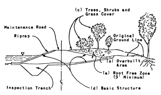
Figure 1.
Cross-sections of an urban levee showing:
a) root-free zone; b) overbuilt area; c) trees,
shrubs and grass cover; d) basic structure.
Vegetation and Levee Maintenance
The detrimental effects of vegetation on flood control levees have been recognized for centuries. Printed below are excerpts from a rare Spanish book, as translated by Amalio Gomez.[6] The book, "Hidrologia Historica del Rio Segura", deals with the struggles of the City of Murcia, Spain, from 1535 to 1879 against floods, droughts, and other calamities.
Murcia Levee Ordinance
1. It is hereby ordained that Murcia's levee shall not be swept by any person, with any type of broom, because the soil of which the levee is built will be blown away by the wind, and in the course of time the levee will lose height. Therefore, he who violates this ordinance shall be fined . . . The city's share [of the fine] shall be used to pay the wage of a levee patrolman.
2. No person shall plant any trees, including mulberry bushes and fruit trees, within ten paces of the toe of the levee, along the entire length of the levee, and on both sides of the levee . . .
3. All trees (see 2. above) located within the ten pace strips described, should be pulled out within thirty days of the publication of this ordinance . . .
4. No person, for any reason, shall farm within the land occupied by the levee with a plow, hoe, or other implement . . .
5. No person shall accumulate a pile of manure within 100 paces of the toe of the levee all along its length . . .
6. It is ordained that no cattle of any kind shall be permitted to walk along the levee crown, with or without an attendant; such cattle must walk the road built parallel to the levee for that purpose. Cattle may cross the
[6] Former Chief, Engineering Division, Sacramento District, US Army Corps of Engineers.
levee only at the paved cattle crossings. Owners of cattle found violating this act shall be fined . . .
7. Grass grown on the levee crown and side slopes shall not be cut or pulled by any person . . .
8. The levee shall not be used as a playground; no person shall damage it by making holes or otherwise. No damage shall be done to any improvements on the levee crown, such as statues, paintings, stone seats, housewalls, stone pavements and hermitages. Violators shall be punished . . . It is further ordained that if the patrolman hired by the city to patrol the levee and enforce these ordinances does not apprehend the violators, he shall be removed from office and appropriately punished. (Gomez 1976)
Each prohibition of the ordinance carried a penalty. The usual procedure was to divide the fine, giving one-third to the judge, one-third to the accuser, and one-third to the city. The ordinance was enacted by the City of Murcia on July 25th, 1737. It was approved by the Royal Council of Castilla, August 30th, 1737.
Corps of Engineers Regulations
The Code of Federal Regulations contains the CE regulations for the operation and maintenance of local flood protection works.[7] These regulations, as written, apply to flood control projects throughout the nation and are of necessity general in character.
With regard to vegetation, the regulations require that measures be taken to promote the growth of sod, exterminate burrowing animals, and provide for routine mowing of the grass and weeds and removal of wild growth and drift deposits. The regulations also encourage planting willows and other suitable growth on the river side of levees to retard bank erosion; they discourage activities which retard or destroy the growth of sod, such as burning grass and weeds.
CE has several regulations which further address vegetation and the operation and maintenance of levees. Excerpts from "Project Operations, Levee Maintenance Standards and Procedures" (US Army Corps of Engineers 1968) are presented below.
Maintenance Standards
The levees will be maintained as necessary to insure serviceability against floods at all times. Standards for accomplishing the foregoing are as follows:
A good growth of sod will be maintained where feasible with grass height from 2 inches to 12 inches, substantially free of weeds.
All brush, trees, or other undesirable wild growth will be removed from the levee embankment. Vegetation specifically planted for aesthetics or recreation purposes may remain.
Maintenance Procedures
Maintaining sod growth—Maintenance of a sturdy sod growth on levee embankments is highly important as sod is one of the most effective means of protecting the levee against erosion from rain, current and wave wash. Periodic mowing is essential to maintaining a good sod growth, and should be done at such intervals as necesssary to keep down weeds and other noxious growth and to prevent the grass height from exceeding 12 inches. The grass should be mowed to a height of 2 inches or more. The number of mowings required each season will depend on local conditions, but experience has indicated that in most parts of the United States two or more mowings are necessary each season where pasturing is not used. The last mowing of the season should be accomplished under conditions which will allow the grass to obtain a height of approximately 8 to 10 inches going into the winter season. Mowing should be performed to a distance of at least 5 feet beyond the toe of the levee or berm.
Burning grass and weeds will not be permitted in the levee maintenance program, except during appropriate seasons when it will not be detrimental to the growth of sod.
"Project Operations, Inspection of Local Flood Protection Projects" (US Army Corps of Engineers 1973) addresses items to look for during inspections. Some excerpts from that regulation are presented below.
Are trees and other growth which might jeopardize the stability or watertightness of the structure removed at regular intervals?
Have trees and undesirable growth been cleared from the levees and along side floodwalls?
Does brush cover or other growth interfere with inspection?
Are there any obstructions to vehicular passage along the crown of the levee?
Is sod cover on levees being encouraged?
Is there any unauthorized burning of grass and weeds?
Is sod cover mowed regularly?
[7] Code of Federal Regulations Section 208.10, Title 33, Chapter II. Part 208—Flood Control Regulations. Corps of Engineers, Department of the Army.
Is sod or other desirable cover fertilized and reseeded as necessary?
Is there an effective program for control of burrowing animals?
"Project Operation, Maintenance Guide" (US Army Corps of Engineers 1967) also contains information on levee maintenance. Appendix I of the regulation, "Inspection Guide and Maintenance Standards," contains the following information:
Close inspection (should be made) for settlement, sloughing, slides, erosion, condition of ground drainage, the presence of burrowing animals, the presence of debris, need of mowing, encroachments that tend to weaken levees, rutting of crown, depressions or other defects.
Keep embankments sufficiently smooth to permit mowing by power equipment. Newly filled areas shall be sodded or seeded.
Levees should be mowed with tractor-operated equipment to a height of 2 inches or more when the grass reaches a height of 5 to 7 inches or when excessive uneven growth of grass or weeds becomes unsightly. Reseeding and fertilizing is limited to kind and weight necesssary to sustain vegetative cover for the control of erosion by wind and water.
Figure 2 is an example of a levee where vegetation interferes with inspection.
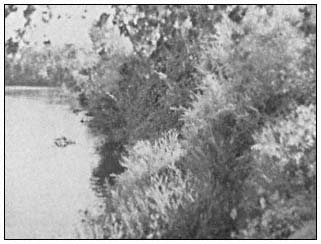
Figure 2.
Levee along Sutter Slough where dense
vegetation interferes with levee inspection.
Title 33 of the Code of Federal Regulations[5] also requires the CE to furnish local interests with an operation and maintenance manual for each flood control project (e.g., US Army Corps of Engineers 1955, 1959). The manual assists the responsible authorities in carrying out their obligations by providing information and advice on the operation and maintenance requirements of each project. Specific maintenance requirements that are applicable to an area are spelled out in special instructions in the manual for each project. This has been done, for example, in the special instructions contained in the "Standard Operation and Maintenance Manual for the Sacramento River Flood Control Project" (US Army Corps of Engineers 1955) which allow burning. Burning was allowed after the California Department of Public Works (DPW) in 1949 contended that due to the nature of the levee vegetation, burning weeds and brush during appropriate seasons should be allowed in order to determine danger to the levee such as slips and cracks and to permit the detection of holes caused by burrowing animals. Figures 3 and 4 present a good comparison between a burned levee and a mowed levee.
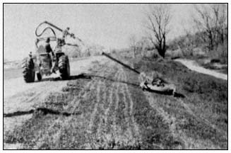
Figure 3.
Tractor-mounted hydraulically operated and controlled rotary
mower as utilized by the American River Flood Control District
(California Department of Water Resources 1973).
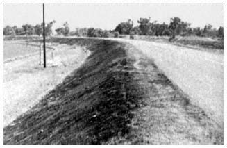
Figure 4.
Burned levee along the Sacramento River near Knights Landing.
Another example of special instructions in the "Standard Operation and Maintenance Manual for the Sacramento River Flood Control Project" (US Army Corps of Engineers 1955) deals with the provision in Title 33[5] which encourages growth
riverward of the levees to retard bank erosion. The special instructions in the manual expand on this provision and allow retention of brush and small trees on the waterward levee slope where desirable for preventing erosion and wave wash. The manual contains the specific requirements for maintenance of each project.
Others besides the CE recognize that vegetation can be detrimental to levees. In December 1954, a year before the disastrous flooding of Yuba City and Nicolaus due to a levee break (fig. 5), the RB and the DPW expressed concern about trees on levees. The following is extracted from an 8 December 1954 letter from the RB to the District Engineer, CE, Sacramento:
The Reclamation Board has through many years of experience found that the existence of trees on the river banks is a serious threat to the integrity of the levee system. In that respect the regulations of the Corps of Engineers require the removal of wild growth from levee banks and this agency is obligated to enforce these regulations. However, the Reclamation Board concurs in the view that trees constitute a menace to flood control works. Tree root systems penetrate levee sections, inducing seepage paths. Trees situated on the edge of the river banks that are uprooted by high winds, particularly when the banks are saturated, create craters in the sandy banks and levee sections rendering both of them susceptible to serious erosion during flood periods. Furthermore, the presence of trees on or adjacent to a levee often seriously interferes with routine maintenance operations such as slope dragging and control of weed cover.[8]
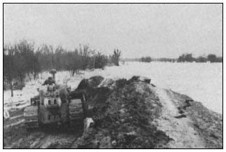
Figure 5.
Break in Feather River levee in Reclamation District 1001.
The following are excerpts from a letter dated 10 December 1954 from the DPW, Division of Water Resources, to the District Engineer, CE, Sacramento:
Through the years, large trees became established on the levee slope and the heavy superimposed load produced slip-outs when the relatively unstable bank and levee section became saturated. Wind action on trees also tends to loosen the embankment and accelerates slippage when moisture is present. Trees overhanging the water's edge tend to pull out and drop into the stream when pressure is released from saturated banks. Trees which are of sufficient size to offer resistance to the flow of water are undesirable in a levee slope. Fallen trees and bared roots caused scour, silting and eventual diversion of the current with the result that banks became undercut, additional trees are dislodged and serious levee slippages ensue.
Best maintenance practice dictates that the levee should be kept clear of trees and brush. However, in actual practice this condition is not fully obtained. In the sand levees below Sacramento, the presence of sod and light growth is not particularly objectionable and, in many instances, considered desirable. However, trees which attain large growth should never be permitted to become established on the levees. At locations where a wide berm exists between the bank of the river and the toe of the levee slope there is no objection to large trees if located in clear of the levee and riverbank.
The assumption that the trees along the banks of the Sacramento River have provided a stabilizing effect is contrary to the experience of the engineers in the Division of Water Resources and others familiar with the conditions along the Sacramento River. Most severe slip-outs in levees of the Sacramento River can be directly attributed to the presence of large trees which place a superimposed load on the relatively unstable embankment, in excess of the ability of the levee material to resist when saturated.[9]
Figures 6 and 7 are examples of some of the problems cited by the RB and the DWR.
[8] California Reclamation Board. 8 December 1954. Letter to the District Engineer, CE, Sacramento, concerning tree removal along both banks of the Sacramento River between Sacramento and Rio Vista.
[9] California Department of Public Works, Division of Water Resources. 10 December 1954. Letter to District Engineer, US Army Corps of Engineers, Sacramento, concerning tree removal along Sacramento River channels downstream from Sacramento.
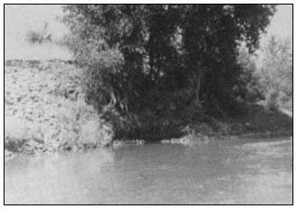
Figure 6.
Exposed roots and erosion around roots of tree
along Sacramento River near Knights Landing.
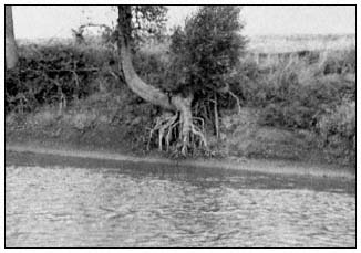
Figure 7.
Exposed tree roots along Sacramento River near Cranmore.
The State maintains some portions of the Sacramento River Flood Control Project under the supervision of the DWR, with costs being defrayed by the State. The DWR also has exercised supervisory powers over maintenance performed by local districts on Sacramento River Flood Control Project levees. Such supervisory controls were accomplished generally in conformance with DWR "Standard Maintenance Procedures" (California Department of Water Resources n.d.) and "Guide for Levee Maintenance" (California Department of Water Resources n.d.). The following is taken from these manuals:
Clearing of the levee slopes of all growth, other than grass, should be accomplished at the earliest opportunity and once cleared the area should be maintained in that condition.
Burning of vegetation on levee slopes and shoulders should be performed annually.
Cut and pile brush, trees, and other obnoxious growths.
Clear brush, trees and wild growth, other than sod, from the levee crown and slopes. Herbicides applied with suitable equipment, under proper control and conditions, have been successfully employed in eradicating pernicious growth of vegetation.
Contrary to the often expressed belief that growth of trees and brush is beneficial for protection of the levee slopes, long experience has demonstrated that this is in error for the following reasons:
Under wind and wave action the larger growths tend to pull at their root systems, causing them to uproot themselves, disturb the soil or rock revetment and permit accelerated erosion to take place. Fallen trees may also cause harmful current deflection and accumulate drift, which can compound the erosive action. Roots of large trees also attract burrowing animals to the protective shelter afforded.
Removal of such growth promotes a growth of sod or grass, the pliable roots of which tend to provide a soil binding net.
Some detrimental effects of vegetation were pointed out again in "Findings and Recommendations Based on the Inspection of the Delta Levees During October 1980" (Department of Water Resources 1980a). Excessive wild growth was considered detrimental because it interfered with visual inspection of levee sections suspected of being inadequate. The DWR recommended some selective clearing to increase the capability for levee inspection and floodfighting.
The importance of levee maintenance has long been recognized. In 1925, in his report to the RB concerning revised plans for the Sacramento River Flood Control Project (California Department of Public Works 1925), the State Engineer stated: "This project will be incomplete and the expenditures largely wasted without adequate provisions for maintenance."
The importance of adequate levee maintenance is also recognized in "California Flood Management: An Evaluation of Flood Damage Prevention Programs" (California Department of Water Resources 1980b), which includes the statements:
Levees are . . . the method [of flood control] with the greatest potential risk of failure . . . Such failure can be caused by high waters overtopping a levee or eroding a portion of a levee, or by excessive seepage through a levee. Also, very large trees can be uprooted, leaving excessive voids in a levee, which can accelerate levee destruction . . . The effectiveness of
any method of structural flood protection depends on the maintenance of the completed projects . . . Levees are the weakest part of a structural flood control program . . . Maintenance is a continuing responsibility with the objective of retaining the functional capability of the structures to store or carry storm flows according to their design . . . Levees are the most critical area in the maintenance of structural flood protection works.
The overriding concern of the CE, Sacramento District, has been ensuring the integrity of the flood control levees. Hence, adequate maintenance must provide a condition which will ensure the integrity of the systems when needed during flood periods. Encroachments which compromise the levee integrity or interfere with inspection, maintenance, and operation activities are detrimental to levee integrity.
Multiple-Purpose Levees
Previous information on levee maintenance was focussed on flood control purposes. Multiple-purpose levees have also been investigated.
On 1 July 1962, the DWR initiated the Pilot Levee Maintenance Study. This five-year study was conducted to conceive and test alternative methods of levee maintenance that would provide for multiple use of levees. In 1967, when the Pilot Levee Maintenance Study (California Department of Water Resources 1967) was completed, all levee maintenance costs were borne by flood control beneficiaries. The results of the study indicated that levee maintenance costs increase significantly when efforts are made to work around and save vegetation. The report on the study included the statement that the introduction of uses other than flood control will require sharing of levee maintenance costs among flood control and the added users in some manner proportional to the value received from multiple-purpose maintenance.
Altering maintenance practices to reflect concerns of other interests was also addressed in the "Preliminary Report to the California State Legislature on a Multiple-Purpose Levee System for the Sacramento-San Joaquin Delta (California Department of Water Resources 1970) and "Sacramento River Levee Revegation Study Final Report, 1968–1973" (California Department of Water Resources 1973). The findings again were that it costs more to maintain levees for multiple purposes, and that some alternative methods of costsharing need to be developed for multiple-purpose levee maintenance.
In 1967, the CE, Sacramento District, approved the adoption of "Levee Encroachment: Guide for Vegetation on Project Levees" (The Reclamation Board 1967) as a guide in the consideration of vegetation encroachments. The Sacramento District recognized fully that vegetation must be most carefully controlled in order to ascertain that the integrity of the levee system is not impaired.
In response to the findings of the DWR, AB 214 (Z'berg) was passed and became effective 1 January 1974. This bill[10] amended the California Water Code[11] to provide financial contributions from the state to local agencies for those costs associated with the operation and maintenance of project levees which are directly attributable to the planting or retention of controlled vegetative cover for wildlife, recreation, scenic, and aesthetic purposes, if the cost of maintenance is increased by such planting or retention. It has already been determined that vegetation was allowed on levees in accordance with the "Guide for Vegetation on Project Levees" (ibid .); this authority provided a method for funding the increased costs associated with preserving the vegetaion. Procedural requirements for this program were developed by DWR (The Reclamation Board 1974). The extent of implementation and funding of this program is unknown to the writer.
Continuous efforts are being made by DWR and RB to find and evaluate alternative construction methods and maintenance practices for flood damage reduction facilities which provide needed flood protection but are also responsive to environmental and aesthetic considerations. Some of these efforts are described in "Flood Control Project Maintenance and Repair 1980 Inspection Report" (California Department of Water Resources 1981).
One such effort involves using integrated pest management. The Center for the Integration of Applied Sciences of the John Muir Institute (JMI) has been working with the DWR since 1976 to develop and implement an integrated pest management program for the flood control levees of the Sacramento River (Center for the Integration of the Applied Sciences 1978). A major pest is the ground squirrel which is believed to weaken the levee structure by its burrowing. In assessing pest problems found on levees, particularly rodent control, the JMI has noted that lack of vegetation may enhance rodent populations. JMI is seeking to develop a vegetative management plan that would discourage rodent populations but not impede the ability of levee maintenance personnel to maintain the physical integrity of the levees. For investigation purposes, JMI selected vegetation which would not serve as a food source for ground squirrels or pocket gophers. JMI has also presented information on the movement of squirrels. Most squirrels remain within 33 m. (100 ft.) of their burrow entrances, although much farther movements have been observed. The ramifications of such selective
[10] Chapter 955, Statutes of 1973.
[11] Chapter 5, commencing with Section 8450, Part II, Provision 5 of the Calfornia Water Code.
plantings could be far-reaching if food sources for rodents are to be kept beyond the limits of the home range of squirrels.
Opportunities for Vegetation
The requirements for levee stability and the detrimental effects vegetation can have on flood control levees have been discussed. After taking these concerns into account, it is possible to outline the conditions under which, without reducing the flood protection provided by the levee systems, vegetation may be allowed on levees in the Sacramento/San Joaquin Valley. Such general guidelines are presented in the "Guide for Vegetation on Project Levees" (The Reclamation Board 1967), approved by CE, Sacramento District, in 1967. The basic guidance is that vegetation must be maintained in a controlled manner to ensure that it does not compromise the levee integrity or interfere with levee inspection, maintenance, operation, or flood-fight activities. The guide requires that the levee be oversized; this overbuilding provides for a root zone. The guide specifies minimum spacing intervals for trees and shrubs, the intent being to keep the levee slopes visible for inspection during low-flow and flood periods. The guide presents acceptable and unacceptable varieties of trees and shrubs—from the viewpoint of growth characteristics, impairment of inspection and maintenance, and potential impairment during flood-fight activities. The guide requires pruning of trees and shrubs so that inspection of the levees is possible.
There are opportunities for vegetation, including trees and shrubs, on project levees in the Sacramento/San Joaquin Valley. Vegetation is allowed, although the extent of vegetation that exists is often determined by the maintaining agencies and the underlying fee owners of the land. In cooperation with the RB, the CE, Sacramento District, has planted some vegetation on and adjacent to levees in the Sacramento/San Joaquin Valley. Where construction has been performed, the construction areas are seeded for dust and erosion control and aesthetic purposes with seed mixes suggested by fish and wildlife interests. Trees and shrubs have been planted where the levee is sufficiently oversized to provide a root zone, and riverward berm areas have also been planted. Figures 8, 9, and 10 show some of the planting that has been done.
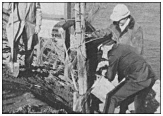
Figure 8.
Planting trees on levee, Sacramento River near Freeport.
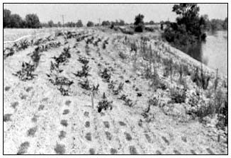
Figure 9.
Various species of vegetation planted along
Sacramento River levee near Elkhorn Park.
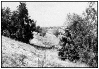
Figure 10.
Trees planted along Sacramento
River levee near Sacramento Weir.
There is presently significant emphasis on having vegetation on flood control levees. However, some levees are not suited to "riparian vegetation", when riparian vegetation is defined as that which requires free or unbounded water or conditions that are more moist than normal (Thomas 1979). Approximately 480 km. (300 mi.) of project levee are adjacent to the Sacramento River between Rio Vista and Ordbend. There are about 10,500 ha. (26,000 ac.) of land within the levee system along the Sacramento River in this reach. The levees occupy about 1,620 ha. (4,000 ac.) of land, the main river channel covers about
2,830 ha. (7,000 ac.), and the remaining 6,070 ha. (15,000 ac.) consist of berms, bars, banks, old oxbow channels and the like. Similar information listed by river reaches between Rio Vista and Ordbend is shown in table 1.
The area available within the levees for wildlife habitat or river aesthetics exceeds the area occupied by the levees almost four-fold. It is recognized that the levees along the Sacramento River downstream of Colusa (River Mile 144) are closely aligned to the main river channel. There are means available, consistent with good flood control practice, for allowing vegetation, including trees and shrubs, on these levees. Where the existing levees are sufficiently oversized, the "Guide for Vegetation on Project Levees" (The Reclamation Board 1967) in conjunction with the program authorized by AB 214 could be used to encourage vegetation on levees. In other areas, the levees could be overbuilt to accommodate such vegetation. Upstream of Colusa, there is ample land within the levees that could be acquired for development of vegetation areas. Such areas would also be better suited to riparian vegetation than the levee embankments which are most often set back from the river. The conditions along the lower San Joaquin River and Tributaries Project levees are similar to those along the Sacramento River levees.
The better levees are maintained, the less likely it is that problems will develop during flood periods; poor maintenance presents a much greater risk of levee failure. Regardless of vegetation, the primary concern in maintaining levees is to assure the flood protection. However, there is a feeling by some that some degree of risk associated with vegetation on levees can be tolerated when considering aesthetics and desires for wildlife habitat. The subject of risking the protection of lives and property that is presently provided by federal flood control projects goes beyond the scope of this paper. However, if such risks are to be taken, the degree of risk should be established and the concurrent liability determined.
| |||||||||||||||||||||||||||||||||||||||||||||
Literature Cited
California Department of Public Works. 1925. Sacramento river flood control project revised plants. 170 p. The Reclamation Board, State of California, Sacramento.
California Department of Water Resources. n.d. Standard maintenance procedures. 7 p. California Department of Water Resources, Sacramento.
California Department of Water Resources. n.d. Guide for levee maintenance. 8 p. Division of Design and Construction, California Department of Water Resources, Sacramento.
California Department of Water Resources. 1967. Pilot levee maintenance study, Sacramento-San Joaquin Delta. Bulletin No. 167, California Department of Water Resources, Sacramento. 24 p.
California Department of Water Resources. 1970. Preliminary report to the California State Legislature on a multiple-purpose levee system for the Sacramento-San Joaquin Delta. 21 p. California Department of Water Resources, Sacramento.
California Department of Water Resources. 1973. Sacramento River levee revegetation study, final rport, 1968–1973. District Report, Central District, California Department of Water Resources, Sacramento. 19 p.
California Department of Water Resources. 1980a. Findings and recommendations based on the inspection of delta levees during October 1980. 23 p. California Department of Water Resources, Sacramento.
California Department of Water Resources. 1980b. California flood management: an evaluation of flood damage prevention programs. Bulletin 199, California Department of Water Resources. Resources, Sacramento. 277 p.
California Department of Water Resources. 1981. Flood control project maintenance and repair 1980 inspection report. District Report, Central District, California Department of Water Resources, Sacramento. 35 p.
California Department of Water Resources. 1982. Directory of officials of flood control, reclamation, levee, and drainage districts, and municipalities. California Department of Water Resources, Sacramento.
Center for the Integration of the Applied Sciences. 1978. Making the transition to an integrated pest management program for ground squirrels on DWR levees. 114 p. Center for the Integration of the Applied Sciences, John Muir Institute, Berkeley, Calif.
Gomez, A. 1976. Hidrologia historica del Rio Segura. Information Bulletin, Sacramento District, US Army Corps of Engineers, Sacramento, California.
The Reclamation Board. 1967. Levee encroachment: Guide for vegetation on project levees. 4 p. California Department of Water Resources, Sacramento.
The Reclamation Board. 1974. Joint interim procedures for the administration of a state program of financial assistance for maintenance of controlled vegetation on project facilities. 9 p. California Department of Water Resources, Sacramento.
Thomas, J.W. (ed.). 1979. Wildlife habitats in managed forests: The Blue Mountains of Oregon and Washington. USDA Forest Service Agricultural Handbook No. 553, Washington, D.C. 512 p.
US Army Corps of Engineers. 1955. Standard operation and maintenance manual for the Sacramento River flood control project. 32 p. plus 62 supplements. South Pacific Division, Sacramento District, US Army Corps of Engineers, Sacramento, Calif.
US Army Corps of Engineers. 1959. Standard operation and maintenance manual for the lower San Joaquin River levees, Lower San Joaquin River and Tributaries Project, California. 32 p. plus 13 supplements. South Pacific Division, Sacramento District, US Army Corps of Engineers, Sacramento, Calif.
US Army Corps of Engineers. 1967. Project operation, maintenance guide. Engineering Regulation 1130-2-303. Department of the Army, Office of the Chief Engineer, Publications Depot, Alexandria, Va.
US Army Corps of Engineers. 1968. Project operations, levee maintenance standards and procedures. Engineering Regulation 1130-2-335. 4 p. Department of the Army, Office of the Chief Engineer, Publications Depot, Alexandria, Va.
US Army Corps of Engineers. 1972. Engineeering and design, landscape planting at floodwalls, levees and embankment dams. Engineering Manual 1110-2-301. 10 p. Department of the Army, Office of the Chief Engineer, Publications Depot, Alexandria, Va.
US Army Corps of Engineers. 1973. Project operations, inspection of local flood protection projects. Engineering Regulation 1130-2-339. 9 p. Department of the Army, Office of the Chief Engineer, Publications Depot, Alexandria, Va.
US Army Corps of Engineers. 1978. Engineering and design, design and construction of levees. Engineering Manual 1110-2-1913. 180 p. Department of the Army, Office of the Chief Engineer, Publications Depot, Alexandria, Va.