Flood Control and Riparian System Destruction
Lower San Lorenzo River, Santa Cruz County, California[1]
Gary B. Griggs[2]
Abstract.—A 1959 flood control project on the lower San Lorenzo River in Santa Cruz County, California, involved levee construction and excavation below the river's natural grade. Subsequent siltation has greatly reduced the channel's capability to contain flood waters. Annual dredging has destroyed the riparian corridor and has not significantly increased flood protection.
Introduction
The San Lorenzo River drains 357 km2 of the central California Coast Ranges (fig. 1). Annual rainfall in the redwood-forested basin averages 150 cm., and flooding has been common within the communities which occupy the river's floodplain. Steep slopes, landslides, and unstable soils combined with high-intensity precipitation have led to severe erosion in certain parts of the basin. Logging, quarrying, and the grading and vegetation removal that accompany urban and rural developments have compounded the erosion and sediment-production problem.
Excluding the population of the city of Santa Cruz at the river's mouth, the watershed is home to 33,000 people. Most of the population is concentrated along the stream bottoms of the river and its tributaries.
As a result of disastrous flooding within the city of Santa Cruz during December 1955, the US Army Corps of Engineers (CE) proposed a flood-control project along the lower San Lorenzo River. The project consisted of levee construction and channel dredging for 4 km. upstream from the river mouth. Changes in channel equilibrium have produced heavy siltation which has greatly reduced the project's flood control capacity. For the past four years the city has annually removed all river-bottom vegetation and bulldozed the accumulated sediment into windrows in the hope that the river would scour out its bed. Scouring has not taken place, but loss of riparian system has occurred.
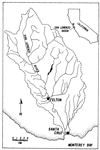
Figure l.
Index map showing the San Lorenzo River
watershed and its location in California.
Flooding
Flooding is the most widespread geologic hazard in the United States, accounting for greater annual property loss than any other single hazard. Despite the construction of ever-increasing numbers of dams, channels, and levees for "flood control" purposes, losses from flooding have continued to increase primarily due to expanded use, re-occupation, and development of downstream floodplains.
There is little doubt that river control works accelerate floodplain development. Once a sense of security from flooding has been established, the conversion of open space to densely populated areas has become commonplace. Although flood control projects do offer protection from all events smaller than the design flood, if properly designed, they will not be effective against the infrequent larger events. In other words, all flood control ends somewhere; we simply cannot afford to provide protection from the 500- or 1,000-year flood. Thus, as "protected" floodplain areas are more intensively developed, the potential damage from a great or catastrophic flood, which cannot be contained, continues to rise.
Developments located in the floodplain are not only more susceptible to damage, but also reduce the capacity of the floodplain to transport and store floodwaters, and may actually increase the depth and areal extent of inundation. Virtually the entire downtown portion of Santa Cruz lies within the 100-year floodplain of the San Lorenzo River, as do certain residential areas along the river's upper reaches.
Logging and land clearing activity can contribute to flooding problems. Logjams can form as logs and other debris are swept downstream during high flows. Considerable damage during past floods in the densely wooded and heavily logged San Lorenzo basin was apparently caused by logjams occurring at bridges, followed by river back-up and over-bank flooding.
Continued heavy rainfall during December, 1955, led to severe flooding throughout the San Lorenzo basin. Fifty centimeters of rain fell between 15 and 28 December at Boulder Creek, with almost half of that (23 cm.) falling on 22 December. The gauging station at Big Trees in Felton recorded a 6.88-m. stage with a discharge of 861 cu. m. per second (30,400 cfs). Overflow occurred from the headwaters to the mouth, resulting in the maximum flood on record. Numerous logjams and other channel obstructions diverted the floodflows, causing streams to change from their normal alignments and undercut and scour out numerous bridges, road fills, and private developments (US Army Corps of Engineers 1973). Seven persons lost their lives, 2,830 people were displaced from homes, and damages amounted to $8.7 million; most of this was within the city of Santa Cruz itself.
Flood Control
Almost two years before the 1955 flood, in the spring of 1954, the CE applied to Congress for $2.265 million for the construction of a flood control project on the lower 4 km. of the San Lorenzo River and lower Branciforte Creek in the city of Santa Cruz (fig. 2). Preliminary designs had already been completed using discharge from a 1940 flood.
The December 1955 flood apparently interrupted work and necessitated a re-evaluation of the "standard project flood" (the 150-year event), but it also provided the CE with even stronger justification for proceeding with the project. Construction began in 1957, after the following revisions in the discharge capacities of the project: a 25% increase for the San Lorenzo, and a 110% increase for Branciforte Creek, to 1,303 cu. m. per second (46,000 cfs) and 238 cu. m. per second (8,400 cfs) respectively (US Army Corps of Engineers 1957).
The CE project consisted of the construction of levees for 4 km. upstream from the mouth, and the excavation of about 590,000 cu. m. of sediments from the existing channel, to increase the slope and capacity of the new channelized reach. The "design" channel bottom was lowered as much as 2.1 m. below the natural or original river-bottom (fig. 3). In conjunction with the excavation, the CE design utilized flow velocities of 2.4–7.5 m. per second (7.9–24.7 ft. per second) to move the necessary water volumes through the various design cross sections.
In July of 1959 the project was completed and was deeded to the City of Santa Cruz by the CE. The city agreed to maintain the channel to design specifications and was provided with a maintenance plan and procedure. Annual maintenance costs were estimated by the CE at $25,000. Total project cost at the time of completion was $6,466,000. The CE departed at this point, absolved of all further responsibility. Considering the awesome reputation of the CE and the docile mentality of the times, it is not surprising that no one questioned the wisdom of dredging the channel and altering the gradient, the velocities used in the design, or the size of the channel. Because the CE presumably had the most experience in the field, it was assumed that the project as planned was the best long-term solution.
Flood protection assured, Santa Cruz intensively redeveloped the "former" floodplain of the
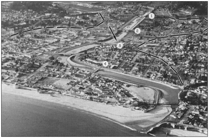
Figure 2.
The city of Santa Cruz and the San Lorenzo River Flood Control Project in 1971. Dashed line delineates
the floodplain. Numbers refer to individual bridges—1) Highway 1, 2) Water Street, 3) Soquel Avenue,
4) Riverside Avenue. Arrow indicates point where Branciforte Creek enters San Lorenzo River.
now-tamed San Lorenzo River over the next 10 years. A shopping mall became the showpiece of a downtown renovation project. The early 1970s, however, brought some threatening revelations about the safety of downtown Santa Cruz and the condition of the channel. A 1975 channel centerline survey showed that at least 306,000 cu. m. of sediment had accumulated, significantly reducing the project's capacity. Annual dredging to project depth was not performed by the city, as public works officials felt that high winter flows would scour the accumulated sediments out to sea.
In an effort to aid this process, the city began to utilize a bulldozer with ripper blades to uproot all river-bottom vegetation along the entire 4-km. length of the flood control project, believing that the roots held sediment in place, thereby preventing scour. Scour, however, still did not occur. Subsequent surveys have shown only minor variation in the amount of channel fill, which now stands at about 350,000 cu. m. (figs. 3 and 4).
The California Department of Water Resources (DWR) discovered the situation in 1976. DWR threatened to assume responsibility for clearing the channel and charge the City of Santa Cruz for the dredging later. Responding to these official warnings, the city began to bulldoze sediment up into windrows within the last four years, again, hoping for winter scour to remove the sand (fig. 5). The city also started to remove sediment on a small scale; as of June 1981 less than 40,000 cu. m. had been removed. This has led to nearly total destruction of the riparian vegetation on an annual basis, as well as an unsightly downtown river channel. However, the city is unable to
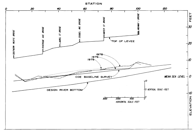
Figure 3.
Changing gradient of the San Lorenzo River as it passes through Santa Cruz. Note the contrast between
original or design river bottom after dredging and surveys taken in the late 1970s. Baseline survey refers
to channel condition prior to commencement of flood control project in 1959. Station numbers refer to
distance upstream from the river mouth in hundreds of feet (Station 20 = 2,000 feet).
finance the total removal of the accumulated sediments, with the cost estimated to be as much as $3 million initially and at least $200,000 annually to maintain. These are considerably different figures (even allowing for inflation) than the CE estimated in 1959 ($25,000/year). As a result, the city is concerned both about the cost of removing sediment and the potential flood hazard of leaving the sediment in the channel.
With no scouring during a large storm, it has been determined that some individual cross sections could only contain the 25- to 30-year flood. This is of immediate concern because the city is now hydrologically, as well as legally, back within the 100-year floodplain, as it was prior to the construction of the "flood control" project. No federal monies should thus be available for projects in the area; flood insurance coverage is also in question. Santa Cruz is stuck with a poorly designed project, a difficult dilemma, and a financial and ecological disaster. Why has this happened? Are there any solutions? And can we learn something from this expensive mistake?
The Effect of Altering the Natural Channel Gradient
Stream equilibrium is a dynamic process that is continually reacting to changing hydraulic conditions and basin sediment production. Water velocity, channel slope, and sediment transport capacity are adjusted in response to variations in discharge, channel morphology, and sediment availability.
In removing 590,000 cu. m. of sediment during construction of the flood control project,
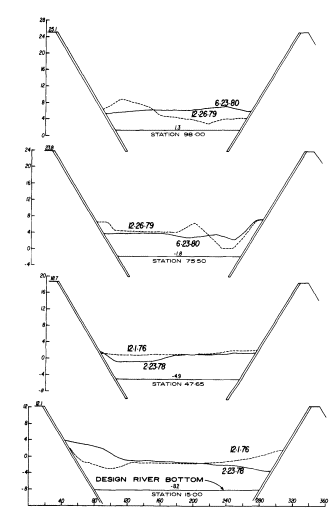
Figure 4.
Selected channel cross sections along San
Lorenzo River in Santa Cruz showing extent
of channel fill above original design channel
bottom. Station locations refer to Figure 3. All
elevations are in feet relative to mean sea level.
the CE increased the channel slope 32% over its last 4 km. and upset the equilibrium conditions established over thousands of years. Sea level is the ultimate base level for the San Lorenzo and most other rivers; however, due to channel excavation, high tides could extend 4 km. inland to the Highway 1 bridge. During a spring tide of 2 m. (mean sea level), 1.7 m. of standing water would occur at the bridge.
The anticipated hydrologic response of flowing water upon entering a standing body of seawater would be a reduction in velocity with accompanying deposition of sediment load. The "improved" channel was actually a sink that would eventually be filled in with sediment from the watershed, much like a dam or reservoir traps sediment. This process would continue until the channel returned to an equilibrium slope. Periodic surveys of the channel centerline and various cross sections indicated that equilibrium was gradually reestablishing, and it has now been reached.
However, the new equilibrium channel has a different profile than either the original or the design channel in the reach between Soquel and Highway 1 bridges (see fig. 3). The increased channel width and an increase in river sediment load have created a new equilibrium gradient in this reach. The channel bottom is now 2 m. above the initial design bottom and 0.9–1.2 m. above the original natural channel.
The estimated quantity of sediment that must now be removed in order to restore the design channel is about 350,000 cu. m. The CE made no mention of deposition problems in their design manual except to note frequent dredging would be required to maintain the channel grade. Effects of the sediment removal on the river's aquatic system and riparian vegetation were also not discussed. The basis for the CE estimate of annual dredging cost is unknown, but no sediment discharge measurements from the watershed had been made at the time the project was initiated.
Sediment Yield and Transport
Sediment yield within the San Lorenzo watershed is high and volumes of material transported by major runoff events can be very large. The natural basin conditions (steep and unstable slopes, highly erodible soils, and high intensity precipitation) combined with the vegetation removal and soil disturbance accompanying logging, quarrying, road-building and construction activities have all contributed to high erosion rates and the production of large volumes of sediment. Much of the construction and population growth in the watershed (the population tripled from 1960 to 1979, from 11,600 to 33,000 people) has occurred in areas with soils which are particularly erosion-prone. The San Lorenzo River Watershed Management Plan estimates that the two- to four-fold increase in sediment production during these years is directly attributable to human disturbance of the basin's soils.
Suspended sediment and limited bedload measurements have been intermittently collected at two stations within the basin since 1973. Using the sediment transport curves, flood frequency distribution, and particle size breakdown, projections can be made for the magnitude of sediment transport under various flood conditions as the river passes through
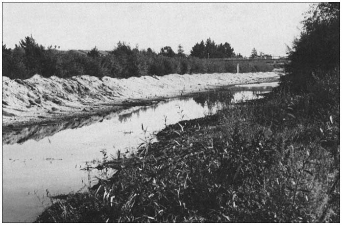
Figure 5.
San Lorenzo River channel immediately downstream from the Water
Street bridge showing efforts by the City of Santa Cruz Department of
Public Works to pile up sediment in hopes of flushing by high flows.
Santa Cruz (table 1). For example, the 10-year flood can carry over 800,000 metric tons per day (520,000 cu. m.) of sand-sized or larger material in suspension. Bedload would increase this by 5% to 10%. If a sink (as was created in the "flood control" project) or tide water was encountered by material of this size in transit, it seems probable that much of it would be deposited. Again, although flood conditions would not normally persist for 24 hours, even eight hours of the 10-year storm could produce 173,000 cu. m. of sediment. Significant volumes of sediment can be transported by the two- or five-year events. Even if the channel were to be dredged to original project design, sediment carried by one large floodflow (or even the cumulative effect of several years of moderate flow conditions) could soon fill the channel back to an equilibrium grade. This raises serious questions about the effectiveness of annual dredging as a solution to the flood control problem.
The unavoidable conclusions are the following. 1) The San Lorenzo River channel is now at equilibrium grade, and the sediment fill appears from all evidence to be stable. 2) The channel can no longer carry the 100-year event, and in fact cannot, in all probability, hold the 30- to 40-year flood. 3) Downtown Santa Cruz is endangered and has far less protection than is required by the Federal Flood Insurance Act. The $6.5 million flood control project designed by the CE grossly underestimated the sediment load being carried by the river and also failed to account for the changes in channel equilibrium gradient which would be produced by the alteration of channel morphology.
| ||||||||||||||||||||||||||||||||||||||||
Future Options
There are no simple solutions to the flood hazard which the city of Santa Cruz is currently faced with, but any solution clearly involves the riparian corridor and the life it supports and the natural beauty it can present. This problem is not unique to Santa Cruz and the San Lorenzo River, but develops anywhere major "flood control" projects have been carried out. Through dams and reservoirs, aquatic systems are totally flooded; through "channel improvements" (levees, dredging, and channel straightening) these same systems are destroyed or eliminated, temporarily if not permanently. Thus, the price of flood control using engineering works is riparian corridor elimination in most cases. The San Lorenzo River is an extreme example in that the annual river-bottom vegetation removal and sediment shuffling has not even produced the anticipated protection from flooding.
Two important factors to consider in any proposal dealing with Santa Cruz and the San Lorenzo River are: 1) is the solution permanent and does it deal with the root cause, or is it simply a temporary stopgap approach; and 2) how will it ultimately affect the riparian corridor?
We invariably select engineering rather than planning solutions because these are more visible, more impressive, and they are also driven by institutional inertia. In addition, once the engineering structure is in place, additional engineering is the usual solution to shortcomings or flaws in the original design. (The reality is, however, that large natural systems, such as rivers and the ocean, simply can never be totally controlled by man-made structures).
A number of possibilities exist or have been proposed.
Option l.—Dredging and removal of all the accumulated sediment from the channelized reach of the river would cost about $3 million today. Although this would reduce the immediate flood threat to the city, it would offer only temporary protection. At average annual sand transport rates of 40–80,000 cu. m., either channel capacity would soon be reduced or expensive (estimated $100–200,000) yearly dredging would be required, thereby producing annual riparian corridor destruction. The city currently is using this dredging approach, but has only been removing sediment from the channel on a very modest scale. Channel surveys indicate that upstream sand input from winter flows is keeping pace with the sand removal operations.
Option 2.—A combination of erosion control measures and sediment or debris basins could be used to reduce downstream sediment transport in the San Lorenzo River. This effort would have to be accompanied by initial dredging of the channel reach through Santa Cruz in order to provide the required flood protection. Although any erosion control measures in the watershed would be beneficial, the costs of land acquisition and maintenance, and biological effects of a number of large sediment traps on the San Lorenzo River or major tributaries are serious negative factors. For comparison, costs for 20 such structures, each impounding one square mile watershed, would approximate the initial outlay and annual costs of maintaining the downtown channel.
Option 3.—A single large dam on the San Lorenzo itself or several smaller dams on major tributaries could reduce flood peaks by 20,000 cfs, such that the present channel could convey the reduced floodflows. No suitable site exists on the San Lorenzo for a dam of this sort without producing major inundation of populated areas. Construction costs and environmental impacts of the number of smaller dams required make this alternative an unattractive one.
Option 4.—The levees and bridges could be raised in order to increase the channel capacity such that the 100-year flood could be effectively contained. This option essentially enables the channel gradient to remain at its equilibrium position and allows for increased flood capacity
through raising the banks. The costs for the replacement of four bridges and a six-foot increase in levee heights is estimted to be $20 million, over three times the cost of the original project (Jones-Tillson and Associates 1979). Any engineering solution of this sort has an obvious economic limitation, and the 100-year flood may well occur and top the banks despite the expenditure of $20 million. Should a flood large enough to breach the levees occur, the height of the floodwaters above the channel floor would provide a hydraulic head that could quickly erode the levee and inundate downtown Santa Cruz.
Perhaps the all too obvious solution is not to have built our cities on floodplains to begin with. History is against us however, and it is senseless to blame our ancestors for settling on the fertile flatlands adjacent to our rivers and streams. Although it may be cheaper and safer in the long run to relocate many floodplain communities, this is unlikely to ever occur without the occurrence of major floods which totally destroy those communities.
A compromise of sorts may be obtained by allowing a river to develop some sort of natural course, within the broader confines of a flood control structure. In the case of the San Lorenzo, a width increase of 18–34 m. would increase the channel capacity to original design conditions (approximately accomodating the 100-year flood). This proposal presents some challenges and opportunities in allowing the river to reconstruct some of its natural meanders and retain its natural gradient (both eliminated by the present levee system).
Utilizing a meandering pattern would only require rebuilding one of the levees at any particular location. A survey of land adjacent to the river shows that streets, parking lots, used car lots, parks, and tennis courts occupy much of the 18 to 34 m. of land in question. These uses could be continued after excavation occurs. The widening of the river could be designed such that a smaller pilot channel could hold perhaps the five- to 10-year event. Much of the remaining channel could be vegetated as a downtown park and green belt such as the recessed park which presently exists between Soquel and Water streets adjacent to the river. Other higher floodplain land could be used for the previously mentioned parking and streets except during and immediately after major flood events. The pilot channel could also provide an adequate flow depth for anadromous fish migration.
Existing bridges could probably be extended, obviating the complete bridge replacements necessitated by Option 3. Some houses and small commercial buildings may have to be removed, but initial investigation indicates that displacement need not be extensive. Much of the required land is city property which would lower acquisition costs.
Conclusions
In any attempt to control a natural system, we must realize that we are usually going to disturb a delicate equilibrium. By excavating the San Lorenzo River's bed to increase its slope and capacity to transmit floodwaters, we also created a disequilibrium to which the river had to adjust. As a result of the river aggrading its channel back to an equilibrium gradient, flood control capacity has been significantly reduced. Because the channel can no longer contain the 100-year event, the entire downtown area of Santa Cruz is apparently no longer covered by the Federal Flood Insurance Act. The stopgap bulldozer approach presently being used has led to yearly destruction of the riparian corridor and no significant alleviation of the flood hazard.
We must begin to focus our efforts on controlling our own activity, rather than persisting in the ineffective historical approach of an increasingly expensive system of dams, levees, and channels. All flood protection ends somewhere. We can never afford complete flood protection, as a community, a state, or a nation. The continued increase in annual flood losses despite the construction of an ever-increasing number of "flood control" structures is clear testimony to the failure of this approach.
Literature Cited
US Army Corps of Engineers. 1973. Flood plain information—San Lorenzo River, Felton to Boulder Creek. US Army Corps of Engineers, San Francisco, Calif.
US Army Corps of Engineers. 1957. General design memorandum—San Lorenzo River flood control project. US Army Corps of Engineers, San Francisco District, San Francisco, Calif.
Jones-Tillson and Associates and Water Resources Engineers. 1979. San Lorenzo River reconnaissance study. US Army Corps of Engineers, San Francisco, Calif.