Location and Description
The gap between Mount Aigaleos and Mount Parnes is the widest pass giving access to the plain of Athens from the direction of the Corinthian Isthmus and the Kithairon frontier of Boiotia. Like the more narrow pass of the Sacred Way to the south, it provides a way to the plain of Athens from the plain of Eleusis on the west side of Aigaleos. The distance between the slopes of Aigaleos and Parnes is almost two kilometers at the narrowest part of the pass, but free movement within it is restricted by two lines of hills that rise at its narrowest point and run to the southwest, into the lower plain of Eleusis. These two lines of hills form three saddles within the pass, and through these saddles run most of the paths and modern routes using the pass, including, in the southern
saddle, the single overland railway line linking northern Greece to the Peloponnese.
The Dema wall runs northward from the northern slopes of Aigaleos, across the two hills standing in the narrows of the pass, and up the slope of the southernmost outrunner of Parnes, covering a total distance of some 4,360 meters as measured on the ground (see map 2 and figure 9).[2] The wall keeps just west of the summit of the pass, following a meandering course carefully chosen so as to leave no higher ground and a minimum of level ground before it to the west. In many places the line of the wall is drawn across the brow of a hill, leaving the steepest slopes in the area directly in front of it. The course of the wall provides a balance between the shortest line across the pass and the maximum advantage of position for a defender facing an enemy coming from the west.
Two distinct sectors of the Dema wall can be recognized on the basis of construction technique and form. The principal and more substantially built sector crosses the pass from its beginning on Aigaleos at the south to the foot of Parnes at the north, a ground distance of 2,950 meters. The second and more slightly constructed sector continues the line of the wall in a northwesterly direction up and along the slopes of Parnes, over a distance of 1,410 meters.
In its principal, or southern, sector, the face of the wall is built of a rough-worked masonry varying from a near-rubble polygonal style to horizontal courses of roughly rectangular and trapezoidal blocks, often with irregular fillers and stackwork (see figures 12-16). Behind this facing, the fill of the wall is rubble mixed with earth and stone chips. The stone for construction was quarried on the spot from the local gray limestone bedrock, atop which the wall is directly founded over most of its length.
The principal sector of the wall is not a continuous barrier but is composed of separate wall-sections built with finished ends. These sections overlap each other, the northern end of each advanced just to the west of the beginning of the following section, leaving a small gap which forms a sally port. These sally ports, averaging about a meter in width, open toward the north, or toward the right from the point of view of someone standing behind the wall. Where the Dema crosses sloping ground, the interval between sally ports is greater (an average of 65 meters); where it crosses level ground, they occur more frequently (at an average of 29-meter intervals).[3] The form of the wall-sections also varies according to whether they run across sloping or level ground. Over sloping ground,
[2] This measurement and those given below are provided by DEMA 156.
[3] The average lengths are derived from the measurements given by DEMA 167 note 25; cf. also 159.
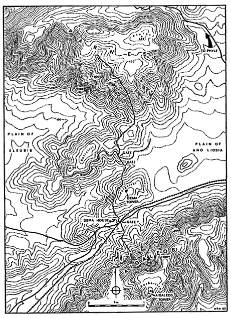
Map 2.
The Dema wall in the Aigaleos-Parnes gap
the longer sections are less than 2 meters wide, with their top surface about 1.50 meters above ground level in front, while in back, a rubble fill forms a ramp running the entire length of each section, rising from ground level some 3 meters behind the wall to give access to its fiat top surface (see figure 10). Over level ground, the shorter wall-sections are more massive, being nearly 3 meters in width and 2 meters or more in height, with access to their top surfaces provided by pairs of separately built ramps averaging 2.75 meters wide by 5 meters long behind each section (see figure 11). The ramps indicate that the top of the wall was meant to be used as a fighting platform, a fact that is confirmed by the remains of a breastwork or parapet wall about 0.60 meters wide preserved atop the outer face on some wall-sections of each type.
In addition to sally ports, at least two wider gateways (between 2 and 3 meters wide) were built into the wall. Both of these are located near the center of the pass. The southern of the two was built a little way above the bottom of the central valley, where it served a natural way through the pass by way of the central saddle. The second was built 230 meters to the north, where it served a terraced road that begins east of the wall and runs for some distance to the west, at a uniform elevation, along the ridge called Kalistiri. Other stretches of terraced road, apparently related to the first stretch but not continuous with it, lie at lower levels along the northern slope of Kalistiri. It is likely that there was a third gate in the wall in the southern saddle, since this was probably always the most-traveled route through the pass. Here the railroad and the paved highway, following the line Of the main track of the nineteenth century, both cross the line of the wall. An original gateway here would have been obscured by the traffic of the ages and by the robbing of stone that evidently took place along this easily accessible stretch of the Dema wall. Any traces of it that may have survived to the nineteenth century have been destroyed by either the construction of the railroad or the highway.[4]
The state of preservation of the wall in its principal sector is generally good. Over most of its length, the wall stands to approximately the original height of the walkway atop each of the wall-sections. Damage to the wall has naturally been greatest wherever it is directly accessible to everyday traffic, and this is especially the case where the wall crosses the south-
[4] On the preserved gateways and the road on Kalistiri, see DEMA 162-63 and figure 4 p. 158. The gate in the central saddle has now been destroyed (see note 5 below). On the possibility of a gate in the southern saddle, see Dow 1942, 200, and DEMA 159 note 4, 161, 169, and note 37; cf. also "Dema House" 75, 105, 114, and figure 2, p. 82, on the relationship of the Dema house to the probable route that such a gate would have served.
ern saddle. Within recent years, the great increase in industrial activity in the area has led to further encroachments upon the wall, but as of 1987, this damage has not been particularly widespread.[5]
The second, or northern, sector of the Dema wall seems quite crude by comparison to the southern sector, and there are some anomalous features in the transition between the two. Near the center of the northern saddle, the last independent wall-section of the southern sector deviates from the norm in that both of its ends stand to the west of the adjacent stretches of wall, leaving an irregular, southward-facing sally port at its southern end. This section is also peculiar in that it combines the construction and features of the shorter wall-sections in its southern half with those of the longer sections in its northern half, and is incomplete in that there is no rubble ramp heaped up behind the longer northern part of this section.[6] After an offset sally port of the regular type at the northern end of this section, the wall continues as a less substantial rubble structure, less than a meter in height and without a backing ramp. This wall gives out after 37 meters and is traceable only intermittently for some distance thereafter as a line of stones on the ground. When the remains of the wall become more substantial, they can be followed as they gradually climb northwestward and traverse the steep slopes of Parnes in an almost straight line, eventually coming to an end at a seemingly arbitrary point. The remains are those of a simple wall of unworked rubble, about a meter in width and no more than that in preserved height; it was clearly never more than a low parapet or breastwork (see figure 19). This sector has no sally ports or gateways, and its nearly straight course displays none of the attention to local terrain shown in the southern sector. It gives the impression of hasty work, especially when contrasted with the apparent care taken in the planning and construction of the southern sector.
[5] On damage to the wall in the southern saddle as of 1955, see DEMA 160-61, with notes 7 and 8; on other disturbances to the wall, see DEMA 171. As of 1977, landfill associated with one of the city dumps of Athens had completely covered the wall in the southern saddle north of the railroad, and the Dema house along with it (this landfill had begun accumulating by spring of 1962; see "Dema House" 75 note 2a). Work at a large quarry south of the railroad and immediately east of the wall has caused some incidental damage to the wall on the lower slopes of Aigaleos, while further upslope on Aigaleos, the quarry workers have for some reason cleared rubble away from the front and back of the wall, with the result that much of the original rubble ramps backing the wall here has been removed. Other damage between 1955 and 1977 includes the destruction of the gate in the central saddle by a bulldozed road and the destruction of slight traces of the wall in the northern saddle, at the foot of Parnes, by bulldozing associated with the construction of power pylons and by the construction of the Mornos aqueduct.
[6] The peculiarities of this wall-section are best appreciated in plan; see DEMA figure 3 IV, wall-section 49-50, and cf. the description on p. 163.