Two
The Dema Wall, Form and Function
The survey by Jones, Sackett, and Eliot remains the authoritative description of the Dema wall, to be emended occasionally on points of interpretation, rarely of observation. For a detailed description of the wall, the reader is referred to that study, which is all the more invaluable because it was made before industrial works and landfills began obscuring and destroying portions of the wall in the past few decades. What follows is a description of the general nature of this fieldwork and some of its distinctive features, a discussion of those archaeological features most indicative of its date, and an analysis of its function as indicated by its form.[1]
Location and Description
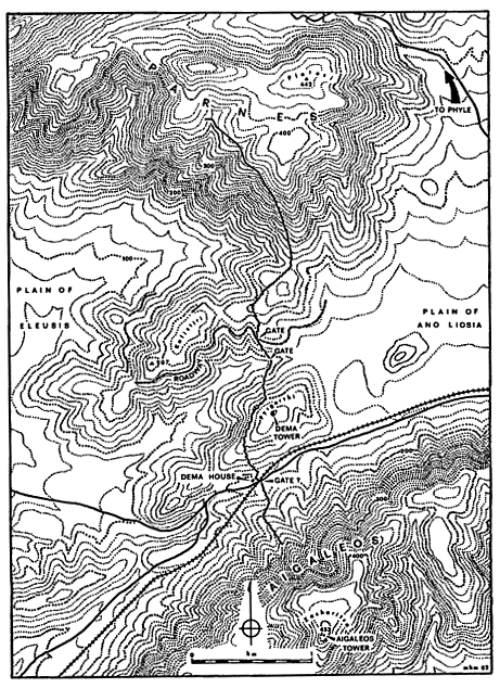
The gap between Mount Aigaleos and Mount Parnes is the widest pass giving access to the plain of Athens from the direction of the Corinthian Isthmus and the Kithairon frontier of Boiotia. Like the more narrow pass of the Sacred Way to the south, it provides a way to the plain of Athens from the plain of Eleusis on the west side of Aigaleos. The distance between the slopes of Aigaleos and Parnes is almost two kilometers at the narrowest part of the pass, but free movement within it is restricted by two lines of hills that rise at its narrowest point and run to the southwest, into the lower plain of Eleusis. These two lines of hills form three saddles within the pass, and through these saddles run most of the paths and modern routes using the pass, including, in the southern
saddle, the single overland railway line linking northern Greece to the Peloponnese.
The Dema wall runs northward from the northern slopes of Aigaleos, across the two hills standing in the narrows of the pass, and up the slope of the southernmost outrunner of Parnes, covering a total distance of some 4,360 meters as measured on the ground (see map 2 and figure 9).[2] The wall keeps just west of the summit of the pass, following a meandering course carefully chosen so as to leave no higher ground and a minimum of level ground before it to the west. In many places the line of the wall is drawn across the brow of a hill, leaving the steepest slopes in the area directly in front of it. The course of the wall provides a balance between the shortest line across the pass and the maximum advantage of position for a defender facing an enemy coming from the west.
Two distinct sectors of the Dema wall can be recognized on the basis of construction technique and form. The principal and more substantially built sector crosses the pass from its beginning on Aigaleos at the south to the foot of Parnes at the north, a ground distance of 2,950 meters. The second and more slightly constructed sector continues the line of the wall in a northwesterly direction up and along the slopes of Parnes, over a distance of 1,410 meters.
In its principal, or southern, sector, the face of the wall is built of a rough-worked masonry varying from a near-rubble polygonal style to horizontal courses of roughly rectangular and trapezoidal blocks, often with irregular fillers and stackwork (see figures 12-16). Behind this facing, the fill of the wall is rubble mixed with earth and stone chips. The stone for construction was quarried on the spot from the local gray limestone bedrock, atop which the wall is directly founded over most of its length.
The principal sector of the wall is not a continuous barrier but is composed of separate wall-sections built with finished ends. These sections overlap each other, the northern end of each advanced just to the west of the beginning of the following section, leaving a small gap which forms a sally port. These sally ports, averaging about a meter in width, open toward the north, or toward the right from the point of view of someone standing behind the wall. Where the Dema crosses sloping ground, the interval between sally ports is greater (an average of 65 meters); where it crosses level ground, they occur more frequently (at an average of 29-meter intervals).[3] The form of the wall-sections also varies according to whether they run across sloping or level ground. Over sloping ground,
[2] This measurement and those given below are provided by DEMA 156.
[3] The average lengths are derived from the measurements given by DEMA 167 note 25; cf. also 159.
Map 2.
The Dema wall in the Aigaleos-Parnes gap
the longer sections are less than 2 meters wide, with their top surface about 1.50 meters above ground level in front, while in back, a rubble fill forms a ramp running the entire length of each section, rising from ground level some 3 meters behind the wall to give access to its fiat top surface (see figure 10). Over level ground, the shorter wall-sections are more massive, being nearly 3 meters in width and 2 meters or more in height, with access to their top surfaces provided by pairs of separately built ramps averaging 2.75 meters wide by 5 meters long behind each section (see figure 11). The ramps indicate that the top of the wall was meant to be used as a fighting platform, a fact that is confirmed by the remains of a breastwork or parapet wall about 0.60 meters wide preserved atop the outer face on some wall-sections of each type.
In addition to sally ports, at least two wider gateways (between 2 and 3 meters wide) were built into the wall. Both of these are located near the center of the pass. The southern of the two was built a little way above the bottom of the central valley, where it served a natural way through the pass by way of the central saddle. The second was built 230 meters to the north, where it served a terraced road that begins east of the wall and runs for some distance to the west, at a uniform elevation, along the ridge called Kalistiri. Other stretches of terraced road, apparently related to the first stretch but not continuous with it, lie at lower levels along the northern slope of Kalistiri. It is likely that there was a third gate in the wall in the southern saddle, since this was probably always the most-traveled route through the pass. Here the railroad and the paved highway, following the line Of the main track of the nineteenth century, both cross the line of the wall. An original gateway here would have been obscured by the traffic of the ages and by the robbing of stone that evidently took place along this easily accessible stretch of the Dema wall. Any traces of it that may have survived to the nineteenth century have been destroyed by either the construction of the railroad or the highway.[4]
The state of preservation of the wall in its principal sector is generally good. Over most of its length, the wall stands to approximately the original height of the walkway atop each of the wall-sections. Damage to the wall has naturally been greatest wherever it is directly accessible to everyday traffic, and this is especially the case where the wall crosses the south-
[4] On the preserved gateways and the road on Kalistiri, see DEMA 162-63 and figure 4 p. 158. The gate in the central saddle has now been destroyed (see note 5 below). On the possibility of a gate in the southern saddle, see Dow 1942, 200, and DEMA 159 note 4, 161, 169, and note 37; cf. also "Dema House" 75, 105, 114, and figure 2, p. 82, on the relationship of the Dema house to the probable route that such a gate would have served.
ern saddle. Within recent years, the great increase in industrial activity in the area has led to further encroachments upon the wall, but as of 1987, this damage has not been particularly widespread.[5]
The second, or northern, sector of the Dema wall seems quite crude by comparison to the southern sector, and there are some anomalous features in the transition between the two. Near the center of the northern saddle, the last independent wall-section of the southern sector deviates from the norm in that both of its ends stand to the west of the adjacent stretches of wall, leaving an irregular, southward-facing sally port at its southern end. This section is also peculiar in that it combines the construction and features of the shorter wall-sections in its southern half with those of the longer sections in its northern half, and is incomplete in that there is no rubble ramp heaped up behind the longer northern part of this section.[6] After an offset sally port of the regular type at the northern end of this section, the wall continues as a less substantial rubble structure, less than a meter in height and without a backing ramp. This wall gives out after 37 meters and is traceable only intermittently for some distance thereafter as a line of stones on the ground. When the remains of the wall become more substantial, they can be followed as they gradually climb northwestward and traverse the steep slopes of Parnes in an almost straight line, eventually coming to an end at a seemingly arbitrary point. The remains are those of a simple wall of unworked rubble, about a meter in width and no more than that in preserved height; it was clearly never more than a low parapet or breastwork (see figure 19). This sector has no sally ports or gateways, and its nearly straight course displays none of the attention to local terrain shown in the southern sector. It gives the impression of hasty work, especially when contrasted with the apparent care taken in the planning and construction of the southern sector.
[5] On damage to the wall in the southern saddle as of 1955, see DEMA 160-61, with notes 7 and 8; on other disturbances to the wall, see DEMA 171. As of 1977, landfill associated with one of the city dumps of Athens had completely covered the wall in the southern saddle north of the railroad, and the Dema house along with it (this landfill had begun accumulating by spring of 1962; see "Dema House" 75 note 2a). Work at a large quarry south of the railroad and immediately east of the wall has caused some incidental damage to the wall on the lower slopes of Aigaleos, while further upslope on Aigaleos, the quarry workers have for some reason cleared rubble away from the front and back of the wall, with the result that much of the original rubble ramps backing the wall here has been removed. Other damage between 1955 and 1977 includes the destruction of the gate in the central saddle by a bulldozed road and the destruction of slight traces of the wall in the northern saddle, at the foot of Parnes, by bulldozing associated with the construction of power pylons and by the construction of the Mornos aqueduct.
[6] The peculiarities of this wall-section are best appreciated in plan; see DEMA figure 3 IV, wall-section 49-50, and cf. the description on p. 163.
Archaeological Evidence for the Date of the Dema Wall
Masonry style within the southern, or main, sector of the wall provides the most readily observable evidence by which provisional limits can be established for the date of the Dema. The variety of dates that have been suggested for the Dema using masonry style as at least one of the principal criteria must serve as a warning on how subjective and imprecise masonry style can be as a chronological criterion, especially in a work like this where the style is so variable and is often not much more than artless rubble. Nevertheless, attention to those stretches of the wall where the stones have been worked and laid with enough care to display the stylistic preferences of the masons who built it does provide useful evidence with which a discussion of the dating of the Dema can begin.[7] The northern sector of the wall, being simple rubble built according to a different plan, lies outside of the discussion for the moment.
The masonry of the wall and its chronological implications have been adequately examined by Jones, Sackett, and Eliot. My own examination of the wall confirms their observations, so what follows is, for the most part, a summary of their conclusions.[8] The use of quadrilateral blocks, occasionally in short stretches of horizontal coursing, suggests a date in the fifth century or later (see figures 15 and 16). The use of stacks of smaller fiat stones to fill vertical gaps between larger blocks is a practice commonly found in Attic masonry of the fifth century; it is attested as early as the end of the sixth century and continues to appear in works of the fourth century (see figure 14, and cf. figure 8). The occurrence of a drafted corner at the end of one wall-section also indicates a date in the fifth century or later (see figure 18). In Attic fortifications, drafted corners are best attested in late-fifth- and fourth-century works and may occur later. In addition to these details of technique, some stretches of the wall display a style of polygonal masonry characteristic of Attic walls of the late fifth or fourth century. This style consists of quadrilateral blocks interspersed with polygons, with small filler-stones of various shapes employed to fill irregular notches in larger stones and to provide level bedding for the stones above (see figures 15 and 16). The best-known exemplar of this style, albeit finished with greater care, is the so-
[7] The amount of work expended by masons fitting stones in the face of the wall can best be appreciated by an examination of stones recently displaced from the wall. Several good examples of blocks with rough picking or hammer work on their joining surfaces can be seen in front of the wall on the slopes of Aigaleos. See also the observations of DEMA 170.
[8] See DEMA 169-71, 181-82.
called Kononian phase of the city walls of Athens, belonging to the early fourth century (see figure 17).[9]
Taking all of these factors into consideration, a date within the classical period seems most likely for the wall.[10] As Jones, Sackett, and Eliot have recognized, clear indications of classical masonry styles, such as the prevalent use of quadrangular blocks and, especially, the drafted corner, render the resemblance of some stretches of the wall to Archaic polygonal work, with its characteristic use of curvilinear joints (e.g., figures 12 and 13), fortuitous and without chronological value.[11] On the whole, the implication of the drafted corner and the resemblance of some stretches to the style of walls known to date to the fourth century suggest that a late-fifth- or fourth-century date is more likely than one earlier in the fifth century.[12] These considerations are only suggestive, however, and not conclusive. It must be admitted that a date even later than the fourth century cannot be ruled out on the basis of masonry style alone.
The chance discovery of a datable sherd in a significant context confirms the above provisional conclusion about the date of the wall. The find was made during excavations at the Dema house, which is located 13 meters in front of the wall near the bottom of the southern saddle and which was investigated soon after the publication of the survey of the wall. The sherd came from the fill of the section of the Dema wall adjacent to the house, where it evidently had been buried during the construction of the wall. It is a black-glazed saltcellar, three-quarters in-
[9] In addition to figures 15 and 16 here, good examples of this style in the Dema wall are shown in DEMA plates 33d, 34b, 35a. On the so-called Kononian phase of the city walls of Athens, see Noack 1907, 487-89, with plates XII and XIII; Wrede 1933, plates 23 and 75; Ohly 1965, cols. 360-76, figures 51, 54; Travlos 1971, figures 223 and 226. Other Attic walls built of hard limestone in this style include: (1) the so-called Pelargikon wall near the Asklepieion on the south side of the Acropolis, possibly built in 415/4 (see Beschi 1967/68, 415; Wrede 1933, figure 7 and plate 74); (2) the rebuilt portion of the fortifications of Eleusis adjacent to the Kallichoron well and Greater Propylaia, compared by Noack to the "Kononian" wall at Athens and dated by him and by Wrede to the early fourth century (see Noack 1927, 72-73 and plate 31d and f; Wrede 1933, 31 and 56 and plate 79); (3) portions of the fortifications of Sounion built in 412 (see figure 8 and the references in note 21, chapter I above); (4) the peribolos wall of a grave plot or heroön on the Sacred Way, near the sanctuary of Aphrodite, dated to the end of the fifth century (see Wide 1910, cols. 36-37, figure 1; Wrede 1933, 9 and plate 21); (5) grave terraces of the fourth century in the Kerameikos, including the terraces of Eubios and Bion, and of Antidosis (see Brueckner 1909, 108-10; Wrede 1933, 36-37 and plates 100-101; Garland 1982, 142 no. A 21 and 146 no. C 3).
[10] Note the number of scholars who, even before the survey of DEMA, preferred a classical date for the Dema wall (see chapter 1, note 26).
[11] DEMA 170, 181 and note 93.
[12] This was already the conclusion of Wrede 1933, 11 and 43, in his fundamental study of masonry styles in Attic walls.
tact, dated in the publication of the Dema house excavations to the mid fourth century. A comparison of this piece to similar saltcellars dated according to their find contexts shows, however, that this date must be revised upward by as much as a half-century. The sherd can be dated with assurance to the last quarter of the fifth or first quarter of the fourth century (see appendix I). The evidence provided by the saltcellar proves that the Dema wall could not have been built earlier than the last quarter of the fifth century at the very earliest, and more likely no earlier than the first quarter of the fourth century.[13]
Circumstantial evidence bearing on the date of the wall comes from the Dema house itself. Jones, Sackett, and Eliot have pointed out that it is highly improbable that this house could have been standing at the same time that the wall itself was actively defended. The house is situated just in front of the wall at one of its most vulnerable points, on nearly level ground at a valley bottom, probably beside a road through a gate in the wall, where the house could have been an obstacle to the defenders of the wall and could have provided cover to attackers. On the evidence of surface sherds, later confirmed by excavation, the house had a comparatively short life span, having been built and destroyed within the last third of the fifth century, most probably within the Peace of Nikias (421-413). The Dema wall, it was argued, should be dated after the destruction of this house, since had the wall been standing, the house would not have been built in such a position as to compromise its defensibility, nor would the house have been built just outside of its protective line.[14] The subsequent discovery of the saltcellar in the fill of the wall provided even more convincing proof that the wall was built after the destruction of the house, but the relationship of the house to the wall remains a consideration in the dating of the wall because of the discovery during excavation of evidence for a second phase of occupation during which the house was partially rebuilt. Pottery associated with this second phase is dated by the excavators to the mid fourth century. Within this group, at least one sherd is certainly not earlier than the third quarter of the fourth century, and it is likely that the group as a whole is to be dated somewhat after, rather than before, 350.[15] More
[13] See "Dema House" 100 no. 99, 101, and figure 7, plate 29d, on the saltcellar, and see further here in appendix I.
[14] The relationship of the house to the Dema wall is shown in "Dema House" 82 figure 2. The unsuitability of this placement of the house for the defensibility of the wall is discussed by Jones et al. in DEMA 184-85; "Dema House" 101; and by McCredie 1966, 65.
[15] Evidence for the second phase of the house is discussed in "Dema House" 77, 78, 87, 99-101. The significant sherd among this fourth-century material is the lower part of a skyphos, "Dema House" no. 94, p. 99 (where B. Sparkes is cited as dating this piece to slightly later than the middle of the fourth century), fig. 5 and plate 28c; cf. Agora XII nos. 351 and 352, dated 350-340 B.C. and ca. 330 B.C. respectively. The resemblance between several other pieces of this group and pieces found in the Vari house, dated between the third quarter of the fourth and the first quarter of the third century, also suggests a date for the Dema house group after, rather than before, 350 (see "Vari House" 414-18; compare "Dema House" nos. 85, 88, and 92 to "Vari House" nos. 56, 36, and 27 respectively). Note that the initial inclination of the excavators of the Dema house was to place the second phase after 350; see Jones, Sackett, and Graham, in "Chronika," AD 16 (1960):42: "There were also signs of a re-occupation of the site during the second half of the fourth century B.C. , when there may have been a temporary re-building of the ruined house at the time the Dema wall was constructed."
precise limits for this phase cannot be readily established, but the comparative paucity of finds from this phase suggests that the reoccupation of the house was not very long-lived and was probably limited to a period within the third quarter of the fourth century, possibly into the fourth quarter.
The second phase of occupation of the Dema house is well within the period under consideration for the date of the wall, so it would be of considerable value if it could be shown that the reoccupation of the house is either earlier or later than the construction of the wall. If the wall were built earlier than the rebuilding of the house, the wall must have been regarded as obsolete by the time the house was rebuilt. In that case, Jones, Sackett, and Eliot suggest that "the house would probably have been placed so as to utilize the Dema as its rear wall as is the case with more recent structures along the Dema Wall."[16] The more recent structures are sheepfolds, however, and incorporating the Dema into the construction of a house for human habitation would not necessarily have seemed so attractive. It would have been virtually impossible to make the face of the wall watertight given the comparatively loose joining of the stones in its face and the mass of rubble and earth behind it, through which rainwater would inevitably percolate. The foundations of the original house would have been a much more suitable place to build another dwelling. The fact that the house was rebuilt away from the wall and not against it thus has no bearing on the issue of whether or not the Dema wall was already standing, and already obsolete, when the house was rebuilt.
There are, however, traces of a structure built against the face of the Dema wall close beside the Dema house. These remains were cleared in the course of the excavations of the house. No finds providing evidence for the date of this structure are reported, nor do the excavators posit any association between this structure and the Dema house, but the ruinous state of its remains and its proximity to the house make it possible to suppose that it was an outbuilding associated with the second phase
[16] DEMA 185 note 117. For the structures mentioned here, see DEMA 171.
of the Dema house.[17] The remains of this structure, a single course of foundations for a roughly rectangular building or enclosure 5.80 meters long by 4.20 meters wide, were buried in the same shallow soil that covered the remains of the house, so there is reason at least to presume that it is ancient. Dilapidation and proximity are not the only reasons for supposing that this structure was associated with the house. In its second period of occupation, only a small part of the house—two rooms in ground plan—was rebuilt. This likely provided only a residential unit with little room for ancillary functions, such as room for work or storage or even penning animals.[18] The structure beside the wall might well have been put up to serve some ancillary function of this sort. For such a utilitarian structure, water seepage would not necessarily have been a problem, so the advantage noted above of building against the face of the Dema wall might actually have been realized in the construction of this outbuilding during the second occupation of the Dema house.
If so, the Dema wall would have to have been constructed a number of years earlier in the fourth century than the second phase of the house. While this supposition is circumstantially plausible, it cannot be proved on the basis of the evidence produced in the Dema house excavation. If other evidence is found to support a date for the Dema wall before the middle of the fourth century, then we may at least say that the evidence from the Dema house is consonant with that conclusion.
We may now review the chronological evidence coming from the wall itself and its relationship to the Dema house. Masonry style favors a date in the last quarter of the fifth century or later. The saltcellar found in the fill of the wall confirms this conclusion and indicates that a fourth-century date is rather more likely than one before the end of the fifth century. The wall cannot have been operationally effective with the Dema house standing in front of it, so the wall must either have been built well before the rebuilding of the house, which probably took place in the third quarter of the fourth century, or else it must have been built after this reoccupation of the house came to an end. Neither of these last two alternatives is supported by decisive evidence, but circumstantial evidence suggests that the wall may already have been obsolete when the Dema house was rebuilt. In sum, there is reason to consider a date for the wall within the first half of the fourth century to be a likelihood, but no specific date later in the fourth century, or even later still, can be positively excluded on the basis of the archaeological evidence so far considered.
[17] On this structure see "Dema House" 81; its remains are shown in figure 2, p. 82.
[18] The limited extent of the rebuilding of the house is described in "Dema House" 101.
The Tactical Purpose of the Dema Wall
The most striking feature about the Dema wall is the frequency of sally ports along its main sector. These were designed to allow the defenders to make sorties against an enemy before the wall; all open to the right, from the defenders' point of view, allowing them to emerge from behind the wall with their shield-bearing left sides facing the enemy. The frequency of sally ports demonstrates that they were provided in order to allow the defenders the option of sallying out from behind the wall at any convenient point. Sally ports are more numerous where the ground in front of the wall is more nearly level, which is where the wall would have been more vulnerable to attack. If the wall were simply meant to be a preclusive barrier, then this is precisely where openings would have been least desirable. But their greater number in such stretches of the Dema proves that they were designed to facilitate vigorous attacks launched by the defending force to prevent the enemy from attempting to storm the wall itself.[19] These points are well appreciated by Jones, Sackett, and Eliot:
The implication behind the use of sallyports is that attack is the best de-fence; so generous a provision of these features in the Dema implies not merely that this principle was recognized, but that the whole tactical scheme of defence was based on it.[20]
With attack and counterattack being the key to a successful defense of the Dema, it is evident that the defending force had to be an army of some size, not a mere garrison force such as might suffice for the defense of a fort or a city circuit.[21] That army had to be able to engage the enemy frontally in the event of an assault, making use of the fighting platform atop the wall probably only after resistance offered in front of the wall
[19] On the interpretation of the sally ports, see DEMA 168, 177-81. Despite the clear discussion presented in DEMA and summarized by McCredie 1966, 63, the sally ports are sometimes misunderstood. Lawrence 1979, 170, mistakenly states that the sally ports of the Dema "all face uphill" and (338) that the Dema wall was "continuous where it ran on hillsides" but was "interrupted on flat ground by sally-ports." Lawrence, 248, and Winter 1971a, 215, discuss the possibility that the Dema sally ports had doors. Their discussion reflects a misunderstanding of the nature of the fluid tactics required for the defense of the Dema, and they give too little regard to the statement of DEMA 167-68 to the effect that there is no evidence that doors were ever provided.
[20] DEMA 168.
[21] So Dow 1942, 198, 208; DEMA 179-81; McCredie 1966, 64, 96. Gardikas 1920, 71, overestimates both the length of the wall and the size of the force needed to defend it. Dow reckons the minimum size of the force at 4,000 hoplites, a figure that is cited by McCredie. Historical circumstances indicate that the wall was intended to be manned by the force of 5,000 infantrymen mentioned by Diodoros 15.32.2 (see chapter 5).
was broken by the attack. At the same time, the defenders had to be numerous enough to take advantage of the hilly terrain within the pass to harass and strike at the flanks of the advancing enemy. The wall was, in effect, a final line of defense, a barrier designed to prevent the enemy from making a decisive break in the defenders' line. But for the wall not to have been an impediment to defending troops moving back and forth across its line required an exceptional level of skill and discipline on the part of the defending forces. Once again, the observations of Jones, Sackett, and Eliot in this connection are entirely apt:
To base the whole defence so largely on sorties suggests a professional skill on the part of the commander, and training and discipline on the part of the men. The latter would have to sally out in single file, advance in formation or in open order across very rough ground, engage the enemy, break off contact at a word of command, and, possibly under heavy pressure, retire in orderly style one at a rime through the rampart. The operation suggests the battle drill either of a very well-trained levy, or perhaps rather of a professional soldiery.[22]
The advantages of high ground afforded to the defenders within the pass and along the wall, together with the rocky and uneven nature of the ground on all of the hills, suggest that light-armed skirmishing troops, and in particular peltasts armed with javelins, could have been used to considerable advantage in the defense of the Dema.[23] Cavalry would have been nearly useless on the rocky slopes and, in any event, could only have crossed the wall through its few gateways, the sally ports being too narrow for horsemen to use. Hoplites moving in formation would also have been somewhat hampered by the terrain and would certainly have been less agile in their advances and retreats than peltasts. It therefore seems reasonable to conclude, with Jones, Sackett, and Eliot, that the Dema wall must have been designed with peltast tactics in mind.[24] This conclusion accords well with the preliminary conclusions on the date of the wall as determined by the archaeological evidence. It was in the first half of the fourth century that drilled and disciplined
[22] DEMA 180.
[24] DEMA 180.
professional peltasts achieved their most notable successes under Athenian commanders, Iphikrates and Chabrias in particular.[25]
But in recognizing the special advantages of javelin-throwing peltasts in the tactics implied by the design of the Dema, we should not exclude the possibility that hoplites, and perhaps cavalry as well, would have had useful or even necessary roles to play in defending the Dema. The chief advantage of peltasts fighting in broken terrain such as that around the Dema wall was their ability, especially when opposing hoplites, to strike at will and to escape blows through flight. But their reliance on flight as an essential feature of their effectiveness rendered peltasts unsuitable for holding a fixed position, unless the position itself were virtually impregnable. The Dema wall, built as a compromise between defensive strength and tactical mobility, was not an impregnable position in these terms. Even with a strong peltast force operating over the slopes in front of the wall, the contest over whether or not an enemy force would be able to cross the wall might well have depended upon the outcome of hand-to-hand combat, in which case the advantage would turn to hoplite troops. So J. K. Anderson, writing on military techniques of the first half of the fourth century, observes:
The helplessness of Greek heavy infantry when attacked by light-armed troops in broken ground has often been remarked, but if the heavy infantry were not trying to drive the enemy off the hills and occupy them themselves, but merely to pass from one plain to another, they could often fight their way through with their strength substantially intact. Behind them, their enemies were left in the hills, uninjured but unable to do anything more to save their farms and open villages.[26]
Anderson's remarks could well describe the situation in the Aigaleos-Parnes pass. If a hoplite force attempting to cross the pass were itself provided with skirmishing troops such as archers or peltasts, a defending force of peltasts might be neutralized, or at least kept preoccupied by such troops, while the hoplite force advanced on the wall itself. Once at the wall, the defenders would have a considerable advantage by virtue of their position atop the wall, but if they did not have hoplite shields, this advantage would be mitigated in the hand-to-hand fighting against hoplite ranks pressing up against the wall and especially against the vulnerable gateways and sally ports. If the attackers could be supported in
[25] On Iphikrates and Chabrias and their professional peltasts, see Parke 1933, 48-62, 73-83; Best 1969, 85-97, 102-10; Anderson 1970, 121-38; Pritchett 1974, 62-77, 117-25. See further in appendix III on Chabrias.
[26] Anderson 1970, 7. Cf. Adcock 1957, 68-69: "It must be remembered that mountains often defend nothing but themselves."
their assault by light troops firing stones, arrows, or javelins against the defenders, peltast troops alone would probably find it altogether impossible to hold their position even atop the wall, and the hoplite army would be through the barrier and on its way into the plain of Athens.[27]
Taking these possibilities into account, we should acknowledge that hoplite troops must have had an important role in manning the Dema. Anderson has in fact already suggested that this was the case, pointing out that hoplite files could move out through the sally ports and form up in line to support peltasts attacking in advance of them.[28] We can imagine that hoplite ranks drawn up on the high ground in front of the wall would add considerably to the deterrent effect of this entire defensive position.[29] If intimidation were not enough to halt an attack and if engagements in front of the wall should prove or seem futile, the Dema wall itself would become an ally of stone to the hoplite ranks standing atop it, its immovable weight nullifying the strength of the enemy pressing up against it. The irregularities of the terrain in front of the wall make it highly unlikely that the entire length of the wall would come under attack by enemy hoplites in one assault. Assaults would more likely have been attempted only at those points where the wall was most easily approached, which would allow the defenders to concentrate their forces there while subjecting the flanks of the attackers, wherever possible, to counterattack by either hoplites or peltasts.[30]
The vulnerable points of the Dema wall are those where it can be approached over level or near-level ground. There are four such points along its line, and it is worth considering how the vulnerability of each of them might have been offset in the defensive scheme of the Dema.
The easiest approaches to the wall are in the southern and central saddles, where the ascent to the watershed at the center of the pass is nowhere very steep (the approach to the northern saddle, by contrast, involves both a longer and much steeper climb). These are essentially narrow ways, however, bordered by steep slopes for some distance, with little room for troops to form a frontal line in approaching the wall.
[27] The ability of hoplites supported by light infantry to move at will through terrain when opposed only by light infantry and, occasionally, cavalry is amply demonstrated in the march of the Ten Thousand (see Xenophon Anab . 3.3 1-4.8.28 and the discussion of Best 1969, 58-64). See also Anderson 1970, 138, on the value of light-armed support for hoplites assaulting fortifications.
[28] Anderson 1970, 135.
[29] Cf. the deterrent effect of high ground in the positioning of the Argives and their allies before the battle of Mantineia in 418 (Thucydides 5.65) and in the positioning of Athenian and Theban forces confronting Agesilaos in 378 and 377; Diodoros 15.32.3-6, 34.1; Polyainos 2.1.2, 12; Xenophon Hell . 5.4.50 (discussed in detail here in chapter 5 and in Munn 1987).
[30] Cf. DEMA 168, 179-80.
Sallies across the slopes above these saddles, by either hoplite or peltast troops, could turn the flank of a force advancing along the bottoms of these saddles and halt its advance. With the line of the Dema drawn back in the saddles and thrown forward on the hills so as to control the heights immediately above the approaches to the wall in the saddles, this is evidently the most elementary sort of defensive counterattack envisioned by the planners of the wall.[31]
The remaining two level approaches present a different problem. These are level hilltops in front of the wall, both outrunners of the northern hill within the pass, separated from each other by a watercourse. Here, with no higher ground above these level stretches, there would be danger to the defenders of the Dema if the enemy were able to occupy these outrunners of the northern hill, for they would be able to assemble their forces for an assault on the wall over the widest front of near-level ground, where the defenders would have the least advantage of position (except for the advantage afforded by the wall itself) and where the defenders would be unable to assault the flanks of the advancing enemy from higher ground.[32] It would be desirable, therefore, for the defenders of the wall to occupy the tops of these hills first to keep the enemy at a disadvantage on the slopes below.
The northernmost of these outrunners extends for only a few hundred meters in front of the wall, so it would have been comparatively easy for forces along the wall to advance over this ground if the enemy should be seen to be moving in this direction. Across the watercourse to the south of this outrunner is Kalistiri, the principal outrunner of the northern hill, the near-level top of which extends over a kilometer beyond the wall. Here the likelihood was greater that enemy peltasts would be able to ascend the far end of Kalistiri before it was occupied by defending troops. Alternatively, if defenders were on the ridge, they could not be everywhere in strength, and the enemy might be able to force the defenders back by concentrating an attack at some convenient point along the ridge where the defenders were weak.[33] Thereafter, defending troops would be deprived of the advantage of high ground in front of this part of the wall, and the defensive line would probably have to be
[31] Cf. DEMA 156, 165, on the relationship of the wall to the approaches through the saddles, and 168, 179-80, on the importance of sallies for breaking up any assault on the wall.
[32] See DEMA 162-63 on the course of the wall across the northern hill, and 156 on the vulnerability of this part of the wall.
[33] On the operation of capturing strategic high ground, see the advice of Onasandros Strat . 18 (quoted in note 23, above), 10.4 (cf. Plato Laws 830d-831a), 10.22. Detailed descriptions of such operations can be found, e.g., in Xenophon Anab . 3.4.58-49, 4.1.23-2.16, 4.6.6-27, 4.8.9-19; cf. Xenophon Hell . 5.4.14, 59.
drawn back to the wall itself, where the contest would be decided at what was the most vulnerable part of the Dema wall.
Control of this ridge would likely have been determined in a contest between forces of agile, light-armed troops, probably peltasts. But the importance of the ridge for the defense of the wall might have made it desirable for the defenders to use cavalry along its top, either as a force that could move quickly to prevent an enemy ascent or as a reinforcement to peltasts already operating on the ridge, or likely for both of these purposes, since cavalry supported by light infantry was an especially effective form of skirmishing force.[34] These considerations might explain the purpose of the northernmost gateway in the wall and the terraced road running through it, which extends along Kalistiri, a little below its crest, until the ridge descends into the plain below.[35] A road of this sort is precisely what would be needed to allow horses to move quickly along this rocky ridge. Enemy cavalry would almost certainly be unable to climb the steep rocky sides of Kalistiri, so the chief value of cavalry here for the defenders of the wall would be its ability, by moving swiftly along the ridge, to either deter or stem any assault on the ridge by enemy light-armed infantry.
Perhaps, then, provision was made in the plan of the Dema, in the form of the northern gateway and road along Kalistiri, for the limited use of cavalry in maintaining control of this ridge. Cavalry was an important arm of Athenian forces, so it is reasonable to expect that its usefulness was taken into account in planning the defenses of this pass.[36] Cavalry could have been employed to hamper the progress of an invading army moving across the plain of Eleusis, as it was during Archidamos' invasion of 431.[37] In this case, gateways in the central and southern valleys, desirable for civilian traffic, were essential to allow cavalry forces to move from one side of the wall to the other. Likewise, the stretches of roadway on the northern side of Kalistiri, not obviously useful for civilian traffic, might have been specifically intended to allow cavalry to move quickly between the plain of Eleusis and the top of the Kalistiri ridge.
[34] On the value of cavalry supported by light infantry, see Xenophon Hipparch . 5.13, 8.19, 9.7, and Aeneas Tacticus 15.5; cf. the engagements described by Thucydides 2.79.3-7 (Athenian defeat at Spartolos), 7.78.3-6 (Athenian retreat from Syracuse); Diodoros 15.71.6 (Boiotian retreat from Thessaly); Xenophon Hell . 7.5.24-25, and Diodoros 15.85.4-5 (Theban hamippoi at Mantineia).
[35] The road on Kalistiri is shown in map 2 and is discussed by DEMA 162-63, 169.
[36] On the importance of Athenian cavalry for defensive actions in the event of an invasion, see Xenophon Hipparch . 7 and Poroi 4.47. According to Thucydides 7.27.5, during the Dekeleian War Athenian cavalry saw almost continuous action against the enemy in Attica; see also Thucydides 2.19.2, 2.22.2, 3.1.2, 7.28.2; Aristophanes Hipp . 576-97; Xenophon Hipparch . 7.4; Ober 1985b; Spence 1990.
[37] Thucydides 2.19.2.
Cavalry might also have been effective as an auxiliary force behind the wall in stemming the advance of enemy foot soldiers if they should succeed in crossing the wall, especially in the more level ground of the saddles.
The Dema wall, then, was essentially a tactical device built to support an army in the field. The army for which it was designed must have included several thousand hoplites as its core and a sizable force, perhaps numbering in the thousands, of light troops, most likely peltasts, while a few hundred horsemen could have been a valuable force for special supporting actions. The tactics employed by such a force in the defense of a wall of this sort are best exemplified, as has been widely recognized, by the operations of combined Theban and Athenian forces in Boiotia in 378 and 377 defending a fieldwork near Thebes against Peloponnesian forces under the command of Agesilaos.[38] The fieldwork in this case was not of stone but consisted of a wooden palisade and ditch. Rather than blocking a single pass, it was a considerably more extensive work that, according to Xenophon, "encircled the plain and the most valuable parts of the territory" of Thebes. This barrier especially resembled the Dema in that sally ports were built into it at intervals frequent enough to allow the defenders to attack at will from any position behind the wall.[39]
In the campaign of 378, the Theban and Athenian forces, although outnumbered by the army of Agesilaos, were able to discourage him from directly attacking them by virtue of the strength of their fieldwork. Agesilaos was unable to cross the wall wherever he found the defenders ready inside it, and the defenders were even able to deal blows to the forces of Agesilaos at opportune moments without compromising their defensive line. Xenophon describes an incident wherein a number of horsemen and peltasts of the Peloponnesians were struck down by an unexpected cavalry attack launched through the sally ports of the wall. Agesilaos did manage, however, to penetrate this defensive perimeter in both of his campaigns by contriving to deceive the defenders and cross the line at undefended points. Even so, Theban and Athenian forces continued to confront Agesilaos wherever the terrain afforded them advantages that counterbalanced the Peloponnesian superiority in numbers. In the campaign of 378, Chabrias the Athenian won acclaim for his generalship, for the discipline of his men, and for the disdain with which
[38] The Theban palisade has been compared to, and used to explain, the Dema by DEMA 176, 180-81, 183 note 106; McCredie 1966, 96; Anderson 1970, 134-35; Garlan 1973, 156-57; Garlan 1974a, 80-81. The chief description of the Theban palisade is Xenophon Hell . 5.4.38-41. For a full discussion of the Theban fieldwork, see Munn 1987.
[39] Xenophon Hell . 5.4.38, 39; cf. Polyainos 2.1.11, 25. The literary and topographical evidence for the nature and location of the Theban fieldwork is reviewed in Munn 1987.
they stood their ground in the face of a threatened Peloponnesian attack.[40] Such tactics characterized both campaigns, with the result that no decisive battles were fought, but blows were exchanged principally by the skirmishers, peltasts and cavalry, of both armies. These defensive tactics are summarized by Plutarch, who speaks generally of Theban successes against Spartan-led forces in 378-377:
They were not pitched battles, nor were the combatants drawn up in open and regular formation, but they succeeded by making well-judged attacks and by adopting flexible tactics, according to which they might retire and break off the action, or pursue and come to close quarters with the enemy.[41]
The similarity between the tactics of the Theban campaign in which Chabrias was so prominently involved and those implied by the Dema wall is striking, and it is noteworthy that Chabrias is associated, directly and indirectly, with other fieldworks and defensive tactics comparable to those of the Theban campaigns. In 369 Chabrias was in command of an Athenian force that, together with the Spartans, Corinthians, and other allies, attempted to hold a defensive line at the Isthmus against the Thebans under Epameinondas. The line of the allies was reinforced by palisades and ditches extending all the way from Lechaion to Kenchreai. Although sally ports are not explicitly mentioned, it seems likely that they were included in this wall just as they had been in the Theban palisade. Epameinondas, having surveyed the positions of the defenders, began his assault on the line with a surprise attack at dawn against the most easily approachable part of the line, where the Spartan and Pellenean troops were posted. By virtue of this surprise, Epameinondas was able to breach the line of the palisade and force the Spartans to withdraw to a position atop a hill. The Spartans were still capable of hindering the passage of Epameinondas, but they considered themselves ill prepared to continue the fight and accepted a truce allowing Epameinondas to pass on his way into the Peloponnese.[42] Once again, surprise was decisive in enabling an attacker to cross such a defensive fieldwork. Epameinondas further minimized the advantages of the defenders by directing the main thrust of his attack against the section of the line that was most assailable (


[40] On Chabrias' celebrated stand against Agesilaos, see chapter 5 and the discussion in Munn 1987, 117-21.
[42] Xenophon Hell . 7.1.15-17; Diodoros 15.68; Frontinus Strat . 2.5.26; cf. Polyainos 2.3.4, 7, 9.
der Chabrias were evidently positioned elsewhere along the line where the fieldworks must have been drawn across more defensible terrain, and they had little part in the engagement.[44] Later in this campaign, Chabrias did have an opportunity to display his mastery of tactics and terrain when he deployed light-armed troops on high ground just outside of the city of Corinth to repel an assault by Theban hoplites, which resulted in losses for the Thebans and praise for Chabrias.[45]
The tactics of a calculated stand on advantageous terrain fortified with a palisade, evidently provided with regular sally ports, are again exemplified in the battle of Tamynai on Euboia in 348. There Phokion, in command of the Athenian army, arrayed his troops within a palisaded camp on a ridge and bade them wait until, through their inaction, the more numerous enemy force was drawn into an assault on their strong position. Although the engagement began when Ploutarchos, Phokion's ally, lost patience and charged the enemy with his mercenaries, the outcome was as Phokion had planned, for the enemy, repelling Ploutarchos and the force of cavalry that had come to his assistance, advanced to the palisade, where they were themselves put to flight when Phokion's troops emerged from behind the palisade. The rout began with the onset of Phokion's hoplites in formation and was completed as Phokion pressed the attack against the fleeing enemy with a body of picked troops reinforced by the cavalry, which had by now regrouped.[46] Phokion's tactics and his use of the palisaded line closely resemble the examples set by Chabrias, especially in the campaign against Agesilaos at Thebes in 378. It is certainly significant, therefore, that according to Plutarch, Phokion was a protégé of Chabrias and gained his military experience under the command of Chabrias.[47] It seems quite likely that Phokion was an officer under Chabrias in Boiotia in 378 and 377, and possibly at Corinth in 369, and that the lessons of these campaigns were applied by Phokion at Tamynai.[48]
[44] Diodoros 15.68.5 reports that Epameinondas launched attacks against all parts of the defensive line but directed his main assault against the Spartans; Xenophon Hell . 7.1.15-16 names only the Spartans and Pelleneans posted beside them as the object of the Theban attack.
[47] Plutarch Phok . 6.1-7.2; cf. Mor . 791a, 805f.
Temporary fieldworks in the form of palisades and ditches, or made of other materials according to their availability, had long been used by the Greeks to fortify camps and siege lines, but the use of such field-works to reinforce battle lines is not widely attested until the fourth century.[49] The growing sophistication of fieldworks employed as tactical devices is concomitant with the increased professionalism of generals and commanders in the fourth century, who were ready to adopt and adapt new measures to give their forces a tactical advantage whenever possible, especially in defensive situations. The corps of mercenary troops, both hoplites and peltasts, serving under these commanders provided them with the drilled and disciplined cadres essential to the smooth execution of any sophisticated tactical plan.[50] As a consequence of these developments, tactical barriers of this sort became commonplace in theoretical discussions of territorial defense in the middle of the fourth century. So Plato, in his Laws , recommends that young men detailed each year to see to the protection of the countryside should engage in digging ditches and building barriers to make the invasion of the country more difficult for the enemy, and Demosthenes, in his Second Philippic , mentions palisades, walls, and ditches as some of the various innovations devised for the protection of states.[51]
[49] See the temporary fieldworks and barrier walls listed by Lawrence 1979, 160-61, 167. On the form and variety of material used in such fieldworks, see McCredie 1966, 96-99; Garlan 1967, 294 with note 3, and 296; Pritchett 1974, 133-46; Lawrence 1979, 161. The wall at Thermopylai rebuilt by the Greeks facing Xerxes is one of the few early barrier walls the actual use of which is described; it seems to have served as a perimeter wall for the Greek camp, and as a refuge of last resort, since the Greek defenders were always drawn up in front of it (Herodotos 7.176, 208, 223, 225). Cf. the similar use of the walls built by Persian forces near Plataia (Herodotos 9.15, 65, 70) and at Mykale (Herodotos 9.96-102). Tactical fieldworks more nearly like those of the fourth century and later were employed by the Syracusans against the retreating Athenian army in 413 (Thucydides 7.78.5-79.4, 80.6).
[51] Plato Laws 760e, 778e (this last passage is cited and discussed in chapter 1, p. 14 and note 30); Demosthenes 6.23-24.
The Dema wall is certainly a work of this general class, directly comparable to the ditches (


The Northern Sector
The discussion of the dating and interpretation of the Dema wall so far bears only upon the main sector of the wall, where the unity of design and comparative uniformity of structural style (variations in masonry style being randomly scattered and attributable to the work of different gangs of masons) indicate that the work was carried out at one time according to one plan. The simple rubble work of the northern sector, with its continuous line running across ever-steepening slopes, bespeaks a change, either of plan alone or in both time and plan.
All previous investigators have regarded the southern and northern sectors as parts of a single, contemporary work, implying, and sometimes stating, that the change must be explained as a change in plan. Jones, Sackett, and Eliot have advocated this view and have adduced evidence that seems to indicate a degeneration, rather than an abrupt change, from more substantial to more hasty work in the transition between the southern and northern sectors. This, they argue, is evidence of "some change of plan during construction, possibly connected with some emergency, a need for economy, so urgent as to force a premature cessation of work on the wall."[53] This is an important conclusion, for it
[53] DEMA 163, cf. 175: "The entire length of the Dema . . . [has] to be seen as the product of one single building operation," and note 59: "Differences of quality in the Dema need only indicate divergences in tactical needs, and a hasty relapse during the building from good work to poorer."
affects our interpretation of the historical circumstances of the Dema wall. The relationship of the northern sector to the rest of the wall must be examined closely to see if the conclusion that the Dema wall was abandoned before it was completed is justified.
The transition between sectors as defined by Jones, Sackett, and Eliot takes place over about 70 meters of the wall at the end of the southern sector, which lies in the northern saddle just as the slope of Parnes begins. It is marked by a reduction in the height of the wall, a shift to less-substantial construction, and the absence of the regular rubble ramps behind the wall despite the presence, on either side of the last sally port, of curbs normally provided to retain rubble ramps. After this transition, the wall almost disappears and is preserved as no more than foundation traces running in a straight line, without evidence for sally ports. This drastic reduction in the remains of the wall is identified by Jones, Sackett, and Eliot as the beginning of the northern sector. It continues in this reduced manner for more than 100 meters, until remains of the new form of slight and crude rubble wall begin to stand out, usually no more than 0.50 meters high, on the rising slopes of Parnes (see figure 19).[54]
A sudden emergency forcing the abandonment of work on the wall might account for the transition from massive to flimsy construction, but such an explanation is at odds with the fact that this more hastily built wall was continued for almost a kilometer and a half up the slopes of Parnes. Such a continuation of the Dema wall is unnecessary according to the tactical considerations evident in the design of the rest of the wall. The ground over which it runs soon becomes so rough and steep that no hoplite formation could move across it, while peltasts would require no fieldwork to give them a decisive advantage over an enemy ascending the slopes. At its southern end, the wall built in the more substantial manner terminates on Aigaleos before reaching slopes as steep as those across which most of the northern sector is built.[55] The time and effort spent in constructing the northern continuation of the wall could well have been spent on completing a much shorter stretch of the wall with ramps and sally ports. Such a reallocation of labor could easily have extended the wall in the conventional manner for another two hundred meters or so, to a point on the slopes of Parries equivalent to the position of the southern end on Aigaleos. There is no evident explanation why, if haste were needed, the wall should have been extended for such a distance. The fact that it was so extended indicates that haste alone does not account for the northern sector.
[54] See DEMA 163-64 and figure 3 IV.
[55] Cf. the contour intervals on the map, DEMA plate 29, and map 2 here. Despite the statement of DEMA 160 to the contrary, the southern end of the Dema lies at a point where the slopes of Aigaleos are beginning to steepen appreciably, as the more closely spaced contour intervals show.
The continuation of the wall in such a manner, without sally ports over steep ground, is not only unnecessary according to the tactical principles evident in the rest of the Dema wall, it is even counterproductive. Without sally ports, this line made no allowance for the sort of active defense that was at the heart of the plan in the main sector. Control of the high ground beyond the ends of the wall in the pass would certainly have been a concern to the defenders, but on ground as steep as that covered in the northern sector, control would be best assured by having a force of peltasts in readiness on the heights.[56] These could move quickly enough across the slopes to concentrate wherever the enemy might be attempting to storm the heights. A wall of any sort, and especially one without sally ports, would be a definite liability to such skirmishing troops, hampering their movement along the slopes. Equally problematic is the apparent lack of sally ports at the beginning of the northern sector where it traverses more gently sloping ground in the northern saddle. Up to this point, the wall has been built in the style that provides more frequent sally ports to allow concentrated sorties over this near-level and more vulnerable ground, a feature that, as already noted, is a regular principle of the Dema's construction. The complete absence of gates or sally ports after the transition would pose a real problem to the defenders at this point if they expected to operate in front of the wall and to be able to withdraw again at will, as is the plan elsewhere. Arguably, it would have been better to have no wall at all here, just as on the higher slopes, than to have a wall without openings.
In explaining the northern sector as the product of "the belated adoption of an inexpensive, makeshift plan," occasioned by some "sudden emergency," Jones, Sackett, and Eliot have offered no explanation of why the "makeshift plan" should take the form that it does. Nor can an explanation be found that satisfactorily reconciles this very different wall with the defensive scheme evident in the southern sector of the Dema. The possibility that the northern sector is a later addition must be seriously considered. If this sector had been built much later, a matter of generations or even centuries after the construction of the main sector of the wall, then it would be easier to understand how it could so radically depart from the tactical plan of the original wall. The builders of the continuation might well have been insensitive to the tactical subtleties of the original plan or might have faced special circumstances that made the extension of the wall in this form desirable.
[56] Polyainos 3.11.8 remarks on how Chabrias made the most effective use of his weak and cowardly soldiers by sending them to occupy strong positions where the mere presence of a sizable body of men would suffice to deter the enemy from attacking. On the importance of occupying high ground to secure the flanks of an army, see the advice of Aeneas Tacticus 15.5; Onasandros Strat . 7.1, 18 (quoted above, note 23), and 21.3. Cf. also notes 29 and 33 above.
Circumstances that suit the form of the northern sector are readily found if we look to an entirely different era and manner of warfare. In considering the dates of rubble fortifications in Attica, McCredie raises the possibility that some of them might date to the Greek War of Independence.[57] He describes a wall in the ravine called the Cleft Way leading to Delphi, which is known to have been built in 1823 against the Turks by a force under Odysseus Androutsas. The wall is simple rubble, 0.90 to 1.00 meters thick, now mostly ruinous and less than 0.50 meters high where it is freestanding, but in places where it is built as a terrace on steep slopes, it has a face almost 2 meters high. The wall follows a generally horseshoe-shaped course, starting high up the slopes on one side of the valley, curving as it descends to cross the streambed at the bottom of the valley, and continuing to curve in the same direction as it ascends the opposite side. The total length of the wall now preserved is something under five hundred meters, but originally it was probably closer to seven hundred meters. It was built to guard against an enemy coming up the valley from the direction of the open end of the horseshoe. McCredie describes the tactical purpose of the wall as follows:
The flanks, or ends of the horseshoe, which allowed the defenders to surround the attacking enemy, would be of use only to men with rifles. The distance from these ends to the floor of the valley is too great for spears or arrows. The thinness of the wall is notable; the purpose of the wall was to offer a protected place from which men armed with rifles might fire on an advancing enemy, and there is in this situation no point in building a thick wall.[58]
McCredie found the comparison between this wall and other thin rubble walls in Attica to be inconclusive, but a comparison with the northern sector of the Dema, which McCredie did not consider, is instructive. The form of the wall in the Cleft Way, both in the slightness of its construction and in its course, climbing high up and across steepening slopes, is closely comparable to the northern sector of the Dema wall. The ground covered by this sector of the Dema, as is noted above, is suitable only for skirmishing troops, and indeed, only skirmishing troops armed with firearms would have found such a wall to be of any use. Firing from ambush or from behind simple rubble walls known as tambouria was the customary manner of fighting among the Greeks and Albanians of the eighteenth and nineteenth centuries.[59] No sally ports would have been needed, for charges under fire were not characteris-
[57] McCredie 1966, 94-96.
[58] McCredie 1966, 95.
[59] Cochrane 1837, 71-73, 81, describes the employment of tambouria by the Greek forces fighting the Turks in Peiraieus and Athens in 1827. See also Dakin 1973, 73.
tic.[60] Fire from such a protected position would have been effective in preventing any encircling movement on these slopes around the defenses in the pass. The tactical conception of the northern sector of the Dema thus fits very well with the manner of warfare practiced in Greece during the Turkish era. When contrasted with the evident unsuitability of this wall to ancient warfare, it seems quite reasonable to conclude that this sector of the Dema was a work of the age of firearms. When we note that fighting in the vicinity of the Aigaleos-Parnes pass did in fact take place during the War of Independence, the likelihood that this part of the wall was constructed at that time becomes strong indeed.[61] There may, then, be more of a basis than fanciful pride for the local tradition that the Dema wall is a work of the War of Independence.
If, as argued here, we recognize that the northern continuation of the Dema wall substantially postdates the original construction of the wall, then we can also explain the condition of the wall at its transition between the two sectors, where Jones, Sackett, and Eliot saw evidence that led them to conclude that the Dema as a whole had been left incomplete. The builders of the northern sector obviously did not think that their wall was worth building as carefully or as massively as the southern sector of the Dema. Therefore, they may well have dismantled the adjacent portion of the existing wall for some distance in order to use its stones as building material.[62] The remains of a slight and reduced wall in the northern saddle are more likely the evidence of stone-robbing for this new wall than of a hasty and incomplete original construction.
This scenario provides a more plausible explanation for both the scantiness of the remains in the northern saddle and the remarkably different nature of the northern sector of the Dema than does the conclusion reached by Jones, Sackett, and Eliot. There is no need to conclude with them that the last portion of the Dema wall was built in haste and even ultimately abandoned before construction was completed. Rather, we should conclude that the northern end of the Dema was
[60] See Dakin 1973, 72.
[61] See the movements of Karaïskakis from Eleusis to Athens in August 1826 (Dakin 1973, 188) and, more important, the failed attempt of forces under Bourbakis, Mavrovouniotis, and Notaras to move from Eleusis by way of Menidi against the Turks at Athens in February 1827 (Dakin 1973, 190-91). These episodes are discussed further in appendix II.
[62] The sparse remains of the wall at what is identified by Jones, Sackett, and Eliot as the beginning of the northern sector may indicate that the original wall here was completely removed. Rather than face an assault on the wall from its lowest point in the northern saddle, the defenders of this position during the War of Independence were probably more interested in having a secure vantage point above and to some extent behind any enemy who might advance through this saddle (cf. Dakin 1973, 72-73); hence they had no scruples against completely dismantling the wall at its northern end to fortify their own position upslope.
originally built in the same careful manner that characterizes the rest of the work for almost three kilometers across the Dema pass to the south. In its original form, the Dema might have continued a short way beyond the last recognizable independent wall-section. How much further, whether one section or more, must remain uncertain given the considerable disturbance caused by the scavenging of stones for the continuation of the wall. The original wall need not have continued very far, since the slopes of Parnes soon rise steeply enough to form a natural obstacle and defensive vantage point. The irregularities in the plan of the last independent wall-section, with its unique southward-facing sally port and its combination of the features of short and long wall-sections, were almost certainly designed in view of the fact that the Dema was soon to reach its northernmost end.[63]
[63] Sallies from the wall in the last few hundred meters of the preserved southern sector would be directed northward, as usual, and downhill toward the bottom of the northern saddle. The southward-facing sally port, no. 49, lies at the bottom of this slope and might have been intended to facilitate a quick withdrawal to safety behind the last sections of the wall. Cf. DEMA 163 note 14(a).