10—
Pacific Beach and Mission Beach; San Diego Bay and River
Description of the Area
The coastal lowland constituting Pacific and Mission beaches rests on the former delta of the San Diego River (fig. 86). There is one slightly elevated portion at Crown Point, which is an extension of the La Jolla terrace. The alluvium extends almost to Crystal Pier in Pacific Beach where it is replaced by a natural barrier across Mission Bay. The community of Mission Beach to the south is constructed on this barrier and has been protected in recent years from wave erosion by seawalls. Waves have occasionally swept over the walls and into the streets. The southern part of Mission Beach is a sand spit built across Mission Bay. The San Diego River occupies a rather broad valley extending east and west and entering Mission Bay, where it has deposited a considerable amount of alluvial material. The mouth of the river has been greatly modified by man to form a delta for the flatland between the northern margin of Point Loma and the lowland around Old Town.
Changes in Mission Beach and Mission Bay
The beach terminates before forming a complete barrier across the mouth of the bay. The tide is sufficient to keep the mouth open, and a flood channel has been built across the beach to carry floodwaters from Mission Bay to the sea. It is very doubtful whether this outlet could carry the volume of floodwater that could sweep down the valley in a repetition of the great floods of 1862, 1884, 1889, and 1891, or even subsequent smaller floods. In fact, if the reservoirs were full, as they are as this is being written, heavy rain in the adjacent mountains might render the flood channel useless (fig. 87). Three jetties built across the mouth of Mission Bay have cut off the supply of sand from Mission Beach to Ocean Beach, and as a result, the cliffs at Ocean Beach have receded considerably. Sand has been introduced from north of the jetties to prevent serious erosion of that community.
History of San Diego Harbor and River Channel Changes
San Diego is the oldest city on the west coast. It grew around the Mission San Diego de Alcala, founded by Father Junipero Serra in 1769 (Pourade 1960:7). San Diego Harbor had been discovered more than 200 years earlier, in September 1542, by Rodriquez Cabrillo (Pourade 1960:49). Presently the harbor is kept open by tidal currents, with the exception of a sandbar that has to be dredged from time to time. It is the best protected natural harbor on the southern California coast. Mission Bay, formerly called False Bay, was deep enough up until 1810 to allow even relatively deep draft vessels to enter (U. S. Congress 1853:111).
During the early nineteenth century southern California rivers seem to have changed their courses periodically as the result of numerous floods. Prior
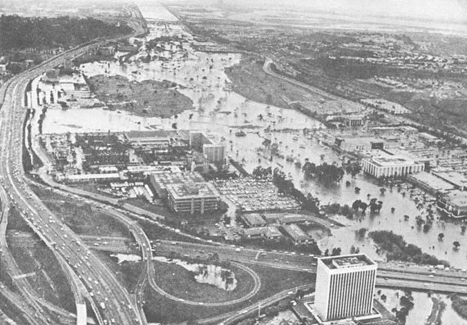
Figure 87
January 1979 oblique aerial view looking west down the San Diego River Valley during the peak of flooding that year.
Photo : Union-Tribune Publishing Co.
to 1821, the San Diego River usually entered San Diego Harbor. In the fall of 1821, however, a flood changed the river channel in one night, and the greater volume of the flow was diverted into what was then known as False Bay, leaving only a small stream still flowing into the harbor (J. C. Hayes 1874). This flood was remarkable in that no rain fell along the coast. The river was later observed
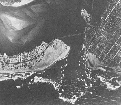
Figure 88a
Aerial photo of the entrance to Mission Bay, before jetties were built to maintain
the boat channel, 1944.
Photo : F. Shepard.
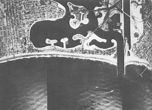
Figure 88b
Aerial photo of the same location as that in 88 a , following the construction of jetties at the mouth
of the San Diego River and the entrance to Mission Bay, 1968. The area north of the jetties was
extensively dredged to create a yacht basin and recreational facilities.
Photo : U. S. Army.
to flow into San Diego Harbor in 1849 and 1856, and the U. S. Coast and Geodetic Survey map of 1859 shows it to be flowing there once again. Because of the high deposition rate of the river, which threatened to ruin San Diego Bay as a harbor, the federal government diverted the flow into Mission Bay and built a levee embankment of earth extending from near Old Town to Point Loma in the fall of 1853 (Derby 1853). Later that year, heavy rains caused the river to change course once again, washing out part of the levee and resuming its old course into the harbor (San Diego Herald 1855). The worst flood in this area was in 1862, appropriately called the Noachian Deluge, and was of special significance because it had a bearing on the Civil War. In San Diego, Mission Valley was inundated, and houses in lower Old Town were flooded when severe winds from a sea storm from the south backed the water up from the bay into the river (Pourade 1964:250). This flood was very significant because it held its peak for over twenty-four hours. In 1876, the levee was reconstructed, and no further diversions into San Diego Bay have occurred. Since then, a considerable volume of sediment has been added to the San Diego River delta in Mission Bay from occasional floods.
In 1935 El Capitan Dam was constructed 27 miles up the San Diego River; this reduced the sediment entering the bay considerably. An earlier dam was overtopped in 1916, increasing the floodwaters coming down Mission Valley at the time. The Mission Bay and San Diego River jetties were built in 1948, at a time when the shore of the bay was subject to alternating periods of recession and advance. By February 1951, the river levees had been connected to the jetties. All tidal flow was confined to a new channel. Since the river discharges only during flooding, the middle channel was soon completely filled. The channels were finished by 1955, after various difficulties were overcome and the jetties were considerably lengthened so that shallow bars would not form in the entrance. Extensive dredging was done in Mission Bay to make the channel deep enough for a yacht basin, and other areas were developed to accommodate swimming and other recreational activities (figs. 88a , 88b ).
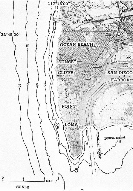
Figure 89
Location map of Ocean Beach, Sunset Cliffs, and Point Loma.