6—
Leucadia South through Solana Beach
Description of the Area
The communities of Leucadia, Encinitas, and Solana Beach to the south are located on beach and dune ridges of Pleistocene marine and nonmarine origin, about 80 to 120 feet above sea level (fig. 31). Cliffs on the seaward side consist of ancient lagoonal-barrier sand bars and open coast sediments. Rapid erosion has occurred in recent years as a result of extensive grading of the iron-oxide cemented dunes and soil horizon along the bluff top. In several areas, the dune has been entirely removed by grading. As a consequence, the natural drainage patterns were altered, and where water had previously flowed landward, away from the bluff edge, it was allowed to flow over and down the bluff face, causing erosion during even the early stages of construction. Once a dune has been removed, the underlying uncemented sand is eroded rapidly.
Old Surveys and Maps of Encinitas Showing Extensive Coastal Changes
The California Southern Railroad surveyed the coastal route from Colton south to San Diego many times between 1880 and 1891, and it was during this time that the county surveyor, L. L. Lockling, surveyed the first coastal town between the city of San Diego and San Juan Capistrano. This town was called Encinitas (Little Green Oaks). John Pitcher had purchased the land of 244 acres at one dollar per acre. The surveys, dating from 1880 to 1883, show more land than exists today: especially large changes took place before 1892.
Five very wet and stormy years followed the surveys, and the county tax assessor records show marked devaluation of seaward property, with a corresponding short-term increase in property value for lots directly inside the bluff edge. By 1889 the coast had changed dramatically as shown on a U. S. Coast Survey map and on composites of the maps from 1880 through 1891 (fig. 8b ).
Of particular interest is the effect of the highly localized storm of 12 October 1889, when 7.58 inches of rain fell at Encinitas in eight hours, while only .04 inch fell at Los Angeles and .44 inch at San Diego during the same period. A water storage reservoir up-canyon from the present-day Moonlight Beach on Cottonwood Creek collapsed, and a great wall of water roared down the canyon, washing away the railroad bridge and destroying ranches in its path (U. S. Signal Service 1889:279). Subsequent county assessor records indicate a devaluation of downstream property and a short-term increase of property directly inland.
As previously noted, in 1884, following the eruption of the Krakatoa Volcano in Indonesia, a short-term climate change occurred in southern California. The weather changed from semiarid and very dry to subtropical, and world-record rainfall levels were recorded. During February 1884, storms lashed the coast, causing flooding of all rivers, and all but two of the railroad
trestles between San Bernardino and San Diego were destroyed. For obvious reasons there was no building being done on the bluffs, beaches, or flood plains, or in the canyons during this period.
Construction on Bluff Tops and Methods for Preventing Bluff Erosion
Beginning in about 1973 condominiums and apartments have been constructed along the bluff tops, many within ten feet of the edge. Numerous recent geologic studies done by consultants for real estate developers indicate negligible erosion of these bluffs since 1928, based on early aerial photographs. What was not readily apparent to the investigators is that bluff and cliff erosion is episodic, site-specific, and directly related to climate changes. The impact of urbanization on the cliffs was also not taken into account.
Examination of sequences of photographs of a specific site revealed not only that erosion occurs sand-grain by sand-grain but also that it is largely episodic in nature, often involving failure of 100 feet along the cliff at one time. In 1973 it became apparent that in the middle of a drought period, cliff collapse was caused at least as much by groundwater and the effects of man as it was by wave erosion.
The groundwater table began rising in 1973, commensurate with urbanization of the adjacent areas. This rise resulted largely from an excessive watering of lawns and the introduction of non-native vegetation to the region. Other contributing factors include agricultural irrigation, leach lines, and cesspools. Sorbon and Sherrod (1977) indicate that overirrigation of landscaping in residential subdivisions alone is equivalent to fifty to sixty inches of rain per year on each lawn. This extensive overwatering in coastal areas has at least three important effects: it has caused a slow but steady rise in the water table, even during the driest period preceding the rainy year of 1978; it adds
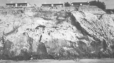
Figure 32a
Views of landslide along the bluffs in south Del Mar, 1977. Note that the groundwater
caused movement of the landslide directly seaward from the new construction during
this drought year.
Photo: G. Kuhn.
Figure 32b
February 1978 view of block fall and debris at H Street in Encinitas.
Photo: G. Kuhn.
weight to the cliff material and increases pore pressure; and this in turn contributes to landslides (fig. 32a ) and blockfalls (fig. 32b ).
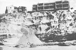
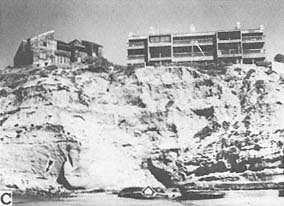
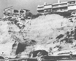
At one location condominiums were constructed over an unrecognized ancient river channel fill (figs. 33a , 33b ). Erosion at the base of the cliff, at the southern end of the condominium site, amounted to ten feet between 1971 and 1978 in two separate five-foot episodes. The homeowners in the project have gone to great expense to stabilize the cliff base and bluff face. In April 1978 a concrete crib wall, designed to prevent further erosion, was near completion (fig. 34a ). However, during the first week of May the crib wall collapsed, severely eroding the bluff face (fig. 34b ). A concrete seawall now exists at the cliff base, and the upper bluff face has been terraced with concrete (fig. 34c ) at a cost of over $2 million to the homeowners.
Figure 33a
Oblique aerial view of a portion of south Solana Beach prior to the
bluff-top development, 1954.
Photo: U. S. Navy.
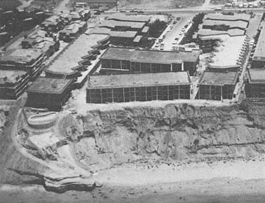
Figure 33b
View of the same site as that in 33 a following development of the bluff
top, 1974. Note that the bluff face began eroding during the construction.
Photo: B and A Engineering.
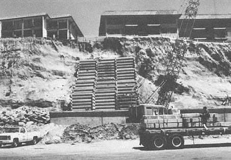
Figure 34a
April 1979 view of the concrete crib wall being installed on the bluff face at Solana Beach.
Photo: G. Kuhn.
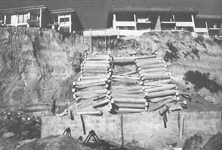
Figure 34b
May 1979 view of the same site as that in 34 a . Note that the crib wall collapsed
before completion.
Photo: G. Kuhn.
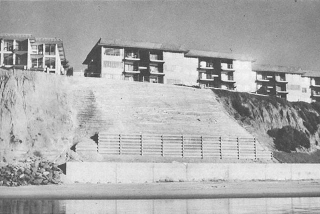
Figure 34c
View of the same site, 1980. The bluff face has been terraced with concrete, and the adjacent bluff face south of the terraces
has been planted.
Photo: G. Kuhn.
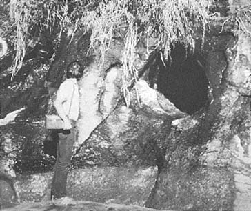
Figure 35a
View of a cave forming above sea level along a remnant of shear zone
in Leucadia, 1980. The cave was formed primarily as result of inland
groundwater exiting the cliff face.
Photo: G. Kuhn, January 1980.
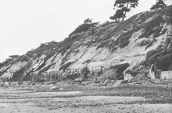
Figure 35b
View in the vicinity of 35a , showing the extensive cliff erosion that occurred during the storms of
January through February 1983.
Photo: G. Kuhn.
Formation and Collapse of Caves and Arches
A unique feature of this section of coast is its caves and seldom-formed arches. The caves are of three different types. First, in Leucadia, the caves are formed along weak rock shear zones four to eight feet above sea level and are solution-formed in origin rather than entirely caused by wave erosion (fig. 35a ). These caves enlarge laterally into the cliffs. They may grow downward and enlarge rapidly as they are abraded by beach cobbles and waves. Accelerated cave and cliff erosion occurred during the stormy period of January to March 1983 (fig. 35b ). Many cave roofs collapsed and cliff retreat amounted to ten feet in places.
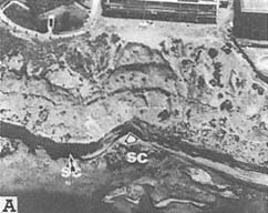
Figure 36a
Oblique vertical photo of condominium
construction in south Solana Beach, 1974.
Note the small cave at the base of the cliff.
Photo: B and A Engineering.
b . View of the same location as that in 36 a , 1975. The sea
cave was formed by beach cobble abrasion and marine
erosion along the vertical remnant shear zone and along
the essentially horizontal weak bedding plane. Note the
recent collapse of the upper unconsolidated sands.
Photo: G. Kuhn.
c . View of the same site as that in 36 a and 36b , 1977.
Note that the sea cave on the left has collapsed.
Photo: G. Kuhn.
d . June 1978 view at the same site as that of 36 a –c ,
following the storms of February through April
1978. The recently enlarged sea cave is the result of
beach cobble abrasion during high tides.
Photo: Sea Grant/G. Kuhn.
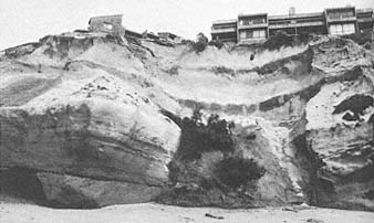
Figure 36e
April 1983 view at the same site as that at 36 a –d following the
latest collapse of the massive sea cave roof.
Photo: G. Kuhn.
Second, exposed caves in Encinitas and Solana Beach are mainly marine in origin and are seen to enlarge and collapse as a result of beach cobble abrasion with relatively small wave activity (figs. 36a –36d ). During the storms in January to February 1983, a massive sea cave roof collapsed, endangering the buildings on the bluff above (fig. 36e ). Third, a recent geological investigation in Solana Beach (Libby 1978; Shepardson 1978) indicates the presence of a large subsurface cavern inland of the cliffs (fig. 37). Concrete was poured into the void that had been encountered during construction. When it was not filled after forty-five minutes, it was assumed that the concrete was flowing into an intricate passageway. Normally such caverns occur in limestone or other soluble rock, not in sandstone. Solana Beach also has sea caves and tunnels caused by wave, sand, and cobble erosion.
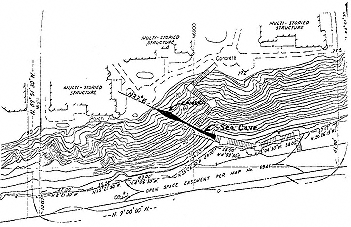
Figure 37
Map showing locations of the sea cave in the cliff face and the
cavern located directly inland. During construction, concrete was
poured into the cavern for forty-five minutes before it was realized
that an intricate passageway had been encountered. From Libby 1979.
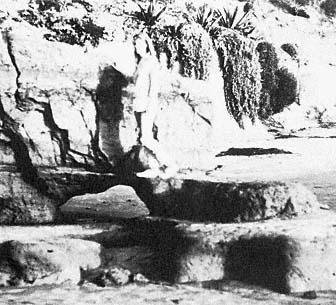
Figure 38a
December 1982 photo showing the early stages of a rapidly
enlarging sea arch forming in weakly consolidated rock.
Photo: G. Kuhn.
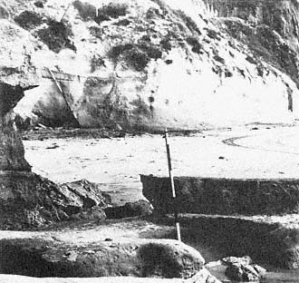
Figure 38b
January 1983 photo showing the same site after the arch
collapsed.
Photo: G. Kuhn.
During the storms in January 1983, many of these caves and tunnels were enlarged in as little as two days. Surprisingly, an arch was seen to form in the slightly consolidated Del Mar formation of Eocene age. It enlarged rapidly between 27 and 30 December, 1982, and collapsed on 1 January 1983 (figs. 38a , 38b ). As far as we know, this arch was formed by the hydraulic effect of moderate and excessively high tides, and without any cobble or sand abrasion. In late January and early February 1983, six feet of cliff face directly adjacent to the arch site also collapsed (fig. 39).
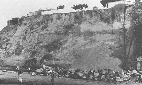
Figure 39
View of the cliff collapse at north Solana Beach, 1983.
Photo: G. Kuhn.
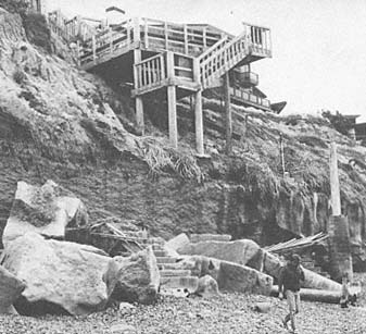
Figure 40
April 1983 view of the public stairway to the beach. The stairs,
in north Leucadia, were crushed by a mass that separated from
the cliff.
Photo: G. Kuhn.
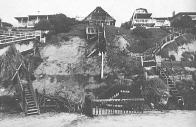
Figure 41
View of the private stairway that collapsed in Leucadia, 1978. Note that
the stairs failed as a result of a small storm-drain collapse.
Photo: G. Kuhn.
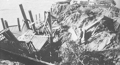
Figure 42
Photo of the stairway at D Street in Encinitas which collapsed as a result of surface
water flowing down the adjacent street end, undermining the underlying buried water
main and causing it to buckle, break, and erode the cliff, 1978.
Photo: G. Kuhn.
Loss of Beach Access Stairs
Public and private stairs of various types of engineering design were located along this section of coast. In March 1983 a section of cliff collapsed, crushing a public stairway and injuring several people who were on it at the time (fig. 40). This apparently was the result of a combination of wave erosion at the cliff base and groundwater sources inland. Along this same section of Leucadia, almost every homeowner, at one time, has had a private stairway to the beach. Most of these stairways have collapsed in recent years, often because of their proximity to broken storm drains and pipes (fig. 41), and many have fallen victim to storm waves. The severe winter storms of 1983 crushed many stairways and caused as much as ten feet of cliff retreat.
In Encinitas the cliffs are much steeper than elsewhere, and not many stairways, either public or private, have been built. One public stairway was constructed in 1977 at D Street at a cost of $100,000. This collapsed during the February 1978 storms (fig. 42), and it cost over $80,000 to remove the debris and replant the slope. This collapse, which resulted from surface runoff eroding an underground water main, should have been anticipated, since waterfalls had been observed at the site during winter storms in the 1940s. At the time of this writing, the county of San Diego has proposed to reconstruct the stairway at the same site.
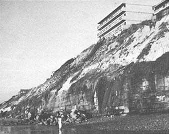
Figure 43
November 1977 photo of the apartment complex at F Street
in Encinitas. In the fall of a drought year 110 feet of cliff
collapsed as a result of subaerial erosion (groundwater
table rise) rather than marine erosion.
Photo: G. Kuhn.
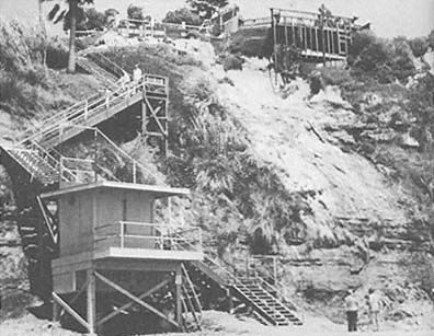
Figure 44
View of the public stairway at the Sea Cliff County Park in Encinitas, 1978.
A similar stairway collapsed and was crushed by a cliff failure at this
location in 1963. Note the recent cliff failure to the right of the stairs.
Photo: G. Kuhn.
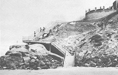
Figure 45
June 1977 view of the public concrete stairs at Solana Beach. The
stairway was located in the northern end of the embayment and was
thus semiprotected from direct wave action.
Photo: G. Kuhn.
Directly south a private stairway collapsed and was crushed by a 110-foot section of cliff in November 1977 (fig. 43). Stairways in Encinitas are subject not only to erosion by wave action and surface runoff but also to erosion by groundwater, as was the case when the stairway at Sea Cliff County Park collapsed in 1963. There was no public beach access at this location until the following year. The supports for the stairway now in use are being undermined and are separating again as the result of groundwater erosion (fig. 44).
At Cardiff State Park to the south, access stairways are partially protected at the base of the cliff by large blocks of stone, but the cliff itself is eroding around the stairway as water flows over the bluff and down the wooden stairway supports. Of the three public stairways in Solana Beach, two were thought to be particularly well designed in that the base of the stairs was located in protected cove areas away from direct wave action (fig. 45). During storms in late January 1983, however, the base of one stairway was completely destroyed by large waves (fig. 46).
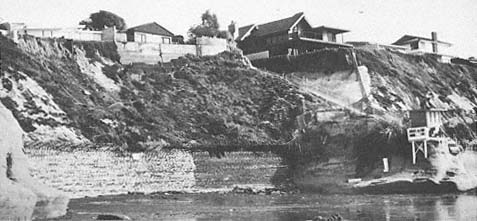
Figure 46
February 1983 view of San Diego County public beach access stairway at Tide Park in
Solana Beach. Note that the lower portion of the stairway was destroyed during
the storms of January 1983.
Photo: G. Kuhn.
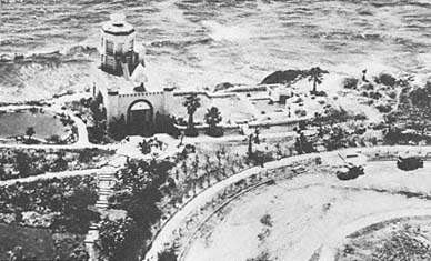
Figure 47a
Oblique aerial view of the Self-Realization Fellowship temple at Encinitas, 1938.
Photo: Self-Realization Fellowship.
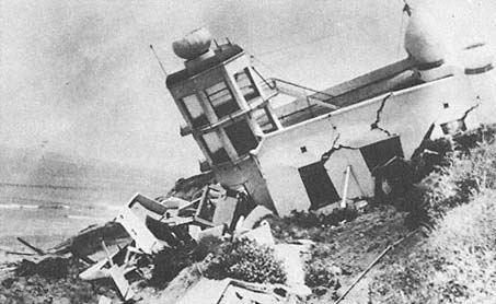
Figure 47b
View of the temple collapse in the early 1940s following significant sea storms
accompanied by intense sediment saturation of the bluff top.
Photo: Self-Realization Fellowship.
Erosion History at the Self-Realization Fellowship Property
In 1938 the Self-Realization Fellowship built a temple on the bluffs at Encinitas (fig. 47a ). Following storms in 1941 the temple, which had been constructed thirty feet back from the bluff edge, was a victim of frontal landslides and collapsed to the beach (fig. 47b ). This property is especially prone to erosion, and numerous landslides have occurred as a result of wave action as well as from a rise in the groundwater level. Piezometers, placed in wells on the site, clearly indicate a rise in the water table beginning in about 1973, commensurate with the inland urbanization (fig. 48). This rise began during the end of a drought period that lasted from 1946 to 1977.
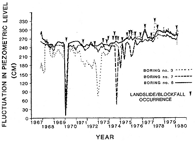
Figure 48
Piezometric well readings from three locations on the Self-Realization
Fellowship property in Encinitas. The small arrows indicate landslide
or block-fall occurrence. There has been a slow but steady rise in the
water table that began in 1973. This corresponds to extensive
urbanization and a marked increase in water use inland from this site.
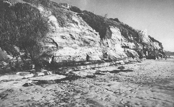
Figure 49a
February 1978 view of the cliff at the Self-Realization Fellowship. Note that the cliff face is not abnormally
undercut but that excessive wet conditions are visible.
Photo: G. Kuhn.
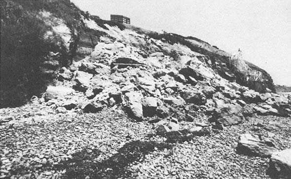
Figure 49b
May 1978 view of the same site as that in 49 a , following the cliff collapse of 26 April 1978.
Photo: G. Kuhn.
In April 1978, a cliff collapse measuring 110 feet along the bluff and 12 to 15 feet landward, with a maximum height of 40 feet, occurred at this same site (figs. 49a , 49b ). Saint and Turner (1980) investigated conditions at the site, including the 1978 event, and indicated that the cliffs in the area are subject to collapse because of a combination of factors. They state "large blocks, bounded by weakened joints, fractures, and bedding planes move out laterally following a build-up of pore pressure under the attack of wave action."
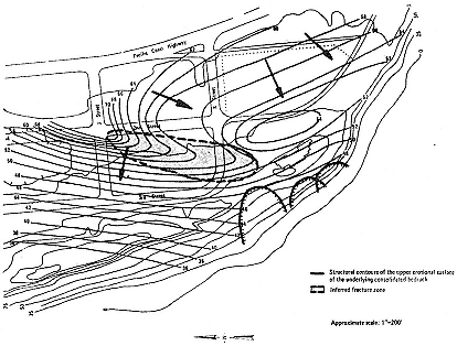
Figure 50
Subsurface groundwater movement along the old erosion surface. The arrows
indicate the approximate direction of the subsurface water.
From Saint and Turner, 1980.
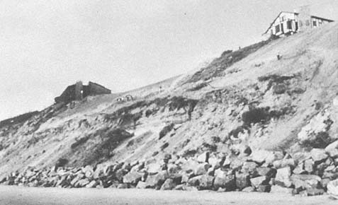
Figure 51a
View of the bluff face at the Self-Realization Fellowship, 1981. Note that the bluff face
was illegally graded and, as could have been predicted, it collapsed.
Photo: G. Kuhn.
After the storms in 1980, subterranean drains were installed around this property to intercept inland groundwater. Saint and Turner (1980) ascertained from a geological investigation that underground water was flowing directly under the Self-Realization property (fig. 50). An extensive stone seawall was installed along the cliff face in 1980. The bluff top was graded the following year, and, as could have been predicted, the cliff collapsed (fig. 51a ). Subsequently, it was covered with plastic sheeting to slow erosion of the bluff face (fig. 51b ). Since then the bluff face has been seeded and appears to be at least temporarily stabilized. Fortunately the winter of 1982 was very mild, with only a few storms and relatively little rainfall, so that not much erosion occurred. During the severe storms of January to March 1983, this was one of the few sites along the coast that was not damaged.
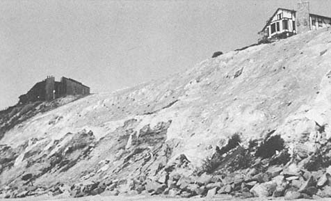
Figure 51b
May 1982 view at the same site as that in 51 a . Note that sheet plastic has been placed on
bluff face to slow erosion.
Photo : G. Kuhn.
Figure 52
March 1983 view of the bluff face at Cardiff-by-the-Sea. The highway collapsed at this location in the late 1950s.
The slope was stabilized, subsurface drain pipes were installed to intercept groundwater, and the slope toe was
semiprotected by installation of riprap. Note that riprap was scattered by the high surf in various places during the
storms of January through March 1983.
Collapse of Highway 101 and Subsequent Stabilization
In April 1958, a landslide occurred along the cliffs between Sea Cliff County Park and Cardiff State Beach. A section of Highway 101 collapsed, and one lane was lost for a distance of about 300 feet. The cliffs in this area, prior to the failure, were nearly vertical and were eroding as the result of groundwater from inland sources. In 1960, subsurface drains were installed parallel to the existing railroad track, inland from the cliffs, and pipes were run down the cliffs to remove the groundwater. The base of the slide was removed, the slope face cut back and stabilized, and rocks were placed along the base to slow future erosion. Many of the large rocks were scattered during the winter storms of January through March 1983, effectively cutting off lifeguard service even at low tide (fig. 52).
Figure 53
April 1983 view looking north along the beach at Cardiff. Note that the restaurants were severely damaged during the storms
of January through February 1983, when beach cobbles and riprap rubble became artillery and were thrown by large
waves into buildings and onto the coast highway.
Photo : G. Kuhn.
The Precarious Existence of Restaurant Row at Cardiff-by-the-Sea
During the past few years, numerous large restaurants have been constructed directly on the beach at Cardiff. This low-lying area has been inundated in the past when large storms breached or even temporarily removed the fragile sand barrier. During the last week in January and early February 1983, large storm swells, which coincided with the perigean spring tide, began to set the stage for extensive destruction along this area. Beach sand levels dropped markedly, and cobble rocks became projectiles, breaking out windows in the restaurants, undermining other places, and covering Highway 101 elsewhere to the south. The riprap rock that had been placed in front of one restaurant was ineffective in protecting the buildings and, in fact, many boulders weighing as much as 1,200 pounds were thrown through the air by the waves. This occurred where a large rampart of cobbles was formed in front of buildings; the large blocks of stone were first rolled seaward and then were catapulted through the structures. Some of these large rocks even came to rest in the middle of Highway 101 more than 80 feet inland. Since March 1983, larger riprap has been placed in front of the buildings and cemented (fig. 53). A great storm would probably break this barrier up leaving the restaurants in a definitely hazardous position.
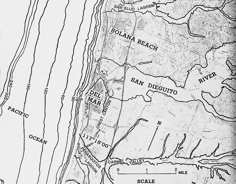
Figure 54
Location map of Del Mar and vicinity. Note: Bathymetry in feet