Chapter 2
People and Territory in Cotabato
Aden maulad a lupa
a gadung a pedsandengan
Behold in the distance
a wide green land.
The Land
The wide green land evoked in the first line of a popular song of the Muslim separatist rebellion is a metaphorical reference to the territory known as Cotabato and a description of the Cotabato River Basin, the broadest expanse of lowland on the island of Mindanao and the most densely settled. Mindanao is the second largest island in the Philippines, and "Cotabato" (see map 1) is the term used to refer to the entire southwestern quadrant of Mindanao, which is divided into roughly half lowland and half upland areas. That region formed the domain of the two principal sultanates of Mindanao. With colonialism it was incorporated as a single political subunit—the District of Cotabato—under the Spanish and Americans, and the Province of Cotabato under the Philippine republic. It is presently divided into four separate provinces but still considered collectively as Cotabato. The hydraulic, demographic, and political hub of Cotabato has always been the Cotabato River Basin.
The Cotabato Basin is drained by the Pulangi River, referred to respectfully by the Spaniards as the Rio Grande de Mindanao. The Pulangi has its source in the Central Mindanao Highlands near the northern coast of the island and flows southward across the Bukidnon Plateau. It then emerges onto the Cotabato plains, depositing fertile mountain silt as it widens and arcs westward through the 1,000-square-mile Cotabato River Basin, and finally empties into Ilana Bay.
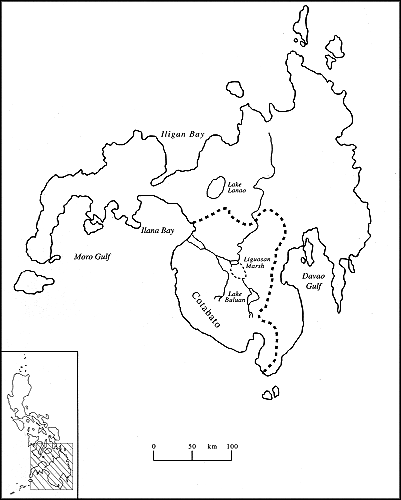
Map 1.
Cotabato and the Pulangi River system
Where the river makes its wide turn to the west, two large marshlands—the Libungan and Liguasan Marshes—have been created. Together they cover an area of 450 square miles during normal water levels, with each marsh expanding dramatically when the river overflows its banks during seasonal rains. This periodic inundation of much of the valley floor is the source of the name for the principal ethnolinguistic group of the Cotabato Basin—the Magindanaon. The word "danao" refers to inundation by water, and "magindanao" is likely a shortened form of "mag inged sa danao" or "those residing at a flooded place" (Llamzon 1978, 131). The Magindanaon, or "people of the flood plain" (Stewart 1977) lent their name, in its shortened form, to the entire 36,000-square-mile island, called Mindanao by the Spaniards in apparent acknowledgment of the extensive territorial influence of the Magindanao Sultanate, the foremost principality of the island.
The term "Cotabato" is a hispanicized version of the Magindanaon "Kuta Watu," or fort of stone. That Spanish appellation for the city and region (formerly identified on maps as Magindanao or Mindanao) was said by Najeeb Saleeby, writing early in the twentieth century, to be "very modern" (Saleeby 1905, 13). The name "Cotabato" was taken from an actual stone fort that stood on Tantawan Hill in the middle of present-day Cotabato City (Mastura 1979; Millan 1952). About twenty miles before reaching the sea the Pulangi splits into two branches. The narrower southern fork is known as the Tamontaka River. The wider north fork of the Pulangi flows past Cotabato City, which is located on its southern bank about four miles above the river mouth. The Pulangi also collects water from several large tributaries along its lower course.
The Cotabato Basin (see map 2) is bounded on the southwest by the Tiruray Highlands. These uplands extend for more than 125 miles along the Moro Gulf and Celebes Sea and descend sharply to the west, dividing a slender coastal plain from the long and narrow Alah Valley. To the north lie the Bukidnon-Lanao Highlands, which encompass nearly all the northern portion of the island. The Lanao Plateau and Lake Lanao Basin lie at the southwestern corner of these highlands, closest to the Cotabato Valley. The densely populated basin of Lake Lanao is the single exception to the general pattern of sparse settlement in the highlands. To the east lie the Central Mindanao Highlands, a succession of mountain ranges that separate the Cotabato Basin from the lowlands facing the Davao Gulf.
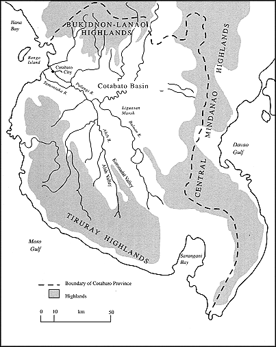
Map 2.
Physiography of southwestern Mindanao
The People
The indigenous inhabitants of the Cotabato Basin are divided into three principal language groups. While Magindanaon speakers far outnumber speakers of the other two languages and figure most prominently in the present study, knowledge of all three groups is essential for comprehending past and present political relations.
The Magindanaon
The largest indigenous ethnolinguistic group in the Cotabato River Basin are the Magindanaon.[1] For most of the recorded past they have also been the politically dominant population. The 1980 Philippine census estimated their number at 644,548 persons, or 25.7 percent of the total Philippine Muslim population. This figure places them as the second largest of the thirteen Philippine Muslim ethnolinguistic groups (IBON Databank 1981; Abbahil 1984).[2] Two major dialects of the Magindanaon language are spoken in the Cotabato Basin.[3] The terms for these two dialects—tau sa Laya (upriver people) and tau sa Ilud (downriver people)—are place-names indexing the fluvial orientation of a people living along a great river. This dialectal separation reflects demographic, cultural, and political polarization between the two major historical population centers on the Pulangi, one at its mouth in what is now Cotabato City and the other thirty-five miles upstream near the present-day Datu Piang. These two settlements were, respectively, the traditional seats of the Magindanao Sultanate and the Buayan Sultanate—interdependent but dueling realms for most of their histories.[4]
The distinction between downstream (ilud) people and upstream (laya) people has as much subjective as objective import. Downriver people tend to view themselves as the "true" Magindanaon, citing their "purer" dialect, their (somewhat) earlier exposure to Islam, and their connections to the Magindanao Sultanate, the first and hence noblest Magindanaon royal house. They hold this view in spite of (perhaps because of) the fact that the Magindanaon of the interior have dominated indigenous cultural and political life in the valley for the past 150 years. Many continue to distinguish tau sa laya (upriver people) from "Magindanaons" in the same manner as my downriver neighbor in Cotabato City, who remarked of tau sa laya immigrants to the city: "How can they call themselves 'Magindanaon' when they cannot even speak our language?"
Despite some dialectal and cultural differences, the upriver and downriver Magindanaon in the historical period have shared social and political institutions, a profession of Islam, certain symbols of collective identity in dress and ornamentation, and similar means of subsistence. Traditional Magindanaon communities tended to be dispersed along the banks of the numerous waterways of the Cotabato Basin. Thomas Forrest, writing in 1775, describes the pattern:
In a country thinly inhabited, and where ground is of no value, Mahometans especially choose not to crowd together; each desiring a house on the bank of a river. Peculiarly is this visible here, where upon the winding [river] banks . . . and the sides of the many creeks that intersect the ground between . . . rivers, at the distance of almost every three hundred yards, sometimes we see a single house, sometimes a group of houses, with gardens of coconut, mango, and plantain trees, sugar canes, and rice fields, for many miles up those rivers . . . Wherever is a house, there is a small portion of the river sufficient for bathing, railed in, against alligators. (Forrest 1969)
For the Magindanaon, the Pulangi River system, with its tributaries, channels, and estuaries, has been a source of food and water, a principal thoroughfare, and the means of trade and communication with the outside world. Control of the Pulangi has thus been crucial for the acquisition and maintenance of political power by the rulers of the Cotabato Valley throughout the historical period. The traditional Magindanaon were horticulturists, growing either dry rice in upland fields or wet rice in lowland paddies. In the modern period many Magindanaon have shifted to plow and harrow methods of wet rice cultivation (Stewart 1977).[5]
The Iranun
Writing in the mid-nineteenth century, the Spanish chronicler Francisco Gainza described a population of skilled and fiercely independent sea raiders living along the eastern shore of Ilana Bay who called themselves "Iranun."
[T]his large population, designated by some geographers with the name of the Illana [Iranun] Confederation, in reality does not form a single political body except to defend its independence when it is found threatened . . . They live loaded with weapons; they reside in dwellings artfully encircled by barricades . . . and they maintain their bellicose spirit by continuously engaging in robbery and theft. Through piracy they strive to gather slaves for aggrandizement and to provide their subsistence . . .
In short, this particular society can only be considered a great lair of robbers, or a nursery for destructive and ferocious men. (Quoted in Bernaldez 1857, 46–47)
The Iranun today are a population whose size has never been accurately estimated by a government agency but who probably number somewhere between 50,000 and 150,000 individuals.[6] Most Iranun continue to reside along the eastern shore of Ilana Bay, although some have also long inhabited the hill country lying between the coast and the southern edge of the Lanao Plateau. The Iranun language is closely related to the languages spoken by the Iranun's more populous Muslim neighbors, the Magindanaon and the Maranao of the Lanao Plateau.[7] The Iranun share with their neighbors the profession of Islam, as well as a number of other cultural institutions. There has long been intermarriage between the Iranun, Magindanaon, and Maranao, and the percentage of intergroup marriages has increased since midcentury.
As Gainza's account indicates, the Iranun living at the coast once practiced a distinctive maritime adaptation. For at least 150 years prior to the inception of American colonial rule at the turn of the century, they specialized as seagoing marauders. The Iranun raided throughout island Southeast Asia, from the Celebes in the south to Luzon in the north and as far west as the Straits of Malacca, attacking merchant shipping and coastal settlements in search of slaves and plunder.[8] They continue their seafaring ways today, but now as fishermen and long-distance traders.[9]
The Tiruray
The Tiruray are non-Muslim[10] upland horticulturalists who inhabit the northern portion of the Tiruray Highlands. In 1980, the Tiruray were estimated to number about 30,000 persons (Schlegel 1977). The Tiruray have made their living as shifting cultivators in the densely forested mountains and valleys of the highlands, growing rice, corn, tobacco, and other crops in upland fields and foraging in the surrounding forests.
For centuries the Tiruray have maintained significant trade relationships with Magindanaon communities in the lowlands. Similar to the pattern found throughout Southeast Asia, this upland-lowland trade involved exchanges of forest and swidden products for iron tools, cloth, and salt, and took place within unequal and often coercive clientage arrangements. Since the beginning of the American occupation at
the turn of the century, the Tiruray have been experiencing rapid social change. Today they are divided approximately in half between those more accessible communities that have been drawn into plow agriculture and all its attendant sociocultural transformations, and those communities of still-traditional people in the remote forests of the Tiruray Highlands (Schlegel 1979). As a result of the extensive and detailed ethnographic fieldwork of Stuart Schlegel, more is known about traditional Tiruray subsistence and social life than about any of the other indigenous populations of Cotabato (see, e.g., Schlegel 1970, 1972, 1979).
Contemporary Cotabato: The Region and City
The daily Philippine Airlines flight from Manila to Cotabato City wings south over the Sulu Sea to Mindanao, then veers east across the Zamboanga Peninsula and Moro Gulf to approach the Cotabato coast from the west. As the coast and airport come into view the initial peaks of the Tiruray Highlands are visible on the right to the south of the city. This is the territory of the Tiruray, now increasingly denuded by loggers and occupied by Christian settlers. To the left, north of the city across the Pulangi River, are the last reaches of the Bukidnon-Lanao plateau, and the principal mountain stronghold of Cotabato's Muslim separatist insurgents. On the coast below, near the mouth of the river, stands the lone mesa known as Timako Hill, and offshore, the dark crescent of Bongo Island. Looking east and inland, the Cotabato Basin widens and reaches to the horizon. The broad Pulangi River may be seen above its fork at Kabuntalan, stretching as far east as Datu Piang, the old capital of the upriver sultanate.
Directly ahead, Cotabato City extends for about three miles along the southern bank of the north fork of the Pulangi River. As is typical of cities in the southern Philippines, the officially designated perimeter of Cotabato City encloses an area much larger than the city proper. The political boundaries of Cotabato City encompass all of the territory that lies between the forks of the Pulangi, from their common origin at Kabuntalan to liana Bay, an area of about 176 square kilometers. Large areas of land above and below the urban area are semi-flooded and roadless. The city proper is also encircled by water, almost all of it lying within the area circumscribed by the Pulangi, Manday, Matampay, and Esteros Rivers. For most of its history as the downriver capital, water transport was the most reliable means of travel in
and around the city, and the Pulangi River was its main thoroughfare. Today, the Pulangi continues to carry significant traffic, comprised primarily of the Muslim inhabitants of the city. A traveler's account from the early 1960s (a period of relative prosperity for many Muslims in the city) captures the contemporary atmosphere of urban life along the Pulangi: "At Cotobato [sic ] it is life on the water for everyone. There are hundreds of motor-boats, steam vessels, launches, outrigger canoes (some without outboards) and large, ponderous, box-like barges with brightly clothed people sitting on or clinging to every available perch . . . There is a feeling of eighteenth-century Venice, of Canaletto and Guardi, in the intimacies of daily life observed along this waterway . . ." (Kirkup 1967).
A cutoff channel, dug in the early 1960s, begins at the western edge of the city and slices an unnaturally straight route to the sea, facilitating access from Ilana Bay and lessening the occurrence of serious floods in the city caused by the Pulangi overrunning its banks. Cotabato City now relies on roads and bridges for most of its transportation, and a major road bisects the city, running perpendicular to the Pulangi.
Cotabato City remains today the principal commercial center for Cotabato, although the original province has been divided into four separate provinces.[11] That division is directly related to the most significant political and economic development of the modern era—the mass migration of Christian homesteaders from the northern and central Philippines to Cotabato. Magindanao Province (see map 3), which encompasses somewhat more than half of the Cotabato Basin (that closest to the Pulangi River) as well as the northern portion of the Tiruray Highlands, is the only one of the four provinces in which indigenous inhabitants comprise the majority population. [12]
The Cotabato Basin's long-recognized promise as the future "rice granary" of the Philippines appears to be approaching fulfillment. Rice production in the basin has increased steadily since I982,[13] although yields per hectare continue to vary significantly from area to area.[14] Corn and coconuts (the latter yielding the export commodities copra and coconut oil) are the other two principal agricultural products of the basin.
As the primary agricultural service center for the Cotabato Basin, Cotabato City is the site of large hardware, machinery, and chemical supply stores; the head offices of rural banks; rice and corn mills; and copra and rice dealers. As the principal city of southwestern
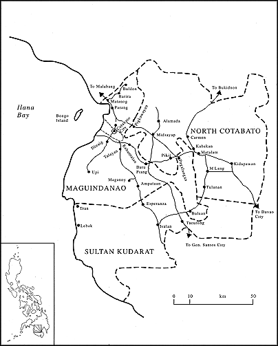
Map 3.
Three present-day provinces of the Cotabato Basin
Mindanao, Cotabato is also a center for transportation, communications, postsecondary education, and government services.[15] There are no large industrial enterprises in the city, although six fairly large agro-processing firms are located in the near vicinity.[16] For most of its colonial and postcolonial history, Cotabato Town was the poblacion , or capital of the Province of Cotabato. In 1959, the capital town of Cotabato was converted into a chartered city and granted administrative and fiscal autonomy from the province.
Cotabato City has an estimated 1990 population of 127,000 persons, of whom about 48 percent are Muslims (NEDA 1992). It exhibits many of the characteristics of a secondary city of substantial size. The city contains bars, nightclubs, restaurants, and movie theaters. It boasts private schools and colleges, civic groups, radio and television stations, and two weekly newspapers. It accommodates beggars, fugitives, prostitutes, and transvestites; and it is the scene of violent crimes, security guards, and profound disparities in wealth and status. At the same time, Cotabato City retains some features associated with much smaller communities. Important information is communicated broadly and with remarkable swiftness by word of mouth; and the city elite, comprising both Christians and Muslims, tends to be quite well-integrated.
One of the most noted features of Cotabato City is its ethnic diversity.[17] In addition to indigenous Magindanaon and Iranun inhabitants, who comprise about 46 percent of the population, the city is composed of immigrants from other regions of the Philippines, the vast majority of them Christians.[18] Cebuanos and Illongos from the central Philippines together make up about 25 percent of the city's population, and Tagalogs and Ilocanos from Luzon in the northern Philippines comprise another 22 percent. About z percent of the city's population are immigrant Muslims, mostly Maranao from Lake Lanao just to the north. Most of the Chinese residents of the city are also non-Christians. Though they are also immigrants to the region, ethnic Chinese have resided in Cotabato for at least four hundred years, centuries longer than any other immigrant group. In sharp contrast to virtually every other city in Mindanao, in Cotabato City Tagalog (the national language of the Philippines) is the lingua franca.[19] This is likely a result of the ethnic diversity of immigrants but also the fact that many of the earliest Christian immigrants to the city were Tagalog speakers who came as civil servants under Spanish and American colonial administrations. A fairly distinct ethnic division of labor has obtained in the
city for some time, altered only somewhat in the past twenty years. The ethnic Chinese tend to control both retail trade and the processing of agricultural commodities. As evidenced elsewhere in the Philippines and throughout Southeast Asia, the significance of their economic role is far out of proportion to their numbers. Tagalogs have tended to be heavily represented in government service as administrators, clerks, and teachers. Visayan migrants (Cebuano and Ilonggo speakers) are generally found in the professions, in agriculture, and in commercial establishments such as barbershops and drugstores. The Magindanaon and Iranun comprise a large percentage of the fish-sellers, street vendors, and stevedores in the city. Other Muslims are farmers, fishermen, or goldsmiths, and some own and operate inter-island vessels or small rice mills.
By far the most subjectively significant ethnic division in Cotabato City is that between Christians and Muslims—between indigenous Muslim inhabitants and Christian immigrants. The topic of Muslim—Christian relations in Cotabato has been addressed in a number of written works (see, e.g., Hunt 1957; Schlegel 1978; Gowing 1979; Rodil 1986), and Muslim-Christian conflict remains the most typical framework for discussing ethnic politics in Cotabato and all of the Philippine South.[20] I have chosen to approach the politics of group identity in Cotabato from a somewhat different direction—focusing principally on the internal dynamics of Muslim politics in the region. Nevertheless, Muslim politics are inexplicable without some knowledge of the nature of Muslim-Christian relations in Cotabato City.
Cotabato City Christians are possessed of an ethnoreligious chauvinism that stems from their identification with a dominant national culture—that of Christian Filipinos (who comprise more than 90 percent of the population of the Philippines). Voiced attitudes of local Christians toward indigenous Muslims tend to oscillate between paternalism and apprehension, either expressing condescending tolerance for a benighted folk or betraying anxiety about "uncivilized" (and thus unpredictable) neighbors. Ordinary Christians appear to be accepting of, and comfortable with, particular Muslims in direct proportion to the extent to which those Muslims exhibit the cultural markers of Christian Filipinos. Such markers include speaking Tagalog or English, wearing completely Westernized dress, and, in the case of men, drinking alcohol. Although a few Christians vaunt their ability to speak "Muslim" (Magindanaon), the great majority, even those who have lived in Cotabato all their lives, neither speak any indigenous language
nor possess any appreciable knowledge of Muslim customs. This does not seem to be the result of a lack of regular ethnic interaction. Although the local economy is structured in such a way that Christians do not ordinarily employ Muslims, Christians do regularly engage in commercial transactions with Muslims, attend school with them, and, today, work side by side with Muslims in government offices. That local Christians who have studied and worked with Muslims nevertheless express unfamiliarity with their most basic cultural beliefs and practices indicates that Christian ignorance of Muslim customs results from lack of effort rather than insufficient contact.
One illustration of the publicly expressed attitudes of Christians toward Muslims is found in the remarkably persistent pattern of editorial comment in the local newspaper disapproving of Muslim street vendors. During a three-year period from 1985 through 1988—the years covering my first two visits to Cotabato—the Cotabato City newspaper ran regular front-page editorials accompanied by photographs (often on a monthly basis), complaining that Muslim street vendors were a hygienic hazard because they sold fruits or vegetables on the ground and a public nuisance because they blocked walkways. Street vending is engaged in by both Christians and Muslims but is a particularly significant source of income for poor Muslims, many of them women, who sell fruit, vegetables, tobacco, or cigarettes in various parts of the city. Given that pedestrian paths in the city are frequently blocked by a wide variety of commercial and noncommercial activities, and that poor sewage disposal and sanitation have been intractable problems in the Christian-dominated public market, the underlying complaint in these editorials appears to be not that Muslim street vendors are especially unsanitary or obtrusive, but that they appear prominently out of order in Christians' comprehension of the city in which they predominate.
As citizens, albeit mostly reluctant ones, of a predominantly Christian city and state, the Muslims of Cotabato City are generally much more conversant with the cultural beliefs and practices of Christian Filipinos than Christians are with local Muslim culture. Virtually all Muslims under the age of forty speak Tagalog, and a number of younger Muslims, as well as some older men who attended school during the American period, speak English. Local Muslims are regularly exposed to the dominant national culture through popular films, radio, and comic books. Their most protracted exposure to the national culture, however, comes during their education at state-sponsored
1.
Muslim street vendor selling tobacco in Cotabato City.The great
majority of Muslim street vendors are women, many of them older
women, who support their families selling fruits and vegetables,
betel, tobacco,and other items on the street corners of the city.
schools.[21] The great majority of Muslim children in the city attend state schools for a minimum of six years, most continue for an additional four years, and a fair number carry on for a further four years of postsecondary education. Most young Muslims have Christian school acquaintances, and a few have Christian friends. Muslim-Christian marriages, most commonly between Muslim men and Christian women, are not at all uncommon in the city. Many younger Muslims also tend to join, at least indirectly, in the celebration of Christian holidays such as Christmas, New Year's Eve, and Saint Valentine's Day.
Cotabato City possesses a reputation, justified by the available evidence, for maintaining harmonious Muslim-Christian relations. Residents point out that, even during periods of violent conflict between Muslims and Christians in the region, armed sectarian clashes were virtually absent in the city. For most of the past thirty years Christians have supported Muslim politicians for city offices and Muslims have voted for Christian candidates. At the same time, Muslims are aware that Christians have been better able to advance their own interests in the city because of their greatly superior economic and political power. Finally, we sharpen our focus to examine a particular urban Muslim community—Campo Muslim.
The Community of Campo Muslim
As a poor Muslim community constructed on the fringes of a city now dominated by Christians, Campo Muslim stands as an architectural testament to the peripheralization of Cotabato's Muslims under the Philippine republic. Campo Muslim is a shantytown assembled in a riverside marsh. In 1985 it consisted of 520 houses with more than forty-two hundred residents. Campo Muslim faces the Pulangi River and is bordered by two older and more prosperous communities. Just upriver and closer to the center of the city is the community of Manday. Manday has a majority Christian population, paved roads, and a large Catholic church. Adjoining Campo Muslim on the west is Lugay-lugay. The residents of Lugay-lugay are primarily Muslim and middle class. Formerly, they consisted mostly of successful smugglers or Muslim Chinese-mestizo merchants.[22] Today it is also composed of supervisory-level civil servants employed by the regional government. Lugay-lugay features paved roads, a large public elementary school, and an impressive mosque.
As its name suggests, Campo Muslim is a self-consciously Muslim community with 99 percent of residents identifying themselves as Muslims. The community contains two simply constructed mosques and two Islamic schools. Although its residents are not uniformly poor (a few households would be considered relatively wealthy by Cotabato City standards), Campo Muslim is the poorest community of its size in the city. There are no paved roads and no sewage or drainage systems of any kind. More than 70 percent of households are without toilets and three-quarters lack running water. Less than half of the households in the community have electricity hookups.[23]
The average Campo Muslim dwelling covers ninety square feet of ground (roughly the size of a child's bedroom in a typical American house) and houses eight persons. Nearly 20 percent of the houses in the community are less than sixty square feet in size. Most of these are extremely rudimentary shelters with partially open sides. Because of the community's location on the outskirts of the city, natural building materials tend to be inexpensive or, as with coconut fronds, freely available. As a consequence, relatively few houses in Campo Muslim resemble the barong-barong shanties found in Manila and other large cities, dwellings constructed of cardboard, paper, plastic sheeting, and other discarded industrial materials. Most Campo Muslim dwellings are assembled from some combination of wood (either used or flawed pieces bought cheaply at a nearby lumberyard), nipa palm, and split bamboo. About half of the houses have corrugated metal roofs. The simplest dwellings are constructed of nipa and coconut fronds. In sharp contrast to the two neighboring communities, relatively few houses (15 percent) incorporate any concrete in their construction. Most of the approximately sixteen-hectare area of Campo Muslim is owned by two individuals; the largest portion by a Chinese-mestizo Muslim who lives in Campo Muslim, and a smaller section by a Christian businessman who lives in neighboring Manday. Campo Muslim residents are not squatters. They pay monthly land rents to one of the two owners.
As a community composed largely of urban migrants, Campo Muslim exhibits considerable diversity in dialect and place of origin. In 1985, when I conducted my community census, about 30 percent of household heads hailed from upriver (sa laya) municipalities. Another 58 percent had birthplaces in downriver (sa ilud) municipalities. The remaining 12 percent included those with birthplaces in localities south of Cotabato City along the coast (taga-biwangan ) and to the north
across Ilana Bay (taga-kawanan ). Magindanaons constituted the largest ethnic category in Campo Muslim, with 58.8 percent of household heads identifying themselves as Magindanaon. Those who identified themselves as Iranun comprised the next largest category, at 34 percent. Maranaos made up only 3.5 percent of community residents. Thus, three separate languages are spoken in Campo Muslim, as well as at least four distinct dialects of Magindanaon.
The urban diversity and poverty encountered every day by Campo Muslim residents cannot be satisfactorily conveyed in quantitative terms. Enumerations alone fail to evoke the texture of daily life in a crowded community of mostly impoverished migrants. The most severe poverty in Campo Muslim is hidden away from casual observers or passersby. The community is segmented by three or four dirt roads (built using soil brought from outside) bordered by houses. The interior portions of the community, those that lie behind the roadside houses, remain at least partially flooded throughout the year. Here in the interior (sa lusud ) live most of the poorest community members in simple shelters crowded closely together. The following passage from my field notes describes a typical dwelling sa lusud:
Babu Ensay's house is two-storied and covers about 70 square feet of ground. The walls are of ragged nipa [woven palm] panels, cardboard, and paper. The house stands on very low ground and the first floor often floods. The floor is constructed of coconut fronds laid across a wooden frame. A tiny hearth sits just inside the entranceway. Other than one or two cooking pots there are very few belongings and no furniture of any kind on the ground floor.
A crude ladder leads to the second floor, which has a nipa roof and a floor of split bamboo. Upstairs are a few mats and some cardboard boxes for storing clothes and other items. At the time I was there, Babu's husband, Bapa Akub, who works as a laborer at the pier, was repairing damage to the roof from the previous night's storm. Virtually all their belongings had been soaked by the rain.[24]
Sa lusud residents enter and exit by way of narrow passageways, over ever-wet stepping stones and precariously balanced planks. It is here, inside, that one finds the highest incidence of infant mortality, malnutrition, and tuberculosis. Life is only somewhat less difficult for most of the residents sa liyu (of the exterior) bordering the roads. For the great majority of community members, Campo Muslim is a demanding and often disheartening place. Closely built houses and narrow paths offer no privacy, and the lack of toilets for most makes defecation an uncomfortably public act at the nearby Pulangi River.[25] The rapid rate
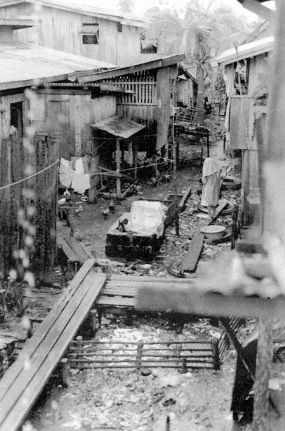
2.
A view of the interior (sa lusud) of Campo Muslim after a heavy rain.
of movement into and out of the community means that neighbors are often neither relatives nor friends and sometimes are scarcely acquainted. The threat of fire hangs over the crowded community and residents suffer repeated infections because of poor living conditions. No regular police force provides protection in the community, and burglars regularly steal clothes and cooking pots from families who own little else of value.
Residents often experience their deprivation as a sense of marginality. Christian city dwellers very rarely enter Campo Muslim. Most have never been near it. In the eyes of city Christians, Campo Muslim is a far-off place lying outside the Christian pale and harboring Muslim bandits.[26] Many Campo Muslim residents have accepted this characterization and self-consciously view their community as remote and separate from the city, even though they can walk to the city plaza in less than fifteen minutes, and despite the fact that community members play an integral part in the city economy as laborers, fish and vegetable vendors, and drivers of the motorized pedicabs that serve as the main form of public transportation in the city.
Just the same, Campo Muslim is a vibrant locality, one suffused at times with an almost buoyant energy. Each morning the main road fills with traffic as residents make their way to work or school. Every evening the same road becomes a meeting place where adults gather to share news and teenagers joke and sing, while children absorbed in exuberant street games swirl among them. A variety of musics played on scores of radios and tape players continuously enlivens the surroundings, and colorful flowers in coconut shell planters brighten the poorest dwelling sa lusud. And community residents, despite their differences and deprivations, share a strong sense of being members of a Muslim community—the largest in the city. That sense of solidarity is most evident during ritual suspensions of normal social life, in particular the puasa , or annual fast of Ramadan. But it is also apparent, in less dramatic form, in many small but significant aspects of ordinary activity in the community.
As noted, most community members are acutely conscious of being poor Muslims in a city dominated by Christians. That awareness has induced a tempered resentment toward city Christians that may occasionally be agitated into intense anger by a perceived offense.
I witnessed one such infuriation in Campo Muslim on the morning of the most important Muslim holiday of the year in Cotabato, Buka, or Eid al-Fitr, the celebration that marks the end of the month of
fasting. It is customary to bathe on the morning of Buka before dressing in one's best new clothes to attend congregational prayers at the local mosque. As households awoke just before dawn that day, and members prepared to bathe, they found that the taps that supplied them with city water were dry. The unannounced shutoff of city-supplied water was not a rare event, but neither was it a regular occurrence. This shutoff was especially inopportune for community residents, as they were forced to use the available stored rainwater or bathe in the dirty Pulangi River. Young men voiced their outrage throughout the early morning, declaring that the lack of city water was a work of "sabotage" by kafirs (disbelievers—referring, in this case, to the Christians who control the city). But community frustration gradually evaporated as bathing was accomplished despite the lack of city water and residents commenced a long-awaited day of festivities. Community anger at the shutoff of water was not simply aimed at city Christians as infidels, but as immigrants, who today dominate a city and region once ruled by indigenous Muslims.
The anger of Campo Muslim residents on this occasion was unmistakably an ethnic anger, one directed at any and all non-Muslim out-landers. At other times, however, community or individual ire sparked by living conditions in Campo Muslim has been aimed at other, more specific targets—Ferdinand Marcos, the city mayor, the Muslim barrio captain, even at Islamic clerics.
We turn now to consider the history of power relations both within Cotabato and between Muslim rulers and various outsiders. The three chapters that follow survey power relations in Cotabato in the precolonial and colonial periods. The external aggression and colonial subjugation experienced by the Muslim polities of the South constitute the root causes for the marginalization of Cotabato Muslims in their traditional homeland and for the Muslim separatist movement. In addition, investigating the history of political and economic relations among Muslim overlords, their subordinates, and various agents of external powers provides the essential foundation for evaluating both the mythic representations of Muslim nationalist ideologues and the responses of rank-and-file followers to them.