Voyage to Paradise
en passando de allí al Poniente, ya van los navíos alçándose hazia el cielo suavamente, y entonces se goza de más suave temperancia.
for in passing to the West, the ships go rising gently toward the heavens, and then a milder climate is enjoyed.
Columbus, "Relación del tercer viaje"
The fact that the historical event commonly referred to as the Discovery of America was necessarily conceived and carried out in the form of a voyage has been studied extensively by scholars of maritime history and sailing enthusiasts alike. Among the aspects of the Columbian enterprise that continue to figure prominently in the discussions stimulated by the Quincentenary are Columbus's biography, his navigational abilities, the nature of the fleets and crews, the reconstruction of the actual route, and the identification of the precise landfall. It has been standard practice to plumb the Columbian accounts for evidence to recreate the historical circumstances of the navigation. Yet there has been surprisingly little interest in the character of the texts themselves as accounts of travel.[1]
Though it seems too obvious to state, many of the Columbian texts are travel literature. Individually and collectively, the accounts of the voyages tell the Discovery as the story of a journey; that is, they articulate the historical event of the navigation within the rhetorical bounds of the literature of travel available in Columbus's culture.
To consider the Discovery as a story in no way detracts from its gravity as a historical event.[2] Such an approach does, however, shift the focus from the events themselves to the way they are told, in order to consider not the factual truth or accuracy of the accounting, but the way the events are rendered meaningful to their intended audience, in this case, the Spanish Crown. The importance of the telling was recognized by Columbus himself in the so-called prologue to the Diario of the first voyage, where he noted that, as a discoverer, his obligation to the Catholic Monarchs was twofold: to
successfully conduct the voyage and to write about it, to tell its story (Dunn & Kelley, 19–21). By viewing the Discovery as the story of a kind of journey and by attending to the particular ways in which Columbus told that story, we can better understand how Columbus hoped his readers would assess the significance of his enterprise.
Journeys
In The Road to Botany Bay , a recent book on the accounts of the exploration and settlement of Australia, Paul Carter proposes that those who wrote about their experiences did not record the journey so much as construct a figurative geography in which those historical actions would make sense. His study demonstrates how an unmarked geographical space comes into being as an object of knowledge through the onomastics of exploration as a metaphorical activity, or the "story" contained in the names of places:
This was the justification of the explorer's record that, whether he found anything or not (whether he found, as it were, objects that already had names), his account of his route would serve to bring the country into historical being; it was a metaphorical equivalent, figuratively bringing distant things into relation with each other. In this sense, travelling was not primarily a physical activity: it was an epistemological strategy, a mode of knowing.[3]
While Carter's particular focus is on toponymy, the basic argument that names function in these texts as spatial metaphors that render the journey meaningful is also pertinent to other aspects of voyage narratives. Accounts of travel are, at heart, rhetorical vehicles for a hermeneutics of space, for an interpretive geo-graphy (writing the land) defining the relationship between the newly found country and the old.[4]
It is worth remembering that when Columbus set sail from Palos on 3 August 1492 he anticipated a voyage through uncharted waters in search of lands whose coastlines were etched in speculation, myth, legend, prophecy, and faith as much as in the solid lines of the mapmaker's pen. In recounting why the Admiral believed he could discover the Indies ("a creer que podía descubrir las Indias"), Ferdinand Columbus emphasized the speculative character of his father's enterprise, underscoring the important role that Colum-
bus's own interpretations, informed by popular nautical lore and his readings of classical, Arabic, and Christian geographies, played in shaping and sustaining this belief (Vida , 42). Certainly one of Columbus's most pressing tasks was to place whatever lands he encountered in the context of the geographical notions of his time, by charting the course sailed and mapping whatever territory was found. Yet the Discovery as a geographical endeavor had an important interpretive dimension as well as an empirical one; it was defined by both ideological and practical epistemological objectives. Along with providing the maps and charts corresponding to a functional geography that explained how to get "there" and back, Columbus also had to respond to the demands of a cultural geography, predominantly hermeneutical in character, by offering an interpretation of the significance of the voyage. The texts narrating the Discovery can be read as verbal maps, as it were, that delineate the coastlines figuratively, supplementing and interpreting the charts and logs that traced the navigation and marked its spaces.
This textual figuration, at once a metaphor of the map and a metaphorical mapping, gave meaning to the geographical space traveled and the journey through which that space was experienced. Through the telling of the voyage, Columbus described a space and communicated the experience of it, thus defining a way of understanding it, of imagining it, of relating to it. In renaming the island the Indians called Guanahaní as San Salvador (island of the Holy Savior), Columbus made both an act of personal piety and an interpretation of the significance of the Atlantic crossing. The journey became an imitatio Christi , carried out not only in the name of Christ but in the same evangelical manner of traveling undertaken by the Savior himself. It was a pious offering to Christ and the figurative first step in a millenarian journey to carry the Word beyond the borders of Christendom to the farthest pagan realms. In the story of the voyage, the arrival at San Salvador becomes a synecdoche for the journey as an apostolic experience of space as it was described in the Scriptures. Christoferens, the name with which Columbus signed his writings from 1501 on, is the emblem of a journey undertaken not just on behalf of Christ but "in the manner of Christ."[5]
Columbus's writings of discovery did not appear in a vacuum, nor did they lack antecedents. The great geographical theories of Aristotle, Ptolemy, Marinus of Tyre, Strabo, Pliny, and others in-
formed his work, to be sure. But the primary models were the more humble geographies of pilgrims, merchants, explorers, and missionaries, texts that comprised the bulk of popular medieval travel writing.[6] Each of these types of travel had unique modalities for articulating the journey and its goals. I want to consider Columbus's writings in relation to two of them, exploration and pilgrimage.
Michel Butor considers pilgrimage and exploration to be antithetical types of journeys in his typology of travel, or "iterology," as he calls it.[7] Although both types are round-trip journeys, Butor explains, pilgrims know exactly where they are going, while explorers set out for an unknown destination. There is another important difference between these two types of journeys, however. Both are voyages of "discovery," but in distinct senses of the term. In an exploration the destination is initially an enigma. It must be invented or created by the explorer-writer who brings it into cultural existence as an object of knowledge. Thus, as Butor notes, the tendency of exploration writings to repeat the Adamic gesture, untiringly (re)naming each identifiable site, practicing an onomastic cartography where coastlines are literally outlined by strings of names.[8] Pilgrimage destinations, on the other hand, are of necessity already named and therefore significant prior to the inception of the journey. The pilgrim-writer's task is not to describe new places, but to go to established sites to discover their hidden (albeit orthodox) spiritual significance. Pilgrimage, then, is essentially a hermeneutic practice.
Perhaps because modern usage favors the more pragmatic acceptation of discovery—the creation or invention of something new or the finding of something not previously thought to exist—we are inclined to think of the Columbian discovery as an exclusively empirical phenomenon.[9] The garden-variety dictionary typically designates the epistemological and spiritual acceptations of the term—"the revelation or disclosure of something hidden" and the related connotations of "becoming acquainted with" or "gaining understanding of "—as archaic definitions. Yet these senses of the term are at least as relevant to the Columbian notion of discovery as the empiricism prevalent in modern usage and conception. Pilgrimage and exploration are antithetical types of journeys, yet what distinguishes them is not so much the physical aspect of the actual journeys as the ways of thinking and writing about them. Pilgrimage
and exploration are distinct discursive modalities for the articulation of different ways of experiencing exotic spaces and interpreting their significance. Indeed, one can also think of pilgrimage and exploration as ways of relating disparate spaces, of defining the relationship between the humdrum "here" and the exotic "there."
Broadly defined, pilgrimage is a spiritual journey whose purpose is the personal discovery of the sacred significance of space. Two other important subgenres are informed by pilgrimage's ideology of travel as sacred quest, even as they exhibit their own unique characteristics, the crusade and the mission. Unlike pilgrimage proper, both the crusade and the mission introduce an Other into the grammar of the journey, establishing relationships of persuasion or coercion (i.e., evangelization) between the subject and the object of the discovery. The crusade, then, can be seen as the spiritual equivalent of military conquest insofar as both involve territorial expansion through the use of force. The mission, on the other hand, is the spiritual counterpart of political conquest, the assimilation of communities or social spaces. Both these subgenres of travel as spiritual quest inform Columbus's discourse of discovery in important ways, as we shall see.
Defining the relationship between the long-known world and the newly discovered one is precisely the purpose of Columbus's discourse of discovery. The Columbian texts thus constitute metaphorical verbal maps establishing relations among distant and disparate places in order to create a coherent geo-graphical image. As models for the articulation of particular types of journeys, pilgrimage and exploration provided Columbus with ways of conceiving and representing the experience of space, ways of giving shape and significance to the places he found.
Chronotopes
Journeys may be thought of as geoepistemographical phenomena; that is, as stories about knowing or experiencing space. To talk about a journey as the subjective experience of space, or the story about that experience, demands a broader definition of geography than is customary. We must think of geography as describing not just a physical space, but a spatiotemporal field where the subjective cognitive process of the traveler's individual consciousness ap-
prehends space in and through time. From the perspective of the traveler's experience, geography can be viewed as a spatiotemporal entity in which time and space are intrinsically related. Mikhail Bakhtin's term chronotope (borrowed from relativity theory and adapted for literary analysis) is a useful shorthand for the notion, fundamental to my argument, that "time-space," not space or time alone, determines meaning in the journey of discovery, that the meaning of a journey arises out of the relationship the narration of events establishes between the spatial and temporal aspects of the journey.[10]
What ultimately defines pilgrimage and exploration as distinct types of journeys, then, is not simply the nature of the destination as known or unknown, but the way in which each type conceptualizes the traveler's experience of spatiotemporal geography. The articulation of the character of the destination is a product of the way these genres construct the traveler's movement through time and space. As an epistemological activity, discovery "takes place," but also "makes place."[11] Although space takes shape through the traveler's experience of the journey, the spatiotemporal condition of the destination exists, already defined, at the journey's inception. It may change as a result of the experience or simply be confirmed by it, but an initial spatiotemporal paradigm is always present at the beginning of the journey, to set the traveler in motion. Moreover, a variety of chronotopes may appear throughout a given travel account, defining the journey experience in different ways at particular points in the story. Pilgrimage and exploration accounts are not necessarily monochronotopic, although specific types of spatiotemporal configurations predominate in their generic definitions.
Just as space can be of different kinds in travel accounts (e.g., known or unknown, sacred or secular), so can time be variously characterized. The nature of time is quite distinct in each of the genres at issue here. Yet in the spatiotemporal field of the chronotope, time-space is a homology. The activity of travel and the space traversed are defined reciprocally and are ideologically complementary. Thus, the story may be a hybrid comprised of several chronotopes, but each spatiotemporal event will be coherent in itself. The generic character of a given journey, then, is not necessarily determined by its spatiotemporal integrity or even the numerical predominance of a particular type of chronotope, but by the narrative
grammar that dictates the hierarchical relations among the various chronotopes in the story. The following observations on the characteristics of pilgrimage and exploration as genres of travel, therefore, may not apply exactly in specific accounts.
Both pilgrimage and exploration deal with the extraordinary. In both modes the traveler embarks on a journey outside his or her quotidian world. Indeed, stories about exploration are a modality of the discourse of adventure, where the unexpected, the dangerous, the marvelous, and the unknown predominate. What determines the extraordinariness of exploration is the character of the space traversed: unknown and unmastered, the space dictates a challenge to the traveler and motivates the writing of the story of how that challenge was met. The encounter with space informs the nature of time, setting its significant intervals and contours, the pauses and movements of the journey. Pilgrimage, on the other hand, is temporally extraordinary: the places are known, but the experience of space is miraculous. Motivated by hope, remorse, conviction, or illumination, the pilgrim embarks on a voyage of spiritual purification whose ultimate goal is salvation. It is not so much the typical miraculous interventions by saints or deities (e.g., the supernatural calming of a terrible storm at sea so that the journey may be completed safely) that characterize the time of pilgrimage. The unearthly character of this time is in fact a constant rather than momentary irruption in the pilgrimage experience. The spiritual journey is carried out in history and eternity simultaneously; not only because the experience takes place within a providentialist temporal scheme in which earthly and sacred history are considered parts of the same continuum, but especially because every natural event refers to and becomes significant in the afterlife of eternity.
As Jacques Le Goff has noted in his study Medieval Civilization , Heaven and Earth were treated as a spatial continuity in the Middle Ages. A complementary coherence and uniformity is found in the relation between sacred and secular temporality in chronotopes informed by medieval Christian ideology. Le Goff adds that medieval chronology was not the ordering and dividing of a period of time into equal, exactly measurable units—what we would regard as objective or scientific time. Medieval chronology was made up of significant moments, temporal paradigms, rather than isochronal
segments of time. These moments acquire their significance not through syntactical (chronological) relations with other moments in the sequence but by their paradigmatic relations with ideologically equivalent moments in the larger continuum of the history of salvation to which they ultimately refer. Thus in the pilgrimage accounts, the time-space of the journey can be read as a figure of sacred history: the pilgrim travels to Jerusalem in search of spiritual purification, just as the soul exiled on earth is a perpetual pilgrim on the road to the Heavenly Jerusalem (Paradise) and salvation.
Journeys of exploration, on the other hand, are described by a chronotope whose ideology of time-space is secular and pragmatic. Medieval accounts of exploratory travel are primarily concerned with the marking of distances, duration, direction, speed, and so on. They are also usually associated with the practical goals of commercial and political expansion. Such texts almost always constitute time and space literally and quantitatively rather than figuratively and paradigmatically. Despite the imprecision of the available measuring instruments, exploration texts exhibit a functional and pragmatic attitude toward time and space, quite unlike the transcendentalism of the genres of spiritual travel.[12] The chronotope of exploration responds to the practical materialism of the mercantilistic ideology that informs the journey. The promise of spiritual gain that defines the economy of pilgrimage finds its inverted reflection in the promise of new markets and profits that defines the economy of exploration.
Cartographies of Discovery
The etymological roots of geography suggest that this was a science born of writing—a way of knowing that was tied in the most intimate way to scriptural activity. Today, we are accustomed to thinking of geography as a discourse whose primary vehicle of expression is not the sentence but the figural language of maps. Yet cartography, from its origins in Antiquity through the Middle Ages and into the sixteenth century, has been ever an accessory to, and product of, geographical writing. Perhaps because their technical imprecision precluded them from "speaking for themselves," early maps typically served as visual images of the verbal descriptions of the world contained in books like Pierre d'Ailly's Ymago Mundi (1480
or 1483), a work Columbus owned and annotated prolifically.[13] Cartography, then, was not an independent and autonomous form of geographical discourse but an illustrative art, supplemental to geographical writing. With the rise of Christianity and its dogmatic geography, which privileged the authority of Sacred Scripture over empirical observation, European cartography became primarily a hermeneutical practice devoted to the visual interpretation of the spiritual significance of the physical world as defined by Christian Scripture.
A brief consideration of the cartographic consequences of the rise of Christian geography is instructive on this point. Ptolemaic maps organized the world on a grid. Trapezoidal in shape, these maps have no focal points and are centered only to allow the oikoumene , the "known world," to be fully spread out within the confines of the grid. Samuel Edgerton puts it this way:
No part of Ptolemy's map was emphasized as having ideological significance. It was completely ecumenical and nonmystical. Whereas Ptolemy assumed the central meridian to pass through Syene, in later versions it was moved slightly eastward, though the map center itself remained on the latitude of the Tropic of Cancer, which ran through Syene. One might even say that, aesthetically, Ptolemy's design was "positional attenuating," since it deemphasizes the center and stresses instead the spreading of the grid in all directions from the perimeter.[14]
The Ptolemaic world map reproduced here (Figure 2) is from a Latin edition of Ptolemy's Geographia (Rome, 1472). Columbus studied and annotated the 1478 edition of the work. The Geographia was not known in Europe until the 1470s, and although it exerted a profound influence on the geographical thought of the waning Middle Ages, Columbus's attitude toward it was somewhat critical.[15]
Christian geography, on the other hand, placed Jerusalem at the center of the world, reflecting its ideological privilege as Center of the Faith. The earliest Christian maps often did little more than interpret figurally and schematically the teachings of the Church, rendering Jerusalem as umbilicus regionis totius surrounded by Asia, Europe, and Africa, all within a circle or rota . These "wheel" maps, also known as the T-O mappaemundi (Figure 3), situated the East, thought to be the location of the Terrestrial Paradise, at the upper
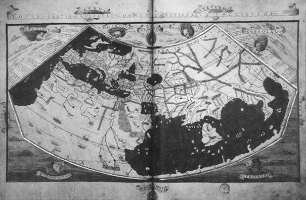
Figure 2.
Claudius Ptolemy, world map. From the Geographia (Rome, 1472). Courtesy of the American
Geographical Society Collection, Milwaukee, Wisconsin.
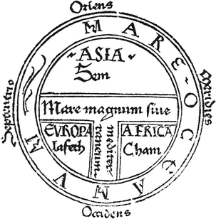
Figure 3.
Isidore of Seville, T-O mappamundi, 1472. Courtesy of the
Newberry Library, Chicago.
extremity, instead of the North. The T, which crossed at Jerusalem, represented the rivers and seas separating the three known continents. The image was oriented vertically, with its ideological meridian connecting the center at Jerusalem with the Earthly Paradise at the apex of the map. A more elaborate variation of the T-O model is the Ebstorf map (c. 1240) which shows Jerusalem at the center, highlighted by the image of Christ, a patch of gold leaf, and the Terrestrial Paradise at the top (Figure 4). A unique feature of this map is the inscription of Jesus' head, hands, and feet at the four cardinal points. The symbolism is clear: the world is Christ's crucified body, Jerusalem his navel, and the limits of the world are bounded and defined by his reach. As David Woodward has noted, the hermeneutical function of the mappaemundi appears to have grown increasingly important and complex.[16] Once simple book illustrations, the maps were, by the fifteenth and sixteenth centuries, placed on the first or second page of a codex, perhaps reflecting the heightened role cartography played in giving the reader an ideological
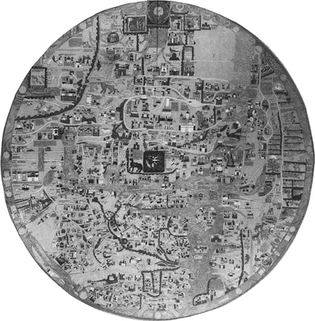
Figure 4.
Ebstorf mappamundi, c. 1240. Courtesy of the William L.
Clements Library, University of Michigan.
preview of the written text. In any case, the relationship between text and map was an intimate one: the text was the source relied on for the verbal directions used to create the map, and the map in turn functioned as a figure of the text.
In this respect mappaemundi were not significantly different from the other medieval cartographic genre, the portolan chart, a term derived from portolano , the Italian word for the written sailing directions. The portolanos are generally considered to be the precursors of the late-fifteenth- and sixteenth-century roteiros (rutters).[17]
The portolan charts were companion pieces to the written directions, which recorded coastal features, ports, islands, winds, currents, distances, and the like, based on practical knowledge obtained through actual travel experience. Like the mappaemundi , the portolan charts were intimately related to geographical writing, and each cartographic genre's pictorial mode of representing geographical objects illuminates the modalities of textual geographies and the travel genres that are informed by them.
Most scholars today assume that written directions guided the drawing of maps. The complementary relation between writing and cartography was underscored by Columbus when he proudly announced to the Crown that he would deliver text and maps representing and confirming his discoveries. He makes his most explicit statement on the twin aspects of the geographer's task in the "Relación del tercer viaje," when he refers to the authorities he consulted in the formulation of his geographical theories as "aquellos qu'escribieron e situaron el mundo" (Varela, 203; those who wrote about and situated the world). To understand the cartographic tradition that informed Columbian geography, we must take a few moments to examine the two cartographic genres—the mappaemundi and the portolan chart—and their ideological and formal differences.
Tony Campbell identifies the main characteristics of portolan cartography as spatial precision, realism, and historical accuracy.[18] The oldest surviving charts, attributable to Genoese mapmakers of the thirteenth century, already demonstrate the desacralized materialistic conception of space that typifies the genre. Both the historical moment in which these charts proliferated (late 1200s to the early 1500s) and their character suggest that they were drawn to satisfy the practical needs of sailors and merchants involved in the increasingly intensive trading activity along the Atlantic coasts of Europe, northwestern Africa, and the Mediterranean and Black seas. They are composed of a single bold and unbroken line which traces the coastal features with such precision that even the oldest charts very closely approximate the actual outlines of the Mediterranean and Black seas. The extant charts are striking in the clarity and exquisiteness with which they depict their intricate coastal geographies. Strings of place-names also helped define toponymically the political and economic contours of the geography. Political jurisdiction and economic importance were highlighted through changes in the color of ink and the use of flags. In this way, portolan cartography
was responsive to historical change as well as to the expansion of hydrographic knowledge. Its range continually widened to accommodate new discoveries and revised content as fresh information became available; in this way, the charts acknowledged time as a dimension in the experience of geographical space.
Although portolan charts vary considerably in the degree of decorative detail they contain, they consistently exhibit an austere realism with respect to their primary objective, the depiction of coastal geography. Decoration typically was limited to internal or marginal areas of the map that contain little geographical information. Decorative elements seem to function simply as embellishment or highlighting, unlike the mappaemundi , where decoration was usually at the behest of an intense geographical symbolism.
The portolan cartographers also depicted imaginary or legendary islands in the Atlantic with the same straightforwardness. Such fabulous names as Legname, Corvi Marini, San Zorzi, St. Brendan's Isles, Brazil, and so forth often appear in the vicinity of known islands like the Canaries and the Azores. Some early rutters even give distances to some of these mythic islands, underscoring the literal way in which these maps were interpreted. An especially striking example of this imaginary insular geography is found on the Pizzigano Chart of 1424 (Figure 5). Starkly functional in appearance and among the least ornamental of portolan charts, the document's portable size and shape, even the way it was rolled for storage, suggest that it was intended for regular practical use, not for display. The Pizzigano Chart was almost certainly created for use in Atlantic navigation, since only those coasts and the westernmost portion of the Mediterranean are represented. Nevertheless, it prominently situates several fantastic islands in the western Atlantic (Antilla, Satanazes, Brazil, Ymana, etc.) in a matter-of-fact fashion difficult to distinguish from that used to depict the real insular geography.
The Canepa Chart of 1489 (Figure 6), as geographically complete and sophisticated as any of its contemporaries, also depicts a legendary insular geography in the Atlantic without distinguishing it from the known islands. According to Ferdinand Columbus, it was precisely the belief in the existence of such islands that reassured his father about the feasibility of the long transoceanic passage (Vida , 51). It is very probable that Columbus employed just such a chart to plan his navigation and illustrate his proposal at court. In fact, the only cartographic drawing we have from his hand, of the
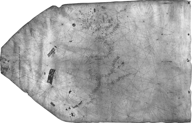
Figure 5.
Zuane Pizzigano, portolan chart, 1424. Courtesy of the James Ford Bell Library, University of Minnesota.
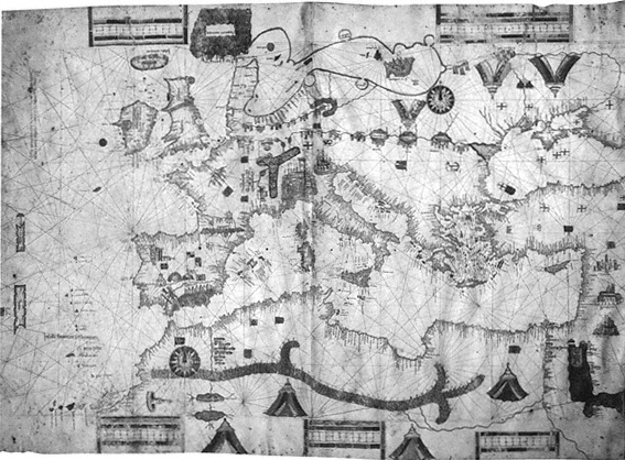
Figure 6.
Albino de Canepa, portolan chart, 1489. Courtesy of the James Ford Bell Library, University
of Minnesota.
northwest coast of Española (Haiti), appears to be a preliminary sketch for an eventual chart and is informed by portolan functionalism, realism, and accuracy.[19] A detailed description of a map of the discoveries composed for the Crown by Columbus has survived in a carta-relación of the second voyage, dated January 1494:
Verán Vuestras Altezas la tierra d'España y Africa y, en frente dellas, todas las yslas halladas y descubiertas este viaje y el otro; las rraias que ban en largo amuestran la ystançia de oriente a Oçidente, las otras questán de través amuestran la ystançia de setentrión en ahustro. Los espaçios de cada rraia significan un grado, que e contado çinqueta y seis millas y dos terçios que rresponden destas nuestras leguas de la mar, catorze leguas e un sesto; y ansí pueden contar de oçidente a oriente como de setentrión en ahustro el dicho número de leguas.... E para que podrán ver la distançia del camino ques d'España al comienço o fin de las Yndias, y verán en quál distançia las unas tierras de las otras rresponden, berán en la dicha carta una rraia que pasa de setentrión en austro, ques vermeja, y pasa por çima de la ysla Ysavela sobrel Tín d'España, allende del qual están las tierras descubiertas el otro viaje, y las otras de agora, de acá de la rraia, se entiende; y espero en Nuestro Señor que cada añmucho abremos de acreçentar en la pintura porque descubrirá continamente.
(Rumeu, 2: 451–52)
Your Highnesses will see the land of Spain and Africa and, in front of them, all of the islands found and discovered on this voyage and the other one; the lines that run lengthwise show the distance from east to west, the others that run horizontally show the distance from north to south. The spaces between each line represent one degree, which is comprised of fifty-six and two-thirds miles that correspond to fourteen and one-sixth of our sea leagues; and thus you can count from west to east, like from north to south, the said number of leagues.... And so that you can see the distance of the route from Spain to the beginning or end of the Indies and see the distance between particular lands, you will find on said chart a red line that runs from north to south and passes over the island of Isabela on top of Tín d'España, beyond which line are the lands discovered on the other voyage, and on this side of the line lie the other ones from [this voyage]; and I have hope in Our Lord that each year we will have to enlarge the map because he will continuously discover [new lands].
What Columbus describes was probably a portolan-style map, similar to the well-known Juan de la Cosa Map (c. 1500), oriented toward the Atlantic from the west coasts of Europe and Africa, and including all of the already-discovered insular geography in the western Ocean Sea, a region that on pre-Discovery charts had also been depicted, but only hypothetically.[20] Columbus's chart included lines of longitude and latitude, according to his description, that facilitate a more accurate assessment of distances, and a red line passing through Isabela marks the boundary between the discoveries of the first and second voyages. Just as portolan charts expanded and evolved in response to new information, so Columbus's map, he anticipates, will grow yearly when new discoveries come to light.
In contrast to the realism of the portolan genre, the cartographic discourse of the mappaemundi is characterized by its figurative dimension. A rubric on the Ebstorf map illuminates this aspect, underscoring the image's anagogical significance: "A map is called a figure, whence mappamundi is a figure of the world."[21] The body of Jesus inscribed on this map is a particularly clear example of this function: the disk containing the world, which is in turn contained by the body of Jesus, can be interpreted iconically as the Host, symbolizing the communion of all nations in the body of Christ. Whatever real geographic information these maps may contain, their primary function is hermeneutical; the representation of geographical reality is subordinated to the promotion of a particular spiritual interpretation of the world.
Mappaemundi also appear to have played an important role in the motivation of spiritual forms of travel. The Haldingham map in the Hereford Cathedral was periodically expanded by its makers, who added place-names taken from various written itineraries of religious travelers. Such a map could have served both the commemorative purpose of recording actual pilgrimages and the rhetorical one of stimulating new travelers to undertake a like journey by providing a model for emulation and planning. Whatever the purposes of such emendations, the map itself is a figure of the spiritual goals and significance of the journey. Mappaemundi defined a geography whose essentially figurative, schematic, ahistorical character could hardly have served the traveler's practical needs for precise directions or distances. Yet the promise of redemption they proclaimed in their metaphorical ordering of spaces—for example,
situating the favored destinations of real and mystical pilgrimages (Rome, Jerusalem, and the Terrestrial Paradise) on the same ideological meridian—encouraged the traveler toward his or her destination, itself a figure of the spiritual goal. These maps, although they may appear absurdly fanciful to the modern viewer, were responsive to the purposes for which they were designed: the promotion of a Christian ideology of space and the stimulation of real and imaginary spiritual voyages which would enact that ideology through actual or imaginative experience.
Although cartography may seem the most static and atemporal of discourses, maps are nevertheless profoundly chronotopical; they represent time-space in an ideologically coherent image of the world (understood as a spatiotemporal reality, as in the phrase "the end of the world"). For example, portolan geography is so inscribed in a particular historical moment that the temporal coordinates of undated portolan charts usually can be approximated with a considerable degree of accuracy. Moreover, their historical realism and toponymic specificity mirrors the literalism of the portolano and the temporal exactingness of later rutters. When these maps are read in conjunction with the written record of the voyage they were intended to complement, their functional temporal character intensifies as each location on the map acquires a concrete time value in relation to every other relevant point on the trajectory. From this perspective, every location becomes a time-space coordinate of the navigation as well as a place existing at, and significant at, a sgpecific historical moment. Mappaemundi are equally, although distinctively, chronotopic. In contrast to the functionalism and materialism of portolan charts, they represent a metaphysical view of time-space, a spiritual chronotope, that is defined by the spatial continuity between Earth and the Other World (Heaven or Hell) and the secular-sacred temporal continuum that is the history of salvation. Time and space are conceptualized as essentially limitless, bounded only by the figure of Christ, the measure of whose infinite and eternal reach defines the spatiotemporal contours of the Ebstorf map.
The term mappamundi was also used generically well into the eighteenth century to mean a verbal geography, a usage that further blurs the distinction between text and map. In implying that the geographical text is like a map, the metaphorical acceptation suggests that just as writing helped define cartographic images, so did
maps influence the articulation of spatiotemporal fields in texts. From this point on, I will use the term "textual cartography" as shorthand for the notion that maps informed the chronotopes of geographical writings, just as writing informed the chronotopes of cartography, from the Middle Ages and into the modern period.[22] To put it another way, geographical texts construct time-space much in the way maps do, and in their articulation of space, journeys reflect the particular cartographies that inform them. Map and text are thus complementary and even indispensable modalities for articulating the discovery experience.
Approaching the Columbian texts from this perspective offers two important advantages. First, by conceiving the geographical image as the product of a particular type of experience, we can discuss the geographical and epistemological aspects of the Discovery as related issues. Second, this reading strategy, akin to the practice of placing maps in the opening pages of a book to guide the reader through the textual cartography beyond, matches the strategy of representation favored by Columbus in the prologue to the Diario :
También, Señores Prínçipes, allende de escrevir cada noche lo qu'el día passare y el día lo que la noche navegare, tengo propósito de hazer carta nueva de navegar, en la cual situaré toda la mar e tierras del mar Occéano en sus proprios lugares, debaxo su viento, y más componer un libro y poner todo por el semejante por pintura, por latitud del equinocial y longitud del Occidente.
(Varela, 17)
Also, my Lord Princes, besides writing down each night whatever I experience during the day and each day what I sail during the night, I intend to make a new sailing chart. In it I will locate all of the sea and the lands of the Ocean Sea in their proper places under their compass bearings and, moreover, compose a book and similarly record all of the same in a drawing, by latitude from the equinoctial line and by longitude from the west.
(Dunn & Kelley, 21)
Once a mapmaker by trade, Columbus took pride in his cartographic skills long after his successes as a mariner and discoverer had made him a name.[23] In a letter addressed to the Catholic Monarchs (1501) included in the Libro de las profecías , he boasted of his God-given abilities:
A este mi deseo fallé a Nuestro Señor muy propicio y ove d'El para ello espírito de inteligençia. En la marinería me fiso abondoso, de astrología me dio lo que abastava y ansí de geometría y arismética y engenio en el ánima y manos para debusar espera, y en ella las çibdades, ríos y montañas, islas y puertos, todo en su propio sitio.
(Varela, 277)
For this my purpose I found Our Lord very favorable and he gave me the intellectual enlightenment for it. In seamanship he endowed me generously, in astrology he gave me what was necessary and likewise in geometry and arithmetic, and the talent and hands to draw a sphere and upon it cities, rivers and mountains, islands and ports, all in their proper place.
That Columbus consulted maps of various kinds to plan and carry out his navigations is obvious, but it is also quite likely, as Paolo Revelli has noted, that aboard his vessels were both portolan charts of the eastern Atlantic and mappaemundi depicting the uncharted Asiatic geography of the western Ocean.[24] In any case, numerous references by Columbus to both of these cartographic genres in the accounts of the voyages confirm that he sailed with two very different cartographic images in mind: a portolan one, which guided the navigation, and a hermeneutical one, which aided him in interpreting the nature and significance of the new geography he was encountering. The two following passages concern the same insular geography, but the first is informed by a practical portolan cartography, the second by the spiritual paradigms of the mappaemundi :
Este día ovo mucha calma y después ventó, y fueron su camino al Güeste hasta la noche. Iva hablando el Almirante con Martín Alonso Pinçón, capitán de la otra caravela Pinta, sobre una carta que le avía enbiado tres días avía a la caravela, donde, segund pareçe, tenía pintadas el Almirante ciertas islas por aquella mar, y dezía el Martín Alonso que estavan en aquella comarca, y respondía el Almirante que así le pareçía a él; pero puesto que no oviesen dado con ellas lo devían de aver causado las corrientes, que siempre avían echado los navíos al Nordeste, y que no avían andado tanto como los pilotos dezían. Y estando en esto, díxole el Almirante que le enbiase la carta dicha, y enbiada con alguna cuerda, començo el Almirante a cartear en ella con su piloto y marineros.
(Varela, 24)
This day there was much calm and later it blew and they went on their way west until night. The Admiral began talking to Martín Alonso Pinzón, captain of the other caravel, Pinta, about a chart that he had sent to him on the caravel three days before, on which the Admiral had apparently drawn certain islands in that sea; and Martín Alonso said that they were in that region and the Admiral answered that so it seemed to him, but since they had not encountered them it must have been caused by the currents which always had driven the vessels northeast and that they had not traveled as far as the pilots said. And at this point the Admiral said to send the said chart to him. And it having been sent over by means of some cord, the Admiral began to plot their position on it with his pilot and sailors.
(Dunn & Kelley, 41–43)
Maravillóse en gran manera de ver tantas islas y tan altas y çertifica a los Reyes que desde las montañas que desde antier a visto por estas costas y las d'estas islas, que le pareçe que no las ay más altas en el mundo ni tan hermosas y claras, sin niebla y nieve, y al pie d'ellas grandíssimo fondo; y dize que cree que estas islas son aquellas innumerables que en los mapamundos en fin de Oriente se ponen. Y dixo que creía que avía grandíssimas riquezas y piedras preçiosas y espeçería en ellas, y que duran muy mucho al Sur y se ensanchan a toda parte. Púsoles nombre la mar de Nuestra Señora. Dize tantas y tales cosas de la fertilidad y hermosura y altura d'estas islas que halló en este puerto, que dize a los Reyes que no se maravillen de encareçellas tanto, porque les çertifica que no dize la çentessima parte: algunas d'ellas que pareçía que llegan al çielo y hechas como puntas de diamantes.
(Varela, 57–58)
He marveled greatly to see so many and such high islands, and he assures the sovereigns that it seems to him that there are no higher mountains in the world than those he has seen since day before yesterday along these coasts and on these islands, nor so beautiful and clear, without mist or snow; and at their feet very great depth. And he says that he believes these islands are those innumerable ones that in the maps of the world are put at the eastern end. And he said he believed that there were great riches and precious stones and spices in them, and that they extend very far south and spread out in all directions. He gave them the name Mar de Nuestra Señora... [In contrast to Varela, Dunn and Kelley insert a note from the margin in the text proper at this point.] He says so many and such things about the fertility and beauty and height of these is-
lands that he found in this harbor that he says to the sovereigns that they should not marvel that he praises them so much, because he assures them that he believes he does not tell a hundredth part. Some of them appear to reach the heavens and are formed like points of diamonds.
(Dunn & Kelley, 153–55)
These two passages exemplify the conceptual cartographic models available to Columbus for describing geographical spaces and the discursive transformation that takes place when one cartographic genre or the other informs the representation of the new geography. In the first passage, the articulation is informed by a navigational cartography, akin to that of the portolan chart on which the Admiral was plotting the fleet's course in order to find landfall. In the second passage, Columbus is relating to the Crown his interpretation of the significance of the geography he has experienced. The newly sighted islands are identified with the innumerable (hypothetical) islands that the mappaemundi situate at the end of the Orient. Consequently they are endowed with the poetic and spiritual inflections that characterize Christian orientalist geographical discourse. They are islands of ineffable wealth, beauty, and fertility, so extraordinary that a literal description does not suffice and the islands assume the metaphorical shape of diamonds rising toward heaven. Their spiritual value is inscribed symbolically in the name he gives them, Mar de Nuestra Señora (Sea of Our Lady), as he practices an onomastic cartography, tracing the route of the voyage through a figuratively Christian landscape that marks the continuity between this world and the Other.
Exploration
Samuel Eliot Morison, following Las Casas and Ferdinand Columbus, called attention to the importance of the Portuguese precedent in the early conceptualization and formulation of the enterprise of the Indies.[25] It was Las Casas, however, who provided perhaps the strongest evidence for the idea that Portugal's early explorations in the eastern Atlantic were intellectually decisive and provided the practical motivation for Columbus's enterprise. As Las Casas tells it in the Historia (bk. 1, chap. 13), the story Columbus heard from Pedro de Velasco, a Portuguese pilot who told of lands he had
sighted to the west of Ireland, provided a decisive stimulus for the first voyage. Biographers have often discussed Columbus's years in Portugal (1478-c. 1485) and his service on Portuguese commercial expeditions along the African littoral in search of an eastern sea route to India as the inspiration for his idea to sail west to reach India faster. Morison, in particular, has noted the knowledge of westerly winds and currents Columbus must have obtained on those African voyages, knowledge that made his Atlantic crossing a success where others had failed. Yet the relevance of Portuguese nautical and maritime writings to Columbus's articulation of the voyages to the Indies has received little attention. Scholarship on the Discovery typically has ignored the Columbian texts' important place in the history of travel literature even while focusing on their contribution to the history of travel.
João Rocha Pinto, in his study A viagem: Memória e espaço , has shown that Portuguese maritime travel literature of the so-called Age of Discovery, roughly encompassing the fifteenth and sixteenth centuries, employed a variety of distinct forms, ranging from listlike and highly technical writings (e.g., sailing directions, rutters, navigation manuals and guides) concerned with navigation as spatial displacement or movement (how to get from here to there) to more narrative and descriptive forms (e.g., relations, letters, voyage diaries) concerned with the voyage as an experience. Rocha Pinto suggests that the earlier forms emphasized the spatial aspects of the journey, while the most temporally oriented of forms, the diario de bordo , he argues, did not appear until the mid-sixteenth century.
The earliest Portuguese navigation guides, the roteiros (rutters), were composed of concrete technical directions on the route, astronomical observations, winds and currents, compass readings, coastal features, and so on. Some roteiros of specific voyages (e.g., "Roteiro da viagem que Dom Jhoão de Castro fez a primeira vez que foy a India no ano de 1538") began to follow a systematic chronology in the recording of the voyage. In contrast, more traditional rutters, like the Spanish "derrotero general" found in Alonso de Chaves's "Espejo de navegantes" (c. 1537), which has been described as a navigational chart in prose, contained virtually no temporal elements.[26] Like the charts they accompanied on board exploration vessels, traditional rutters served the practical needs of navigators for tracing the coordinates of the route and the contours
of the geography traversed.[27] The "how-to" quality and the systematic, detailed character of the entries describe a rigorous verbal map of the navigation that renders each location on the itinerary significant in relation to the trajectory of the journey as a whole.
By the late sixteenth century the temporalization of space in the writings generated by the voyages of exploration was fully achieved, as Adriaen Veen's instructions for composing a roteiro (1597) make clear. Among the genre's essential components, Veen lists the recording of the year, the month, the day, the time of day, as well as the transitions from one to the next; for example, from ante to post meridian).[28]
While Rocha Pinto seems to be correct in asserting that rigorous chronology was not introduced into European nautical literature until later in the sixteenth century, it does not necessarily follow that earlier works were not temporally sensitive. The earliest surviving roteiros of Portuguese exploration of the African Atlantic, dating from the late fifteenth century, were indeed essentially devoid of temporality. They were typically not intended as accounts of specific navigations, but as directions to be followed by future mariners. Once narrative elements enter the accounts, however, so too does time, for narration is, by definition, an intensely temporal form of writing, establishing meaningful sequences and relations among a series of events or experiences.
Narrative, however, is a rare commodity among the early writings of European maritime exploration. The oldest Portuguese nautical texts, such as the one known today as "Este livro é a rotear...," collected by Valentim Fernandes in the early sixteenth century, or the "Roteiro de Flandres," collected in João de Lisboa's Livro de Marinharia later in that same century, exhibit only the most rudimentary of narrative qualities in order to represent the succession of noteworthy geographical and hydrographic phenomena.[29] The same can be said of the oldest surviving French routier , written by Pierre Garcie in 1483–84.[30] To call them narratives, however, would be to stretch to the breaking point the limits of the definition. Yet there are important examples of narrativization among the earliest writings associated with the Portuguese voyages of exploration of the African littoral. For narrativization (and therefore temporalization) is a fundamental characteristic of any travel literature whose purpose is to relate the subject's experience of geographical space,
rather than just describe the existence of places independent of the writer.[31] The Valentim Fernandes collection (c. 1506–1508) contains descriptions and a chronicle of the African discoveries. Duarte Pacheco Pereira's Esmeraldo de situ orbis (c. 1505–1508) and two mid-fifteenth-century accounts of the African voyages by Italians who sailed with the Portuguese, Alvise Ca' da Mosto and Antonioto Usodimare, all represent not only the physical contours of space but, especially, the subject's experience of it.[32]
The Esmeraldo is a particularly interesting case, for although it has been described as primarily a roteiro , Pacheco blends a variety of genres to constitute space through his own experience of seascape and landscape. His text reads variously like history, a treatise on cosmography, a book of seamanship, an ethnographic description, and a commercial journal, all of which have been inscribed onto the basic structure of the nautical guidebook.[33] It is not always clear to what extent Pacheco is reporting his own experiences or giving secondhand reports, but throughout he subjectifies the atemporality and strict objectivity of the roteiro to represent a geography mediated by the intervention of the human consciousness that renders it meaningful.[34]
The increasing tendency to temporalize space had profound implications for the relation of exploratory travel to knowledge, and for exploration as an epistemological phenomenon.[35] Not only did it represent a shift from writing the voyage as charting or marking the boundaries of an unknown space to telling the story of the voyage as a narrative sequence of events (a historical phenomenon); it further implied that maritime exploratory travel writing had become a way of relating the explorer's experience (in time) of space—of becoming familiar with, of interacting with, of knowing a previously unknown space.[36] Ultimately, the temporalization of space in exploratory travel writing rendered it fully chronotopic, thereby transforming it from a technical to a cultural discourse.
The chronotopic values that characterize portolan cartography—spatial precision, realism, and temporal accuracy—have their scriptural counterparts in the roteiros, diarios de bordo , and relaçãos of the Age of Discovery. Just as exploration produced maps that defined the historical and physical outlines of previously unknown spaces, the written texts fully constituted a spatiotemporal field that gave meaning to the explorer's unprecedented experience of the journey
through the new geography. Perhaps the earliest surviving navigation account with these characteristics is Alvise Ca' da Mosto's (1433–77) account of his voyages to Guinea with Portuguese expeditions in the mid-fifteenth century. In the preface to the journey narrative proper, Ca' da Mosto explains the purpose of writing: to record his experiences of the unknown Ocean and lands of "Lower Ethiopia" beyond the Strait of Gibraltar, which had never before been visited by Europeans.[37] The new lands are compared to the world familiar to his readers so that, as he puts it, his descendants may know his reasons for seeking diverse things in various and new places. As one reads a bit further, it becomes clear that Ca' da Mosto's "discovery" is motivated both by curiosity (the desire to see the marvels of strange lands and peoples) and by the promise of economic profit (the spices, gold, and other valuable things potentially to be found there). The experience of discovery is inscribed by Ca' da Mosto in the discourses of mercantilism and exploration, structured within a journey whose spatiotemporal field is represented as realistically as possible—wholly appropriate to an author who is credited with composing the oldest surviving portolano , printed in Venice in 1490. The text is characterized by a pragmatic, materialistic, quantitative mode of diction that strives to render the experience specifically, concretely, and objectively.
In the Columbian corpus, the Diario of the first voyage stands out as the most typical exploratory nautical writing. Las Casas's undeniable hand in the shaping of the text that has come down to us notwithstanding, the basic structure and diction of the Diario are closely related in form and function to the roteiro genre.[38] For the first forty-two days of the voyage, the text records technical navigational information regarding direction, speed, winds, currents, and other maritime phenomena relevant to the successful completion of the voyage. These data, organized in listlike fashion, provide the framework for a basic chronology of daily entries. The predominant organizational principle within these segments, however, is spatial, responding to the practical necessity of keeping a precise record of the distances traveled by the fleet. The daily subdivisions no doubt reflected the expectation that the fleet would be sailing out of sight of land for long intervals. Navigation on the high seas required a systematic recording of location in relation to fixed points, but astronomical navigation was still only an embryonic science at best.
In the absence of a topography against which to establish position, elapsed time was the only way to record the route. Such a record was especially important for the first voyage since Columbus anticipated sailing in uncharted waters and thus his own observations would be the only guide available for the return course.
With the landfall entry of 11 October 1492, however, the Diario increasingly emphasizes the temporal dimension of the journey. Although the entries continue to record the route, they begin to focus, like Ca' da Mosto's account, on the events of the voyage as the coherent experience of the individual consciousness of the narrator-navigator. Each day's entry is no longer a mere collection of navigational data marking a particular point on an itinerary, but a spatiotemporal field where the journey as process and event unfolds. Each entry is a narrative segment, a portion of the story of the voyage that not only tells where Columbus happened to be and the route he followed to get there, but also places the significance of that particular geography (i.e., what occurred there) in the context of the unfolding larger voyage experience.
The organization of information along chronological lines, even in highly sophisticated chronologies, does not constitute in and of itself a radical departure from writing as enumeration, characteristic of the Diario up to 11 October, and the technical nautical genres that inform such writing. The temporalization of space is accomplished not by the simple addition of temporal units to the spatial record but, as I noted earlier, by the narrativization of the accounting of the voyage. Mary B. Campbell's observations regarding a similar development in the pilgrimage travel literature of the early Middle Ages may help to clarify this distinction. Referring to the listlike itineraries of pilgrimage to the Holy Land, Campbell notes that "In the list all the places are simultaneous and perpetual. They bear no relation to the traveler, and only the spatial relation of distance to each other. The list is in no sense literature; it is an aggregation of data. Literature, anonymous or signed, 'popular' or 'serious,' is the imprint of a human mind on such data, an imprint that imposes a pattern of relations, attempts to make sense."[39]
In narrativizing technical nautical writing, the Diario imposes a pattern of relations among the geographies of "here" and "there," New World and Old. Thus, the reader encounters not so much a "navigational chart in prose," as a culturally inflected discourse
whose purpose is to give meaning to the voyage by relating the narrator's subjective experience of it. The shift from enumeration to narration in the entries after the landfall not only reflects the more complex information to be recorded once the fleet sighted the island of Guanahaní (San Salvador) but also marks a fundamental change in the way the voyage was conceptualized. To discover was no longer simply to find something and record its location; discovery had become a way of knowing what was found.[40]
The reactions of some of the earliest and most interested readers of Columbus, the Catholic Monarchs and Bartolomé de Las Casas, suggest that the text before them was not quite what was expected from the Admiral. Isabella wrote to Columbus in September 1493 requesting the "carta de navegar" and "pintura" he had promised to send with the written account of the first voyage. That what Columbus had presented was deemed unsatisfactory and somewhat baffling is confirmed by another letter dated the same day, this time from both Ferdinand and Isabella, asking for additional navigational information "para bien entenderse mejor este vuestro libro" (so that this book of yours might be better understood).[41]
Another clue to the text's irregularity vis-à-vis traditional nautical genres is found in the unusual nomenclature Las Casas employed in referring to it.[42] In his editorial remarks introducing the narrative portion of the Diario (beginning with the 11 October entry), Las Casas refers to his source as the "libro de su primera navegaçión y descubrimiento d'estas Indias." The use of the adjective "estas" (these) is often quoted to support the argument that Las Casas transcribed the text while living in the Indies. More striking, to my mind, is the peculiar phrasing, which suggests that navigation and discovery were different activities, or distinct genres, in Las Casas's mind. That he added the qualifier "y descubrimiento" suggests that the traditional nautical genre "libro de navegación" was too narrow a category for what Columbus had written.
The typical diario de bordo , according to Rocha Pinto, was completely divorced from the general voyage experience.[43] He describes the diario de bordo as a specialized genre, concerned with organizing the writing of the voyage along strict chronological lines and with recording practical, technical, and scientific information related exclusively to the navigation proper, such as winds, currents, atmospheric phenomena, distances and directions, compass variations,
coastal topography, and latitudes and longitudes. The Diario of Columbus's first voyage includes all the above, and much more.[44] The text tells at least two different, yet related stories: one about exploration and demarcation of a previously unknown and uncharted geographical space, and another about the significance of the voyage to a destination constituted in the text as familiar (already known). It articulates navigation and discovery, as Las Casas recognized, as distinct operations. That the "unknown" space in question was the route, and not the destination, is made clear in the prologue:
Vuestras Altezas ... pensaron de enbiarme a mí, Cristóval Colón, a las dichas partidas de India para ver los dichos prínçipes ... y ordenaron que yo no fuese por tierra al Oriente, por donde se costumbra de andar , salvo por el camino de Occidente, por donde hasta oy no sabemos por cierta fe que aya passado nadie .
(Varela, 15–16; emphasis added)
Your Highnesses ... thought of sending me, Christóbal Colón, to the said regions of India to see the said princes ... and you commanded me that I should not go to the East by land, by which way it is customary to go , but by the route of the West, by which route we do not know for certain that anyone previously has passed .
(Dunn & Kelley, 19; emphasis added)
Rocha Pinto's observation that the temporalization of space in nautical literature was not fully achieved until at least the mid-sixteenth century further underscores the novelty of Columbus's account of the first navigation.[45] Moreover, unlike the typical diario , which Rocha Pinto describes as a strictly technical writing, the Columbian Diario blends an account of the navigation with the Admiral's testimony of the subjective experience of the space encountered. To my mind, it is precisely such testimony that makes it, as Las Casas labeled it, a book about navigation and discovery. What renders the particular geography of the Discovery meaningful is not its precise navigational coordinates, but the relations established by the narrator between "here" and "there." The "libro" Columbus sent to the Crown, as the sovereigns' requests for more geographical and navigational information appear to confirm, was not exclusively (perhaps not even primarily) concerned with the accurate marking of the route within the precise contours of a roteiro -like ge-
ography. It has been argued that the Crown's requests and the journal's deficiency with respect to technical information suggest duplicity on Columbus's part: that he purposely suppressed such information in order to keep knowledge of the route, and thereby any subsequent voyages, for himself alone. Yet analysis of Columbian discourse shows that the first voyage through the Indies is articulated as the experience of a geography profoundly resonant with the cultural, political, and economic ideologies of the late fifteenth century.[46] Starting with the entry of 11 October 1492, the Diario increasingly subordinates technical nautical modes of discourse in favor of modes that emphasize the subjective experience of space.
In the texts relating the first and second voyages, the qualities that describe the journey experience are predominantly sensorial, practical, and secular, as we have seen. The names with which Columbus marks the surface of his verbal map may be of a religious origin, but they usually represent physical similarities between known and new things rather than spiritual affinities or significances:
Desta ysla vine a la otra de Santa María de Monsarrate, que era a la distançia de çinco leguas, tierra es mui alta y conforme a Monsarrate [sic, for Montserrat], y desta vine de una en otra corriendo a mi camino, poniéndoles a cada una nombre, y porque asçinden a gran número, a todas juntamente las nombré de Todos los Santos.
(Rumeu 2:450)
From this island I went to the other one named Santa María de Monsarrate, which was at a distance of five leagues, the land is very mountainous and similar to Monsarrate, and from this one I went from one to the next following my route, and to each I gave a name, and because their number climbed to so many, to the lot I gave the name of All Saints.
Though the European Montserrat, a jagged mountain northwest of Barcelona, was a place of profound spiritual importance—the site of a Benedictine monastery erected to commemorate a miraculous appearance of the Virgin and a popular destination of pilgrims seeking the Virgin's intercession—Columbus's explanation for naming the Caribbean island after Montserrat is only that its peaks physically resemble those of the Catalonian mountain. Likewise, he names the group of islands All Saints simply because there are so
many of them. Not only is there no spiritual significance in this use of religious names, but the very suggestion that the pantheon of Catholic saints is so large as to resemble the proliferating islands in Columbus's path borders on irreverence.
The motivation for the journey as expressed in these early accounts is often unabashedly practical and profane: to find gold, spices, and other commodities. Consequently, the route and map Columbus traces is the one he believes will most likely lead to those resources. In the carta-relación of January 1494 he explains why he pursued a particular route of exploration on the second voyage:
Yo me acuerdo quel año pasado un yndio viejo, aquí en esta ysla Ysavela, me dixo que en estas partes de los caníbales avía una ysla pequeña y que los tres quartos eran oro, y agora conforma, porque yo beo la tierra para ello dispuestas [sic].
Todas estas islas, que agora se an fallado, enbío por pintura con las otras del año pasado y todo en una carta que yo conpuse, bien con harto travajo por las grandes mis ocupaçiones del asiento que acá se faze de la villa.
(Rumeu 2:451)
I recall that last year an old Indian, here on this island of Ysavela, told me that in this region of the cannibals there was a small island and that three-quarters of it was of gold, and now it all makes sense because I see the land disposed to it.
All these islands which have now been found I am sending you in a drawing along with last year's, all of them together on a chart I made, with quite a lot of effort owing to my many responsibilities pertaining to the foundation of the town that is underway here.
The desire to seek out the islands of the Carib Indians ("caníbales"), notorious for their anthropophagy, is none other than that they were reputed to be gold-bearing, as Columbus understood it from a cacique during the first voyage. Indeed, almost without exception, the actions undertaken during the second voyage are related to this materialistic quest. Even the capture of Cahonaboa, the cacique reputed to own the largest pieces of gold on Española and suspected to have been responsible for the deaths of some of the Spaniards left at La Navidad on the first voyage, is ultimately motivated by the search for gold, "porque sabremos dél toda la verdad y de toda la ysla y de oro" (Rumeu, 2:481; because we will learn the whole truth from him and about the entire island and the gold).
The journey of exploration is thus propelled by the worldly goals of the enterprise—to establish a colony for the exploitation of indigenous resources. And the resulting verbal "chart" marks the route of gold through a textual geography that literally is "mined" with references to its potential wealth: "Ya dixe que las tierras, queste viaje se an descubierto, son tantas y más quel año pasado y no de menos preçio como la pintura hará manifiesto" (Rumeu, 2: 462; I already said that the lands discovered on this voyage are as many and more than last year and no less valuable, as the map will show).[47]
Even from a cursory glance at Rocha Pinto's typological synopsis of Portuguese voyage literature, one easily recognizes the filiation of Columbus's writings. The generic models Columbus would have had most immediately in mind were undoubtedly those he became familiar with aboard Portuguese commercial vessels and through other activities related to his African voyages of the 1480s, or perhaps even earlier in the chartmaking business he operated with his brother Bartolomé in Lisbon in the late 1470s. As Ferdinand tells it, Columbus's Portuguese mother-in-law was an early source of maritime writings, charts, and maps for the future Admiral of the Ocean Sea. Dona Isabel's deceased husband, Bartolomeu Perestrello, had held the hereditary captaincy of the island of Porto Santo near Madeira. According to Ferdinand, Perestrello's collection of sea charts and texts was given to Columbus by Dona Isabel when she learned of his interest in navigation.
Columbus's own writings, however, move well beyond such technical nautical genres as the roteiro, the livro de marinharia (book of seamanship), and the livro de armação (book of chandlery).[48] Strong narrational and descriptive qualities link the Columbian texts to relations, letters, memoirs, and journals—genres that did not flourish until later in the Age of Discovery—and the texts also incorporate various judicial forms (contracts, testaments, instructions, petitions, etc.), not to narrate the voyage experience itself, but to complement the pragmatics and ideology of the voyages and articulate the larger enterprise of discovery.
The first voyage, as recounted in the Diario , could be described as a hybrid composed of characteristic elements of such genres as the rutter, the relation, the memoir, and the navigation logbook, and often blending technical nautical, geographical, economic, eth-
nographic, judicial, and religious modes of diction.[49] Two other versions of that voyage are found in the "Carta a Luis de Santángel" (15 February 1493) and the "Carta a los Reyes," both of which offer similar accounts. The letters have much in common with the Diario , yet they are clearly of very different filiation since they forego the technical nautical elements and strict chronology evident in the Diario in favor of a general descriptive content.[50] The letters strike the tone and tenor of a personal epistle geared to the nonspecialist. Their primary purpose appears to be promotional, announcing triumphantly the completion of the voyage by highlighting its most notable and least technical aspects.
Rumeu de Armas's recent publication of Columbus's Libro Copiador has made available for the first time to modern readers Columbian accounts of the second voyage (1493–96).[51] In four relaciones addressed to Ferdinand and Isabella, Columbus records in considerable detail his thoughts and experiences concerning the establishment of the colony on Española, the exploitation of the Indians and the islands' natural wealth, the continuing search for the empire of the Grand Khan, relations among the Christians and between them and the Indians (including the capture of the cacique Cahonaboa and the skirmishes between his people and the Spaniards), the disastrous fate of La Navidad, and, especially, the obsessive search for gold. Another surviving text of this voyage is Columbus's "Instrucción a Mosén Pedro Margarite" (9 April 1494), his instructions to the head of a scouting party charged with the reconnaissance of the interior of Española. The instructions to Margarite, akin to those Columbus himself received from the Crown for each of the voyages, set forth the Admiral's orders and the practical manner in which they should be carried out.[52]
The third voyage is told primarily in the "Relación del tercer viaje," addressed to the Crown, and in a portion (30 May–31 August 1498) of a since lost diario of the same voyage excerpted by Las Casas in his Historia de las Indias . (Another version of the "Relación" of the third voyage appears in the Libro Copiador .) Also pertinent to this voyage are the "Carta a doña Juana de la Torre" (c. autumn 1500), governess of the prince don Juan, and the "Carta a los Reyes" (1501), which serves as an introduction to the Libro de las profecías . Parts of the "Relación" appear to have been derived from the missing diario transcribed by Las Casas, but the thrust of the letter is less
to relate the voyage than to interpret its significance, and Columbus quickly moves on from relating the navigation to an impassioned defense of his achievements and a treatiselike interpretation of the ultimate significance of his enterprise. The other letters are highly polemical pieces in which Columbus seeks to establish the merits of his endeavor and to defend himself from the accusations of his ever more numerous detractors. Considered as a group, the letters pertaining to the third voyage could be viewed both as personal epistles recounting Columbus's experiences and as manifestoes that attempt to carve out an ideology of discovery within which Columbus's particular achievements are set and then interpreted. From the third voyage to the end of his life, as he became increasingly embattled with the Crown over his performance, titles, and privileges, Columbus also became quite prolific in producing letters and legal documents to complement the accounts of his voyages.
Together the later texts yield a picture of a disillusioned and persecuted man struggling to be recognized for his achievements and trying to put his affairs in order before death overtakes him. In the "Relación del cuarto viaje" (7 July 1503), also known as the "Lettera rarissima," Columbus addresses Isabella and Ferdinand from Jamaica, where the sea-battered remains of his fleet had taken refuge at the end of the most difficult and dangerous of his expeditions. The letter's pretext is to report on the voyage and therefore it pays lip service to the forensic-testimonial quality of the relación genre, but it quickly assumes an overwhelmingly plaintive and confessional tone. An anguished petition for recognition and compensation, this relación presents the voyage as a mystical experience with strong messianic and prophetic overtones. The discursive character of these later texts suggests that the generic models of nautical exploration and commerce associated with portolan cartography were superseded in Columbian writing by a quite different textual geography, to which I now turn.
America Twice-Discovered: Columbus Versus Vespucci
In the opening sections of this essay, I drew a distinction between writing about journeys to known places versus unknown destinations. Known places are those already inscribed in the body of
knowledge, sites for which ideological (if not cartographical) coordinates are already in place. In contrast, unknown destinations are those whose semantic field is sparse or empty, a condition by no means restricted to places not even suspected to exist. Yet the designation of a site as "known" is at least as much a function of the way it is articulated as of its objective status. A site's cultural significance, its place and role in the body of knowledge, is ultimately constituted through the very act of writing or mapping it. While different genres may be deemed appropriate to known or unknown places, the choice of rhetorical vehicle is ultimately not imposed from outside the act of writing but from within it. In the final analysis, geographical space is always constituted discursively, as if it were either known or unknown. That is, its discursive character does not guarantee its empirical status. Discourse is, even in its most realistic or factual forms, a position-taking with respect to its object, shaping its meanings and cultural significance beyond its objective condition.
European travel in the fifteenth and sixteenth centuries was usually carried out in regions considered known, not necessarily through the actual experience of travelers, but because the areas had been mentioned in the writings of the auctoritates of classical and Christian antiquity. This was the case with both the Portuguese voyages of exploration along the African littoral and the eastern Atlantic, as well as the so-called New World discoveries, which were not universally considered "new." However, the various rhetorical vehicles available for the articulation of geographical space ultimately responded not so much to the pragmatics and ideology of the voyage as a historical event, but to the scriptural "event" through which the voyage subsequently was interpreted.
The claim of America's novelty, its "discovery" in the modern sense, was the product of a rhetorical tour de force, not of an empirical observation. The dubious honor belongs, as is well known, to Amerigo Vespucci, who in a letter to Lorenzo Pietro Francesco de Medici in the spring of 1503 described the South American mainland as a new world because "none of these countries were known to our ancestors and to all who hear about them they will be entirely new," and even if "they have affirmed that any continent is there, they have given many reasons for denying it is inhabited."[53] Vespucci's claim to the discovery, then, rested not on actually finding
the new continent (although his subsequent phrasing is ambiguous enough to suggest he had), but on the assertion that the ancients had not known its true nature whereas he now did—"But this opinion is false, and entirely opposed to the truth. My last voyage has proved it, for I have found a continent in that southern part; more populous and more full of animals than our Europe, or Asia, or Africa, and even more temperate than any other region known to us, as will be explained further on." The semicolon in the English translation, however, resolves an ambiguity that inheres in the Italian original: whether Vespucci is claiming to have found a new continent altogether or merely a continent more populous than originally thought.[54]
Five years before Vespucci or any other European, Columbus had noted the temperateness of this same mainland and the quantity and quality of its inhabitants.[55] For him, however, it was not a "new" world but an "other" world ("otro mundo"). As he explained in 1498 in a letter to Ferdinand, terra firma is a place "well known to the ancients, and not unknown as the envious and ignorant would have it."[56] The implications of this position are many, not the least important of which is the apparent recognition by Columbus of a fundamental otherness or difference in the physical and cultural landscape he encountered, a question I discuss in the essay that follows, "Gender and Discovery." For the present argument, however, it is necessary to observe that Vespucci's sense of discovery is diametrically opposed to Columbus's position, and it does not seem too farfetched to suggest that it may have been so intentionally and self-servingly. For Vespucci, retrovare meant to discover something previously unknown, at least in the sense that its true nature, if not its existence, had previously been unsuspected. For Columbus, on the other hand, "the Indies" could not be considered new in any sense since many before him had written extensively about it. This land was "other" with respect to the world he and his readers were familiar with; that is, the explored parts of Europe, Asia, and Africa, but it was certainly a world familiar to the writers of classical and Christian antiquity.
This does not mean, of course, that Vespucci and not Columbus discovered America, as some have argued.[57] It does suggest, however, that Columbus "discovered" the territory in a way quite different from Vespucci. Columbus's and Vespucci's respective discov-
eries were ultimately defined by how they were articulated rather than how they were actually carried out or what they yielded. If Vespucci has been given much of the credit for discovering America, certainly it is not because he was the first European to find it or even to write about it (Columbus was), but because he was the first to express it as a new geographical entity; that is, he wrote of his voyage as the story of a journey to a place unknown. The scientific merits of this interpretation were minimal. Were it not for the existence of the Bering Strait, Columbus would have been as "correct" in his basic geographical premise—that he had reached the extreme Orient—as Vespucci turned out to be in his. Neither explorer made a definitive contribution to our knowledge of the true configuration of post-Discovery geography. Yet each made a profound contribution to the ways in which we think about the world. Through his writing, Columbus brought his discovery into cultural being by assigning significance to the journey and its spaces as a voyage to a place already known.
The Grammar of Discovery
Vespucci's sense of discovery as the finding of something new, not previously known to exist, is much closer to the prevailing modern sense than Columbus's notion that the Discovery involved the revelation of something already known but somehow concealed. Columbus's usage, which is deemed an archaism in common speech today, is nonetheless alive in popular symbolic language. The recent tourism slogan "Discover the U.S. Virgin Islands: America's Paradise" defines the modern West Indies by invoking a geographical symbolism that shares some important similarities with Columbus's representation of the Indias Occidentales , the "end of the Orient," as the site of the Terrestrial Paradise.[58] The slogan suggests a way of reading the Columbian texts that runs counter to the tendencies of recent scholarship and is foreign to the prevalent contemporary notion of the Discovery.
The winter-weary resident of northern latitudes is especially susceptible to the allure of the physical pleasures embodied in the slogan's metaphor—perhaps in much the same way as the ocean-weary veteran of an Atlantic crossing might have felt at the close of the fifteenth century. To travel to the West Indies, the slogan im-
plies, is to indulge the senses. Yet the metaphor also promises the traveler a more profound sense of well-being that transcends bodily pleasure to approach a mystical or spiritual rapture. A journey to the paradise of the West Indies promises not only relief from the harshness of winter but a regenerating, purifying experience that will improve the traveler's life, physically and spiritually, after returning home.
Both the slogan and Columbian writing propose a destination of profound symbolic significance and a way of traveling. In each context "discovery" is not so much the locating of an entity (the thing discovered) as a type of activity, not so much a place as a particular kind of experience of place. What defines the discovery in each case is how the traveler relates to his or her destination, the interaction that not only happens there but also helps create the place as a result.[59] The noun descubrimiento does not appear even once in any of Columbus's accounts of the first navigation, though forms of the verb descubrir appear repeatedly.[60] In the slogan, "discovery" assumes the form of an imperative verb, urging the traveler into the experience.
Verbal persuasion—the intention to convince the reader of the merits and benefits of the journey—is another point of equivalence between the slogan and Columbian writing. Both are fundamentally rhetorical vehicles. As Ferdinand Columbus, the man most likely to have been privy to his father's intimate intentions, later explained, his father had called the lands he discovered the Indies, "because he knew all men had heard of the great fame and wealth of India; and by using that name he hoped to arouse the interest of the Catholic Sovereigns (who were doubtful of his enterprise)."[61] The strength of both the slogan's and Columbus's articulation of discovery hinges on the symbolic force inherent in the metaphorical transformation of the West Indies into Eden: the syntactical linking of "discovering" and "Paradise" plays on the reader's imagination. Yet the effect of such phrasing is most immediately to motivate us to imagine a journey (which only later may—or not—lead to actual travel) whose itinerary is figurative rather than literal.
This imaginary journey, a product of the act of reading, is perhaps the most instructive parallel that can be drawn from the analogy. Neither the slogan nor the Columbian texts articulates "discovery" as an empirical feat. In each case "to discover" is to reveal a recondite significance, in the hermeneutical sense of uncovering
a symbolic meaning, not to find a place unknown, since in each case the destination's location is "known" (Paradise appeared on medieval mappaemundi just as certainly as the Virgin Islands do on modern maps). That Columbus's contemporaries understood his discovery in this sense is borne out in the first article of the "Instructions from the Sovereigns to Columbus" (29 May 1493) issued in preparation for the second voyage—"it pleased our Lord God in His blessed mercy to discover the aforesaid islands and mainlands ... by the efforts of the aforesaid Christopher Columbus ... who has made [the islands and mainlands] known to Their Highnesses."[62]
The journey of discovery, then, is first and foremost an imaginative voyage. The traveler to Paradise must move through a symbolic cultural space in order to reach the longed-for destination. By linking discovery and Paradise, the slogan, like Columbian writing, invites us to perform a tropological reading in which the literal sense (Go to the Virgin Islands) is subordinated to the metaphorical spiritual signification (Discover Paradise).[63]
Pilgrimage
If Paradise did exist on this earth of ours, many a man among those who are keen to enquire into all kinds of subjects would think he could not be too quick in getting there: for if there be some who to procure silk for the miserable gains of commerce, hesitate not to travel to the uttermost ends of the earth, how should they hesitate to go where they would gain a sight of Paradise itself?
These words, written by Cosmas Indicopleustes (i.e., Indian sea traveler) in the mid-sixth-century Christian Topography , represent one of the earliest expressions of two fundamental themes of the Columbian discourse of Discovery—commerce and Paradise—significantly linked and valuated by Cosmas to favor the mystical component.[64] I do not intend to argue whether the Christian Topography directly influenced Columbus's writing, but to underscore the strength and durability of these important medieval travel topoi. Commerce and Paradise were still the great motivators of European exotic travel in 1492. Columbus's choice of the term negocio (business) to refer to his enterprise is telling, for it simultaneously alludes metaphorically to the spiritual dimension of the project (i.e.,
negotium crucis ) and literally to its commercial dimension.[65] In identifying economic and spiritual goals as the great motivators of his journey, Columbus was expressing a cardinal aspect of the medieval world view: the interrelatedness of the profane and the sacred, of gold and God.
Travel literature of the period appears to confirm this nexus. As Raymond Beazley has shown in The Dawn of Modern Geography , European travel abroad during much of the Middle Ages was undertaken primarily by Christian pilgrims, missionaries, and merchants. Among the earliest extant works relating a journey beyond the borders of Europe are the fourth-century anonymous "Itinerary from Bordeaux to Jerusalem" and the Peregrinatio ad Terram Sanctam of Egeria. These texts initiate the genre of religious travel literature, known as peregrinationes , focused on the pilgrimage experience. The peregrinationes are roughly of two types: narrations of travel to earthly places of religious import (the Holy Land, Rome, Santiago de Compostela) and mystical voyages to otherworldly sites such as Hell, Purgatory, or Paradise. Although modern readers differentiate the destinations as actual or imaginary, the medieval accounts typically presented both types of pilgrimages as the real experiences of men and women traveling through concrete geographical spaces—in this world or the other—to destinations whose spiritual significance was deemed complementary to the goals of the journey. Paradise and Jerusalem (and often Rome as well) were situated on the same ideological meridian in medieval mappaemundi . The twelfth-century accounts of the pilgrimages made by Saint Brendan and Owein, for example, involve visits to Hell and the Terrestrial Paradise that are articulated as actual voyages through a specific Atlantic geography. Such a blending of mystical experience and real geography became an increasingly important tendency in medieval travel narratives of journeys to the Other World.[66]
As Cesare Segre has observed, the pilgrimages to the Other World often were voyages of discovery, at once physical and spiritual experiences representing the search for self-purification and redemption through practical knowledge of a geography conceived of as simultaneously mystical and real.[67] The Garden of Eden, as Genesis tells us, is located in this world. Its inaccessibility is not due to geographical remoteness but to the divine sanction against Adam and Eve and their progeny. In the medieval voyage narratives, en-
trance to Paradise is a reward granted as a special favor by God to the pilgrim in recognition of a special spiritual achievement.
Even Cosmas, once a merchant-traveler by trade and one of the most prominent figures in the story of early medieval commerce, represented his experience of geography as nevertheless predominantly spiritual. The Christian Topography , written after he became a monk, is instructive for the geographical paradigm it presents as well as for its conception of exotic travel, despite his archaic flat-earth cosmography. Cosmas's attempt to harmonize "science" with religious belief to explain the nature of the world resonates in the Columbian hermeneutics of discovery, and remnants of the mystical semiotics of space depicted in Cosmas's cartographical drawings (among the oldest Christian "maps" to have survived) are evident in Columbian imagery. In Cosmas's highly allegorical sketches, Heaven is represented in the figure of Moses' tabernacle enclosing an earth shaped like a mountain reaching up to the firmament.[68] For Cosmas, the geographer, the ultimate journey was to Paradise, and the true geography was that which interpreted empirical knowledge of the world in light of the authority of the Scriptures.
The two great motivators of medieval travel, although definitely hierarchized, are related geographically and ideologically. According to Cosmas, Paradise was both a place and a symbol of spiritual fulfillment, just as silk was a metonymy for material wealth. Both were traditionally found in the East. Thus Oriental geography was associated with the achievement of spiritual and worldly states of plenitude alike. This association is found already in the earliest articulation of Judeo-Christian geography in Genesis 2:10–12, where the great river that nourishes the bountiful Garden of Eden is also the source of the river Pison, which encircles the gold-bearing land of Havilah "and the gold of that land is good."
The biblical prelapsarian Paradise is of this world and, accordingly, it provides generously for the well-being of human spirit and body alike. The defining characteristic of prelapsarian existence in the Garden is the unproblematic, indeed complementary, relationship between bodily and spiritual gratification. Columbian writing is replete with resonances of this complementary valuation. In the account of the fourth voyage, for example, gold and wealth, presumably through alms and charitable acts, are described as capable of facilitating the entrance into Paradise of souls condemned to pur-
gatory: "El oro es excelentíssimo; del oro se hace tesoro, y con él, quien lo tiene, haçe cuanto quiere en el mundo, y llega a que echa las ánimas al Paraíso" (Varela, 327; Gold is a most excellent thing; gold constitutes treasure, and with it, whosoever possesses it, can do whatever he wishes in this world, even sending souls to Paradise).
The tragedy of life after Eden is not only, or even primarily, that it becomes a struggle for survival in a suddenly hostile world, but especially that it is the struggle of a self suddenly divided against itself, flesh against spirit. For the physical indulgences associated with sinfulness in a postlapsarian world (e.g., lust, greed) had once complemented and enhanced Adam and Eve's spiritual beatitude. The dual spiritual and commercial goals of the Columbian enterprise—to convert new souls to Christianity and liberate the Holy Land with the riches extracted from the Indies—appear to respond to the Christian millenarian yearning for the end of the world and the concomitant restoration of humankind's prelapsarian integrity.
Columbus's conceptualization of his journey to the Orient to spread the Faith and return with gold, spices, and precious stones to help restore Jerusalem no doubt conformed ideologically to this cultural ideal of spiritual and material plenitude associated with the East. The paradisiacal note sounded in the Diario of the first voyage becomes a dominant theme, culminating in the proclaimed discovery of the precise location of the Terrestrial Paradise during the third voyage. This peculiar claim, and the often intensely mystical terms in which it was expressed, has led some modern readers to dismiss it as the product of illness or madness.[69] Yet this theme and Columbus's diction are consistent with both his stated goals for the enterprise and the cultural horizons within which the Discovery took shape.[70] It was no coincidence that after years of advocating his project at various European courts, Columbus was successful at last with the Catholic Monarchs, the self-styled defenders of Christian ideals on the international political stage of late-medieval Europe.
The ideological appeal of Columbus's project for the Catholic Monarchs must have been very strong, for it was known to be technically flawed, as several commissions of experts who considered his proposal repeatedly pointed out.[71] Among the various arguments and rationales that convinced Ferdinand and Isabella to support the plan must have been the economic and political circum-
stances in which Spain found itself at the end of the fifteenth century. The possibility of forming an alliance with the Mongols against Islam had been a feature of Christian policy throughout much of the Middle Ages, as the papal embassies of Plano Carpini, Rubruck, Monte Corvino, and Pordenone in the thirteenth and fourteenth centuries indicate. Spanish political relations with the Far East date from the early fifteenth century, when Henry III of Castile sent his own emissaries on an overland mission to the Tatar emperor Timur. Ruy González de Clavijo, in an account of his own journey in 1403–1406 through the Tatar realm on behalf of the sovereign, writes of the friendliness with which he and the other Castilians in his party were greeted. There is no evidence, however, that any concrete plans for an alliance were ever made. Yet the possibility of such an association remained a feature of Spanish policy until the beginning of modern history. In the letter that has come to serve as the prologue to the Diario , Columbus explicitly affirms that establishing relations with Oriental princes was an important component of the political agenda of his first voyage. Such relations, as would be expected, implied the conversion to Christianity of the princes in question—not by force, Columbus was careful to note, but by request.
The ideological boundaries of the enterprise explicitly outlined in the prologue situate the Columbian enterprise squarely within the Iberian reconquest project, which after over seven centuries had just culminated in the successful siege of Granada. But the Diario entry for 26 December indicates that the voyage had an even more ambitious religious motive in Columbus's mind, the financing of a crusade to liberate Jerusalem from the Muslims:
Y dize que espera en Dios que, a la buelta que él entendía hazer de Castilla, avía de hallar un tonel de oro, que avrían resgatado los que avía de dexar, y que avrían hallado la mina del oro y la espeçería, y aquello en tanta cantidad que los Reyes antes de tres años emprendiesen y adereçasen para ir a conquistar la Casa Sancta, "que así," dize él, "protesté a Vuestras Altezas que toda la ganançia desta mi ernpresa se gastase en la conquista de Hierusalem, y Vuestras Altezas se rieron y dixeron que les plazía, y que sin esto tenían aquella gana."
(Varela, 101)
And he says that he hopes in God that on the return that he would undertake from Castile he would find a barrel of gold that those who were [to be] left would have acquired by exchange; and that they would have found the gold mine and the spicery and those things in such quantity that the Sovereigns, before three years [are over], will undertake and prepare to go conquer the Holy Sepulchre; for thus (says he) I urged Your Highnesses to spend all the profits of this my enterprise on the conquest of Jerusalem, and Your Highnesses laughed and said that it would please them and that even without this profit they had that desire.
(Dunn & Kelley, 291)[72]
The preceding passage is notable for its blending of the material and spiritual objectives of the voyage: the barrel of gold of the Indies for the conquest of the Holy Sepulchre. Such a blurring of the enterprise's religious and secular purposes is reflected throughout the Diario in the articulation of the destination and of the geography experienced throughout the journey. Originally constituted as a commercial enterprise and a political embassy to the Indies of the Grand Khan in the document of commission issued by the Crown in April 1492, the voyage begins to acquire strong religious overtones in the Diario . The human and physical landscapes described by Columbus simultaneously belong to an objective, practical, materialistic geography—Çipango, Zaitón, Quinsay; lands of "grandíssima suma de oro" (a very great quantity of gold)[73] —and a spiritual one, which points to the transcendental anagogical significance of the journey experience. Such toponyms as San Salvador, Santa María de la Concepción, Monte Christo, río de Gracia, Cabo Sancto, Valle del Paraíso, and Mar de Nuestra Señiora name a topography characterized by its edenic qualities and inhabitants who are
gente de amor y sin cudiçia y convenibles para toda cosa, que certifico a Vuestras Altezas que en el mundo creo que no ay mejor gente ni mejor tierra. Ellos aman a sus próximos como a sí mismos, y tienen una habla la más dulçe del mundo, y mansa y siempre con risa.
(Varela, 98)
a loving people, and without greed, and docile in everything. And I assure Your Highnesses that I believe that in the world there are
no better people or a better land. They love their neighbors as themselves, and they have the sweetest speech in the world; and [they are] gentle and always laughing.
(Dunn & Kelley, 281)
The identification of the location of the Terrestrial Paradise in the vicinity of the discovered lands, announced on 21 February during the return voyage, seems almost an inevitable finale to the inter-twining of a figurative paradisiacal geography with the "scientific" and commercial nautical one throughout much of the Diario .[74]
The voyage experience as expressed in the Diario is defined by a chronotope that is constituted through a predominantly objective and systematic chronology linking a sequence of actual points on the navigation's trajectory into a practicable geography. Yet the portolan cartography that plots and traces the course to and through the Indies is by no means perfect.[75] It repeatedly breaks down as the discourse assumes a subjective and figurative cast, rendering Columbus's verbal map an erratic and at times incoherent navigation guide. As the Crown was quick to point out to the Admiral in the letters of September 1493, the account of the first voyage as it was initially presented at court was deemed incomprehensible and in need of considerable supplementation.
Tierra De Gracia
Littera gesta docet:
quid credas allegoria;
moralis quid agas;
quo tendas anagogia.
Jean Gerson, In Decretis , quoted by
Columbus in Libro de las profecías
The literal teaching tells facts:
The allegory tells what you should believe;
The moral interpretation tells how you should act;
The anagogy tells where you are going.
(West & Kling, 101.)
The regrettable loss of the diarios of the second, third, and fourth voyages makes it difficult to trace the development of the textual cartography of the Discovery. In the Diario and letters of the first and second voyages, the portolan chronotope of exploration describes
the journey to the Indies. The spiritual chronotope of pilgrimage, however, begins to make itself felt once Jerusalem and Paradise make their appearance on the face of Columbus's verbal map. Las Casas seems to suggest just such a development in his summary-transcription of the Diario and the "Relación del tercer viaje." When one reads these texts together, as distinct yet integral parts of the larger journey of discovery, one observes how the portolan textual cartography, which prevails in the accounts of the early voyages, is overwhelmed by a figurative spiritual mapping strategy that situates the mainland of Paria (discovered during the third voyage) on the same ideological meridian as Paradise and Jerusalem as they appear on the mappaemundi . What was stated somewhat ostentatiously as a practical goal in the Diario —that the gold and spices of the Indies would pay for the crusade to reconquer Jerusalem from the Muslims—is expressed in ever more mystical terms throughout the account of the third voyage.
Early in the "Relación" of this voyage Columbus renames the mainland of Paria as Tierra de Gracia (Land of Grace), proceeds to describe it as "otro mundo," and explicitly identifies it with lands whose discovery was prophesied by the Old Testament prophet Isaiah. It is unclear from the text exactly which of Isaiah's prophecies Columbus is referring to, but the vague allusion is subsequently explained in the letter to doña Juana de la Torre, written upon his return to Spain from the third voyage: "Del nuevo cielo y tierra que dezía Nuestro Padre por Sant Juan en el Apocalipsi, después de dicho por boca de Isaías, me hizo mensajero y me amostró aquella parte" (Varela, 264; Of the new heaven and earth of which Our Father spoke through Saint John in the Apocalypse, after it was spoken through the mouth of Isaiah, he made me messenger and showed me that place). The profound mystical character of this divinely revealed geography is clarified in the biblical passages Columbus alludes to, which identify the new heaven and earth as the New Jerusalem. In the Old Testament, Isaiah's prophecy of the New Jerusalem is defined by an earthly chronotope: the Messiah will rule in this world, initiating a new period of human history. In the apocalyptic vision of Saint John, the New Jerusalem, the Holy City, functions as a symbol for the salvation of humankind made possible by the Second Coming and the end of this world.[76] The Christian prophecy is characterized by an otherworldly chronotope in which
time becomes eternity and Paradise is the dwelling place of the faithful. In Revelation, Saint John presents a figurative reading of Isaiah in which the earthly Jerusalem of Judaism is treated as a metaphor for the redeemed soul's abode in the Heavenly City. The significance of Columbus's use of the same phrase to designate his discovery of the mainland must be understood in this figurative sense.[77]
If one situates Columbus's onomastics in the context of his textual cartography of the third voyage this interpretation becomes even more compelling. The mainland of Paria, baptized by Columbus as Tierra de Gracia and later referred to as "nuevo cielo y tierra" (new heaven and earth), is rendered meaningful in the context of a figurative voyage trajectory that began in Spain in the year of the fall of the last Muslim city, Granada, to the Catholic Monarchs and was projected to culminate, not with the discovery of the Indies, but with the reconquest of Jerusalem. In the Libro de las profecías , a handbook of prophecies collected by Columbus from various sources (most of them biblical) with the help of his friend Fray Gaspar Gorricio, the discovery of the mainland is interpreted as the decisive point on a prophetic itinerary whose ultimate goal is spiritual.[78]
From this perspective the proposed liberation of Jerusalem and its restitution to Christendom is seen not as an end in itself, but as an essential step in a collective mystical journey whose destination (understood anagogically) is the New Jerusalem, the Heavenly City prophesied in the Bible.[79] Just as the earthly Jerusalem is to be attained by way of the Indies (i.e., through its riches), so must the heavenly Jerusalem be achieved through the restoration of Zion and the evangelization of the rest of the non-Christian world. It is this prophetic journey that Columbus believed he had been divinely inspired to undertake:
Ya dise que para la hesecuçión de la inpresa de las Indias no me aprovechó rasón ni matemática ni mapamundos; Ilenamente se cunplió lo que dijo Isaías. Y esto es lo que deseo de escrevir aquí por le redusir a Vuestras Altezas a memoria, y porque se alegren del otro que yo le diré de Jherusalem por las mesmas autoridades, de la cual inpresa, si fee ay, tengan por muy cierto la victoria.
(Varela, 280)
Already I pointed out that for the execution of the journey to the Indies I was not aided by intelligence, by mathematics or by maps.
It was simply the fulfillment of what Isaiah had prophesied, and this is what I desire to write in this book, so that the record may remind Your Highnesses, and so that you may rejoice in the other things that I am going to tell you about our Jerusalem upon the basis of the same authority. If you have faith, you may be certain that there will be success also in that other project.
(West & Kling, 111)
The Diario had already been explicit on this issue—the gold of the Indies would liberate the Holy Sepulchre—and this assertion is reiterated in the letter of 4 March 1493. The same gold, as Columbus writes in the account of the fourth voyage, would also gain admittance to Paradise (Varela, 327), perhaps in the form of alms, as Varela has suggested or, more probably, as the direct consequence of and divine reward for a sacred crusade by Spain to liberate the Holy Land itself, financed with the riches of the Indies.
In the textual cartography of the third voyage, the Indies is not only on the figurative way to Jerusalem, it is also in the vicinity of Paradise. Such a geography makes sense only in the context of a paradigmatic cartographic discourse in which spatiotemporal coordinates are determined ideologically rather than empirically. Columbus describes the voyage's trajectory from west (Spain) to far east (the presumed Asiatic mainland) as an ascent up the slope of a pear-shaped southern hemisphere toward the Terrestrial Paradise, situated at the very top, on the spot closest to heaven:
Yo no torno qu'el Paraíso Terrenal sea en forma de montaña áspera, como el escrivir d'ello nos amuestra, salvo qu'él sea en el colmo, allí donde dixe la figura del peçón de la pera, y que poco a poco andando hazia allí desde muy lejos se va subiendo a él.
(Varela, 216)
I do not think that the Terrestrial Paradise is the shape of a rugged mountain, like the writings about it show us, but rather that it is at the very top, which I described in the figure of the nipple of the pear, and that bit by bit traveling toward it from a great distance one ascends to it.
This new cosmographical interpretation, offered as a correction to Ptolemy and others who believed the earth was perfectly round (a view Columbus found acceptable for the northern hemisphere, which he describes as the bottom of the pear), shows just how much
the spiritual geography of the mappaemundi came to inform the cartographic image Columbus fashioned to represent the Discovery. In the "Relacin del tercer viaje" he continues to develop this cosmographical theory into an elaborate topography. Gaining entrance to Paradise itself, he notes, is impossible without divine intervention.[80] Yet the closer one gets to Paradise, the more its influence becomes manifest. The paradisiacal qualities of both the human and natural landscapes intensify as he approaches that part of the earth which is, according to the "Relacin," "ms propincua y noble al cielo" (closest and most noble to heaven):
cuando yo llegué a la isla de la Trinidad, adonde la estrella del Norte, en anocheciendo, también se me alçava cinco grados, allí en la tierra de Gracia hallé temperançia suavíssima, y las tierras y árboles muy verdes y tan hermosos como en Abril en la güertas de Valencia, y la gente de allí de muy linda estatura y blancos más que otros que aya visto en las Indias, e los cabellos muy largos e llanos, e gente más astuta e de mayor ingenio, e no cobardes. Entonces era el sol en Virgen, ençima de nuestras cabezas e suyas. Ansí que todo esto proçede por la suavíssima temperançia que allí es, la cual proqede por estar más alto en el mundo.
(Varela, 214)
when I reached the island of Trinidad, where the north star rose five degrees as night came on, there, and in the land of Gracia, I found the temperature exceedingly mild; the fields and the foliage likewise remarkably fresh and green, and as beautiful as the gardens of Valencia in April. The people there are very graceful in form, less dark than those whom I had before seen in the Indies, and wear their hair long and smooth; they are more shrewd, intelligent, and courageous. The sun was then in Virgo, over our heads and theirs; therefore all this must proceed from the extreme blandness of the temperature, which arises, as I have said, from this country being the most elevated in the world.
(Major, 132–33)
The voyage's trajectory, described by Columbus as an ascent on the slope of the earth toward its highest point in the extreme Orient, can be read figuratively as a spiritual ascension to Paradise or the heavenly Jerusalem. Thus the journey of discovery is simultaneously inscribed in a textual cartography that marks the coordinates of a worldly navigation of exploration and commerce from Spain to the mainland of the Indies (Paria), told in roteiro -like fash-
ion in the accounts of the first and second voyages and in the surviving fragments of the diario of the third voyage, and in a predominantly mystical "mapping" in the "Relación," which symbolically renders the journey's itinerary as a spiritual ascension toward the heavenly Jerusalem passing through a geography characterized by its otherworldliness. The ultimate goal of this trajectory—marked by such spiritually charged names as Isla de la Trinidad, Tierra de Gracia, and Paraíso Terrenal—is the reconquest of the earthly Jerusalem, understood as the anagogical promise of the Heavenly City. The profound religious symbolism of such names suggests that the phrase "otro mundo," which has so exercised scholars of the Discovery, has strong mystical connotations, as it does in the discourses of pilgrimage. The discovery of the mainland is told in an otherworldly discourse reminiscent of medieval accounts of mystical voyages to such extraterrestrial sites as Hell, Purgatory, and Paradise, which, as Cesare Segre puts it, were the "daily bread" of the faithful in the Middle Ages.[81]
A similar textual cartography is found in Mandeville's Travels , perhaps the most widely read travel book of the Middle Ages and one Columbus knew well. Mandeville's peregrinatione took him through Jerusalem to the environs of "Paradise terrestrial." Columbus's figurative destination in the "Relación" was also Paradise, the ultimate goal of every pilgrim, where spiritual unity with the divinity was the earthly journey's greatest reward. Although neither traveler entered the sacred space during his journey, each tells the story of an otherworldly voyage through a geography charged with spiritual significance.
Mandeville's text combines the pilgrimage genre with that of a missionary or mercantile expedition to the Orient to constitute what has been described as a propaganda piece for a new crusade to liberate the Holy Land. As Campbell notes, the origin of Mandeville's voyage, in both space and time, is the "fallen West," and he eventually proceeds to the gates of the Earthly Paradise in the farthest east, "back to an unfallen place and time as it takes us to the cardinal point geographically opposed to England in the extreme West" (145). Mandeville's description of the approach to Paradise, a place he did not see, he says, but of which he heard from certain "wise men beyond," is so elaborate, specific, and intensely sensorial that it virtually recreates the immediacy of actual experience (although
Mandeville himself was probably no more than an armchair traveler):
Paradise terrestrial, as wise men say, is the highest place on earth, that is in all the world.... And in the most high place of Paradise, even in the middle place, is a well that casteth out the four floods [rivers] that run by divers lands.... And men there beyond say, that all the sweet waters of the world, above and beneath, take their beginning in the well of Paradise, and out of that well all waters come and go. . . .
And ye shall understand that no man that is mortal ne may not approach to that Paradise.... For the water runneth so rudely and so sharply, because it cometh down so outrageously from the high places above, that it runneth in so great waves, that no ship may not row ne sail against it. And the water roareth so, and maketh so huge noise and so great tempest, that no man may hear other in the ship, though he cried with all the craft that he could in the highest voice that he might. Many great lords have assayed with great will, many times, for to pass those rivers towards Paradise, with full great companies. But they might not speed in their voyage. And many died for weariness of rowing against those strong waves. And many of them became blind, and many deaf, for the noise of the water. And some were perished and lost within the waves. So that no mortal man may approach to that place, without special grace of God.[82]
The trajectory of Mandeville's journey takes him "straight east," through the Holy Land and Jerusalem, beyond the Christian lands and isles and deserts of the legendary kingdom of Prester John, past the "dark region," toward Paradise. Columbus, on the other hand, traveled westward, skirting Paradise on his figurative way to the earthly and heavenly Jerusalems. His description of his passage is remarkably similar to Mandeville's, though his westward voyage is the exact inversion of Mandeville's eastward journey. But unlike Mandeville, Columbus seems to approach Paradise with God's blessing, despite the dangers he encountered:
Cuando yo llegué a esta punta del Arenal, allí se haze una boca grande de dos leguas de Poniente a Levante la isla de la Trinidad con la tierra de Gracia, y que, para aver de entrar dentro para passar al Septentrión, avía unos hileros de corriente que atravesavan aquella boca y traían un rugir muy grande, y creí yo que sería un
arreçife de baxos e peñas, por el cual no se podría entrar dentro en ella. Y detrás deste hilero avía otro y otro, que todos traían un rugir grande como ola de mar que va a romper y dar en peñas. Surgí allí a la dicha punta del Arenal fuera de la dicha boca, y fallé que venía el agua del Oriente fasta el Poniente con tanta furia como haze Guadalquivir en tiempo de avenida, y esto de contino, noche y día, que creí que no podría bolver atrás, por la corriente, ni ir adelante, por los baxos. Y en la noche, ya muy tarde, estando al bordo de la nao oí un rugir terrible que venía de parte del austro hazia la nao, y me paré a mirar y vi levantando la mar de Poniente a Levante, en manera de una loma tan alta como la nao, y todavía venía hazia mí poco a poco y ençima d'ella venía un filero de corriente que venía rugiendo con muy grande estrépito, con aquella furia de aquel rugir [ ] que [ ] de los otros hileros que yo dixe que me pareçían ondas de mar que davan en peñas, que oy en día tengo el miedo en el cuerpo que no me trabucasen la nao cuando llegasen debaxo d'ella. Y passó y llegó fasta la boca, adonde allí se detuvo grande espaçio.
Y el otro día siguiente enbié las barcas a sondar, y hallé en el más baxo de la boca que avía seis o siete braças de fondo, y de contino andavan aquellos hileros, unos por entrar y otros por salir. Y plugo a Nuestro Señor de me dar buen tiempo, y atravesé por esa boca adentro; y luego hallé tranquilidad.
(Varela, 208)
When I arrived at this point of the Arenal, a great mouth running from east to west and two leagues long is formed there, between the island of Trinidad and the mainland of Gracia. And in order to enter it to pass over to the north there were some tideways that crossed the mouth and made a great roar, and I thought it was a reef, with shallows and boulders, through which one could not pass. And behind this tideway there was another and yet another, so that they all made a huge roar like a wave that breaks upon boulders. I weighed anchor at the aforementioned point of the Arenal, and I found that the water flowed from the east to the west with as much force as the Guadalquivir River in times of flood, and this it did continuously, night and day, so that I thought I would not be able to turn back, because of the current, or go forward, because of the shallows. Then that night, very late, standing on board, I heard a terrible roar heading toward the ship from the south, and I stood to watch and saw the sea rising from west to east, like a hill as tall as the ship, and still it came slowly toward me and at the very top of it there was a crest of current that came roar-
ing with a great din, with such fury [ ] that [ ] of the other tideways that I said seemed to me like waves of the sea hitting boulders, such that today I still feel the fear in my bones that they would overturn the ship as they passed beneath it. And it passed and arrived at the mouth where it was suspended for quite a while.
And the following day I sent boats out to take depths, and I found that at the mouth's shallowest point there were six or seven fathoms, and those tideways did not cease, some waiting to enter, others to exit. And it pleased Our Lord to give me fair weather, and I crossed into the mouth, and then I found peace.
Next, he entered yet another similar "boca," only narrower. Still traveling westward, he found water even fresher and more delightful. And after navigating a great distance, in that same westerly direction, "hallé unas tierras las más hermosas del mundo y muy pobladas.... Llamé a este lugar Jardines" (I found the most beautiful lands in the world and very populated.... I called this place the Gardens). And beyond the Gardens was the great bay enclosing the mouth of the Orinoco River.
Here the narrative of the navigation proper is clearly subordinated to an interpretation of the symbolic significance of the enterprise. Even those portions of the text that relate the fleet's physical progress through precise chronology, the description of coastlines, the recording of distances traveled, winds, currents, and so forth, are subsumed by an increasingly figurative discourse. In effect, hermeneutical eddies now arrest the narrative flow. The inception of the voyage, for example, is related on at least three different occasions, from differing perspectives, yet the voyage's completion—the arrival of the fleet at Española, where its provisions were anxiously awaited and where Columbus wrote the account—is barely mentioned.
At this point in the journey, the navigation comes to a standstill on the coast of the Tierra de Gracia, site of the Terrestrial Paradise. The ships drift helplessly eastward on a relentless freshwater current that impedes their progress away from the mainland and toward Española:
Y ansí levanté las anclas y torné atrás para salir al Norte por la boca que arriba dixe, y no pude bolver por la población adonde yo avía estado por causa de las corrientes que me habían desviado d'ella.
Y siempre en todo cabo hallava el agua dulce y clara, y que me llevava al Oriente muy rezio fazia las dos bocas que arriba dixe.
(Varela, 211)
I therefore weighed anchor, and sailed in a backward direction, with the hope of finding a passage to the north by the strait, which I have already described; but I could not return along the inhabited part where I had already been, on account of the currents, which drove me entirely out of my course. But constantly, at every headland, I found the water fresh and clear, and we were carried eastwards very powerfully towards the two straits already mentioned.
(Major, 125–26)
The description of the inexorable eastward thrust of the currents countering the fleet's intention to sail in a northerly direction marks the end of the narrative of exploration and the beginning of the hermeneutical portion of the "Relación," which comprises most of the second half of the text. From this moment the discourse also drifts irresistibly eastward toward Paradise, leaving behind the real topography in order to describe a space defined symbolically to constitute a spiritual geography of profound mystical significance.
"Y entonces conjetur" begins the long interpretive portion of the text, devoted to explaining the importance of the newly found mainland and the "tan noble empresa" of discovery. The choice of the verb "conjecture" sets the remainder of the account in a hermeneutical vein. Columbus's conjecturing begins on a cartographic note: how to explain the topographic relations among the island of Trinidad, Tierra de Gracia, and the freshwater gulf that lies between them, which he has tried to represent to Ferdinand and Isabella on the map accompanying the "Relación." But what initially appears to be a hydrographic observation—that the water in the gulf is fresh and flowing eastward, while outside the gulf the water is salty—is only the first in a series of empirical observations of natural phenomena that are read by Columbus as signs of mystical significance. Based on the authority of Scripture, selected theologians, and the usual pantheon of secular masters (Aristotle, Pliny, Seneca, d'Ailly, de Lira, and so on), Columbus interprets the fresh water of the gulf as originating in the fountain of the Terrestrial Paradise, source of the four great rivers. Moreover, the literal empirical explanation—that a large river flows into the gulf—though noted by Columbus earlier in the account, is now rejected on the grounds that he does
not believe that such a wide and deep river has ever before been observed:
Grandes indiçios son estos del Paraíso Terrenal, porqu`el sitio es conforme a la opinión d'estos sanctos e sacros theólogos. Y asimismo las señales son muy conformes, que yo jamás leí ni oí que tanta cantidad de agua dulçe fuese así adentro e vezina con la salada; y en ello ayuda asimismo la suavíssima temperançia. Y si de allí del Paraíso no sale, pareçe aún mayor maravilla, porque no creo que se sepa en el mundo de río tan grande y tan fondo.
(Varela, 216)
Great signs are these of the Terrestrial Paradise, for the site conforms to the opinion of the holy and wise theologians whom I have mentioned. And likewise, the [other] signs conform very well, for I have never read or heard of such a large quantity of fresh water being inside and in such close proximity to salt water; the very mild temperateness also corroborates this; and if the water of which I speak does not proceed from Paradise then it is an even greater marvel, because I do not believe such a large and deep river has ever been known to exist in this world.
Columbus's "Relación" has typically been read as though it were simply a summary of the lost diario of the third voyage.[83] However, the profound differences between the account of this voyage and that of the first in the Diario , or even in its epistolary versions, indicate that the texts were inspired not only by different generic conventions (relación and diario ) but also by fundamentally different discursive practices. While the accounts of the first voyage emphasize the recording properties of writing according to a portolanlike narrative strategy in which the journey unfolds syntagmatically, progressing in linear fashion through the sea- and landscape, the "Relación" presents an exegesis of the Discovery and a paradigm of the Voyage.
Over the course of the four voyages, the prophetic and the miraculous come to play an ever more important role in defining Columbus's experience of space. The secular quest for gold and spices becomes accessory to the sacred quest for redemption and salvation. As Leonardo Olschki reminds us, the empirical instinct in medieval culture was secondary and rudimentary compared to the impulse to consider first and foremost the symbolic or hidden meaning of things,[84] and Columbus's later writing increasingly re-
flects the medieval tendency to favor ideological geography over empirical geographical experience. The discourse of discovery in the "Relación" privileges mystically charged topics, such as the nature and location of the Terrestrial Paradise and the conquest of Jerusalem, over more literal interpretations based on empirical evidence. Scientific observations, such as the deviation of the magnetic compass, the calculation of lunar eclipses, the nature of equatorial currents and astronomical phenomena, are subordinated to the topoi of the dogmatic spiritual geography that informed much of medieval cartography. His seemingly bizarre rejection of an empirically based explanation in favor of a mystically inflected interpretation of the source of the Orinoco River in the closing paragraphs of the account of the discovery of the mainland was not an exceptional or anomalous moment in the story of the journey. On the contrary, it marks a decisive point in an itinerary whose places symbolized stages in the traveler's knowledge of an Other world.[85] The story of the journey of Discovery ultimately was not about finding a place unknown, but of the revelation of the significance of voyaging to a place foretold.
Vernán los tardos años del mundo ciertos tiempos en los quales el mar Ocçeano afloxerá los atamentos de las cosas, y se abrirá una grande tierra, y un nuebo marinero como aquél que fué guya de Jasón, que obe nombre Tiphi, descobrirá nuebo mundo, y entonces non será la ysla Tille la postrera de las tierras.
(de Lollis, 2:141)
In the latter years of the world certain times will arrive in which the Ocean Sea will loosen the bonds of things and a great land will be opened up, and a new navigator, like the one who was Jason's guide, whose name was Typhis, will discover a new world, and then the island of Thule will no longer be the hindermost of lands.[86]