| • | • | • |
The Growth of Mosques and Shrines in Rural Chittagong, 1666–1760
The estuary of the Karnafuli River, where the city of Chittagong is located, was settled at least as early as the thirteenth century.[17] Although briefly part of the independent sultanate of Bengal in the early fifteenth century, and sporadically in the sixteenth,[18] for most of the two centuries after 1459 the city and its hinterland were dominated by the kings of Arakan, a predominantly Buddhist coastal kingdom, whose capital was Myohaung, some 150 miles down the coast.[19] For long the city has been a window on the Indian Ocean; when under the control of the sultans, it served as a principal port for Muslim pilgrims and for the export of manufactured goods. From the mid sixteenth century on, Chittagong was inhabited by many Portuguese renegades, who, finding in it a haven beyond the reach of the Portuguese viceroy at Goa for their private commercial and military enterprises, effectively merged with Bengali society.[20]
Prior to the Mughal conquest in 1666, Chittagong’s hinterland remained agriculturally undeveloped—a dense, impenetrable jungle. In 1595 Abu’l-fazl described the city of Chittagong as “belted by woods.”[21] In 1621, wrote Mirza Nathan, Mughal troops proceeded through the present Chittagong District below the Karnafuli River along “a jungle route which was impassable even for an ant.”[22] And a contemporary chronicler of the 1665–66 Mughal expedition to Chittagong, Shihab al-Din Talish, recorded that before embarking on the expedition, Mughal commanders in Dhaka supplied their troops with thousands of axes, for the army had literally to hack its way through the dense jungle down the Chittagong coast from the Feni to the Karnafuli rivers, an area described by Shihab al-Din as an “utterly desolate wilderness.”[23]
The Chittagong interior was at that time inhabited by indigenous peoples described as having dark skin and little or no beard.[24] In other words, from the Mughal—that is, Turko-Iranian—racial perspective, they were distinctly alien. And their religion, wrote Abu’l-fazl, “is said to be different to that of the Hindus and Muhammadans. Sisters may marry their own twin brothers, and they refrain only from marriage between a son and his mother. The ascetics, who are their repositories of learning, they style Wali whose teaching they implicitly follow.”[25] Thus the Islamization of Chittagong did not occur among peoples who had already been integrated into a Hindu social order, but among indigenous peoples practicing cults that, from a Mughal perspective, were recognizably neither Hindu nor Muslim. Their marriage customs would constitute incest from either a Muslim or a Hindu perspective, suggesting little contact with either civilization. Their predisposition to follow holy men (walī) is significant, for, as we shall see, the earliest representatives of Islamic civilization in the Chittagong forests were pioneers locally understood as holy men.
The material culture of these people was based on jhūm, or shifting cultivation, as described by Francis Buchanan, a servant of the English East India Company who toured the region in 1798. The “Joom,” wrote Buchanan,
As lands under jhūm cultivation were not permanently cleared, this kind of cultivation did not require intensive labor. Nor could it produce quantities of grain sufficient to support dense populations. Here as elsewhere, the shift from jhūm to field agriculture, involving the adoption of the plow, draft animals, and rice-transplanting techniques, led to dramatic increases in population. All of these swiftly followed the Mughal conquest of 1666.is a species of cultivation peculiar, I believe, to the rude tribes inhabiting the hills east from Bengal. During the dry season, the natives of these places cut down to the root all the bushes growing on a hilly tract. After drying for some time the bush wood is set on fire, and by its means as much of the large timber as possible is destroyed. But if the trees are large, this part of the operation is seldom very successful. The whole surface of the ground is now covered with ashes, which soak in with the first rain, and serve as a manure. No sooner has the ground been softened by the first showers of the season than the cultivator begins to plant. To his girdle he fixes a small basket containing a promiscuous mixture of the seeds of all the different plants raised in Jooms. These plants are chiefly rice, cotton, Capricum, indigo, and different kinds of cucurbitaceous fruits. In one hand the cultivator then takes an iron pointed dibble with which he strikes the ground, making small holes at irregular distances, but in general about a foot from each other. Into each of these holes he with his other hand drops a few seeds taken from the Basket as chance directs, and leaves the further rearing of the crop to nature.…Next year the cultivator for his Joom selects another spot covered with wood, for in such a rude kind of cultivation the ashes are a manure necessary to render the soil productive. When the wood on the former tract has grown to a proper size, the cultivator again returns to it, and then there being no large trees standing, the operation of cutting down is easier, and the ground is more perfectly cleared.[26]
In 1665 the Mughal court ordered the governor of Bengal, Shaista Khan, to outfit an expeditionary force to seize Chittagong, from whose harbor Arakanese and Portuguese freebooters had been raiding and plundering the waterways of lower Bengal. Departing Dhaka in December 1665, a force of 6,500 under the command of Buzurg Umid Khan hacked its way though the jungly coastal corridor in January 1666, moving in tandem with a naval force of 288 war vessels. Reaching the port of Chittagong a month later, the Mughals subjected the Arakanese to a three-day siege, taking the citadel on January 26, 1666.[27] The city was at once made the headquarters of a new Mughal sarkār, or district, headed by a military commander (faujdār) in charge of administrative affairs and a chief revenue officer (‘āmil). A large number of Hindu immigrants also settled in the district at this time, some as traders, who came in the train of the invading army, and some as clerks, for the Mughals here as elsewhere relied heavily on Hindu bureaucratic expertise.[28] Most of the 6,500 troops in the expeditionary force remained garrisoned in the area to protect the frontier from land or sea invasion by the Arakanese. In return for their military service, these men were given small, rent-free patches of land, which they were at liberty to bring under cultivation. Later, when considerations of military security were no longer paramount, these lands were repossessed by the Chittagong government, and the troopers, or their descendants, became petty landholders, zamīndārs, charged with collection of the lands’ revenues.[29] These men did not themselves undertake clearing operations, however. Instead, they remained hereditary chieftains over territorially defined parcels of forest, authorizing more energetic souls to undertake the arduous task of organizing the clearing and cultivation of the land.
Soon after the Mughal conquest, mosques and shrines began proliferating throughout the Chittagong hinterland. In 1770 a British report found that fully two-thirds of the district’s best lands were “held by charity sunnuds” issued since 1666.[30] These documents, or sanads, had been issued in the name of the Mughal emperor by Chittagong’s chief revenue officer and were addressed to the petty clerks (mutasaddī) posted in the smallest units of revenue collection, the parganas. The documents attest to the systematic transfer of jungle territory from the royal domain to members of an emerging religious gentry who had built and/or managed hundreds of mosques or shrines (dargāh) dedicated to Muslim holy men. The documents were not called waqf grants—that is, lands denied to personal use and reserved for the support of religious Muslim institutions such as mosques, schools, hospitals, shrines, and so on. Rather, they granted tax-free lands directly to the trustees (mutawallī) of mosques or shrines and guaranteed that the grantee’s heirs would continue to enjoy such grants. Hence the grantees became the de facto and de jure landholders of territories alienated for the support of institutions under their administrative control.[31] The grants thus set in motion important social processes in this part of the delta: forest lands became rice fields, and indigenous inhabitants became rice-cultivating peasants, at once both the economic and the religious clients of a new gentry.
Between 1666 and 1760, a total of 288 known tax-free grants in jungle land were given to pioneers by Mughal authorities in Chittagong for the purpose of clearing forests and establishing permanent agricultural settlements.[32] These included grants to trustees of mosques, to trustees of the shrines (dargāhs) of Muslim holy men, to pious Muslims not attached to any such institution, to trustees of Hindu temples, and to Brahman communities (see table 6). Of the total, 262, or 91 percent, were given to Muslims, and of the total forested area transferred from royal to private domain, Muslims received 11,195.4 acres, or 87 percent. The single most important type of grant was that endowing a rural mosque, typically a humble structure of bamboo, straw thatch, and earth, of the types illustrated in figures 22–24.[33] The period in which the appearance of these village mosques became statistically significant was the 1720s, when fifty such structures appeared, scattered throughout the Chittagong hinterland.
| Mosques | Muslim Shrines | Muslim Charity | Hindu Temples or Brahman Communities | |||||
|---|---|---|---|---|---|---|---|---|
| Number | Acres | Number | Acres | Number | Acres | Number | Acres | |
| Note: The original sources give these figures in a land area unit called the dūn, of which there were two kinds. A mogī dūn was equal in area to 6.4 acres, whereas a shāhī dūn was four times as large as the former, equal in area to 25.6 acres. In either system, a dūn is made up of sixteen subunits called kānī. See J. B. Kindersley, Final Report on the Survey and Settlement Operations in the District of Chittagong (Alipore: Bengal Government Press, 1938), 17. | ||||||||
| 1666–1699 | 1 | 166 | — | — | 2 | 262.6 | — | — |
| 1700–1709 | 2 | 38.4 | 1 | 89.6 | 1 | 16.6 | — | — |
| 1710–1719 | 4 | 288.3 | 1 | 256 | 9 | 517 | 1 | 209.6 |
| 1720–1729 | 50 | 1,583 | 11 | 391.8 | 11 | 111.6 | 3 | 392 |
| 1730–1739 | 30 | 1,118 | 14 | 281.6 | 5 | 82 | 3 | 78.4 |
| 1740–1749 | 31 | 1,606.4 | 16 | 386 | 11 | 237.2 | 5 | 139.6 |
| 1750–1760 | 32 | 3,120.5 | 20 | 428 | 10 | 214.8 | 14 | 817.6 |
| Total | 150 | 7,920.6 | 63 | 1,833 | 49 | 1,441.8 | 26 | 1,637.2 |
Map 6, which indicates the geographical distribution of these grants as of 1720, 1730, 1745, and 1760, shows how mosques and shrines, and to a lesser extent Hindu institutions, spread out from the Chittagong metropolis and onto the low-lying plains cradled by the ranges of hills north and south of the Karnafuli valley. They show the growth pattern not only of Islamic institutions but also of agrarian society, since the establishment of each institution involved the cutting and clearing of forest. Even the terms used in the sanads to identify the lands show how religious institutions spearheaded the eastward march of the economic frontier: whereas grants located near settled areas were often identified in terms of human geography,[34] those in the hinterland were identified in terms of natural geography.[35] Some sanads located grant areas with reference to other grants. Thus, a Sufi shrine of Hathazari Thana built in 1723 was supported with a grant of 25.6 acres of jungle located “east of the endowment [khairat] of Manik Daulat, north of the endowment of Muhammad Reza, and south of the endowment of ‘Abd al-Ghufur.”[36] The identification of grant areas in terms of other grants points to their relative density, and also to the absence of prior settlements in the Chittagong hinterland. Finally, it can be seen that by mapping the land in this way, the ‘āmil of Chittagong and his staff imposed a distinctively Mughal sense of space and social order on Bengal’s formerly forested landscape.[37]
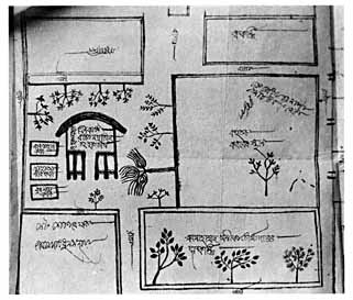
Fig. 22. Lohagara, Satkania Thana, thatched mosque established in 1720, diagram dated 1843. “Kanun Daimer Nathi,” Chittagong District Collectorate Record Room, bundle 29, case no. 1808.
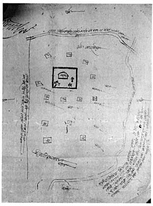
Fig. 23. Sundarpur, Fatikchhari Thana, thatched mosque established in 1759. “Kanun Daimer Nathi,” Chittagong District Collectorate Record Room, bundle 62, case no. 4005.
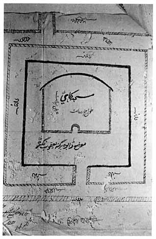
Fig. 24. Dabna, Hathazari Thana, thatched mosque established in 1766. “Kanun Daimer Nathi,” Chittagong District Collectorate Record Room, bundle 51, case no. 3329.
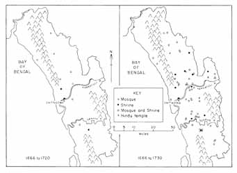
Map 6. Growth of the Muslim institutions in sarkār Chittagong, 1666–1760.
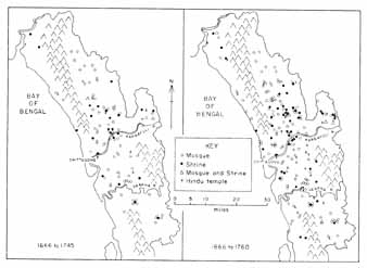
Map 6. (continued)
The social processes set in motion by these grants are seen in a sanad dated October 2, 1666, the earliest such document issued in Chittagong:
The economic aim of these grants, to expand the empire’s agrarian base, is evident from a phrase contained in nearly every sanad: “It is agreed that having brought the land into cultivation,” followed by a statement of the particular ways the recipient was expected to use the fruits of the land’s harvests.[39] The religious aim of grants for mosques and shrines was to promote Islamic piety in the countryside. In most cases this meant supporting simple, rural mosques and the petty functionaries and clerics who served them. For example, a 1721 sanad concerning the establishment of a mosque in Kadhurkhil, Boalkhali Thana, specified that in addition to expenses for carpets and lamps, the mosque’s tax-free lands were to be used to pay the reader of the sermon (khaṭīb), the prayer-leader (imām), the caller to prayer (mu’ażżin), pious men and preachers (muṣallīān), leaders in special prayers (fātiḥa ‘abdīn), and a sweeper (jārūb-kesh).[40] Other sanads made provisions for repairs (tarmīm) to the mosque, or mentioned special religious festivals earmarked for support, such as the major Muslim ‘Id holidays.[41] Still others supported Islamic ideals even when no institutional base was involved, as in the case of a grant of eight acres of jungle given in 1715 to Muhammad Munawwar and Shaikh Muhammad Ja‘far on condition that they read the Qur’an in Bakkhain, Patiya Thana.[42] Similarly, in 1748 Shaikh Imam Allah was granted 14.4 acres in Hulain, in the same thāna, for reading the Qur’an and performing prayers (fātiḥa).[43]Clerks [mutaṣaddī], assessors [mu‘āmil] past and present, headmen [chaudhurī], accountants [qānūngō], and peasants [ra‘āyā, muzāri‘] of the revenue circles [pargana] of Sarkar Islamabad [i.e., Chittagong], know that:
Shah Zain al-‘Abidin has made it known that he has many dependents and has built a mosque, where a great many faqīrs and inhabitants come and go. But, as he has no means of maintaining the mosque, he is hopeful that the Government will bestow some land on him.
Having investigated the matter, the revenue department has fixed the sum of six shāhī dūn and eight kānī [i.e., 166.4 acres] of jungle land, lying outside the revenue rolls, and located in villages Nayapara and others of pargana Havili Chittagong, as a charity for the expenses of the mosque as well as a charity for the person mentioned above. Once the land is brought under cultivation, the produce of the land must be used for the expenses of the mosque as well as the needs of himself, his descendants, and his dependents. And he must assiduously pray for the survival of the powerful state. He and his descendants are not required to pay any land revenue or non-land revenue, highway taxes, bridge taxes, special cesses, or any other assessments issuing from either the administrative or the revenue branches of government. Nor is he bound to seek a fresh sanad each year. Take great care to execute this order. Dated 2 Rabi I 1077.[38]
Politically, the grants aimed at deepening the roots of Mughal authority on the frontier. The condition that the grantee “must assiduously pray for the survival of the powerful state,” as in the 1666 sanad cited above, established a direct link between the government and the grantee, inaddition to an indirect link between the government and God. Not one document failed to mention this condition of government patronage. Less apparent, though no less important, was the state’s interest in securing the loyalty of those persons described as the grantee’s dependents (vā bastigān). These were people who, having assisted the grantee in clearing the forests and building the institution, continued to serve it by cultivating the lands attached to it, and were therefore its clients. Some documents explicitly stated that the purpose of the grant was to support the followers of this or that holy man, as in a 1725 grant to Taj al-Din and Zia al-Din, who received a patch of jungle in Hathazari Thana in order that its produce might support their children and “dependents.”[44] In 1745 three men—Mir Sa‘id Allah, Ghulam Husain, and Afzal Khalifa—declared that they had many dependents whom they could not support. For the maintenance of these persons, the state granted them 30.4 acres in the same thāna.[45] Other grants stated that after the expenses of maintaining the mosques or shrines had been met, the balance of the land’s produce should go to support the grantee’s dependents.[46] In sum, the government recognized mosques and shrines as the foci of sociopolitical activity on the frontier and sought to form them into a dependent clientele, just as those institutions had already formed dependent clienteles of their own.