INTERNATIONAL GEOPHYSICAL YEAR
On 5 April 1950 a dozen scientists conversed sociably on the unsolved mysteries of the earth at the home of James A. Van Allen in Silver Spring, Maryland. Floyd McCoy of Pitcairn Island, descendant of a Bounty mutineer, knew naught of their conversation then, but because of them he was working to help solve the earth's mysteries several years later. Also because of them, the palm trees on remote Clipperton Island were rearranged.
At the Van Allen home, Lloyd V. Berkner of the Carnegie Institution proposed an International Year for a frontal attack on the unknowns of the earth and its atmosphere, similar to the Polar Years of 1882 and 1932. The suggestion caught on, and so committees were formed, nations joined in, and on 1 July 1957 began the International Geophysical Year (IGY), which, with casual disregard for the calendar, was designated to continue until December 1958. The time was selected to coincide with the peak of the eleven-year sunspot cycle, with a concurrent eclipse, and as the silver anniversary of the second Polar Year. It was not, said Revelle, designated as “a year in which we should all be kind to geophysicists” — although, considering how much they had to do, perhaps we should have been.
The international committee that coordinated the IGY was the “Comité Special de l'Année Geophysique Internationale” (CSAGI). Most of the sixty-plus participating nations set up their own national committees; in the United States this was under the auspices of the National Academy of Sciences-National Research Council, and was chaired by Joseph Kaplan of UCLA. For the many scientific fields to be covered, separate panels were established, to consider proposals of special projects. In the United States these were managed through the National Science Foundation.
As the year opened, Kaplan defined its scope: “Scientists of the world are going to take a long and special look at our earth — at its wrinkled crust, its hot heart, its deep seas, its envelope of air, its mighty magnetism, its relationship to outer space.”[25]
So, during the IGY, rockets and satellites went up, probes and dredges went down. Meteorologists, physicists, astronomers, glaciologists, oceanographers — all had observations to make. Projects were established from the equator to the poles. The “year” began auspiciously two days early,
In and beneath the vast seas lay some of the answers to the riddles of the earth: How does water move throughout the ocean? How fast is the exchange of water from the Antarctic to the equator? Can the ocean contain radioactive wastes safely and harmlessly? How do the oceans affect weather? How great is the change in sea level throughout the world? What causes the long waves and storm surges that invade beaches from time to time? What is the shape of the sea floor? What lies beneath it? Hoping for answers to these questions, during the IGY 75 research ships plied the high seas; eight of them were American, and three of those, Scrippsian.
In addition, Scripps was in charge of an island observatory program, which established 16 stations throughout the Pacific Ocean to measure sea level fluctuations, ocean temperatures and salinities, and carbon dioxide in the atmosphere. William G. Van Dorn also set up equipment for measuring earthquake-caused tsunamis. Under coordinators Jeffery D. Frautschy and June G. Patullo, a call went out for personnel to man the island stations. For the station on Tahiti, “a veritable flood of applicants” came forth, said June Patullo, but with a smile she noted that “for some reason we are unable to understand, we have no volunteers for Jarvis.” For that bit of land, two miles long and one mile wide, 1,500 miles south of Hawaii, a volunteer was finally found: Otto Horning, a man who preferred solitude, and who had the mechanical ingenuity to keep the equipment operating. He had previously lived alone on equally lonely Palmyra Island. Horning died on Jarvis Island while in the service of the IGY, and his native assistant (whom Horning had recruited from another island) notified British authorities. Audley A. (“Al”) Allanson of Scripps and his wife completed the IGY observations on Jarvis.
The most important man to the survey [concluded June Patullo] was the individual observer. On Arorae, a small speck of British land just south of the Equator in the western Pacific, Neemia Matiota and his Gilbertese neighbors kept a tide gage working for more than two years. Five hundred miles to the west Captain Steve Dexter, with the assistance of the British Phosphate Commissioners, ran what is probably the best complete station of the Scripps-operated stations: Ocean Island, where both sea level and temperature and salinity observations were observed for more than two years. A couple of thousand miles southeast of these two, a French citizen of Tahitian-Polish ancestry, Malinowski by name, found time between his duties as weather observer, radio operator, and postmaster on Rurutu to take a good series of both kinds of data at that hilly green island. A young man working on Guam as Observer in Charge of the U.S. Coast Survey's geomagnetic station received a box of equipment from us and then wrote us a puzzled letter asking what to do with it. We explained to our embarrassment that our supposed arrangements had somehow gone awry; nevertheless Dave Newman [the young man] agreed to take the boat observations we requested and did a first-class job.[26]
In the Tuamotu Islands one time, the observers' boat sank a mile from shore, to which two of the three men (one American and one Polynesian) swam; they returned with an outrigger canoe to rescue their older companion, who had remained clinging to an equipment box. They radioed for replacement supplies and soon resumed work.
Drying plankton nets on Transpac Expedition, 1953.
Another figure in the island program was Martin Vitousek, who with his wife ran the supply boat from Fanning Island to the lonely outposts of Jarvis and Palmyra.
On Pitcairn Island, Floyd McCoy serviced a sea-level recorder, collected sea-water samples, and measured the vertical temperature structure of the water throughout the IGY and for a year beyond it. This fourth-generation descendant of one of the original Bounty mutineers was saving his earnings for a trip to the United States with his Australian-born wife. In 1960 the McCoys spent six months touring the United States, the first couple from Pitcairn to visit this country. Their final stop was at Scripps to visit with acquaintances made through the IGY.
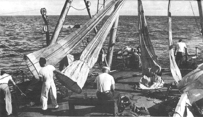
Downwind Expedition was the first of three that Scripps sent out as part of the IGY. From October 1957 to February 1958, the Horizon and the Spencer F. Baird logged 40,000 miles throughout the southeastern Pacific on a track laid out to take advantage of following winds and currents (hence “downwind”). H. William Menard was overall expedition leader for the first half of the cruise, and Robert L. Fisher for the second half. The emphasis was on geology, geophysics, and chemistry.
The ships worked together and separately, carrying out seismic-refraction profiles, hydrographic casts, coring, dredging, continuous echo-sounding, current measurements with the “jog log,” and collecting water samples for radio-isotope analysis, air samples for carbon dioxide content, plankton samples, bathythermograph readings, and ocean-floor temperature measurements. From their disadvantageous point far above the structure they sought, the
The East Pacific Rise was of particular interest to Menard. That a shallow area existed between Tahiti and Chile had been known since the Challenger crossed it in 1873. Alexander Agassiz also found shallower soundings on a reconnaissance aboard the Albatross in 1900, from which the name Albatross Plateau was derived. After 1946, soundings from U.S. Navy ships traveling to and from Antarctica helped define the great bulge in the southeastern Pacific Ocean. Downwind Expedition crisscrossed the area and found that the rise was indeed a major distinctive topographic feature: a curving bulge from near New Zealand to the coast of North America, 2,000 to 4,000 kilometers wide, 13,000 kilometers long, and two to three kilometers high (with a few isolated volcanoes rising higher). Along the crest of the rise the earth's crust proved to be unusually thin, and the rate of heat flow from the earth's interior was unusually high; shallow earthquakes were already known from the region. Seismic studies showed that the mantle bulged upward beneath the rise. Crossing the rise transversely were a number of straight lines of mountainous topography — fracture zones — characterized by islands and submarine volcanoes. Menard theorized that a youthful convection current in the mantle could explain the upward bulging of the mantle; this would force the crust to arch upward and would create a system of tension cracks, susceptible to wrench faulting, parallel to the rise.
Where the land met the sea, the Downwind wanderers explored the coral reefs of Fakarava Atoll; the social life of Tahiti; the coral growths of the channel into the harbor at Rapa Island; Alexander Selkirk's cave on the Juan Fernández Islands; the cuisine and viniculture of Antofagasta, Viña del Mar, and Santiago, Chile, and the pisco of Callao and Lima,
That lonely rock was rumored to be a great place to acquire lava carvings simply in exchange for worn clothing. But an unusual rush of visitors to Easter Island shortly before the Downwind ships reached it had sadly depleted the supply of carvings. However, cooperative islanders sat up all night carving the soft rock into distinctive faces (rather like the giant carvings for which the island is famed), which they exchanged for the old — and new — clothing of the visitors. Meanwhile, “in best tradition Scripps moonlight tiki sneaking society covered other side [of] island like locusts. Travelled on foot, by borrowed jeep and, groan, on horseback. Examined pictographs, statues, craters, made ethnological studies.”[27]
In Lima the oceanographers had discovered the whim of the public's interest in the ocean: reporters who met the two ships on 15 January expressed interest at first only in the hydrographic and biological aspects of the voyage, of keen interest to the country dependent upon fishing. The geologists took a back seat. But that afternoon an earthquake of magnitude 7 struck southern Peru and killed 28 persons in and near Arequipa. From that moment, said Fisher, “only geophysical and philosophical geology could get a line” from the representatives of the press.[28]
En route home the Downwinders on the Baird composed and recorded their odyssey in twenty-three verses and nine choruses, entitled “Downwind Calypso.” (There was very little demand for copies — perhaps because of such outrageous rhymings as seven with haven, discover with rubber, and overjoyed with employed? Original poetry composed at sea by oceanographers has a limited market.)
The second Scripps IGY expedition was Dolphin, led by John A. Knauss, from March to June 1958; its purpose
Knauss led the third IGY expedition also, from 1 August to 30 September 1958. The Horizon, the Spencer F. Baird, and the Stranger all sailed on that trip to explore the currents in the region of light winds near the equator — which gave the name Doldrums Expedition. The oceanographers returned puzzled at the ocean's circulation, for this expedition had discovered an unexpected large flow of water deep beneath the equatorial countercurrent.
Biologists took advantage of the available transportation to do some studies for several weeks on Clipperton Island, where they supplemented their ship stores with “fish, wild spinach, tern eggs, coconut meat, coconut apples, and coconut palm salad.” Conrad Limbaugh and the other divers studied shark behavior from what they called a shark cage, but which was really a diver cage, for the divers were inside taking notes on the sharks outside. They found the Navy's shark repellent to be at least 90 percent effective, they determined that the somewhat controversial fluorescent fabric for swimwear deterred sharks, and they observed that sharks find their prey chiefly by smell.
Entomologist Charles Harbison of the San Diego Museum of Natural History was in the Clipperton group and collected “so many insects that he would not even estimate the number.” The biologists together collected invertebrates, vertebrates, and plants until they estimated that Clipperton had become “the best collected island in the eastern Pacific.”[29]
Clipperton Island, “one of the loneliest, most isolated and smallest islands in the Pacific Ocean,” is the only coral island in the eastern Pacific. It lies 670 miles southwest of Acapulco, Mexico, and is distinguished by one 65-foot-high guano-covered pinnacle in its five square miles of coral sand
Scripps biologists contributed slightly to international misunderstanding in 1958. They accepted France's claim to the isolated bit of rock, and they accepted botanist and Frenchwoman Marie-Hélène Sachet of the U.S. Geological Survey (also on the staff of the National Academy of Sciences) as a member of the land party, although Scripps was not really accustomed to having women on expeditions then. Differences of opinion arose between Limbaugh and Miss Sachet, essentially over who was in charge of what: it was, after all, her island; he was, after all, scientific leader. But Limbaugh had the last word, for he and three others stayed two weeks beyond the others, and during that time, partly because bad weather prevented them from accomplishing much scientific work around the island, the cast-aways occupied their time by transplanting young sprouting coconuts to the northeast side of the atoll, neatly set out to form the letters “U C.”[*]
[*] I haven't been able to find anyone who has been to Clipperton since, to tell me whether the planting survived.