PLATFORMS AND VEHICLES
MPL's staff includes several people who, as Spiess said, “want to build something and take it out and run it.” Over the years they have produced an astonishing array of devices, under a collection of contrived acronyms — the kind of ocean-going gear that frequently draws puzzled queries from passing ships.
Flip is the most widely known: the Floating Instrument Platform. It is defined as a manned ocean buoy, and its purpose is to gain access to the relatively calm water below the wave-churned surface. This it does by standing on end, or flipping upright, in which position it exposes 55 feet above water and extends 300 feet below the surface. Upright it becomes a stable platform that moves up and down only a small fraction — about five percent — of the height of the passing waves. Designed originally, and successfully, for fine-scale studies of sound sources in the water, it has proved “more valuable to the Navy than when it was first launched.” Those who work from Flip appreciate her stability for their own sake.
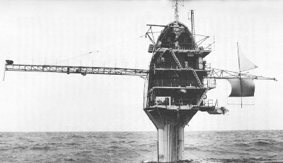
Flip, the floating instrument platform of the Marine Physical Laboratory, in its working position.
Submariners had long known of the advantages of working beneath the wave zone. But submarines are expensive research tools, and do not hold a set depth except under way. Allyn Vine at Woods Hole Oceanographic Institution once suggested standing a submarine on end for research studies. In the late 1950s war-experienced
The first trials (with some trepidations) took place in Dabob Bay in Puget Sound in late July of 1962. There the flipping on end and the return to horizontal were entirely successful, and so they have continued.
When being towed in the horizontal position, the craft is stabilized by concrete and steel ballast well below the horizontal center line. The transition to vertical is accomplished by filling ballast tanks with sea water, which takes about twenty minutes. Personnel on Flip always stay on the outside platform during a flip, for safety's sake, each with one foot braced on the deck, the other on the bulkhead, as the craft shifts. All permanent equipment is on trunnions so that everything can manipulate a 90-degree turn. Mistakes rarely happen, but once an unnoticed can of food became lodged under the galley range during a flip, which prevented that unit from turning, so, of course, the simmering stew was flung all over the neatly made bunks.
Flip has chiefly been used for studies of sound propagation in the water; she was designed, in fact, and used by Fred Fisher for studies of the “twinkle” of a sound source
ORB and RUM are a pair of MPL vehicles that often work as a team. The Remote Underwater Manipulator (RUM) was first intended to work alone, crawling about on the sea floor at depths down to 6,000 meters to gather objects and samples, to take photographs, and to install deep-sea instruments. Victor C. Anderson began assembling it in 1958, starting with a Marine Corps self-propelled rifle carrier; to this he added a boom and a steel claw that could be pivoted in any direction out to about five meters to pick up objects. The gasoline engine was replaced with a pair of heavy electric motors in an oil-filled compartment. Sonar was installed, and a powerful light and four television cameras for sea-floor surveillance from a portable shore station (actually a bus). Power for RUM and sensor signals were provided by way of a coaxial cable 8,000 meters long. Early tests in shallow water were only moderately successful, and RUM was set aside for other projects.
By December 1967, ORB (Ocean Research Buoy) had been developed as a platform for suspending equipment and particularly as a service vehicle for RUM. ORB is a barge 45 feet by 65 feet with a large center well through which the ten-ton RUM is operated by means of a constant-tension winch. It has two laboratories, a galley and messhall, and sleeping quarters for twelve people. “Loading RUM is a somewhat unconventional operation,” its designers wrote. “RUM is first lowered to the bottom of the bay by a crane. Then ORB is moved to a position over RUM, divers attach the strain cable, and RUM is lifted up through the well doors.”[24] Unconventional or not, it does work. RUM has been used for taking cores at depths down to 1,900 meters, for measurements of sediment properties in place, for underwater photography, for recovering equipment at depths down to 1,260 meters, and for sampling deep-sea biological communities. It has the advantage of being able to stay on the sea floor at work much longer than manned submersibles. On one of its earliest sea trials, in 1970, RUM placed two small sonar reflectors on the sea floor, crawled away from them, and returned to find and retrieve them. It also found a third sea-floor object:
… a can of a well-known brand of stewed tomatoes. … The can was found to be the dwelling of a small and very frightened octopus. We feel [said RUM's inventors] that this is one of the first times that a mobile biological specimen has been selectively retrieved by a remotely controlled manipulator as well as record of the first sea-going anti-pollution effort by such a unit.[25]
Anderson also developed the Benthic Laboratory, first used as a communications center for Sealab II in 1965 (see chapter 6). The laboratory housed electronic equipment
Another of MPL's novel contrivances is the Deep Tow (an attempt to name this FISH, for Fully Instrumented Submersible Housing, has not been entirely successful, although almost any slender object towed behind a ship is called a fish anyway). The Deep Tow is a mapping and navigation system in the form of a package of instruments that can be lowered and towed close to the sea floor to make detailed surveys. Development of such a unit began early in the 1960s, chiefly by Maurice S. McGehee and Dwight (“Tony”) E. Boegeman, Jr. The first design problem was in the motion of the towed unit, so a roll meter, a pitch meter, and a flow meter were developed. Upward-looking and downward-looking sonars were added, and these were followed by a variety of oceanic instruments.
In 1967 one of the units was lost in 3,000 meters of water when the tow wire parted. Its exact location was known, so “after quick development of some special equipment,” Spiess and others returned to the spot six months later and successfully retrieved their unit with the aid of a second one — no small feat in ocean navigation. A special
Surveys by Deep Tow have been made in trenches and canyons, over seamounts and fans, in the Pacific and in the Atlantic. The array of instruments can include precision navigation equipment, side-looking sonar, a low-frequency sound source for seismic studies, underwater cameras, television cameras, thermometers, and a magnetometer towed behind the “fish.” All these instruments can be put to work on command and be monitored from the towing ship by way of the coaxial tow cable. For precise navigation of the ship and the Deep Tow, acoustic transponders, which answer to sound pulses from the towed unit, are placed on the sea floor. The precision capability of the instrument package was well demonstrated in 1971, when it was able to pinpoint the wreckage of five munitions ships that had been pulverized during munitions disposal. Geologic features as small as ten meters across have been mapped.
As with many of MPL's devices, the Deep Tow has more than one application: its capability of fine-scale surveying makes it equally useful to geologic mapping and to locating objects, such as shipwrecks or patches of manganese nodules, on the ocean floor.