The Preservation and Restoration of Riparian Resources in Conducting Flood Control Activities[1]
William M. Lockard and Richard A. Burgess[2]
Abstract.—Flood control activities often require the modification of riparian resources in the interest of public safety. Such activities may do considerable damage to riparian systems. An important goal for those interested in riparian resource preservation is to work with flood control organizations so that necessary flood control activities may be completed in a more environmentally sensitive manner. This paper proposes a five-point program for the riparian resource manager which pursues that goal. The paper concludes that such a program, designed and operated at the local level, is a superior alternative to one generated by a state mandate.
Introduction
The riparian resource manager is confronted with many of the factors influencing streams and rivers. Where riparian systems are relatively pristine and isolated, the manager's primary goal is to preserve, to the extent possible, natural fluvial processes. More often, however, riparian systems are located within agricultural or urban areas. Normally, in these cases, the riparian system falls within the jurisdiction of a local flood control organization.
The first and foremost responsibility of flood control organizations has been, and continues to be, the protection of life and property. However, does such an organization also have a responsibility as a steward of riparian resources? Not long ago, the universal answer would have been no. However, the environmental movement and certain state mandates, such as the California Environmental Quality Act, have created an environment for change. While some flood control organizations already recognize their responsibility to riparian resources, others may be persuaded.
While a state mandate could be created which would force flood control organizations to preserve and restore riparian systems, this paper assumes that it is more desirable to instill a conservation ethic in flood control organizations.
We do not suggest that flood control organizations should subjugate their primary responsibilities relating to public safety. We suggest that needed flood control activities can be performed in ways which also preserve and restore riparian systems. This paper, then, presents a program for the riparian resource manager to use when working with flood control organizations. The program is based on the Ventura County experience and contains examples from ongoing programs. The program contains five basic elements as discussed below.
A Five-Point Riparian Resource Management Program
Establish Political Support
Although this program assumes that a state mandate is not the motivation for riparian resource management, there are other types of state assistance which might be considered appropriate support. These include grants-in-aid to develop the program, technical expertise, educational programs, guidelines and criteria, and the definition of sensitive riparian systems of significance.
However, the most important political support for the program should come from the local decision-making body. Flood control personnel are normally responsible to their board of directors or the county board of supervisors. Since a resource management program involves the expendi-
[1] Paper presented at the California Riparian Systems Conference. [University of California, Davis, September 17–19, 1981.]
[2] William M. Lockard is Staff Conservationist, and Richard A. Burgess is Conservationist; both are with Ventura County Flood Control District, Ventura, Calif.
ture of time and money, it must be sanctioned by the decision-making body. Furthermore, flood control personnel need assurances as to what their (new) role as resource manager is. Local political support is not sought as a lever to force the program on unwilling employees. For that reason, policy guidelines should come from the political body. Policy guidelines clarify making body's position and yet allow the manager flexibility.
For example, five important policies were adopted by the Ventura County Board of Supervisors as part of the county's Section 208 Areawide Water Quality Management Plan. These policies can be found in example 1.
Example l.—Policy guidelines adopted by the Ventura County Board of Supervisors
A. PUBLIC SAFETY AND WELFARE POLICY
The Board of Supervisors of the Ventura County Flood Control District is committed to responsible flood control activities. Nevertheless, the first and foremost responsibility of the Board of Supervisors, the County staff and all others involved in flood control activities is the protection of life and property. Therefore, it is the policy of the Ventura County Board of Supervisors that no action suggested in this manual shall be accomplished where such action would clearly constitute a threat to life, property or the public welfare.
B. COORDINATION POLICY
The Ventura County Flood Control District will seek, whenever possible, the expertise and advice of the California Department of Fish and Game where flood control activities might have an adverse effect on the County's streams and rivers. During emergency flood conditions, the Deputy Director of Public Works, Flood Control and Water Resources, or his designated representative will provide reports to the Department of Fish and Game and, in accordance with the [California] Fish and Game Code, arrange field meetings to discuss emergency flood control work.
The goal of this policy is to provide the concerned parties with a greater understanding of the physical and economic constraints of flood control activities and basic hydrologic and fluvial processes. It is also the purpose of this policy to cause better understanding of the biological requirements of riparian environments, as well as the ecological relationships of riparian and adjacent habitats. Further, this policy is intended to improve the Flood Control District's ability to perform necessary flood control activities in an environmentally responsible manner.
C. RESTORATION POLICY
It is inevitable that some flood control activities will adversely affect riparian resources in Ventura County. It is not always possible in such a narrow and sensitive habitat to avoid adverse effects with certain flood control activities. Such activities may be necessitated by emergency flood conditions or normal preventative maintenance. Where physical and economic conditions allow, the District may mitigate these effects by utilizing various restoration techniques after the flood control activity is completed. If flood control activities involving such restoration work are to take place in Ventura County, the following policy shall apply: Where physical and budgetary conditions permit, the Ventura County Flood Control District shall initiate restoration programs to mitigate alterations to sensitive or unique riparian resources which have occurred as a result of flood control activities. Such work shall be accomplished pursuant to the criteria defined in the "Operators Manual for Conducting Flood Control Activities in Ventura County Streams and Rivers, April, 1981" [Ventura County Public Works Agency, Flood Control and Water Resources Department 1981] and shall be coordinated with appropriate State and Federal agencies pursuant to the District's Coordination Policy.
D. BEST MANAGEMENT PRACTICES POLICY
It is the policy of the Board of Supervisors of the Ventura County Flood Control District to encourage the use of the Best Management Practices defined in the Operators Manual for Conducting Flood Control Activities in Ventura County Streams and Rivers, April, 1981" [ibid .]
The Best Management Practices herein adopted replace the "Policy Guidelines for Work Conducted in Streams and Rivers During Emergency Conditions" adopted by the Board of Supervisors on September 23, 1980.
Example 1.—Continued.
E. CONTRACTOR'S RESPONSIBILITIES POLICY
The policies and best management practices adopted by the Board of Supervisors as part of the Operator's Manual shall be referenced into any contracts or agreements between the County of Ventura or any of its agencies and any contractor or subcontractor retained by the County. Such contracts shall require that the contractor acknowledge familiarity with the provisions of the Operator's Manual and to assume responsibility for conducting any work performed under such contract in accordance with the policies and best management practices of the Operator's Manual.
The purpose of this policy is to put contractors on notice that it is the policy of the County of Ventura that County-sponsored flood control activities are to be conducted in a manner which protects riparian resources wherever possible.
The following is a hypothetical conversation between two people standing along a lush pristine stream in Ventura County. The first person is Jake, Field Supervisor for the County Flood Control District. The second person is Mike, Biology instructor at a nearby college and member of a local environmental group. A third party, astride a weathered D-8 bulldozer, waits nearby with his engine on an impatient idle.
Mike: What's going on?
Jake: We have to get these lousy bushes out of here!
Mike: Lousy bushes? This is one of the best streams in the county. Those are spawning beds right over there, and there might even be unarmored three-spined stickleback in this stream!
Jake: Unarmored what?
Mike: Unarmored three sp . . .
Jake interrupts with a disgusted look on his face and wave of his hand.
Jake: Aw, forget it. I have a job to do. We're here to protect people, not fish, and that bulldozer up there is costing the taxpayers money!
Jake looks at the bulldozer operator and points an index finger at the stream. The bulldozer moves quickly forward and begins removing the "lousy bushes."
After the bulldozer has done its work, it doesn't matter if Jake or Mike was right. This situation is relatively easy to imagine. It illustrates the damage that can result from poor communication. Effective communication is essential to a successful riparian management program, and it should be the responsibility of the manager to make it occur. Although we will not go into great detail in discussing the psychology of communication, there are a number of common-sense communication axioms that a resource manager should consider.
1. There is more to communication than the spoken word. Body movements, facial expressions, inflections in the voice, and even inactivity communicate a message (Watzlawick etal 1967).
2. The two basic components of communication are the content (the message) and the relationship (between communicants). A "healthy" communication is one in which the content of the communication predominates. Conversely, a "sick" conversation is characterized by a constant struggle about the nature of the relationship between communicants (ibid .).
3. The relationship component of a communication tends to dominate when an individual feels defensive. Individuals may feel defensive when verbal (or non-verbal) communication tends to suggest that: a) he is being evaluated or judged; b) there is an attempt to control him; c) there is a strategy or "game" going on; or d) the speaker appears uncaring, ungiving, or neutral to the individual's position (Gibb 1961).
The content aspect of communication tends to dominate when an individual feels less defensive and the conversation is more spontaneous and problem oriented. An individual is less defensive when he views the other communicant as an equal, as someone who empathizes with his position and/or wants to know what he has to say (ibid .).
Education Program Design
The orderly mesh of materials, content, and participants is an essential part of any successful program. A structured program design is not only common sense, it usually saves time and money and helps keep participants interested. The education program we suggest is discussed below, with examples provided by ongoing educational programs in Ventura County.
The Need for Dual Education
It is prudent to acknowledge from the beginning that an education program is not one-sided, with the resource manager in the role of teacher and flood control personnel in the role of stu-
dents. In truth, the resource manager may have a great deal to learn about the flood control organization and its activities. More importantly, the goal of the program—the preservation of riparian resources—will be primarily realized through dialogue in the field, as potential implementation tools are tested and evaluated. In this regard, everyone in the program is a student. In fact, the justification for the education program must be to provide a mutual frame of reference for field dialogue. We suggest that the following subjects should be covered in the education program to achieve that mutual frame of reference.
The Fluvial Process
"Fluvial" is defined in Webster's Dictionary (1971) as that which is "produced by stream action." The term may be unfamiliar to some involved in flood control activities. Other terms may come to mind for them such as "hydraulic" (that which is operated or moved by water) and "hydrologic" (dealing with the properties, distribution and circulation of water). However, these latter terms do not fully describe what is to be defined. The critical point is that streams and rivers are part of a process (defined in Webster's Dictionary as "a natural phenomenon marked by gradual changes that lead toward a particular result"). We suggest that "fluvial process" be defined as: A natural process which results from the dynamic interaction of the hydrologic cycle, the earth's geology, and the living environment.
Process implies movement. The energy sources of the fluvial process are often taken for granted and should be simply defined. These energy sources include gravity, solar energy, and geologic movement (uplifting) of the earth's crust. Other terms which should be defined relate to the with physical effects of these energy sources. These terms include precipitation, transportation, weathering, erosion, and deposition.
A deeper appreciation of fluvial processes comes with an understanding of geologic time and the history of local streams and rivers. Flood control personnel observe from experience that drainage basins differ. One is rugged and rocky, another is flat and sandy. One reason for this probably involves geologic formations. Soil maps of debris-producing soil formations which were once ancient oceans and are now high in elevation could be used to illustrate the forces and time frame involved in the formation of riparian systems. If possible, more recent deposits can be related to existing land features. Figure 1 was used in the "Technical Paper for the Ventura County 208 Water Quality Management Plan" (Lockard and Burgess 1981). The authors pointed out in this example how the Santa Clara River changed course in 1969 from point "b" back to point "a", resulting in considerable damage to the Ventura marina.
The physical elements of a stream or river, which are a result of the fluvial process, provide the medium for the biotic components of the system. The diversity of physical stream elements has permitted a high diversity of wildlife. Each element is part of an interdependent whole. This fact should be stressed as basic stream elements are identified and discussed. Physical stream elements which should be discussed in the education program include: 1) braiding and stream width; 2) pools and riffles; and 3) rapids and falls.
In discussing these elements, it may be convenient to use the description of a "textbook stream" presented in example 2.
Biological Resources and Ecology
A discussion of riparian biology and ecology can be incredibly fascinating or incredibly boring, depending on the presentation and the audience. Realistically, the resource manager should not expect rabid enthusiasm from flood control personnel when the subject of riparian biology is breached. A realistic goal is to keep the topic interesting. The resource manager is faced with the dilemma of deciding what kind and how much of this complex subject to present. It is suggested that this aspect of the education program be broken down into three categories.
1. What are biological resources?
2. How do biological resources interact with the environment (ecology)?
3. What affect do flood control activities have on biological resources?
Biological Resources .—In discussing biological resources of riparian systems, it is convenient to divide them into two areas, aquatic and riparian life. Aquatic is defined as that component of the biota which lives in or on the water. It should be pointed out that aquatic organisms have not only adapted to the medium of water, but also to its movement (see example 3). If local streams provide a significant sports fishery, it is often worth stressing this, since it is a utilitarian value to which people relate strongly (see example 4). Additionally, in discussing aquatic life, it is desirable to accentuate the diversity that exists there. Plants, microorganisms, algae, aquatic insects, reptiles, amphibians, and small aquatic mammals, such as muskrats, should all be discussed briefly.
The importance of the riparian environment as an interface between aquatic and terrestrial environments should be covered. A definition of the plant associations in riparian areas is desirable (fig. 2). A discussion of the diversity of plants and wildlife of riparian systems is most important. The terrestrial wildlife species which use riparian systems for food and cover should also be discussed (example 5).
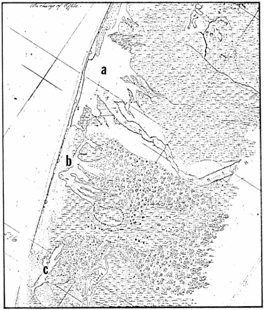
Figure 1.
1855 U.S. Coastal Survey map. Significant points: a) Santa Clara River mouth and
approximate location of present Ventura Marina; b) approximate location of existing
Santa Clara River mouth; c) estuary and present location of McGrath Lake.
Example 2.—The textbook stream.
The "textbook" stream begins in the highest points of the drainage basin as surface runoff or groundwater forming small, fast-moving brooks. Precipitation is greater here than low lying areas, and weathering tends to be greater. These first brooks are characterized by relatively cold, clear, fast-moving water. The overall stream gradient is very steep. The stream tends to be quite erosive, but little deposition occurs. The streambottom is irregular and primarily composed of large rounded rocks which have been shaped by the turbulent, forceful movement of water. The turbulence tends to increase the level of dissolved oxygen in the water.
Example 2.—Continued.
As the brook moves downstream, it joins with other tributaries. The overall stream gradient becomes less steep, but the water continues to be fast-moving and turbulent. Both erosion and deposition are evident. The streambottom begins to be composed of small rocks, pebbles, and sand. The water is not quite as clear and contains some silt and clay particles in suspension.
As the stream moves out of the mountainous and hilly areas into the coastal plain, the gradient decreases even more. The streambottom is smoother and composed of sand, silt, and clay deposits. The volume of water is quite high, but the water moves much slower and with little turbulence. Deposition is much greater, and stream meander and braiding is more pronounced. Precipitation is much lower than in the mountain areas. Bank erosion is reduced considerably.
The "textbook" stream ends as the stream drains into the ocean. The stream may either form an embayment here or flow directly into the ocean. Gradients are very shallow, and deposition is at its greatest. The water often has low levels of dissolved oxygen and high levels of organic matter. There is usually a daily mix of salt water and fresh water (Clapham 1973).
Example 3.—Invertebrate adaption to water movement in streams.
The most conspicuous invertebrates in such situations are frequently aquatic insects which occur as immature forms as well as adults. Insects have been very successful in adapting to aquatic freshwater habitats and may be quite numerous. For example, in a study of a California stream, a single riffle area was found to be inhabited by almost 40 different species of insects (Reid 1961). Insects which live in rapidly moving water tend to be strongly modified so that they are not washed away by the current. They may be firmly attached to rocks, such as black fly larvae (Simulium sp.), or greatly streamlined, such as the naiads of some types of dragonflies (Order Odonata), mayflies (Order Ephemeroptera), and stoneflies (Order Plecoptera). Other insects solve the problem of current by living under or behind objects where the force of water is reduced. The larvae of dobsonflies (Family Corydalidae), caddisflies (Order Trichoptera), as well as a number of mayflies (Order Ephemeroptera) are characteristically found in such protected locations.
Example 4.—Requirements of fisheries.
Many of the streams in Ventura County still support a viable sport fishery. Although game species such as bluegill (Lepomismacrochirus ), green sunfish (L . cyanellus ), and large mouth bass (Micropterussalmoides ) have been introduced and are found with some regularity in county streams, they are more characteristic of lakes. By far the most important game fish in the streams and rivers of Ventura County is the rainbow trout (Salmogairdneri ) and its oceangoing relative, the steelhead rainbow trout (S . g . gairdneri ). Both of these fish are native to the county; however, populations of rainbow trout are supplemented with hatchery fish by the California Department of Fish and Game.
Rainbow trout require cool, clear, well-aerated water and are thus found in the larger, less-disturbed watercourses. Depending on the water conditions, trout in Ventura County generally begin spawning in late February (Moore 1979). The female builds a nest in clean gravel where she lays from 200 to 21,000 eggs. These are fertilized by the male, lightly covered with gravel, and abandoned. The young fish begin emerging from the spawning beds in about three weeks and usually reach catchable size within two years (Palmer and Fowler 1975).
Example 4.—Continued.
The steelhead rainbow trout has essentially the same spawning requirements as the rainbow trout, but differs in that it is anadromous. Anadromous fish are those which spend a portion of their life cycle in marine water but must enter fresh water to spawn. Probably because conditions for growth are optimum in the sea, steelhead trout attain a much larger size than do their non-migratory relatives.
Figure 2.
A definition of plant associations in riparian areas.
Example 5.—Wildlife which use riparian areas.
In addition to providing food and habitat for endemic animals, riparian woodlands are also important to more wide-ranging species. In Ventura County, which experiences a long dry season, water can be a limiting factor to wildlife. The dense riparian plant growth provides cover for animals such as mule deer (Odocoileushemionuscalifornicus ), which may spend most of their time elsewhere, but come to streams to drink. Riparian woodlands also serve as important migration routes for many species of animals, providing corridors with readily available food, water, and cover (Odum 1978).
Riparian Ecology .—The education program should discuss riparian ecology as a subject separate from that of biological resources so that the interdependence of aquatic, riparian, and terrestrial systems can be better understood. In addition to a general discussion of ecology, presenting the concept of energy exchange is useful. Figures 3 and 4 could be used to illustrate the concept of energy exchange.
Effects of Flood Control Activities .—We suggest that flood control organizations be given the stewardship responsibility for preserving and restoring riparian resources. A legitimate step in accomplishing that goal is to make those involved in flood control activities more fully aware of the effects of their actions. This is based on the premise that with understanding goes responsibility.
Figure 3.
General diagram of an energy system.
Figure 4.
A highly simplified, generalized food web. The numbers next to the arrows indicate
the trophic level of the consumer. For example, a wading bird eating a fish would
function as a third-order consumer, while the same bird eating an aquatic insect
would be a second-order consumer. It should be noted that organisms rarely
feed consistently at one trophic level. Indeed, omnivores such as the raccoon
may feed at all levels, utilizing a variety of plant and animal matter.
It is useful to first discuss the potential (hypothetical) effects of flood control activities. The most obvious effect of flood control activities is the confinement of the natural floodplain. Associated with this are a decrease in river meandering, reduced deposition of soils and nutrients, and the separation of riparian systems from each other and from the stream. Other potential effects are disruption of natural stream elements and disruption of stream biology and ecology. Example 6 presents a discussion of the effects of induced turbidity and sedimentation on fish populations.
Discussions of environmental effects based on past actions of the flood control organization may be an effective educational tool, but pose a threat to friendly open communication. This subject should be presented discreetly, and with a minimum of personal judgment. As the program progresses, flood control personnel should have a greater role in evaluating local projects and their effects. An example of a 1978 emergency project which weas evaluated during the preparation of the County's 208 Water Quality Management Plan is contained in example 7.
Example 6.—Effects of turbidity on fish population.
During storm periods, water velocities are usually sufficient to keep sediment in suspension (Shaw and Maga 1943). However, when instream flood control activities take place during periods when the water flow is insufficient to carry the sediment in suspension, the sediments settle out and, in addition to reducing invertebrate populations, cover fish eggs and spawning sites, as well as preventing the emergence of recently hatched young (Cordone and Kelley 1961). Moore found that instream flood control work in the Ventura River and San Antonio Creek, in the spring of 1978, produced heavy sedimentation during the months when juvenile fish were emerging and resulted in depressed numbers of salmonids in subsequent sampling periods (Moore 1980).
Example 7.—Evaluation of the effects of a flood control project.
The diversity and richness of life in riparian systems is well documented throughout the world. They do not, of course, exist in isolation, but are part of the larger natural ecosystem. The "edge" between riparian systems and terrestrial systems becomes extremely important. Therefore, the confinement of natural floodplains, partially through flood control activities, allows the development of urban and agricultural uses immediately adjacent to streams and rivers. This has, in Ventura County, resulted in the separation of riparian vegetation from natural riparian areas and from terrestrial systems. The consequences are: a) loss or reduction of plant and wildlife species which have specifically adapted to the "edge" between riparian and terrestrial systems; b) blocking and loss of vegetative cover used by terrestrial wildlife in migrating to riparian areas for food and water; c) degradation of water quality where rising groundwater is trapped and isolated from the natural stream; and d) isolation of riparian areas from periodic flooding and the related supply of water and nutrients required for riparian plants. Without sufficient water and nutrients, riparian plant communities eventually are replaced by less biologically productive terrestrial vegetation (fig. 5).
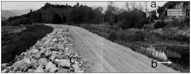
Figure 5.
Separation of riparian areas: a) Highway 33; b) isolated area with ponding
water and cattails; c) levee built in 1978 in the Ventura River just downstream
of its confluence with San Antonio Creek. (Photograph taken in March, 1981).
Flood Control Activities and Equipment
The resource manager must become a student as well. He needs to understand certain basics of flood control activities before meaningful dialogue is possible. These basics include the fundamentals of flood control engineering, watershed management techniques, flood control structures, and maintenance equipment and operations. A grasp of flood control terminology will greatly assist the resource manager in achieving "healthy" communication. Finally, the resource manager will find it highly useful to understand the realities of the fiscal constraints under which the flood control organization operates.
The fundamentals of flood control engineering are primarily related to the principles of hydraulics, since the function of flood control operations is to contain floodwaters. Some important hydraulic principles that should be understood are presented below.
1. The quantity of water ("Q") passing any given point is a function of channel gradient and cross-sectional area and water velocity, and is usually expressed in cubic feet per second (cfs).
2. The ability of water to hold debris (rock, sand, silt, clay and organic materials) in suspension is primarily a function of channel gradient and water velocity. Therefore, water that is carrying near its capacity of suspended solids is less able to erode than water carrying less than its capacity.
3. Surface runoff and the consequent volume of floodflows is a function of the permeability of the land surface. Vegetated land dissipates the energy of rainfall and absorbs water in the soil and plants. Urban areas have a much greater proportion of impervious surfaces (paved surfaces and roofs) and generate a proportionally greater runoff. In fact, areas that are over 80% urban may generate twice the floodflow of a corresponding natural area (Waananen etal . 1977).
4. Water velocity is a function of gradient and the surface resistance of the channel bottom and banks. Rougher, rockier bottoms and sides tend to reduce velocities, while smoother surfaces (such as concrete) increase velocities.
Watershed management involves flood control activities which attempt to reduce runoff and erosion. These practices include revegetating bare soil and encouraging deep-rooted plants. It may also include fuel modification programs which help avoid excessive runoff, which commonly occurs after a large, uncontrollable fire. Most importantly, watershed management should provide for the acquisition of floodplains and their exclusion from agricultural and urban conversion.
Flood control structures range from relatively simple and unobtrusive facilities to those that completely control and subjugate natural processes. Some flood control dams are meant to permanently hold floodflows (reservoirs) or to hold flows temporarily (retention basins), so that peak discharges can be held and released over longer periods of time (fig. 6). Other dams (debris basins) are constructed primarily to reduce the velocity of flows and encourage the deposition of suspended solids behind the dam. This allows "cleaner" water to pass through the dam. While this decreases the deposition of material downstream, it leaves the cleaner water with greater potential energy for erosion. Often, in these cases, energy dissipation or drop structures are placed downstream.
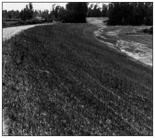
Figure 6.
Flood retention dam, Sycamore Canyon
Dam, Simi Valley, California.
Flood control structures which mainly confine the channel (usually called channel improvements) include levees, pilot channels, new earthen channels, trapezoidal channels with rock sideslopes, open concrete channels and concrete conduits (fig. 7).
The resource manager should become familiar with the equipment used in flood control activities. Each type of equipment has a purpose and a unique impact on riparian systems (fig. 8). Flood control maintenance operations often use this equipment to remove earth so that adequate channel capacity is maintained. This is more necessary where the channel is confined by urban or agricultural uses. However, riparian vegetation may also seriously reduce channel capacity by consuming cross-sectional volume and decreasing flow velocities. For this reason, flood control maintenance activities often involve the removal of riparian vegetation.
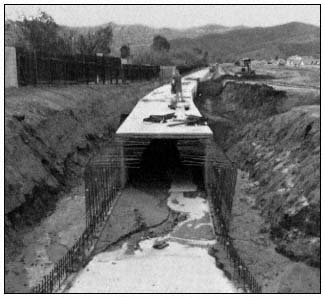
Figure 7.
Reinforced concrete box conduit under construction,
Santa Susana West Drain, Simi Valley. California, 1974.
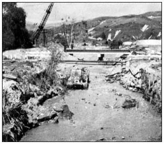
Figure 8.
Bulldozer and crane clearing debris after January,
1969 flood, Pole Creek, Fillmore, California.
Finally, the resource manager's education is not complete without some insight into the fiscal structure of the flood control organization. Any riparian resource management program will cost money to design and initiate. In the field, some of the best management practices may be more expensive to implement. Additionally, monitoring the program will require time and money. The resource manager should be prepared to answer inevitable questions about the costs of the program and how they relate to the total fiscal structure of the flood control organization. Unfortunately, he may find himself trying to balance the tangible fiscal costs of the program against the more intangible benefits of riparian resource preservation and restoration.
Define Environmentally Sensitive Management Practices
As already implied, those in flood control activities are, whether they know it or not, involved in riparian resource management. Structural projects, flood control maintenance, and monitoring of private development all require actions which affect riparian resources. The goal of the resource management program is to guide these activities in a more environmentally sensitive direction. The program should, therefore, provide direction to implement new "environmentally sensitive" management practices. Such practices will relate to the organization's own activities as well as those private sector activities over which it has authority.
Best Management Practices
The management practices suggested here are carefully thought out "clay pigeons." They were created out of the experiences and knowledge of the program participants. We expect them to change as their results are monitored and analyzed. The flood control personnel will evaluate the practices' effects on channel hydraulics and capacity, and the potential threat to life or property. The resource manager will evaluate the practices' effects on physical stream elements, biological productivity, etc. All participants in the program will collectively weigh the monetary and environmental cost:benefit relationships of the practices.
Environmentally sensitive mangement practices exerpted from the Ventura County's 208 Water Quality Management Plan, (approved in 1981), are presented in example 8. Most have not yet been applied in the field, so evaluation is difficult. Each is denoted as a best management practice (BMP) and numbered.
Annual Development Plan
The best management practices in example 8 are oriented toward the activities carried out by the flood control organization itself. However, there are similar activities carried out by the private sector over which the flood control organization often has some control. The most common of these private-sector activities is sand and gravel mining. In Ventura County, sand and gravel mining operations are required to obtain a watercourse permit to operate in any channel within the jurisdiction of the Ventura County Flood Control District. The primary purpose of this permit is to ensure that mining operations are not carried out in a manner which would create a potential flood danger.
Example 8.—Best management practices adopted by the Ventura County Board of Supervisors.
BMP-1. Keep work in streams to an absolute minimum.
Description: Doing the minimum work necessary is, in most cases, something that results from budgetary constraints and good sense. It is, however, the most environmentally sound management practice that can be pursued and is, therefore, worthy of comment here.
Why needed: Streams are the result of millions of years of evolution. Man, however, has the capability of applying great amounts of energy (via earth-moving equipment) in a sudden manner and otherwise disrupting the ecological balance resulting from that evolutionary process.
No amount of money or human effort can result in an exact duplication of nature. Given a million years, certain riparian species may adapt to or even be dependent upon the changes man is able to make through flood control activities. Now, however, the best we can hope to do, even with good management practices, is to assist nature in restoring damaged portions of the ecosystems. Therefore, the best management practice is to disturb this unique, important environmental resource as little as possible.
BMP-2. Where flood control activities are necessary, maintain a portion of the stream in its natural condition and isolate it from the required work.
Description: There are a number of ways in which this management practice can be achieved. Where work must be done in an area where one main channel exists, it may be possible to leave one side of the channel intact. It may be possible to selectively leave portions of the stream vegetation on both sides. In either case, it is essential to maintain the main stream flow adjacent to or through those riparian areas left intact.
Where it is necessary to work in a riparian area that contains more than one channel, it is desirable to leave at least one channel intact with a "buffer zone" of riparian vegetation of at least 50 feet on each side of the flowing water. This normally requires the insertion of a "soft plug" at the upstream terminus of the channels. The "soft plug" should be engineered to maintain low flows in the channel left intact, but allow larger storm flows to wash out the plug.
When there exists a choice of preserving one of several channels, the most environmentally sound choice involves consideration of several factors. These factors include: Proximity to other terrestrial habitats, time of year, existence of unique aquatic resources such as pools, riffle and spawning beds, etc. It is desirable to seek the advice of qualified experts in considering these factors, such as the California Department of Fish and Game and the USDI Fish and Wildlife Service.
Why needed: This management practice will be, in many cases, the fastest, most economical and most environmentally sound technique for preserving riparian resources. Except for the diversion of flows, it does little to the area left intact. During dry periods or when natural flows are being diverted upstream, it may be an "aquatic plus" by concentrating low flows into one channel. If the same low flow channel is used over a period of several years, it allows for the growth of mature riparian plant communities.
BMP-3. Where the earth must be physically moved, store the top two to three feet of material and redistribute after the work is completed.
Description: This practice involves the skimming off of observable nutrient-laden soils, stockpiling them and then redistributing them over finished work areas. This is a desirable practice, particularly near new stream channels. It is extremely important, however, that stockpiled material not be pushed into flowing water. This practice should be employed in rocky sandy stream areas where nutrients (in clay and silts) are scarce. This practice need not be utilized where stream gradients and adjacent soil profiles provide a rich abundance of soil nutrients.
Example 8.—Continued.
Why needed: One of the most basic characteristics of streams and rivers is that they carry materials from upstream areas and deposit them in downstream areas. Some of these materials are nutrients essential to aquatic and terrestrial species along streams and rivers. As flood flows decrease, these nutrients deposit along the receding stream along with native plant seeds and soil dwelling organisms. Since many of the desirable elements do not remain for long, the riparian plant community has adapted by being extremely fast growing and hardy. Nevertheless, even the riparian plants cannot grow well (or at all) without essential nutrients. Unfortunately, many control practices remove or bury nutrient-laden soils. They also remove them from their essential close proximity to the flowing water. This not only results in the reduction (or absence) of riparian plant species, but also promotes higher water temperatures (from less shade), less dissolved oxygen, less wildlife cover, etc.
BMP-4. Where earth work is required, restore natural features such as meanders, pools, turbulence and braiding.
Description: The primary aim of this management practice is not to replace visual aesthetics (although that is a legitimate goal). Rather, the purpose is to assist nature in bringing the disturbed riparian environment back to its desired ecological balance. The manner in which these natural features are restored depends on the previous "natural" circumstances. In a large river system such as the Santa Clara system, it may be appropriate to cut new channels, encourage meander and build pool areas with heavy equipment. In a smaller system such as the Ventura system, it may be appropriate in some areas to create small falls and pools by hand.
In utilizing this management practice, there are no pre-set plans which can be applied to a specific situation. Each stream area will likely have a unique combination of stream elements. A degree of subjective judgment must be used in deciding how to restore natural stream elements. While there is not necessarily a "right" solution, there are "better" solutions. Obviously, the "better" solution is going to result from careful evaluation of the natural stream elements and knowledge of the probable consequences of flood control work. In most situations, the evaluation should be done in the field with input from a qualified maintenance supervisor and a qualified biologist. The primary factors to be covered in the evaluation are found in "Work Sheet for Field Evaluations" [example 9].
Once this evaluation is made, initial decisions can be made as to which natural features are to be restored. Some decisions must be made as work progresses and will require a degree of creativity on the part of the maintenance supervisor. Even though each situation will be unique, there are certain benchmark criteria which can be useful in making field decisions. These "benchmarks" are defined below.
Benchmark Criteria for Restoring Natural Stream Features.
1. Place a 1 to 2-ft. fall at approximately 1/8 mile intervals.
2. Creation of depressions for ponds should be in a ratio of approximately 3:1 with the adjacent stream (i.e., a 3-ft. wide pool would be in proportion to a 1-ft. wide stream).
3. Construct potential stream channels that will meander, rather than flow in a straight line where work exceeds 1/8 mile in length.
4. In all areas except ponds, leave bottoms rough and irregular rather than smooth.
5. Use existing elements, such as large rocks over 4-ft. in diameter and existing falls as much as possible.
6. Use hand methods in creating smaller falls, pools and braiding.
Why needed: The natural features of a stream can be best described as nature's most efficient and diversified molding of the physical environment. The biological environment has evolved to take maximum advantage of these natural features in an evolutionary process which has taken millions of years. Unfortunately man, through flood control activities, has the capacity to disrupt these natural features and therefore place stress on the biological environment. However, some of these features can be replaced or at least assisted back.
Example 8.—Continued.
BMP-5. Install culverts, silt curtains and other devices that control turbidity where work must be conducted in or adjacent to stream water.
The effects of turbidity on aquatic ecosystems have been discussed. The previous discussion of other best management practices has stressed the need to avoid work in flowing water unless absolutely necessary. If flood control activities are necessary in stream waters, there are a number of ways in which habitat destruction and stream turbidity can be minimized. The following general criteria should be used in applying this management technique.
1. Where equipment must cross flowing water on more than one occasion, install a pipe culvert of sufficient capacity to handle existing flows. The pipe invert should be at or slightly below the existing stream bottom at both ends. Use clean sand and rock to cover the pipe and avoid the use of silts and clays.
2. Where equipment must work adjacent to a stream or pond, establish a barrier to keep equipment and soil from getting in the water. The best barrier is distance and no barrier is necessary if work is in excess of 20-ft. from the edge of water. The next best barrier is native vegetation and no additional barrier is needed if a 20-ft. wide strip of vegetation greater than 6-ft. high remains between the water and the work.
Where work must be conducted closer than 20-ft., a temporary barrier of large rock and sand 2- to 4-ft. high can be constructed. In unique circumstances, a temporary barrier of wood or metal may be used.
3. Where work must be conducted directly in water and flows cannot be diverted, the work should be completed as quickly as possible. In larger water bodies, and where flow velocities permit, plastic silt curtains should be placed down from the work. In faster flowing water, a series of small falls (2- to 3-ft.) can be constructed of larger rock to slow water and encourage the deposition of silts and clays.
Why needed: The primary purpose of this management practice is to avoid the direct and indirect destruction of aquatic systems. Direct effects include the removal of natural stream elements such as pools, falls, rapids, spawning beds, etc. Indirect effects include the disruption of key elements of the overall riparian system and the creation of turbidity which is carried downstream. Increased downstream turbidity may cover spawning beds and benthic (bottom) organisms. It may reduce total dissolved oxygen in the water and otherwise place additional stress on fish, aquatic plants and other aquatic organisms. Finally, turbidity can affect aquatic systems for many miles downstream of the occurrence.
Past experience with watercourse permits indicated that the conditions defined in some permits were not always consistent with those defined in permits required by other agencies. Specifically, it was found that the conditions of the watercourse permit and the Stream Alteration Agreement required by the California Fish and Game Code were sometimes at odds. Therefore, in the interest of better cooperation and resource management, the Ventura County Flood Control District initiated the Annual Development Plan (ADP) process in 1978. A typical annual development plan is developed according to the general schedule defined below.
1. Early spring—The sand and gravel company obtains aerial photographs and topography maps of the proposed excavation site after the winter rains are over.
2. April—The company submits a proposed ADP which includes the aerial photographs, topography and proposed vertical and horizontal extent of excavation for the coming year.
3. May—Meetings are held with the applicant, flood control district engineers, and representatives of the California Department of Fish and Game (DFG). The purpose of these meetings is to identify the concerns of each party and to reach agreement on a plan.
4. May to June—Once a compromise agreement is reached, the ADP is finalized. The final ADP consists of: a) an aerial photograph with horizontal elements identified (for example, see figure 9); b) topography maps, cross sections and profiles defining vertical elements; c) the watercourse permit for the year; d) the DFG permit.
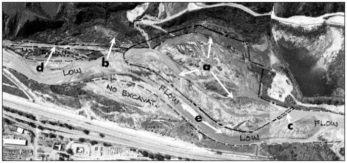
Figure 9.
Aerial photograph indicating typical items agreed upon for an Annual Development Plan: a) area of potential excavation;
b) wildlife corridor from mountainous area to top of photo; c) soft plug; d) haul road; e) low-flow corridor.
The Annual Development Plan process has proven to be reasonably successful in preserving riparian resources. All ADPs issued thus far have preserved a riparian corridor through excavation areas. A minimum buffer zone of 12–15 m. (40–50 ft.) on either side of the "low-flow" stream (fig. 9) has been maintained. Wildlife migration corridors have been identifed and reserved. Culverts are required at all stream crossings to protect the aquatic environment from turbidity. Finally, there has been an effort to create and maintain permanent low-flow areas and preserve significant mature riparian areas.
Implement and Monitor the Program
Implementation of the best management practices marks the true beginning of the riparian resource management program. Political commitment, a healthy communication environment, and a successful education program mean little without measurable physical improvement in riparian resources. Therefore, in order to evaluate the continued relative value of the program, monitoring activities are suggested. Areas of the program which should be monitored are discussed below.
Policy Guidelines
As the resource program progresses, it should be evaluated periodically for consistency with the adopted policy guidelines of the local decision-making body. Lessons learned in the field may suggest new management practices. Flood control personnel and the resource manager may find it prudent to recommend new policies commensurate with the new management practices. In any case, the decision-making body should receive annual reports from the staff in order to evaluate for themselves the consequences of their policy.
Education Program
The education program is an ongoing tool which allows the participants to make intelligent decisions about the best management practices and other field tools. The content of the education program should be periodically reviewed by the participants to see if it fits their level of expertise. New personnel will need to be made familiar with the background and the goals of the program.
Best Management Practices
As discussed earlier, the best management practices listed in example 8 are meant to change as field experience dictates. The monitoring of the best management practices should be systematically recorded. Photographs should be taken at least four times a year to record any changes in the managed area. Both ground-level and aerial photographs are desirable. The flood control personnel may also wish to monitor changes in stream elevations. This type of information is usually obtained from stereo-aerial photographs.
Evaluation of the best management practices should also be recorded in writing. For this pur-
Example 9.—Work sheet for field evaluations.
I. PHYSICAL FEATURES
A. Name of channel __________________________________________________________
B. Flood Zone ______________ C. Location _____________________________________
_______________________________________________________________________
D. Stream width ___________________ E. Approximate flow _________________________
F. Braiding? ____________________ How many? _________________________________
G. Type of bottom: Rocky Gravels Sand
Silt
H. Water clarity: Clear Turbid
I. Visual appearance of stream (attach pictures if taken)
_________________________________________________________________________
_________________________________________________________________________
II. BIOLOGICAL FEATURES
A. Dominant riparian vegetation: Willow Mule Fat
Giant Cain Sycamore Alder
Cottonwood Other _________________
B. Aquatic vegetation: Tules Cattails
Watercress Algae Pond Weed
Other _______________
C Wildlife observed:
1. Invertebrates ___________________________________________________________
2. Mammals ______________________________________________________________
3. Birds __________________________________________________________________
4. Fish ___________________________________________________________________
D. Apparent biological productivity of area __________________________________________
_________________________________________________________________________
———————————————————————————————————————————
pose, a "Worksheet for Field Evaluations" was created for the Ventura County 208 Water Quality Management Plan and is shown in example 9. The back of the worksheet provides space for a graphic plan of action and for biological and maintenance comments.
Conclusion
Flood control operations have a significant and often severe impact on riparian resources in California. The traditional approach of flood control organizations is to consider public safety as its only function. However, with local political support, improved communication, education, and better management practices, it is possible to assist flood control oganizations in accepting responsibility for the stewardship of riparian resources.
This concept may not be acceptable to some, particularly those more accustomed to bureaucratic combat with flood control organizations. Nevertheless, such a program has been initiated in Ventura County and appears to offer considerable promise. It is suggested that local organizations should be given the responsibility for riparian resource management rather than being burdened by yet another state mandate.
Literature Cited
Clapham, W.B., Jr. 1973. Natural ecosystems. 248 p. Macmillan Company. New York, N.Y.
Cordone, E., and D.W. Kelley. 1961. The influence of inorganic sediments on the aquatic life of streams. Calif. Fish and Game 47(2).
Gibb, J.R. 1973. Defensive communication. p. 284–291. In : C. D. Mortensen. Basic readings in communication theory. 358 p. Harper and Row, New York, N.Y.
Lockard, W.M., and R.A. Burgess. 1981. Technical paper for conducting flood control activities in Ventura County. 71 p. Ventura County Public Works Agency, Flood Control and Water Resources Department, Ventura, Calif.
Moore, M.R. 1979. Stream survey: Ojai Ranger District, Los Padres National Forest. 29+ p. USDA Forest Service.
Moore, M.R. 1980. Factors influencing the survival of juvenile steelhead rainbow trout (Salmo gairdneri gairdneri ) in the Ventura River, California. 82 p. M.S. Thesis, Humboldt State University, Arcata, Calif.
Odum, E.P. 1978. Ecological importance of the riparian zone. p. 2–4. In R.R. Johnson and J.F. McCormick (tech. coord.). Strategies for protection and management of floodplain wetlands and other riparian ecosystems: Proceedings of the symposium. [Callaway Gardens, Georgia, December 11–13, 1978.] USDA Forest Service GTR-WO-12, Washington, D.C. 410 p.
Palmer, E.L. 1975. Fieldbook of natural history. Second edition (revised by H.S. Fowler). 779 p. McGraw-Hill Book Company, New York, N.Y.
Reid, G.K. 1961. Ecology of inland waters and estuaries. 375 p. D. Van Nostrand Co., New York, N.Y.
Shaw, P.A., and J.A. Maga. 1943. The effect of mining silt on yield of fry from salmon spawning beds. Calif. Fish and Game 29(1): 29–41.
Ventura County Public Works Agency, Flood Control and Water Resources Department. 1981. Operator's manual for conducting flood control activities in Ventura County streams and rivers. 21 p. Ventura County Flood Control and Water Resources Department, Ventura, Calif.
Waananen, A.O., J.T. Limerinos, and W.J. Kockelman, etal . 1977. Flood-prone areas and land-use planning—selected examples from the San Francisco Bay Region, California. Geological Survey Professional Paper 942. 75 p. U.S. Government Printing Office, Washington, D.C.
Watzlawick, P., J.H. Beavin, and D.D. Jackson. 1967. Pragmatics of human communication. 296 p. W.W. Norton and Company, New York, N.Y.
Webster's Seventh New Collegiate Dictionary. 1971. 1,222 p. G. and C. Merriam Company, Springfield, Mass.