Early Sherpa Impact on Forests
The uncertainty about the extent of forest cover in Khumbu at the time of the first Sherpas' arrival there and the lack of oral traditions about forest use during the early centuries of Sherpa settlement make it impos-
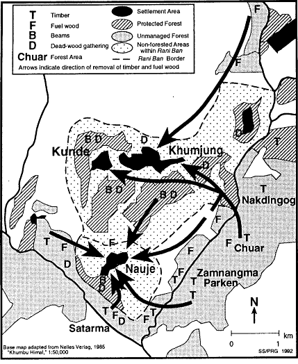
Map 18
Village Forest Use Patterns, 1915-1976
sible to evaluate fully the scope of Sherpa impact on forests over the past four centuries. Oral traditions and oral history, however, do make it possible to say something of the scale and processes of forest change during the last hundred to hundred and fifty years.[12] Sherpa interpretations of place-names, family traditions about the sources from which trees were obtained generations ago for house beams, and elderly Sherpas' recollections about the forests of their youths all testify to historical deforestation.
Place-names contain several possible clues to the former location of forests. One widely cited example is Namche Bazar, the Nepali name for Nauje, which has been said to derive from the Sherpa for "big forest" (Byers 1987b :201, n. 9) or "dense forest" (Bjønness 1983:270). Sherpas are uncertain about the origin of the name Namche Bazar, but some speculate that the name Nauje may be derived from a phrase which would translate literally as "big corner forest," possibly a reference to the natural amphitheater shape of the place and its past vegetation. The upper part of the basin in which the village is set is now conspicuously bare of trees and only a few scattered lu-inhabited trees are found within the settlement area of Nauje itself. Elderly residents indicate that the slopes above Nauje have not been forested during their lifetimes and that they were not told of major deforestation there during the lifetimes of their parents and grandparents.[13] There are oral traditions, however, about smaller-scale forest change. Some people have heard that there was once fir on the south side of Nauje near the present site of the weekly market and that villagers formerly (probably before 1900) felled trees there for rafters. The name of one field in the central pair of Nauje, Tongbajen, is thought to possibly refer to large rhododendron, and here and in several other areas in the village, as well as on the slope immediately above it, many roots were found when establishing terraces half a century or more ago. It is also remembered that until the 1960s there were more juniper in one small area of the upper slopes near the crest of the basin where today several abandoned terraces can be seen. Formerly there was a hermitage at that site, and the juniper were cut down after it was abandoned as a retreat.
The stories told about house beams recall forest where there is none today. In Thami Teng and Thami Og, for example, there are houses that have been rebuilt several times and have immense juniper beams of a size unobtainable today in Khumbu. The prized standing beams often have a history, for the work of cutting and hauling them is long remembered, and beyond that they are regarded as one of the house's more sacred features. Stories about them are sometimes passed through generations. In Thami Og and Thami Teng such stories tell of juniper cut at sites which are now adjacent to the village or within the settlement area by the grandparents of villagers who are now in their seventies. In those places today there is not a tree standing. In Phurtse similar stories are told of the building of the village's early houses with juniper from now bare slopes, and in Nauje at the end of the nineteenth century it was possible to fell large juniper from an area now in the middle of the village.
Oral histories of forest change and deforestation are much richer, of course, from the experiences of living Sherpas. Here there is abundant recollection of the disappearance of trees from subsistence use areas. In
the 1930s, for example, a primary wood-collecting region for Pangboche was a juniper woodland along the Imja Khola to the west of the village. A short distance downstream Phurtse villagers cut juniper for fuel wood on the slopes above the Imja Khola. Both these areas ceased to be major fuel-wood gathering areas forty or fifty years ago after wood had become scarce. Several areas along the Dudh Kosi between Nauje and Teshinga were cut by fuel-wood collectors over the past half-century. Woodland was thinned and cleared at Shyangboche and from several sites on the slopes above Khumjung. Tree felling for timber and fuel wood also affected birch forest near Thamo, birch and fir forest north of Samshing, birch and rhododendron forest above Thami Teng and near Kerok, and birch forest further north along the Bhote Kosi at Dokyo. Elderly Sherpas also note more gradual changes in the composition of some forests which took place over the course of many decades. The forests at Bachangchang and Tesho and the small grove south of Phurtse are all said, for example, to have gradually decreased in density and to have changed in composition, with fewer large birch and more young rhododendron today than before. Table 25 lists sites where pre-1965 forest change was reported, and these are indicated on map 19. Note the correlation here between unregulated forest and reported areas of forest change. Those protected forests where pre-1965 degradation occurred are usually either considered to have been laxly administered or were places that had lost their protected status some time earlier as a result of village boundary disputes.
The total amount of forest area lost during the twentieth century has been small, for each of the sites mentioned above as having experienced deforestation or other change is at most only a few hectares in size. Yet the cumulative effects are noticeable to those who remember the forests of early in the century. In 1985 an eighty-three-year-old Sherpa from Thami Teng told me that in his youth it was not possible to look from the western side of the Bhote Kosi valley and see people moving across the river along the forest paths between Thamo and Nauje because the trail was hidden within the forest. Now, he pointed out, there are long stretches of clearly visible trail in that area and people can be seen moving up and down valley.
When examined from local perspective and in historical context Khumbu forest management was a diverse set of institutions and practices that had a variety of economic, environmental, and spiritual concerns. Khumbu forest management was not a static, "traditional" institution. Instead forest management reflected the dynamic development of a number of different approaches to using and conserving forests which embodied cultural beliefs and assumptions about the natural and supernatural environment, natural resources, and the proper sphere of social
Table 25 . Oral History Accounts of Forest Change before 1965 | |||
Place | Period | Change | |
Thami Teng | mid-19th century | clearing of juniper | |
Bachangchang | 1930s-1960s | conversion of birch to rhododendron | |
Dokyo | 1930s | clearing of birch forest | |
Samshing | 1930-1960s | clearing of fir-birch forest | |
Thami Og | before 1950 | felling of juniper | |
Thamo (w. bank) | 1940s | clearing of fir | |
Chanekpa | pre-1965 | thinning of juniper | |
Chosero | pre-1965 | thinning of birch, rhododendron | |
Nauje | 19th century | clearing of juniper in lower village, clearing of fir | |
Chorkem | 1960s | clearing of juniper | |
Mishilung | early 20th century | clearing of pine | |
Shyangboche | early 1960s | clearing of juniper forest | |
Komuche | early 20th century | clearing of fir, pine | |
Kenzuma | 1950s-1960s | clearing of fir | |
Phurtse | 1930-1960s | clearing of juniper | |
Phurtse | 1930s-1960s | ||
above village | clearing | ||
bridge forest area | clearing | ||
east of village | conversion of birch to rhododendron | ||
north of village | clearing of fir on north slope | ||
Imja Khola near Phurtse | 1930s-1960s | clearing | |
Mong | early 20th century | thinning of birch, rhododendron | |
Pangboche (n. bank Imja Khola) | 1930-1960s | thinning juniper | |
Milingo | pre-1965 | thinning and clearing of fir, birch | |
intervention in household economic decisions. Some aspects of forest use and management in Khumbu reflect an awareness of environmental change and local institutional responses, to it, yet the pattern of resource use and the nature of institutional and cultural regulation suggest that regional sustainability of forest use was not the primary orientation that outsiders have assumed it to be. Sherpas have had impacts on forests within the remembered past, and had not developed a regionally sustainable system of forest management before the establishment of Sagarmatha National Park.
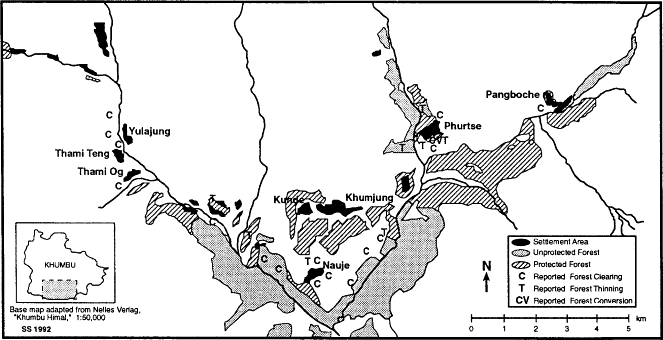
Map 19.
Reported Forest Change before 1965
The continuing preservation of fine forest in the immediate vicinity of villages, however, does reflect an extraordinary continuing commitment in Khumbu to the protection of sacred places and the timely development in some areas of new institutions to protect key sources of certain forest products. The diversity of forest management systems in Khumbu and the relatively large area regulated by them is unequalled among the five peoples who inhabit the Dudh Kosi valley and unparalleled among the Sherpa groups with which I am familiar. Although earlier assumptions about local resource use and management in the Mount Everest region certainly require major revision, Sherpa forest management in Khumbu nevertheless may well remain an example of local resource regulation that is exceptional by Himalayan standards.