Resource Allocation Issues Associated with Maintaining Instream Flow from Wastewater[1]
James R. Vilkitis and Donald R. Woodley[2]
Abstract.—The Chorro Creek study area lacks a comprehensive interagency water management plan. Programs and policies that relate to the missions of the various institutions and agencies involved in its management appear to be crisis oriented. The re-allocation of a water resource use through upgrading of a secondary treatment facility illustrates this approach to planning.
Introduction
At the inception of this study, the authors planned to use the Chorro Creek watershed as a case study area for resource allocation problems associated with competitive uses of a scarce resource: water. The planned approach was to review historical and present consumptive uses of water in the watershed, relative to instream flow and influence upon the riparian system. Of particular concern were the competing uses of water among the private and public riparian landowners during the dry season and the processes by which these uses were allocated water.
At the time, there appeared to be a plethora of information available from public agencies involved with water and its use and from the numerous reports of the watershed's resource. These could be used to construct a water management plan and water budget for the watershed. Upon investigation into the baseline sources, however, it became apparent that much of the information was not available, incomplete, or of poor quality. As a result, the case study deals only with factual information gleaned from public documents; hearsay was unsatisfactory and expert opinion was relied upon only when the source could be documented. Questions related to groundwater storage and yields have not been addressed, simply because adequate data that may be used for rational decisions do not exist.
For these reasons, the study concentrated on Chorro Reservoir (hereafter refered to as the Reservoir) and the waste water treatment plant at the California Men's Colony (WWTP), for which there appear to be enough historical data to give insight into water management of the study area.
Study Area
The main stream of Chorro Creek flows in a northwesterly direction. The 122-sq. km. (47-sq. mi.) watershed is the larger of two basins that drain into Morro Bay on the central coast of California, San Luis Obispo County. The watershed is bordered on the northeast by the Santa Lucia Range and to the southwest by a series of volcanic peaks known as Park Ridge. Two of the peaks (Black Hill and Cerro Cabrillo) form a narrow, through which the creek drains (fig. 1.)
The valley, 0.8 km. (0.5 mi.) wide in some places, varies from rolling hills covered with range grasses to relatively steep slopes at the divides. Three categories of land use were identified. 1) Commercial/residential, which includes Camp San Luis Obispo of the California National Guard (CNG), Cuesta College, and the California Men's Colony (CMC), comprised less than 10% of the area. 2) Agriculture, primarily pasture, comprised approximately 50% of the area, with less than 10% devoted to irrigated crops. 3) Idle land made up the remainder and was in general vegetated, with varying stands of chaparral, conifers and hardwoods. The denser vegetation was located on steeper slopes and in the draws of the basin. There was no urban land (housing developments) in the valley. The agricultural land had very high potential for multiple annual crop production with irrigation. Large landholders included private agriculture ranches, CNG at Camp San Luis Obispo (1,660 ha. [4,100 ac.]), national forest (1,730 ha. [4,276 ac.]), and U.S. General Services Administration (2,374 ha. [5,865
[1] Paper presented at the California Riparian Systems Conference. [University of California, Davis, September 17–19, 1981].
[2] James R. Vilkitis, Ph.D., is Natural Resource Manager, and Donald R. Woodley, Ph.D., is Hydrologist; both are at the School of Agriculture and Natural Resources at California Polytechnic State University, San Luis Obispo, Calif.
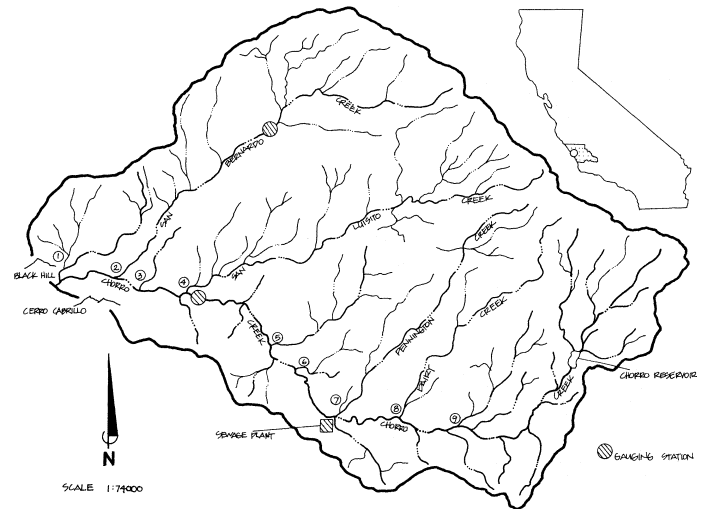
Figure l.
Chorro Creek watershed, San Luis Obispo County, California. (K. Frank.)
ac.]). The latter acquired the land some time after 1963.[3]
Chorro Creek is an intermittent stream with sections exhibiting no surface flow during the dry season (Chappell etal . 1976; Central Coast Regional Water Quality Control Board 1980). Most sub-basins experience flow during the winter and spring. The flow of the main stream is modified by consumptive uses during the dry season and continuously by effluent from the CMC's WWTP located at the junction of Pennington and Chorro creeks (fig. 1). The extent to which each of the sub-basins contributes water to the overall flow regime is not known (table 1.)
Streamflow has been monitored at the Canet Road crossing since November 1978, and on San Bernardo Creek for nine non-consecutive years (1960–65 and 1978–present). The data, however, indicate that the main stream is flashy and irregular. San Bernardo Creek appears to be more stable in its discharge. The gauging station is located upstream and not at the confluence of the San Bernardino with the Chorro (fig. 1). There are no baseline data for the other feeder stream, except for the records kept by CMC for the Reservoir and WWTP discharge.
Infiltration of rainfall appears to occur primarily in the thin residual soil (Henneke soil) of the headwater canyons. The lower alluviated valley (Salinas soil) generates a greater
[3] Machado, H.W. 1981. Personal communication. CNG, Camp San Luis Obispo, San Luis Obispo, Calif.
| ||||||||||||||||||||||||||||||||||||||||||||||||||||||||||||||||||||||||||||||||
proportion of the surface runoff due to layers of silts and clays near the surface.[4]
Geologic faults occur in the watershed (Carollo 1977). Their impacts on groundwater and groundwater movement are not known.
Procedures
No baseline data were generated through organized field research. Scientific literature, public agencies and institutions, private professionals, and local experts were consulted as sources of data. Pertinent information was compiled and assessed as to its validity.
Water resource statistics for the Reservoir were calculated from monthly records supplied by the CMC. Data were only assessed from January, 1962 through December, 1980 (study period), since these were the years that water was being imported from Whale Rock Reservoir on Old Creek and utilized by CMC, with subsequent discharge going into Chorro Creek. Whale Rock Reservoir is approximately 21 linear km. (13 mi.) northwest of the Reservoir. Averages in the tables should be approached with caution since in some cases they were calculated using the number of months where water flowed or was used. For example, during January of the study period, water flowed over the spillway 17 years out of the 19-year period; an average was obtained by dividing total flow over the spillway by 17. Results indicate the average flow for months of flow. Tables present all statistics related to flow and no-flow months.
Statistics for the WWTP were derived from "Repairs and Utilities Operation Log" records supplied by CMC, from July 1966 to June 1975. Reliable data for other time periods were not readily available.[5]
The study area is in a water-deficient region that experiences an average annual rainfall of approximately 560 mm. (22 in.), most of which (75%) falls between 1 December and 31 March. The allocation of water as a resource only becomes a management issue during that portion of the year when water is scarce and demand is great. This is identified as the "dry" period, which extends from May through November. Statistics related to this period are bracketed in the tables by heavier lines.
Results
Comprehensive and/or descriptive baseline data for the natural resources and land-use history of the watershed are not available. The environmental setting was established from information generated from sources specified above.
History
The Reservoir and WWTP are presently operated by CMC and are located within Camp San Luis Obispo, which is the property of the State of California. Established as a National Guard camp in 1928, its control was preempted by the federal government from 1941 to 1946 and from 1951 to 1953. During those periods structures were built that were the property of the federal government. Since 1965, the property has been under state control.
Chorro Dam was completed by the US Army Corps of Engineers (CE) in September 1941 as a device to regulate water imported from Salinas Reservoir (Santa Margarita Lake). Since it was a regulatory device, an appropriation permit from the State Water Resources Control Board (SWRCB), which authorizes construction of projects and uses of water, was not necessary. Over time the use of the Reservoir dam changed from regulation to storage and diversion. On 30 November 1955, the CNG filed an application (16757) for appropriation of water (storage and diversion) to the SWRCB. A permit (11527) was issued in 1958. Subsequently, the CNG made proof (19 July 1963) of a right to use water from Chorro Creek. A license (7844) for diversion and use of water was issued (4 August 1966) for irrigation, domestic, stock-watering, and recreational use. The conditions of the license were as follows:
[4] Mann, J.F. 1977. Correspondence. Consulting Geologist and Hydrologist, La Habra, Calif.
[5] Robasciotti, M. 1981. Communications. Waste water treatment plant, California Men's Colony, San Luis Obispo, Calif.
. . . and that the amount of water to which such right is entitled and hereby confirmed, for the purposes aforesaid, is limited to the amount actually beneficially used for said purposes and shall not exceed one and five-tenths (1.5) cubic feet per second by direct diversion to be diverted from about May 1 to about November 1 of each year for irrigation purposes and throughout the remainder of the year as required for domestic use and one hundred fifty (150) acre-feet per annum by storage to be collected from about October 1 of each year to about May 31 of the succeeding year.
The equivalent of such continuous flow allowance for any thirty-day period may be diverted in a shorter time if there be no interference with other vested rights.
Maximum withdrawal in any one year has been 92 acre-feet.
Licensee shall release or bypass a flow of at least one cubic foot per second into the natural channel of Chorro Creek below the point of diversion whenever the natural flow of the stream entering the Reservoir above the point of diversion is two cubic feet per second or more; and at least one-half of the natural flow into the reservoir shall be bypassed whenever that natural inflow to the Reservoir is less than two cubic feet per second. Releases of water from Licensee's storage will not be required to comply with the foregoing provision.
No devices were available within the Reservoir structure for implementation of the bypass requirement when the Reservoir was less than full. The requirement was met through effluent discharge from the WWTP until 1977, when the conditions of the license were brought to the attention of the California Department of Justice for clarification.
Through mutual understanding among representatives of the California Department of Fish and Game (DFG), CNG, and CMC, a bypass device (syphon) was constructed over the spillway to meet minimum flow requirements when the Reservoir was low. This was implemented during the 1977–78 water year.[6]
The Reservoir is located in the headwaters of Chorro Creek, 4.2 km. (2.6 mi.) upstream from where the creek crosses Highway 1 (fig. 1). Its surface area is approximately 2.8 ha. (7 ac.) with design storage of 150 acre-feet (AF). In 1980 it was estimated that, due to siltation, storage had been reduced to 65 AF. The Operating Engineers Training Trust (Local 12), under license from the CNG, is presently dredging the Reservoir to restore it to its original capacity; the license allows for the training of engineers.[3]
When the US Army preempted its right upon Camp San Luis in 1941, the Salinas Reservoir (approximately 20.9 km. [13 mi.] east) was constructed as the water source. Spent water, upon secondary treatment, was discharged into Chorro Creek (Frank 1963). Information related to the quantity of intake and discharge between 1941 and 1961 was not available. However, during the summer of 1961 the camp drew 500,000 gal. per day (gpd) from Salinas Reservoir to supplement the 300,000 gpd withdrawal from Chorro Reservoir (ibid .). Upon completion and operation of Whale Rock Reservoir in 1962, no water was used from the Salinas watershed.
The secondary WWTP was built on Chorro Creek, 12.9 km. (8 mi.) from Morro Bay, by the US Army at about the same time that the Reservoir was constructed. It was built to serve military purposes and designed to accommodate 1–2 million gallons per day (mgpd) sewage. The effluent discharged directly into Chorro Creek prior to 1 July 1979 was required to meet the following restrictions: 1) average maximum concentration for five-day biochemical oxygen demand (BOD) of 15 mg. per l.; 2) suspended solids of 25 mg. per l.; and 3) total coliform bacteria of 23 MPN per 100 ml.
Chorro Reservoir, the water treatment plant, the storage reservoir, and the sewage plant were leased to the Military Department of California on 1 July 1963; they are currently being operated by CMC under the lease (ibid .). After 20 years of operation through agreement with the former Department of Health, Education and Welfare (HEW), the structures revert to CMC.[7]
By 1969 the Central Coast Region Water Quality Control Board (CCRWQCB) pollution abatement program was being implemented. It was apparent that future effluent discharged at its present quality into Chorro Creek would be unacceptable.[8] As a result, CMC was looking for sources to utilize its effluent. California Polytechnic State University (Cal Poly), recognized the potential for irrigation through a feasibility study conducted in 1970, and, spurred on by the CCRWQBC effluent-recycling scheme, entered into a five-year (January 1972 to December 1976) interagency agreement (ID NO 69) with CMC to utilize the effluent. The nature of usage was not
[6] Younger, E.J. 1977. Correspondence. California Department of Justice, Sacramento.
[7] Salvato, C. 1981. Personal communication. Business Manager, California Men's Colony, San Luis Obispo, Calif.
[8] Gibson, J.C. 1969. Correspondence. California Polytechnic College, San Luis Obispo, Calif.
specified. In August, 1972, Cal Poly constructed a 50-AF storage reservoir to irrigate field crops (sugar beets, silage, corn, and hay). The water was not utilized during that very dry season because downstream landowners were dependent upon the effluent for irrigation. In subsequent years the water was utilized for instructional purposes, through the Agriculture Enterprise Management Program (AEMP) in which students do all of the operations from seedbed preparation to harvesting and marketing. About two-thirds of the field crops are grown on Cal Poly's Chorro Creek Ranch under this program.
The effluent usage arrangement worked so well that it was renewed intoto (ID No. SA69) in January 1977 for another five years, terminating 31 December 1981. In September 1979, a second reservoir (36 AF) was being filled. The philosophy of Cal Poly was to store more water at a time when the creek was high and allow more to go downstream during the dry season. About 100–200 AF of water is stored annually. This irrigates approximately 99 ha. (244 ac.) of land. Effluent is pumped year-round with highest usage occurring between April and September. Approximately 488 AF are used on the Chorro Creek Ranch. Of that amount, 293 AF (60%) comes from effluent; the remainder comes from two shallow wells on the ranch. Since irrigation was brought into the AEMP on Chorro Creek Ranch, 8,596 students spent 215,775 class hours in agricultural instruction.
Chorro Reservoir
Inflow into the Reservoir averages 180 AF per month, most of which (64%) occurs from January through April; 29% occurs during the dry period. The yield for the dry season, based on license restrictions for the average year, is approximately 332 AF. From January 1955 to April 1981, waterflow has been recorded every month. Statistics for the study period are presented by month in table 2.
Of the total flow into the Reservoir, approximately 72% flows over the spillway. Of the amount that spills, 77% occurs from January through April, with 17% occurring between May and November. During the dry period there is no flow over the spillway approximately 44% of the time. In addition, 76% of the no-flow months occur during the dry period (table 2).
Evaporation during the study period totaled approximately 1,097 AF; 72% occurred during the dry period (table 2).
Imported water from Whale Rock Reservoir accounted for 6,762 AF. It was imported 53% of the time. Of the total imported, 83% was brought in during the dry season. The initial safe annual yield for Whale Rock was calculated to be 8,900 AF. Through mutual agreement (1 November 1957), it was proportionally owned for distribu-
| ||||||||||||||||||||||||||||||||||||||||||||||||||||||||||||||||||||||||||||||||||||||||||||||||||||||||||||||||||||||||||||||||||||||||||||||||||||||||||||||||||||||||||||||||||||||||||||||||||||||||||||||||||||||||||||||||||||||||||||||||||||||||||||||||||||||||||||||||||||||||||||||||||||||||||||||||||||||||||||||||||||||||||||||||||||||||||||||||||||||||||||||||||||||||||||||||||||||||||||||||||||||
tion on the following bases: City of San Luis Obispo 4,900 AF (55%); Cal Poly 3,000 AF (34%); and CMC 1,000 AF (11%). Figures presented in table 2 represent the water that is used in the Chorro watershed.[9]
At the 5 June 1974, annual meeting of the Whale Rock Commission, a presentation by California Department of Water Resources (DWR) regarding the Safe Annual Yield Study on the Whale Rock Reservoir led to the lowering of the annual yield. At present it is believed to be 2,300 AF per year.[10]
Waste Water Treatment Plant
Effluent discharge from the WWTP averaged close to 1 cubic foot per second (cfs) throughout the year for the study period. This figure is modified when the minimum and maximum flows are taken into account (table 3). Flow at or above 0.75 cfs generally occurs between the peak hours of 08:00–18:00 throughout the week, rising and falling continuously.[5] Accurate data for hourly flow have not been ascertained, nor are they readily available.
It appears that the effluent discharge has been decreasing through time. In a military report dated 1952, it was stated that low flow of 1 cfs had been reached.[3] Frank (1963) reported that ". . . the surplus effluent flows into Morro Bay." Surplus refers to water downstream from the sewage plant that has not been used for irrigation. In 1969 Cal Poly correspondence estimated discharge at 1.24 cfs.[11]
Robasciotti[5] states that in the last couple of years discharge has been around 0.77 cfs and has averaged up to 1.01 cfs. He believes that this low figure is due to leakage and that the average flow should be around 1.24 cfs.
| ||||||||||||||||||||||||||||||||||||||||||||||||||||||||||||||||||||||||||||||||||||||||||||||||||||||||||||||||||||||||||||||||||||||||||||||||||||||||||||||||||||||||||||||||||||||||||||||||||||||||||||||||||||||||||||||||||||||||||||||||||||||||||||||||||||||||||||||||||||||||||||||||||||||||||||||||||||||||||||||||||||||||||
Upgrading the Waste Water Treatment Plant
Upgrading of the WWTP was partially brought about by an order (No. 75–50) from CCRWQCB, which prohibited discharge of wastewater into Chorro Creek after 1 July 1977.[12] The quality of the effluent did not come up to the requirements of the 1974 Water Quality Act.[13] The Clean Water
[9] Schneider, A. 1981. Communications, California Men's Colony, San Luis Obispo, Calif.
[10] Mayse, R. 1981. Communications. Whale Rock Reservoir, Cayucos, Calif.
[11] Johnson, C. 1969. Correspondence, Cal Poly, San Luis Obispo, Calif.
[12] Jones, K.R. 1976. Correspondence. Central Coast Regional Water Quality Control Board, San Luis Obispo, Calif.
[13] Dupius, R. 1981. Communications, State Water Resources Control Board, Sacramento, Calif.
Grant Program was an opportunity for CMC to upgrade its facility and effectively dispose of effluent within the watershed. Subsequently, procedures to qualify for the grant program were effected. The first two steps in the procedure had been implemented when a major stumbling block was encountered. DFG made known its concern regarding the steelhead trout fishery of Chorro Creek, and its dependence on effluent from the WWTP. Cessation of discharge, one of the alternatives, would allegedly severely alter a considerable portion of the trout's nursery habitat.[13] DFG indicated that at least 0.75 cfs must be maintained to support the fishery.
CCRWQCB staff responded, after review of the CMC draft project report, by considering to revise Order No. 75-50 to permit the discharge of highly treated wastewater to the creek. On 4 March 1977, representatives of DFG, SWRCB, CCRWQCB, and Toups Corporation (responsible for the preparation of an environmental impact report) met in Monterey to define minimum flow requirements necessary to maintain the aquatic habitat of Chorro Creek.[14] It followed that a resolution to the Clean Water Grant Contract regarding the discharge of 0.75 cfs was consumated through agreement of CMC and DFG (30 June 1978). This fulfilled Condition No. 3 of the Concept Approval letter and authorized payment beyond 50% of the step 2 grant.[15]
Some of the effluent characteristics of the upgraded plant are: 1) average maximum concentration for five-day BOD of 10 mg. per l.; 2) suspended solids of 10 mg. per l.; 3) total coliform bacteria 2.2 MPN per 100 ml.; 4) total phosphorus 0.5 mg. per l.; 5) ammonia 4 mg. per l.; and 6) nondetectable chlorine residual.
Water Balance
Total water input into the Reservoir during the dry period averaged 95 AF per month for the study period. Effluent discharge averaged 62 AF per month. The average loss to the system was 33 AF per month. The minimum flow bypass requirement of 0.75 cfs necessitated an average monthly discharge of 45 AF per month. This assumes that the flow of 0.75 cfs can be maintained throughout the day, which is not the case. The discharge fluctuates above and below this figure. The potential yield to Cal Poly is 17 AF per month. Statistics for the mean for imported water months (

| ||||||||||||||||||||||||||||||||||||||||||||||||||||||||||||||||||||||||||||||||||||||||||||||||||||||||||||||||||||||||||||||||||||||||||||||||||||||||||||||||||||||||||||||||||||||||||||||||||||||||
[14] Aleshire, R. Correspondence. Central Coast Regional Water Quality Control Board, San Luis Obispo, Calif.
[15] Rothenbaum, D. 1978. Correspondence. State Water Resources Control Board, Sacramento, Calif.
Discussion
Chorro Creek
It appears that throughout its history Chorro Creek has been an intermittent stream, and that the construction of the Reservoir and WWTP in 1941 created an artificial flow in the creek from water imported initially from Salinas Reservoir and later from Whale Rock. Statements such as:
We recognize that during dry months, most, if not all of the surface water flowing in the lower portion of the creek is from the Men's Colony. (Toffoli)[16]
Almost all of the water in Chorro Creek available to Hollister and other properties in the area consisted of treatment plant effluent. (Chesler)[17]
and:
The California Men's Colony Waste Water Treatment Plant, therefore, constitutes the most significant portion of the Chorro Creek flow during the summer months. (De Falco)[18]
lend strong support to the premise that the fishery may not have been able to survive without the effluent discharge since 1941. It also seems quite feasible that the use of water by Cal Poly through the interagency agreement since 1972 has not destroyed the fishery.
Wastewater
There are some legal restrictions on the ownership of wastewater within the watershed.[13] Basically, if the owner maintains control, as with CMC, it can do as it pleases with the water. When the water is abandoned into the creek, it becomes the property of the people of the state. "Abandoned" is a sticky term, but basically refers to no further intention of use.
Riparial rights deal with the natural flow which exists in the creek. It does not apply to imported water (waste water in this case), water released from storage, or water pumped from underground.[17]
Reservoir Bypass
The bypass license requirement at the Reservoir for maintenance of fish and wildlife habitat commenced 1 October 1977. During that month 750,000 gpd were syphoned over the spillway; the release was lost to evaporation, transpiration and ground infiltration before ". . . the flow reached Highway 1 . . ."[17] This point is approximately 2.4 km. (1.5 mi.) from the Reservoir.
Waste Water Treatment Plant Minimum Flow
The minimum flow requirement of 0.75 cfs during a dry year would require nearly all the effluent discharged from WWTP.[14]
Water Balance with Cal Poly
Approximately 50% of the water entering the Reservoir is imported (Whale Rock and storage); when the mean for the study period (

Water Management
A first step to be taken in managing the Chorro Creek watershed should be computation of a water budget. This would allow the manager to determine the relationship between water from precipitation and the outflow of water by streamflow, infiltration, and evapotranspiration. The water balance technique, as developed in the 1940s by C. Warren Thornthwaite, allows planners to utilize commonly available meteorological records to predict variables such as streamflow, groundwater recharge, or the effects of human activities on the ecology of the watershed.
Unfortunately, there are very few "commonly available, meteorological records" and other sources of information necessary for an adequate assessment of the Chorro Creek hydrologic system. No official meteorologic information has been collected in the watershed, although local residents have maintained records on precipitation, wind direction, and associated data on an irregular basis. However, there are over 100 years of precipitation records for the city of San Luis Obispo, and limited meteorological information is available from Cal Poly, the city of Morro Bay, and the San Luis Obispo County Engineer's Office. These data were made available for a preliminary appraisal of the Chorro Creek hydrologic basin.
[16] Toffoli, E.V. 1977. Correspondence. California Department of Fish and Game, Region 3.
[17] Chesler, A.A. 1977. Correspondence. State Water Control Board, Division of Water Rights, Sacramento, Calif.
[18] De Falco, P. 1977. U.S. Environmental Protection Agency, San Francisco, Calif.
The precipitation data are important. They are the basis for ascertaining the amount of water available in the drainage basin in a given year. Since recording rain gauges have not been in place in the proximity of Chorro Creek for the past several decades, existing data were used to estimate the average annual precipitation. Both the Theissen-weighted average and isohyetal methods were employed to portray and quantify the spatial patterns of precipitation. The results obtained by the Theissen method were evaluated as most representative of the area. These results, however, are strongly biased by the 110-year records of the San Luis Obispo station; these data commonly are the basis for filling information gaps in the Chorro Creek basin.
Evapotranspiration is the largest debit item in the Chorro Creek hydrologic budget. The evapotranspiration statistics are based on Class A evaporation-pan data collected at the Cal Poly weather station. Coefficients relating water use by each vegetation cover-type to the evaporation-pan information were derived from data developed by the University of California, Davis. The evaporation-pan information also provides the basis for calculated evaporation losses.
Surface runoff is a significant portion of the outflow from the Chorro Creek watershed. The calculated runoff is based on minimal recorded information. Incomplete runoff information was obtained for Chorro Creek and San Bernardo Creek. A gauge recently was placed on Chorro Creek, just downstream from the Camp San Luis Obispo boundary (fig. 1). Significant portions of the record for the 1978–79 and 1979–80 water years are missing. Seven years of discharge records were obtained for San Bernardo Creek. Unfortunately, both the main stream flow and the tributary flow are regulated above the respective gauges. This is important since the gauge information cannot reflect natural stream runoff. Residents of the area report that, prior to the construction of impoundments and other regulating measures, after-the-rainy-season flow in the stream was usually absent. These reports may be verified by well data which appear to place the piezometric surface below the streambed. If this information can be verified, Chorro Creek can be shown to be an effluent stream and intermittent in its natural state.
The available streamflow data were plotted on a precipitation hydrograph to obtain runoff/precipitation relationships. This methodology was used to establish that runoff in an average precipitation year may be expected to range between 18.51 hectare meters (HaM) and 25.49 HaM. The midpoint of the range was selected for the drainage basin hydrologic budget.
Data supplied by DWR, the Whale Rock Commission, and the several municipal and industrial water users were utilized to provide the remaining information presented in table 5.
| |||||||||||||||||||||||||||||||||||||||||||||||||||||||||||||||
Water Budget
As with any budget, the hydrologic income and expenditures should balance. However, the calculated inflow exceeds the outflow in the Chorro Creek budget by about 0.57 HaM. This is a relatively small amount of water in this drainage basin. No attempt was made to "adjust" the respective inflow and outflow items to a balance. The difference is simply allocated as "other uses" on the debit side. This amount of water could be easily absorbed by any of the larger inflows or outflows, or it may be retained in the groundwater.
The questions of groundwater storage and yields were not included in this budget, simply because adequate data do not exist which may be used for rational evaluations. Data which will allow construction of analytical models will promote a better understanding of the groundwater basin, the surface water system, and the relation-
ship between the two. It is impossible to provide competent estimates of the available surface water or groundwater yield without this data.
Summary
The Chorro Creek watershed is a water-deficient area. There is a greater potential demand than natural supply. Conflicts exist among competitive users for imported water—the appropriation of which has not been established. Effective resource management requires sound baseline data to evaluate the resource potential and use. It also necessitates a comprehensive understanding of the integrated needs of the competitive users. At this time there appears to be no movement toward a comprehensive watershed management plan, nor interagency or cooperative agreement for implementation of a management scheme. Mechanisms exist to resolve some of the conflicts among agency users and subsequently allow more flow downstream during the dry season. One approach, through cooperative agreement, is to allow more storage during the rainy season. There is ample public land available for the construction of a storage reservoir. The water could be used for low-flow augmentation of the stream and irrigation. Another approach would be to maintain effluent holding tanks. They could serve as a reservoir to equalize streamflow and for irrigation water.
A third approach would involve interagency and cooperative agreement from local and state governments to utilize effluents from outside the watershed (e.g., Morro Bay, San Luis Obispo) in the development of an aquaculture program. The National Aquaculture Act of 1980 (PL 96-362) could be used as the vehicle for construction of stabilization ponds to be used not only to purify water but to harvest biomass. The water, once polished, could serve for low-flow augmentation, irrigation, and groundwater recharge.
Acknowledgments
This case study has involved contact with many and diverse agencies, both public and private. As such, scores of individuals supplied much-needed information, some willingly, others not so willingly. We are grateful for all the help we received and apologize for the discomfort we may have, in particular cases, induced. We deeply appreciate all the support and help provided by the SWRCB, the Division of Water Rights, the Division of Water Quality, CMC, the State Clearing House, DFG, Cal Poly, the city of Morro Bay, the city of San Luis Obispo, and all others that we may inadvertently have not mentioned.
Literature Cited
Carollo, J., Engineers. 1977. Draft EIR for Morro Bay-Cayucos Wastewater Facilities. Walnut Creek, Calif.
Central Coast Regional Water Quality Control Board. 1980. Order No. 80-42, NPDES No. CA0047856 adopted 24 November 1980, for California Department of Corrections, California Men's Colony, San Luis Obispo County. 7 p. Central Coast Regional Water Quality Control Board, San Luis Obispo, Calif.
Chappell, P.P., J.L. Lidberg, and M.L. Johnson. 1976. Report to the State Water Resource Control Board summarizing the position of the Department of Fish and Game on Water Application 24120. California Department of Fish and Game Region 3. 39 p.
Frank, A.F.W. 1963. Statement of mission. US Army Garrison, Camp San Luis Obispo, Calif. T/D 6A-6015.