Protecting Stream Environment Zones to Preserve Water Quality in the Lake Tahoe Basin[1]
Judith E. Unsicker, Charles A. White, Michael R. James, and James D. Kuykendall[2]
Abstract.—Stream environment zones can provide effective natural removal of pollutants in precipitation runoff which would otherwise adversely affect the waters of Lake Tahoe. Human disturbance of some stream environment zones in the Tahoe Basin has drastically reduced their treatment capability. Activities of the California Regional Water Quality Control Board for protecting and restoring stream environment zones are discussed.
Introduction
Lake Tahoe, located at 1,897 m. elevation on the California-Nevada border (figure 1), is celebrated for its size, purity, clarity, and color. It is one of the largest high-altitude lakes in the world, with a volume of 155 billion cubic meters. The immense volume of the lake, and the relatively small size of its watershed (which discharged very low levels of sediment and nutrients to the lake under natural conditions) account for its outstanding water quality. The watershed includes 63 tributary streams. These streams, together with associated marshes, meadows, and riparian woodlands, are known to local planners as "stream environment zones" (SEZs).
Much of the Lake Tahoe Basin is in public ownership, but development of private lands, including large marsh and meadow areas throughout the basin, has been intensive during the last 25 years. About 10% of the watershed has been urbanized or otherwise disturbed. Increased residential and commercial development has been paralleled by increased phytoplankton productivity in open waters and nearshore periphyton growth. Phytoplankton primary productivity in 1980 was approximately twice that observed in the mid-1960s (Leonard and Goldman 1981).
These changes in productivity are the result of increased nutrient loadings to the lake caused by the increases in erosion and urban runoff flows which accompanied the development. In addition to these direct increases in nutrient loading, the disturbance of SEZs actually causes a reduction or complete loss in the capability of many SEZs to reduce nutrient levels in precipitation runoff through natural filtration, sedimentation, and adsorption processes (Tahoe Regional Planning Agency 1977; California Water Resources Control Board 1980).
The California Water Resources Control Board (State Board) and the California Regional Water Quality Control Board, Lahontan Region (Regional Board) are the state agencies responsible for protecting the water quality of Lake Tahoe and its tributaries through policy making, planning and enforcement activities. These boards cooperate with a number of federal, state and local agencies, including the bistate Tahoe Regional Planning Agency (TRPA), which recently adopted a bistate water quality plan. This paper summarizes State and Regional Board efforts to protect SEZs in the Lake Tahoe Basin—for their intrinsic value and for the protection of Lake Tahoe.
Definition and Importance of Stream Environment Zones
In 1971, the USDA Forest Service (FS), cooperation with the TRPA, mapped the soils a geomorphic characteristics of the Lake Tahoe Basin. This information was subsequently used by the FS and TRPA to construct a land capability system. Land capability was defined as: "the level of use an area can tolerate without sustaining permanent damage through erosion and other causes" (Bailey 1974). The system includes seven classes, with Class 1 being those lands which should be kept in their natural state a Class 7 lands rated the most tolerant of distur-
[1] Paper presented at the California Riparian Systems Conference. [University of California, Davis, September 17–19, 1981].
[2] Judith E. Unsicker is Environmental Specialist, Michael R. James is Senior Water Resources Control Engineer, and James D. Kuykendall is Supervising Water Resources Control Engineer; all are with the California Regional Water Quality Control Board, Lahontan Region, South Lake Tahoe, California. Charles A. White is Regional Administrator, Hazardous Material Management, Department of Health Services, Berkeley, California.
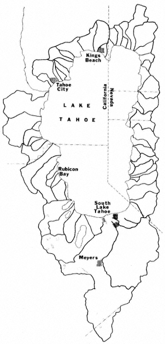
Figure l.
Map of Lake Tahoe Basin, showing
watershed boundaries (after Tahoe
Regional Planning Agency 1977).
bance (table 1). For each class, a maximum recommended percent coverage from developmental activities (e.g., paving, roof area) was prescribed as part of the land capability system. Class 1 lands were further broken down into three subclasses: 1a—high erosion hazard lands; 1b—lands with poor natural drainage; 1c—lands with fragile flora and fauna. Class 1b lands were defined to include "stream channels, marshes, flood plains, and meadows" (ibid .).
| |||||||||||||||||||||||||||
SEZs, as defined in a later study (Tahoe Regional Planning Agency 1977), are essentially equivalent to Class 1b lands, although the determining criteria have been expanded in some respects. As mapped for the TRPA Water Quality Management Plan (ibid .), SEZs include the broadest of the following limits: streams, lakes, ponds; areas of alluvial soil; the 100-year floodplain; areas of riparian vegetation; a minimum buffer strip (7.5 to 30 m. [25 to 100 ft.]) with width dependent upon stream order (figure 2).
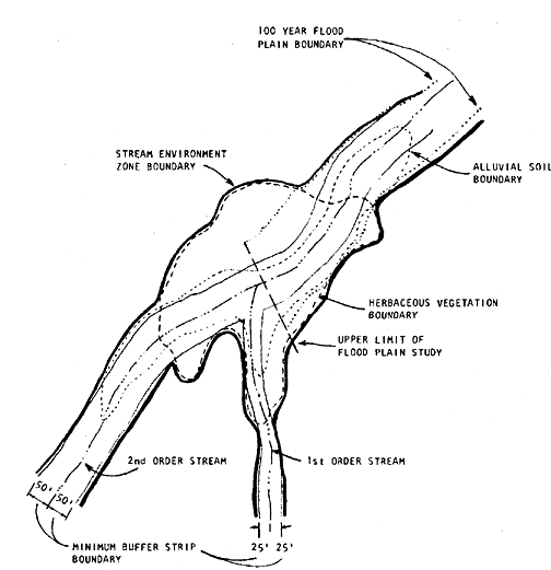
Figure 2.
Idealized stream environment zone (SEZ), showing
criteria used in determining boundaries (after
Tahoe Regional Planning Agency 1977).
SEZs in the Lake Tahoe Basin are important both as examples of comparatively rare ecosystems (e.g., the quaking bog at Grass Lake), and as fish and wildlife habitat. The Western Federal Regional Council Interagency Task Force (1979) termed SEZs "key wildlife habitats". The ability of SEZs to remove pollutants from precipitation runoff was measured by the TRPA (Tahoe Regional
Planning Agency 1977) and by the Environmental Protection Agency (EPA) (Morris etal . 1980). The TRPA study showed 94% removal of suspended solids, 74% removal of total nitrogen, 86% removal of total phosphorus, and 72% removal of iron as runoff passed through an undisturbed SEZ.
The EPA study compared SEZs having different kinds and amounts of disturbance, and concluded that meadowlands can provide effective treatment of runoff under certain circumstances. Sheet flow, as opposed to channelized flow, results in the best treatment; beaver dams may aid in achieving such flow. Extensive grazing alters the filtration capability of meadow lands, and may accelerate leaching of soil nutrients. The authors emphasized the importance of monitoring during storm events; the most dramatic reductions in sediment and nutrients were associated with storms rather than with monitoring of runoff at regular intervals.
The History of Human Influence on Stream Environment Zones
The Lake Tahoe Basin provided summer hunting and fishing grounds for the Washoe and Paiute Indians; a number of important archaeological sites are associated with SEZs. Early white settlers pastured their livestock in basin meadows. Much of the basin was logged in the nineteenth and early twentieth centuries. Early resorts were usually associated with riparian zones. All of these activities must have altered SEZs to some extent. However, extensive permanent disturbance began only in the 1950s and 1960s with the development of the Tahoe Basin as a center for winter skiing and casino gaming. These attractions stimulated road construction and residential and commercial development, most intensively at the south shore of the lake. Much of this construction took place in SEZs and included an airport, golf courses, sewerlines, a sanitary landfill, and a quarry, as well as motels, shopping centers, and residential areas on filled SEZ land. The most drastic alteration was the dredging and filling of 140 ha. (340 ac.) of the Truckee Marsh to create the Tahoe Keys subdivision. The Western Federal Regional Council Interagency Task Force (1979) estimates that since 1900, 35% of the riparian streamside zones, 50% of the meadows, and 75% of the marshes in the Lake Tahoe Basin have been lost to development. Between 1969 and 1979 alone, 25% of the marshes were developed.
All of this development produced a variety of disturbances including channelization and rerouting of streams, increased streambank erosion, disturbed soil and vegetation with loss of natural nutrient filtration capability, increases in impervious surface and surface runoff; and additions to surface waters and groundwaters of fertilizers, pesticides, and deicing agents. By the early 1970s over 40,000 dwelling units and an additional 30,000 vacant lots existed in subdivisions which were approved and constructed prior to the development of the land capability system. In some urbanized areas, total coverage exceeded 90%.
As the more level private lands (largely SEZs) were developed, demand grew for construction on steeper slopes (capability classes 1–3). Sewering of the basin by the early 1970s facilitated development on soils which were unsuitable for septic tank/leachfield systems. On many class 1 lands, where land coverage should be limited to 1%, coverage currently exceeds 50%. Development of these fragile lands led to increased sedimentation in SEZs, even when there was no direct encroachment on the SEZ.
Table 2, from the TRPA study (Tahoe Regional Planning Agency 1977), compares the water quality of tributaries of Lake Tahoe with disturbed and undisturbed watersheds. Further documentation of the siltation problem was provided by several other investigators (California Resources Agency 1969; Kroll 1976; Glancy 1976). All of these studies demonstrated that sediment and nutrient discharge was much greater from disturbed than from undistrubed watersheds. Furthermore, these studies provided evidence that sediment and nutrient yields from watersheds undergoing development have a tendency to increase markedly as construction activities encroach on lower capability lands. Present sediment and nutrient loadings to Lake Tahoe are estimated to be equivalent to those from an undisturbed watershed 10 times the size of the Lake Tahoe Basin.
| ||||||||||||||||||||||||
Work by the Tahoe Research Group (e.g., Goldman 1974) showed that suspended sediments could stimulate algal growth both as sources of dissolved nutrients and as substrates for heterotrophs which increase the rate of nutrient cycling.
Two studies by the State and Regional Board staffs contributed to the understanding of the effect of construction on sediment levels. Baker and Davis (1976) sampled benthic invertebrates in streams in and near the Tahoe Basin, above and below disturbed areas including subdivisions, road cuts, ski trails, and a large unpaved parking lot. Compared to reference stations, stations downstream of disturbed areas showed significant decreases in numbers, diversity, and
standing crop of benthic macroinvertebrate organisms.
White and Franks (1978) compared sediment and nutrient loadings to streams from the poorly-planned Rubicon Properties subdivision on the west shore of Lake Tahoe with loadings from the carefully planned Northstar-at-Tahoe development just north of the Tahoe Basin. In the former development, roads, driveways and homesites had been graded with little or no attempt at erosion and drainage control. Road cuts at Rubicon were up to 30–40% and 24 m. (80 ft.) high. Full buildout of Rubicon Properties would lead to an eventual 55% land coverage within the subdivision, although the land capability system would restrict development of such high hazard (class 1) lands to only 1% coverage. These disturbances, and later the installation of sewerlines, contributed sediment to Lonely Gulch Creek, which flows through the subdivision. Total sediment loadings were 100 times natural background levels with drastic impacts on benthic invertebrate populations.
At Northstar-at-Tahoe, the ski area and condominiums were located away from SEZs and high erosion hazard lands, and "best management practices" (BMPs) for erosion and drainage control were employed from the beginning. Sediment loadings after construction were estimated to be only two to three times background levels, and there was very little impact on benthic invertebrates of Martis Creek. One of the major conclusions of the work conducted by White and Franks (ibid .) was that the most important BMPs for the protection of water quality in a SEZ are limitation of development activities to conform to land capability and exclusion of significant development activities from the SEZ itself.
History of Water Quality Planning
In the mid-1960s, concern over the nutrient contribution to Lake Tahoe from domestic wastewater led to negotiations between California and Nevada. These negotiations eventually resulted in the export of sewage and solid waste from the basin, and the creation of the bistate TRPA. The Regional Board's Lake Tahoe Policy (California Regional Water Quality Control Board, Lahontan Region 1967) was concerned mainly with the sewage issue. It recognized the siltation problem, and supported land-use control actions by the State Legislature and local governments. However, it provided relatively little authority for Regional Board enforcement authority. A 1970 addendum to the policy, and the Water Quality Control Plan (Basin Plan) adopted in 1975 included prohibitions on the discharge or threatened discharge of wastes, including earthen materials, to Lake Tahoe and its tributaries, or within their 100-year floodplains. At that time, the land-use planning agencies, the TRPA, and the California Tahoe Regional Planning Agency (CTRPA) enacted ordinances which downzoned many of the SEZs and regulated grading, vegetation disturbance, and shorezone construction. However, the political situation led to "grandfathering" of development rights, and frequent granting of variances. Encroachment into SEZs continued.
In 1974 the TRPA was designated by California and Nevada as the "Section 208" planning agency for the Tahoe Basin under the Clean Water Act. In 1977 TRPA released a draft Water Quality Management Plan which identified development in SEZs, on high erosion-hazard lands, and in excess of land capability coverage limits as the major sources of water quality problems in Lake Tahoe and its tributaries. This plan recommended strict controls on new development and remedial erosion- and drainage-control projects to remedy impacts of existing development. Unfortunately, the final plan lacked commitment and funding for implementation of these controls. The State Board revoked TRPA's Section 208 planning designation and prepared its own water quality plan for the California portion of the Tahoe Basin (California Water Resources Control Board 1980). The Regional Board was given responsibility for implementing this plan. The major provisions of the State Board plan have been incorporated into the amended bistate plan recently adopted by TRPA. The Regional Board will continue to implement the State Board plan in California.
Prohibitions on Development
The State Board plan, pursuant to authority granted by Sections 13170 and 13243 of the Porter-Cologne Act, prohibits discharge of sediment and other waste materials from new subdivisions, and from any new development or construction activities which occur in SEZs or exceed land capability coverage limits, or which are not offest by remedial erosion- and urban runoffcontrol measures for existing problems. The prohibitions effectively preclude development on land capability classes 1, 2, and 3, where coverage limits are 1–5%. Approximately 7,100 lots in California, 2,100 of them in SEZs, are affected by this prohibition. The Regional Board may grant a variance from the prohibitions for projects found to be reasonably necessary for public health, safety, or recreation; or for implementation of the Nonattainment Air Quality Plan (California Air Resources Board 1979). An example of such a variance was granted for a proposed bicycle trail through a SEZ—part of the regional transportation system recommended by the Air Quality Plan. All possible mitigation and offset measures would be required for such projects.
The State Board plan directs local governments, or, alternatively, the Regional Board, to adopt offset policies specifying the amount of correction of existing problems to be required as a condition of approval of new development. The policies could require phasing development each year dependent upon accomplishment of erosion control work to date, and/or collecting an offset fee from each developer. Offset could include financial or institutional contributions toward the restoration of disturbed SEZs. Offset mea-
sures are to be over and above the remedial projects required by the State Board plan.
No offset policies have been adopted to date. However the TRPA has recently established a mitigation fee schedule for construction projects in the Lake Tahoe Basin. These fees meet most of the requirements of the offset strategy contained in the Lake Tahoe Basin Water Quality Plan. Mitigation fees for a single family house on high capability land, for example, would be $750. These fees will generate revenues of about $700,000 per year for the construction of erosion and urban runoff control projects in the California portion of the Lake Tahoe Basin.
In practice the development prohibitions in this plan are being enforced mainly by local and regional governments. The Regional Board participates in their development review processes at the staff level, and makes its own findings in the cases of proposed variances and waste discharge requirements.
Waste Discharge Permits
The Regional Board has the authority to issue waste discharge requirements under California law, or National Pollutant Discharge Elimination System (NPDES) permits under federal law for any activity involving potential discharge of wastes into the state's waters. Under the State Board plan, waste discharge requirements may be issued for single family homes as well as for commercial and public projects in the Lake Tahoe Basin. Such permits may prescribe specific erosion and drainage control measures, set limitations for chemical constituents in surface runoff, and/or require reporting of failure of controls to the Regional Board. Lack of compliance with waste discharge requirements may result in cleanup and abatement orders, cease and desist orders, or judicial enforcement by the state Attorney General.
The State Board plan directs the Regional Board to revise discharge permits for sewage agencies in the Tahoe Basin to preclude their serving new development which is in violation of the development prohibitions in the plan. These revisions are in progress. The State Board plan also directs the Regional Board to issue NPDES permits for storm drains into Lake Tahoe.
Remedial Erosion and Drainage Control Projects
The State Board plan includes a priority list of remedial projects to be undertaken by federal, state, and local agencies over a 20-year period. They include revegetation of areas stripped of vegetation, mechanical stabilization and revegetation of oversteepened and unvegetated roadway slopes, stabilization of eroding dirt roads, roadway shoulders and ditches, and storm drainage controls. The State Board has allocated $10,000,000 for these projects, to be used as matching funds for EPA Clean Lakes Grant money and local funding sources. To date over $2,000,000 of projects are in the process of being funded. None of the present projects directly affects SEZs. However, all erosion and urban runoff control projects are expected to create substantial reductions in the levels of sediment and nutrient discharges to the SEZs of the watersheds in which the specific projects are located. In the future these funds may be used directly for major SEZ restoration.
Monitoring
The State and Regional Boards are participants in a comprehensive interagency monitoring program which also includes the University of California, Davis, Tahoe Research Group; the California Department of Water Resources; the California Department of Transportation; the FS; and the USDI Geological Survey.
Algal productivity in nearshore and offshore waters of Lake Tahoe, as well as precipitation chemistry, flows, and water quality of tributary streams are being measured in this monitoring effort. Baseline data being collected now will aid in evaluation of the effectiveness of the control measures discussed above.
In 1981 the Regional Board expects to initiate its own surface runoff monitoring program which will include disturbed and undisturbed watersheds, individual commercial discharges, and storm drain systems. This program will be used by the Regional Board to obtain a more accurate assessment of the impacts of development and intense urbanization on the water quality of Lake Tahoe and of the SEZs of the Lake Tahoe Basin.
Restoration of Disturbed Stream Environment Zones
Where encroachments into SEZs have been permitted in the last decade, in most cases some level of mitigation measures have been required to offset the effects of the encroachment. Such measures, as specified in waste discharge requirements adopted by the Regional Board, include stabilization of soils disturbed during construction, and installation and maintenance of facilities to filter virtually all precipitation runoff from man-made impervious surfaces.
The FS has taken the lead in watershed restoration activities in the Lake Tahoe Basin. Significant projects to date have included leachate control at an abandoned landfill in a SEZ, restoration of natural water levels in a partially drained bog, and revegetation and installation of drainage controls in a meadow where casino development had begun.
SEZs will be a high priority for FS acquisition under the Santini-Burton program, which provides money for the buyout of environmentally sensitive lots. Additional money for public acquisition of SEZs and other fragile lands could
be available from a proposed California bond issue. The City of South Lake Tahoe is considering buying SEZs with park funds. Acquisition under these proposals would be on a willing seller basis, although it has been suggested that public agencies could acquire SEZs through the power of condemnation.
Other possible means of facilitating preservation and restoration of SEZs include transfer of development rights, easements, and amortization and eventual removal of existing structures (Tahoe Regional Planning Agency 1975).
Man-Modified Stream Environment Zones
The State Board plan recognizes that some SEZs have been so drastically altered that they no longer exhibit the characteristics of SEZs, and that restoration may be impractical. It allows the Regional Board to reclassify such areas, permitting further development provided adequate offset and mitigation measures are undertaken. Such measures would appropriately include restoration of some of the lost SEZ treatment capability through correction of SEZ problems elsewhere in the basin.
In 1982 the Regional Board will be asked to consider whether or not, or under what conditions further development of the Tahoe Keys subdivision should be permitted. If continued development is allowed, mitigation and offset measures might include one or more of the following:
1) continued operation and/or expansion of the existing water treatment and circulation system for the Tahoe Keys lagoon;
2) use of the remaining portions of the Truckee Marsh for natural treatment of surface runoff from developed areas;
3) restrictions on construction, landscaping, and gardening practices to minimize nutrient loadings to surface waters from runoff and groundwater percolation;
4) financial and/or institutional contributions to erosion and drainage control projects elsewhere in the basin—including restoration of sheet flow over meadows in channelized portions of the Upper Truckee River drainage, or correction of runoff problems in the urbanized Tahoe Valley drainage (both drainages were originally tributary to the Tahoe Keys area).
Conclusion
State and federal nondegradation regulations require that the existing high quality of Lake Tahoe's water be preserved, and enhanced if possible. Development restrictions and remedial control measures being implemented in the Tahoe Basin are believed to be absolutely necessary to prevent further degradation of water quality in the lake and its tributaries. The State Board plan emphasizes that further restrictions on growth and additional remedial projects are needed to reverse the degradation which has already occurred. The TRPA is now evaluating existing data in order to determine environmental threshold carrying capacities for a number of parameters including water quality. It will revise its regional plan, including land use controls, to reflect the limits. It is to be expected that protection and restoration of SEZs will continue to have high priority.
Literature Cited
Bailey, R.G. 1974. Land capability classification of the Lake Tahoe Basin, California-Nevada. 32 p. USDA Forest Service/Tahoe Regional Planning Agency, South Lake Tahoe, California.
Baker, J.A., and W.E. Davis. 1976. Siltation evaluation investigation for the Lake Tahoe Basin. 58 p. California Regional Water Quality Control Board, Lahontan Region, South Lake Tahoe, California.
California Air Resources Board. 1979. Lake Tahoe Basin control strategy revisions to State of California implementation plan for the attainment and maintenance of ambient air quality standards. 268 p. with appendix. California Air Resources Board, Sacramento.
California Regional Water Quality Control Board, Lahontan Region. 1967. Lake Tahoe water quality control policy. 38 p. California Regional Water Quality Control Board, Lahontan Region, Bishop, California.
California Regional Water Quality Control Board, Lahontan Region. 1975. Water quality control plan, North Lahontan Basin (6A). 533 p. California State Water Resources Control Board, Sacramento.
California Resources Agency. 1969. Sedimentation and erosion in the Upper Truckee River and Trout Creek watershed, Lake Tahoe, California. 50 p. California Department of Conservation, Sacramento.
California State Water Resources Control Board. 1980. Lake Tahoe Basin water quality plan. 378 p. California State Water Resources Control Board, Sacramento.
Glancy, P.A. 1976. A reconnaissance of streamflow and fluvial sediment transport, Incline Village area, Lake Tahoe, Nevada. USDI Geological Survew Water Resources Information Series Report 23, Carson City, Nevada. 47 p.
Goldman, C.R. 1974. Eutrophication of Lake Tahoe emphasizing water quality. EPA 660/3-74-034. 408 p. US Environmental Protection Agency, Corvalis, Oregon.
Kroll, C.G. 1976. Sediment discharge from highway cut slopes in the Lake Tahoe Basin, California. USDI Geological Survey, Water Resources Investigations 76-19. Menlo Park, California. 90 p.
Leonard, R.L., and C.R. Goldman. 1981. Interagency Tahoe monitoring program first annual report, water year 1980. 100 p. Tahoe Research Group, Institute of Ecology, University of California, Davis.
Morris, F.A., M.K. Morris, T.S. Michaud, and L.R. Williams. 1980. Meadowland natural treatment processes in the Lake Tahoe Basin: a field investigation. 180 p. US Environmental Protection Agency, Environmental Monitoring Systems Laboratory, Las Vegas, Nevada.
Tahoe Regional Planning Agency. 1975. TRPA 208 program, draft work element report. 243 p. Tahoe Regional Planning Agency, South Lake Tahoe, California.
Tahoe Regional Planning Agency. 1977. Lake Tahoe Basin water quality management plan (amended 1981). 4 volumes and amending ordinances. Tahoe Regional Planning Agency, South Lake Tahoe, California.
Western Federal Regional Council Interagency Task Force. 1979. Lake Tahoe environmental assessment. 240 p. Western Federal Regional Council, San Francisco, California.
White, C.A., and A.L. Franks. 1978. Demonstration of erosion and sediment control technology, Lake Tahoe region of California. EPA 600/2-78-208. 405 p. US Environmental Protection Agency, Cincinnati, Ohio.