Management of Cultural Resources in Riparian Systems[1]
Patricia Mikkelsen and Greg White[2]
Abstract.—Prehistoric inhabitants of California's North Coast Ranges utilized riparian systems in patterns reflecting cultural and natural environments. Archaeological investigations seek to define these prehistoric cultures and paleo-environments and preserve their remains. The status of archaeology under federal and state legislation can help preserve and protect both cultural and natural resources.
Introduction
Cultural resources are broadly defined as "districts, sites, buildings, structures, and objects, significant in American history, architecture, archaeology, and culture."[3] They are important non-renewable features of scientific, social, and historic value that often occur within riparian systems. Prehistoric archaeological sites are among the cultural resources found there and are the primary concern of this paper.
An archaeological site (the location of past cultural activities) contains evidence of adaptation to a local environment. Archaeological data in California, along with ethnographic information (gathered from living people), have revealed complex native American cultures with settlement patterns and land-use practices that gave an integral role to the abundant riparian vegetation, wildlife, and water supplies (fig. 1). From this perspective, studies of the component aquatic and riparian systems comprising these ecosystems are important for archaeological interpretation, as native Americans were an integral part of such systems.
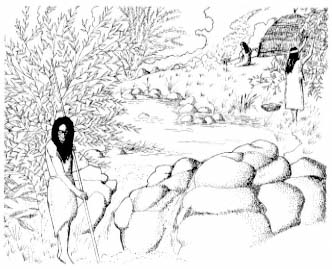
Figure 1.
Native American activities in a riparian system.
The management of cultural resources has become an important part of the land-use planning process; resource conservation is the ideal and the primary goal. Excavation of a site for mitigation of impact when the site is threatened is a form of destruction of that site. Though artifacts kept buried in the ground have little appeal to the public (which can be a vital force in preservation efforts), it is only by slowing the rate of loss of cultural material that we will be able to utilize the new information and techniques that will inevitably be discovered in the future. The preservation of archaeological sites and their context is therefore vital for archaeology. In turn, the management of cultural resources, as a result of various federal and state laws, can be a factor in helping to manage and preserve riparian systems.
Settlement Patterns and Riparian Resources
The following discussion will show how there is some degree of patterning and hence predictability in the location of archaeological resources, specifically with regard to riparian systems.
[1] Paper presented at the California Riparian Systems Conference. [University of California, Davis, September 17–19, 1981].
[2] Patricia Mikkelsen is a Graduate Student in Cultural Resource Management; Greg White is Staff Archaeologist; both are at Sonoma State University, Rohnert Park, Calif.
[3] 36 CFR 60.2.
In California's North Coast Ranges, most native American groups were characterized by a sociopolitical organization known as the tribelet. The tribelet was composed of a large nuclear village and several smaller hamlets. Within the tribelet territory were many sites that served as camps for those acquiring resources, as well as sites that were the locations for resource processing. Although native Americans of the North Coast Ranges practiced no formal agriculture, complex systems of maintenance and management of the resource-rich habitat were employed. For present purposes, native American resource management can be divided into two kinds: 1) direct alteration of the environment, such as the use of deliberate fires (Lewis 1973), altering streamcourses (Kroeber 1925), or preparing root beds for basketry material (Peri and Patterson 1976); and 2) indirect alteration of the environment, such as limiting the intensity and area of hunting, establishing fishing intensity and privileges along certain streams, or social divisions of labor that responded to the seasonal availability of many resources.
The Lake Miwok tribe, whose territory included Anderson Marsh in southeastern Clear Lake (Lake County), California, followed an annual cycle of population dispersal and re-consolidation that conformed with availability of food resources (Callaghan 1978). During winter months, the Lake Miwok stayed in permanent villages and hamlets that were located along year-round watercourses. Large villages such as these often were established at the confluences of major streams or rivers. During the stay in villages, people relied upon stored foodstuffs, although deer, tule elk, and especially waterfowl hunting were productive. In the spring, Lake Miwok continued to inhabit the villages and hamlets, but small parties went out to collect young, tender greens, and to fish for stream-run suckers and pike. In the summer and fall, most of the population of the village and hamlet communities would move to small family campsites in the hinterland. Nearly always, hinterland sites were located next to permanent water sources. Expeditions for resource collecting from the summer campsites were similar to those conducted from the main village, although a great deal of the collecting of materials for tools and goods took place during the summer and fall. The principal activities of hunting and fishing were also replaced in the fall by acorn collecting and processing (fig. 2).
As the Lake Miwok example shows, year-round water sources were used as locations of settlements, and riparian resources were utilized in each season. Archaeological research seeks to document land-use patterns, their changes through time, and the stimulus for these changes, and must recognize that sites within riparian systems were simply a part of a larger system that excluded few of whatever resources were present within the territory of a given tribelet.
Supportive Legislation for Archaeological Research
The value of archaeological research and knowledge has been increasingly recognized, beginning with the Antiquities Act in 1906[4] when an attempt was first made to legally protect artifacts. Since then, not just single artifacts, but archaeological sites have come under the protection of federal and state law and have taken their place along with other environmental resources considered for protection when development is to take place. Therefore, the presence of archaeological sites adds to the environmental evidence that urges protection for riparian systems.
The Historic Preservation Act of 1966[5] created the National Register of Historic Places. The Code of Federal Regulations (CFR) set out the functions of the Register to "identify the nation's cultural resources and indicate what properties should be considered for protection from destruction and impairment".[6] Executive Order 11593 attempted to tie together the legislation affecting cultural resources, requiring an inventory to determine eligibility to the National Register. The National Register serves only as a planning document; a listed site is not ensured of preservation. The site will, however, be taken into consideration early in any design plan with federal funding, permit, or land. Also, sites not on the register cannot be excluded from protection if they warrant it. The National Environmental Policy Act of 1969 (NEPA),[7] and the 1970 California Environmental Quality Act (CEQA),[8] directly involved cultural resources in the planning process. CEQA was formulated in part to preserve ". . . examples of the major periods of California history".[9] To clarify the phrase, the California Secretary of Resources and the California Superior Court stated that environmental impact reports should include a section on archaeological significance (King etal . 1973) and "history" has since been defined to include prehistory, or pre-European periods.
Archaeology in the Planning Process
Cultural resource management should ideally come at the earliest stages of the planning process for proposed developments. In this way it can work towards avoiding threatened sites rather than permitting any destructive impacts or requiring mitigation. Archaeological site inventories and mapping can be especially useful to
[4] Antiquities Act of 1906; PL 59–209, 34 Stat. 225; 16 U.S.C. 431–433.
[5] PL 89–665; 80 Stat. 915; 16 U.S.C. 470 etseq .
[6] 36 CFR 60.2b.
[7] PL 91–190; 83 Stat. 852; 42 U.S.C. 4321–4347.
[8] PRC Section 21000–21176.
[9] Section 21001 Public Resources Code.
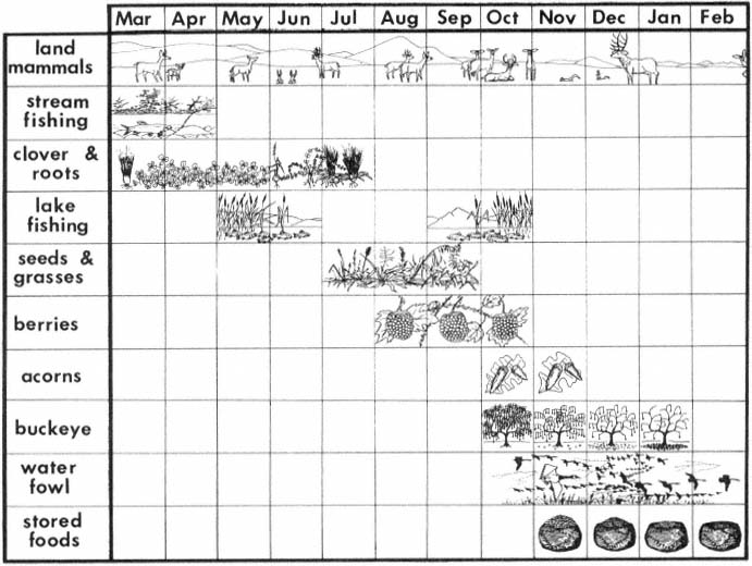
Figure 2.
Seasonal resource calendar of the Lower Lake District.
many areas of study, as they supply updated information on archaeological site distribution and can be used for advance planning and research.
The Northwest Information Center of the California Archaeological Inventory, located at Sonoma State University, is an outgrowth of the California Archaeological Survey of the University of California, Berkeley, (established by R. Heizer and now under the control of Department of Parks and Recreation [DPR]) and the Regional Clearinghouse (established by the Society for California Archaeology for the purpose of processing archaeological impact reports and serving as archives for archaeological papers). The document review section is an outreach program for Sonoma and other counties; it reviews applications for development by evaluating archaeological sensitivity and making recommendations for preservation and protection of archaeological resources. Not only does this office, and others throughout California, provide information early in the planning process, they are also able to generate predictive models for site distribution in various regions.
Two of the basic criteria used by the Northwest Information Center for evaluating archaeological sensitivity are proximity of the proposed project to water and/or the existence of ecotones. If a proposed project is along or near a water system, especially one with pronounced ecotones, a survey is generally recommended, unless the terrain is too steep for habitation or use, or other negative criteria exist. Such environments have been found to be archaeologically sensitive. Another source for determining archaeological sensitivity is the ethnographic maps and records of anthropologists and other researchers who worked among native Americans in the late 1800s and early 1900s and recorded the locations of their villages and campsites. As noted in fig-
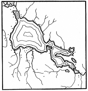
Figure 3.
Distribution of village sites at Clear Lake
(Lake County), California (after Barrett, 1908).
ure 3, the sites were often heavily concentrated around lakes and along rivers and streams.
In addition to site-specific review, archaeological sensitivity studies have been developed for districts and regions. One such study in the North Sonoma Valley, Sonoma County, found, as expected, that riparian zones were particularly archaeologically sensitive (Mikkelsen 1980).
According to maps and literature on file at the Northwest Information Center of the California Archaeological Inventory, 47 surveys have been conducted in the 20,240-ha. (50,000-ac.) North Sonoma Valley, covering 10% of the study area. Approximately 80% of the sites discovered in the valley were along streamcourses. Although the surveys have concentrated on riparian zones and other areas have not been thoroughly studied, riparian corridors were clearly shown to be archaeologically sensitive areas. Also, information from Barrett's ethnographic map (1908) revealed villages at the headwaters of two major creeks in the valley. Kroeber's (1925) settlement map showed four villages spread along the banks of one of the creeks.
On the basis of this evidence, it was recommended that 304-m. (1,000-ft.) boundaries along streams be marked as particularly sensitive for archaeological purposes. This rating would not necessarily save a site in a riparian zone, but it would give planners advance knowledge of the recommendations pertaining to archaeology, and archaeological sensitivity could be taken into consideration when plans are formulated. This would avoid costly mitigation efforts and perhaps result in the preservation of an archaeological site and its riparian context.
Archaeology and Riparian Preservation
An example of an archaeological investigation that was able to contribute significantly to halting the decline of riparian resources occurred near Clear Lake. An archaeological survey was performed along Cache Creek in Anderson Marsh, along the route of a proposed levee construction planned by the Sacramento District, US Army Corps of Engineers (CE). Cache Creek is the only outlet for Clear Lake in recent history; it flows through the marsh at the southern end of the lake. This marsh/lakeshore environment supports tule, cattail, and bulrush as well as numerous birds and other wildlife (fig. 4).
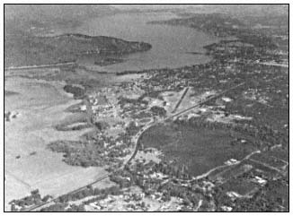
Figure 4.
Aerial view of Cache Creek, Anderson Marsh, and Clear Lake.
The area also contains numerous archaeological sites: native American villages, campsites, and specific-task sites. Ten prehistoric sites were observed along the proposed levee route during the archaeological survey (Fredrickson and Parker 1977). Artifacts such as milling stones, handstones, mortars and pestles, and projectile points were identified. The significance of the sites to the understanding of local, regional, and state prehistory resulted in their being listed in the National Register of Historic Places. As all sites would be adversely affected by the CE project, the primary recommendation was that the areas of the project containing sites be avoided.
The marsh, surrounding lakeshore and watershed, and three islands have recently been acquired by the State as a cultural and natural preserve. The archaeological sensitivity of the
area played an important part in the decision, with 15% of the allocated funds proposed for a cultural heritage preserve.[10] By assessing all environmental variables concurrently, a major case was made for protection of endangered cultural and natural resources.
Archaeological Research and Riparian System Studies
Many research questions identified and addressed by archaeologists are developed with data that would be of interest to riparian system researchers. Of particular interest are archaeological efforts to reconstruct extinct local and regional biotic communities. Not only has the changing environment of the prehistoric North Coast Ranges influenced the logistics of settlement patterns, as for example in the shifting of a base camp location to follow a migrating ecotone, but changing environments may have greatly influenced departures from tradition to implement new diets, technologies, and social and cultural systems among the native peoples. The reconstructions of paleo-environments have become a valuable explication and independent test of archaeological inferences.
An example of the research potential for interdisciplinary study of archaeological data comes from D.A. Fredrickson's analysis of CCO308, a prehistoric native American site near Alamo in Contra Costa County. The investigation of that site was undertaken in 1963 and served as the basis for Fredrickson's Masters Thesis (Fredrickson 1966). Excavations at the site were for salvage purposes. The site was in the path of a rechannelling of San Ramon Creek. The new channel had been dug, exposing a site on the surface and two deeper cultural strata, each separated by culturally sterile soils. The view of stratigraphy along the channel trench wall, though of regrettable origin, provided a depositional history in the archaeological site locale.
Figure 5 shows a schematic of stratigraphy of the channel's north wall. The overall stratigraphy of the western part of the profile exhibited diagonal sediments, indicating that each of the ancient settlements had been on a terrace adjacent to the streambank and that the creek had steadily migrated to the west while depositing sediments on its east bank. The stratigraphy of the eastern part of the profile shows alternate layers of silts, loam, and gravel, indicating that the terrace on which the old settlements had been located was an occasional floodplain and that the floodplain had contained meandering overflow channels.
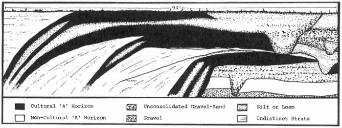
Figure 5.
Stratigraphic profile of native American site near Alamo (Contra Costa County).
In addition to this depositional history, Fredrickson's excavations in an undisturbed portion of the site provided an excellent cultural history. From each cultural stratum, tools implying how vegetation in the locale was used by the succeeding cultures were recovered. The preserved skeletal remains of the faunal species that those groups had exploited were also found.
For a second example of the utility of interdisciplinary study of archaeological research questions, we can turn again to the Lake Miwok Anderson Marsh example. In historic times, the Lake Miwok spoke a language not related to their immediate neighbors, but to languages of groups occupying the San Francisco Bay and Sacramento/San Joaquin Delta areas. Careful linguistic analysis has found the Lake Miwok to be most
[10] Hanchett, Roberta. 1980. Anderson Marsh; preserve or develop? Clear Lake Observer, June 5, 1980.
closely related to the Miwok of the Marin (County) coast and that the languages of those two groups split at about the same time-depth as the romance languages, around 2,000 years ago (fig. 6).
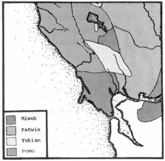
Figure 6.
Native American language groups of north San Francisco Bay.
Archaeological analysis has supported the linguistic hypothesis and added the further dimension that the Miwok movement was probably from the south to the north (Fredrickson 1973). The Lake Miwok arrival apparently displaced a semisedentary hunting and collecting culture, and, while adopting some of the earlier traits, the Lake Miwok brought in a radically different technology and social organization. These data have raised research questions that can only be answered by examinations of interest to both the archaeologist and riparian systems researcher.
Apparently, in the bay and delta areas the Miwok had developed adaptations for living along the shores of a large body of water. There is an obvious difference between bayshore and lacustrine (lakeshore) biotic communities. However, it may have been the traditional technology and labor roles of the Miwok that influenced their settlement in riparian communities. One potential indicator of the Lake Miwok carrying on their old bayshore traditions in the new environment is the abundance of freshwater mussel (Anadonta spp.) in some of their early Clear Lake sites (White and Fredrickson 1981). Sites of the early Miwok along the bayshore are characterized by heaps of mussel (Mytilus spp.) and clam (Macoma spp.) dietary debris, while pre-Miwok sites at Clear Lake have not evidenced an importance of freshwater shellfish in the diet.
One of the dramatic differences between Lake and Coast Miwok sites is the much greater inventory of terrestrial-faunal dietary debris present in the Lake-area sites, so some adjustments to the new environment must have taken place in the Lake Miwok culture. Future study of these adjustments may find that entering the new area put strains upon not only the Lake Miwok, by way of new sources of energy and different organizations of labor, but upon the environment as well, because initial Miwok adaptation probably was not in a tradition balanced with local ecology. We might expect that during the period just after arrival, a special strain would be placed upon those species in riparian systems that were identical or similar to traditional sources of food along the coast, simply because the number of traditional foods in the new area was limited and ways of procuring and processing new foods had to be learned. Thus, for example, the early Lake Miwok use of freshwater clams might have made substantial inroads upon the population and ecology of that species, especially since the previous Clear Lake cultures apparently did not make any significant use of the clam in their diet.
These questions about Lake Miwok prehistory cannot be answered without detailed reconstruction of the paleo-environment and, particularly, the early riparian environments. Individuals from Sonoma State University will be conducting an excavation on an early Lake Miwok site in the Anderson Marsh area in the summer of 1982. The plan is to to use not only the available data for early Clear Lake environments (Adam 1979; Casteel etal . 1977), but to obtain one or two pollen cores from Anderson Marsh. It is hoped that this research will provide the detail needed to understand a single period about 2,000 years ago. In addition, the faunal and floral fossil content of the site (which is adjacent to Cache Creek) will be examined in detail. Even if this investigation sheds no light upon Lake Miwok prehistory, it should result in some findings of interest to riparian systems research.
Conclusion
Cultural resources are non-renewable; once destroyed they are irreplaceable. They provide data on an extensive stretch of time and are the primary sources of information about the people who lived in California before the arrival of Europeans. The threat to their preservation and the preservation of their environmental context is imminent.
When any development or preservation plans are formulated, the presence of cultural resources should be considered. Information on archaeological sensitivity is available to developers and researchers; this information should be utilized to prevent costly holdups or adjustments in development and to aid in the management of California's natural systems.
Literature Cited
Adam, Dave. 1979. Raw pollen counts from core 4, Clear Lake, Lake County, California. USDI Geological Survey open file report 79-663, Menlo Park, Calif. 7 p.
Barrett, S.A. 1908. The entho-geography of the Pomo and neighboring Indians. University of California Publications in American Archaeology and Ethnology 6(1). 332 p.
Callaghan, Catherine. 1978. Lake Miwok. p. 264–273. In : W. Steurtevant and R. Heizer (ed.). Handbook of North American Indians. Vol. 8: California. 800 p. Smithsonian Institution, Washington, D.C.
Casteel, Richard W., David P. Adam, and Joan D. Sims. 1977. Late-Pleistocene and Holocene remains of HysterocarpusTraski (tule perch) from Clear Lake, California, and inferred Holocene temperature fluctuations. Quarternary Research 7:133–143.
Fredrickson, David A. 1966. CCO-308: The archaeology of a middle horizon site in interior Contra Costa County, California. Unpublished M.A. Thesis, University of California, Davis. 202 p.
Fredrickson, David A. 1973. Early cultures of the North Coast Ranges, California. Unpublished Ph.D. Thesis. University of California, Davis. 277 p.
Fredrickson, David A. and John Parker. 1977. An archaeological survey of the Cache Creek basin project, Lake County, Calif. Report S-586, on file at the Northwest Information Center of the California Archaeological Inventory, California State University, Sonoma, Rohnert Park, Calif. 45 p.
King, Thomas, Michael Moratto, and Nelson Leonard III. 1973. Recommended procedures for archaeological impact evaluation. Report on a study by the Society for California Archaeology in cooperation with the Archaeology Survey, University of California, Los Angeles. 19 p.
Kroeber, A.L. 1925. Handbook of the Indians of California. Bureau of American Ethnology, Bulletin No. 78, Smithsonian Institution, Washington, D.C. 995 p.
Lewis, Henry. 1973. Patterns of Indian burning in California ecology and ethnohistory. Ballena Press Anthropological Papers, No. 1. 101 p. Ballena Press, Ramona, Calif.
Mikkelsen, Pat. 1980. Archaeological sensitivity study of the North Sonoma Valley. North Sonoma Valley Specific Plan. 137 p. Sonoma County Department of Planning, Sonoma, Calif.
Peri, David, and Scott Patterson. 1976. The basket is in the roots, that's where it begins. Journal of California 3(2):17–32.
White, Greg, and David A. Fredrickson. 1981. Archaeological investigation at CA-LAK-510, near Lower Lake, Lake County, California. Report S-2166 on file at the Northwest Information Center of the California Archaeological Inventory, California State University, Sonoma, Rohnert Park, Calif. 148 p.