Project Summary
Proposals for development and enhancement at Orestimba Creek fully utilize the excellent potentials that exist there. Perhaps the most important aspect of the plan is the conversion of the existing intermittent creek into a stream with year-round flow. This would be accomplished by gravity releases of water into the creek from the California Aqueduct at the upstream end of the site. The releases would be made during summer months when the creek is normally dry. They would be carefully planned and controlled to enhance the 2.4-km. downstream site for both recreation and wildlife without causing erosion or other problems. The amount of water released would be determined by the flow required to flush and maintain adequate water quality in a swimming pond to be excavated in the creekbed. The flow would also link a chain of fishing ponds created along the stream by carefully deepening and widening the existing channel at appropriate locations. Excess water would pond in the marshy basin at the downstream end of the site.
On a long-term basis, the summer water releases would modify the existing riparian environment. Some of these changes would be beneficial, but others may be less desirable. Because of this, an important part of the proposed project is a management plan to control and direct changes that would occur. A major concept of operation and management at the site is to limit recreational use to a level that would assure long-term conservation of this remnant riparian environment. Entry control, limitation of parking and other facilities, and appropriate supervision of on-site activities are three important parts of productive management that would assure conservation.
Both the creekbed and the marsh would be modified to improve habitat for a year-round fishery. In addition to deepening and widening exist-
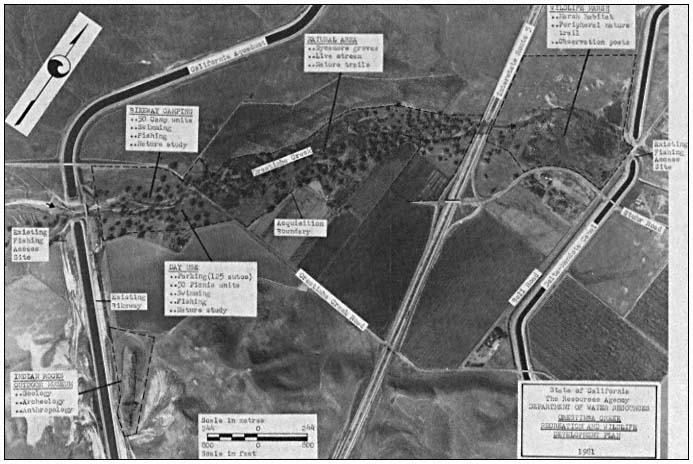
Figure 2.
Orestimba Creek recreation and wildlife development plan.
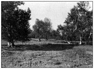
Figure 3.
California sycamores on Orestimba Creek floodplain. Note
absence of ground-and shrubcover and sycamore reproduction
due to cattle grazing. (Photograph by R.E. Warner.)
ing pools, this modification would include a carefully managed planting program to establish new plant species that would provide shade and escape cover beneficial to fish reproduction. The planting program would also add new species to provide additional food and cover for wildlife. Planners hope this will attract new animals which have a greater tolerance for coexistence with people to the site, to replace those species that leave when initial development and public recreation use begins.
In conjunction with the year-round stream concept, the following facilities are proposed as part of the plan for Orestimba Creek (see fig. 2 for specific locations).
A day-use area would be carefully constructed under the canopy of an existing sycamore grove. The area would provide access to an instream swimming pond, a picnic area, the chain of fishing pools along the creek, and a streamside hiking trail linking the upstream and downstream ends of the site.
A small wayside camping area for cyclists using the California Aqueduct Bikeway would be located adjacent to the day-use area, but on the opposite side of the creek. The two areas would share basic facilities and be linked by a pedestrian bridge across the creek.
An outdoor museum is proposed at the Indian Rocks site to display for public viewing the historical and archeological significance of the area. The museum would emphasize the area's importance as a campsite of early nomadic Indian tribes of San Joaquin Valley. An appropriate access trail would be provided.
A shoreline interpretive trail would be constructed around the periphery of the downstream marsh, with observation posts to point out important natural features. This interpretive trail would be linked to the creekside hiking trail extending the length of the site.
The remainder of the riparian environment within the project area, including most of the existing sycamores, would remain in its present undisturbed condition. The plan would not deplete or infringe upon agricutural production in the surrounding area. The only land taken for recreation development and wildlife enhancement would be the rocky bed of the creek, the marshy downstream basin, and the outcrop at Indian Rocks. The project could result in a net increase in productive land if the State can trade its adjacent landholdings with agricultural potential for some of the property required to implement the plan.