Planning Recreation Development and Wildlife Enhancement in a Riparian Environment at Orestimba Creek[1]
Robert H. Morris[2]
Abstract.—This paper summarizes the proposed project for wildlife enhancement and recreation development at Orestimba Creek (Stanislaus County) and discusses problems involved. Some of the problems are especially important because they are common in other riparian environments where public recreation is proposed. This paper deals more with questions than answers. However, an examination of problems is an important phase of productive management of riparian systems.
Introduction
The proposed recreational development and wildlife enhancement project at Orestimba Creek is a reflection of the concern the California Department of Water Resources (DWR) has for restoration and management of our remaining riparian resources. It is justified by the DWR's legal requirement to include planning for recreation and wildlife habitat enhancement in all appropriate activities involving construction and operation of the State Water Project. The remnant riparian environment at Orestimba Creek, located adjacent to the California Aqueduct, makes it an ideal site for such planning.
This paper is based on a critical examination of some of the problems involved in the project. This does not mean the writer is not in favor of the proposal. On the contrary, the proposed plan could be an effective method of conserving and managing the remaining riparian resources at the creek—if development and operation are carefully implemented. The critical approach is taken to emphasize problems that are pertinent to management of California's riparian systems.
Description of the Site
Orestimba Creek is an intermittent stream which flows eastward into the San Joaquin River, draining the Diablo Range of the Coast Ranges. In an average year, flow in the creek occurs only during the winter and spring, mostly from January through April. Except for runoff from adjacent irrigated orchards, the creek is dry for the rest of the year. However, the presence of large sycamores (Platanusracemosa ) (fig. 1) attests to the perennial presence of abundant near-surface water.
The project site is located on a 2.4-km. (1.5-mi.) length of the creek in the western part of the San Joaquin Valley in Stanislaus County. The upstream and downstream limits of the site are defined by the California Aqueduct and the Delta-Mendota Canal, respectively. Both the aqueduct and the canal are siphoned under the bed of the creek to allow the stream to maintain its natural flow. Interstate 5 crosses the creek about 0.8 km. (0.5 mi.) upstream from the Delta-Mendota siphon.
A marshy basin with excellent potential for enhancement as wildlife habitat has formed at the downstream end of the project. Many kinds of wildlife are present throughout the year, both along the creek and in the marsh. Some of these are deer, rabbits, squirrels, ducks, pheasants, herons, quail, doves, and a large variety of smaller birds. Indian Rocks is an additional important amenity. It is a sedimentary outcrop located less than 0.8 km. (0.5 mi.) south of the upstream end of the project area (fig. 2). The site has historical value as a wayside camping area used by early Indian tribes in the valley (Napton 1980).
The part of Orestimba Creek involved in this project is an excellent example of one of California's remnant riparian environments. In addition to a lush growth of other riparian plant species, there are over 300 native sycamores clustered within the limits of the site (fig. 1). These
[1] Paper presented at the California Riparian Systems Conference. [University of California, Davis, September 17–19, 1981].
[2] Robert H. Morris is Recreation Planner, California Department of Water Resources, Sacramento.
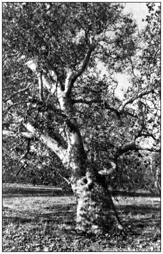
Figure l.
Large California sycamore on the floodplain of
Orestimba Creek. (Photograph by R.E. Warner.)
are among the finest specimens of the species remaining in the San Joaquin Valley. Surrounded by orchards, plowed fields, angular water canals, and concrete traffic lanes, the site stands out like an oasis from the past, a remnant of another time. Although the valley surrounding it has changed, the appearance of this short length of creekbed with its sycamores (many dating back hundreds of years) is quite similar to that when the Miume Yokuts used it as a wayside resting area that provided shade and relief from the scorching summer heat of the valley. The principal difference today is the lack of ground- and shrubcover, and the absence of young trees, because of long-term cattle grazing in the riparian zone (fig. 3).
The riparian site at Orestimba Creek with its magnificent sycamores has excellent potential for recreation development and wildlife enhancement. The 2.4-km length of creek has gently sloping banks that are ideal for installing recreation facilities with minimum disturbance to existing topography. Indian Rocks at the upstream end of the site is within easy hiking distance of the creek. An intensive investigation by the Institute of Archeological Research, California State College, Stanislaus, indicated these attractive geological features have good potential for development as an outdoor museum displaying the important historical and archeological significance of the area. The marshy basin at the downstream end of the project area has fine potential for enhancement as wildlife habitat. This could include a program for public observation and nature study. The adjacent bikeway along the California Aqueduct would provide easy access to and from the creek. No other location along the 113-km. (70-mi.) length of bikeway provides access to a creekside environment like the one at Orestimba Creek. Finally, Interstate 5 and other existing roads provide excellent access for public recreation use.
Project Summary
Proposals for development and enhancement at Orestimba Creek fully utilize the excellent potentials that exist there. Perhaps the most important aspect of the plan is the conversion of the existing intermittent creek into a stream with year-round flow. This would be accomplished by gravity releases of water into the creek from the California Aqueduct at the upstream end of the site. The releases would be made during summer months when the creek is normally dry. They would be carefully planned and controlled to enhance the 2.4-km. downstream site for both recreation and wildlife without causing erosion or other problems. The amount of water released would be determined by the flow required to flush and maintain adequate water quality in a swimming pond to be excavated in the creekbed. The flow would also link a chain of fishing ponds created along the stream by carefully deepening and widening the existing channel at appropriate locations. Excess water would pond in the marshy basin at the downstream end of the site.
On a long-term basis, the summer water releases would modify the existing riparian environment. Some of these changes would be beneficial, but others may be less desirable. Because of this, an important part of the proposed project is a management plan to control and direct changes that would occur. A major concept of operation and management at the site is to limit recreational use to a level that would assure long-term conservation of this remnant riparian environment. Entry control, limitation of parking and other facilities, and appropriate supervision of on-site activities are three important parts of productive management that would assure conservation.
Both the creekbed and the marsh would be modified to improve habitat for a year-round fishery. In addition to deepening and widening exist-
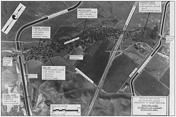
Figure 2.
Orestimba Creek recreation and wildlife development plan.
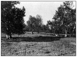
Figure 3.
California sycamores on Orestimba Creek floodplain. Note
absence of ground-and shrubcover and sycamore reproduction
due to cattle grazing. (Photograph by R.E. Warner.)
ing pools, this modification would include a carefully managed planting program to establish new plant species that would provide shade and escape cover beneficial to fish reproduction. The planting program would also add new species to provide additional food and cover for wildlife. Planners hope this will attract new animals which have a greater tolerance for coexistence with people to the site, to replace those species that leave when initial development and public recreation use begins.
In conjunction with the year-round stream concept, the following facilities are proposed as part of the plan for Orestimba Creek (see fig. 2 for specific locations).
A day-use area would be carefully constructed under the canopy of an existing sycamore grove. The area would provide access to an instream swimming pond, a picnic area, the chain of fishing pools along the creek, and a streamside hiking trail linking the upstream and downstream ends of the site.
A small wayside camping area for cyclists using the California Aqueduct Bikeway would be located adjacent to the day-use area, but on the opposite side of the creek. The two areas would share basic facilities and be linked by a pedestrian bridge across the creek.
An outdoor museum is proposed at the Indian Rocks site to display for public viewing the historical and archeological significance of the area. The museum would emphasize the area's importance as a campsite of early nomadic Indian tribes of San Joaquin Valley. An appropriate access trail would be provided.
A shoreline interpretive trail would be constructed around the periphery of the downstream marsh, with observation posts to point out important natural features. This interpretive trail would be linked to the creekside hiking trail extending the length of the site.
The remainder of the riparian environment within the project area, including most of the existing sycamores, would remain in its present undisturbed condition. The plan would not deplete or infringe upon agricutural production in the surrounding area. The only land taken for recreation development and wildlife enhancement would be the rocky bed of the creek, the marshy downstream basin, and the outcrop at Indian Rocks. The project could result in a net increase in productive land if the State can trade its adjacent landholdings with agricultural potential for some of the property required to implement the plan.
Is Public or Private Ownership Best?
Anyone with a sincere concern for future conservation of the riparian environment at Orestimba Creek must consider the relative merits of public and private ownership. Is it in the best long-term interests of the site to remove it from private ownership? Will government ownership proposing public use and more productive management provide better assurances for future preservation? To answer these questions, the nature of existing private ownership must be considered.
Three landowners are involved. The first is a local family whose ancestors came to the valley as pioneers many years ago. The family has strong ties to the land and a sincere interest in retaining ownership and preserving the site. They have owned their part of the creekbed for as long as anyone can remember, and they maintain a "barbwire" stewardship that has effectively protected the remnant riparian land by excluding all public access. Although there has been no "productive management" to enhance the creekbed, there can be no doubt that many of the sycamores and much of the other riparian vegetation has survived only because of the protection provided by this private ownership. The family is against any proposal to take the land for public use.
The second landowner does not date back to pioneer days, but he also has held his land at the creek for many years. His interests are more commercially oriented. He owns and manages extensive orchard developments along the north and south sides of the creekbed. To protect his orchards, this owner practices the same land stewardship that excludes all public access. Although his motives are different, the results have been the same. The riparian system has survived because of the effective protection provided by the existing private ownership. This landowner is also against the plan to take his holdings at the creek for public use, even though none of his orchard property would be involved.
The third owner is very different. It is a nonresident corporation; the property along the creek is a recent acquisition. The corporation proposes major new commercial developments that include facilities for travelers using Interstate 5. If these plans are implemented, they will attract large numbers of people to the area adjacent to the creek. The corporation is in favor of the plan to open the site for public recreation, primarily because the owners believe it will positively affect their proposed developments. They are willing to sell their part of the creekbed needed by the State if they can benefit by the sale. They do not believe their proposed traveler facilities will have any adverse effects on survival of the adjacent riparian environment of Orestimba Creek.
Approximately 80% of all riparian systems in our country are presently in private ownership and have not been subjected to governmental management (Warner 1979). The remnant site at Orestimba Creek is part of this 80%. Although the land surrounding it has been changed substantially for agricultural uses, the creekbed has remained relatively unchanged. It has survived primarily because of its lack of value for development and the exclusion of the public by private owners. In consideration of this, is it in the long-term interest of the site to substitute governmental management which proposes public use?
New corporate ownership at the creek proposes changes that may threaten the survival of the adjacent riparian system. On the other hand, the limited funds available may not assure appropriate governmental operation to control public uses. We are all familiar with the damage that an unsupervised public can inflict on a fragile riparian environment like the one at Orestimba Creek. Public ownership may be the best way to go, but only if governmental management can assure that this remnant site has at least as much protection in the future as it has had in the past under private stewardship.
Are Public Recreation and Wildlife Preservation Compatible?
Riparian systems are as attractive and useful to people as they are to dependent fish and
wildlife populations (ibid .). This is surely true for the section of Orestimba Creek involved in the proposed plan. As indicated, the site is located adjacent to the California Aqueduct and has excellent potentials for both recreation development and wildlife enhancement. However, the question of compatibility must be considered. Is it logical to assume that these two uses can occur simultaneously at a small, fragile site such as Orestimba Creek?
Remnant riparian environments often constitute the only available roosting, nesting, and escape habitat for many wildlife species (ibid .). This is undoubtedly the case at Orestimba Creek. As the surrounding valley has been modified for agricultural production, the creek and adjacent riparian system have become an escape site for many indigenous species that at one time were present in much greater numbers. Most (if not all) of these remaining animals have definite territorial needs that must be met. In consideration of this, is it good planning to infringe on this remaining sanctuary by trying to combine public recreation use and wildlife enhancement at the same small location?
The summer water releases from the Aqueduct will significantly improve the riparian environment along the creek and in the downstream marsh. This, in conjunction with the planting program to provide additional food and cover resources, should attract new species to the site. However, is it reasonable from a biological point of view to assume most of these animals will be able to adjust their territorial needs to coexist with people in a public recreation setting? At a larger site with adequate room for separation and buffers, the two conflicting uses could probably be managed effectively. Space restrictions at Orestimba Creek may be the limiting factor that will preclude long-term survival for many of the remaining wildlife species in the presence of recreational development.
If the proposed plan, including effective management and operation, is carefully implemented, the creek site can be enhanced for both recreation and wildlife. Limiting public use and maintaining on-site control are two important parts of effective operation. They are necessary if the riparian system is to remain a viable environment for most species. Changes will inevitably occur—to the detriment of some species and the advantage of others—but long-term preservation can be reasonably assured. This preservation will probably involve compromises for recreation and/or wildlife.
Does Existing Environmental Law Provide Adequate Protection?
It is probably safe to assume that most people involved with the issue generally agree that existing environmental laws (National Environmental Policy Act and California Environmental Quality Act) provide important protections for the conservation and management of our remaining riparian systems. The environmental investigation and analysis required under these laws assure consideration of significant impacts and long-term preservation. This is especially important because in America over the last 150 years, between 70% and 90% of indigenous riparian resources have been destroyed (ibid .). Adequate legal protections must be provided if the remaining riparian environment is to survive. However, if we take a closer look at specific ways in which environmental laws are interpreted and applied, some serious doubts arise concerning their adequacy. The project described in this paper provides one example of contradictions that can occur.
The plan to develop recreation and enhance wildlife at Orestimba Creek requires completion of a full environmental impact report (EIR) before any final decision for the project can be made. The EIR must evaluate all significant impacts of the proposal and consider mitigation measures and alternatives to the project to minimize adverse impacts. A draft of the report must be available for review by all interested parties, and comments received from reviewers must be given adequate consideration. These are all requirements under the California Environmental Quality Act, and they provide important protections for the remnant riparian site at the creek. This is an example of an appropriate application of the law.
Another recent activity at the Orestimba Creek site presents a different interpretation of the law. A gravel extraction operation just a few hundred feet upstream from the proposed project has been in process for some time and has already produced significant adverse impacts. A large area of the creekbed has been graded clean to excavate gravel material. This has removed protective vegetative cover important in reducing erosion damage during winter floodflows. In addition, a temporary road was constructed across the creek to provide access for gravel trucks. The loose material used to construct the crossing will produce a substantial increase in downstream siltation during winter flows. If the gravel operation continues, it will create serious erosion and siltation problems for downstream recreation use and wildlife enhancement. Even without the proposed project, gravel removal will adversely affect the existing downstream riparian site.
Considering these obvious impacts that surely could have been predicted, why and by what authority was this type of commercial activity permitted? In apparent compliance with the provisions of the California Environmental Quality Act, Stanislaus County officials reviewed the project and granted it full environmental clearance under a Negative Declaration that states the activity will not have significant effect on the environment at the creek. Mitigation measures were not made a condition of the approval, and apparently the extraction operation will be permitted to continue as long as it is economically feasible.
This contradictory application of environmental law raises doubts about is efficacy for preserving at least some of our remaining riparian resources. Based on individual interpretation, the legal "protection" represents a two-edged sword. Those of us concerned with preserving what we have left must be vigilant in our efforts to assure that the cut is for, not against, our cause.
Who Will Pay for Conserving and Managing Our Remaining Riparian Resources?
The Orestimba Creek project involves another problem pertinent to management of riparian systems. The proposed site has excellent potentials for recreation use and wildlife enhancement. It is equally important that the remaining riparian system be conserved and managed effectively, but who will assume responsibility for doing the work and where will the required funds come from? Despite its excellent potentials, there is significant doubt that a capable operator with adequate funds will be found to develop and operate the proposed creekside site.
Conservation and productive management of our remaining riparian resources must involve a coordinated multi-agency approach that includes federal, state, county, municipal, and private owner stewardship (ibid .). This is the most effective approach to the problem. However, considering the financial bind that governmental and private agencies are facing (with the compounding effects of rising costs and declining revenues), is it reasonable to expect that large sums of money will be available to do the work required? With the recent cutbacks in many vital services, is it logical that governmental agencies at any level will give a riparian resources program high priority when allocating limited funds? If government participation will be difficult to obtain, is it any more reasonable to expect private ownership, faced with the same revenue and inflationary problems, to invest large sums of money in conserving and managing riparian land when there will be no dollar profit obtained from the investment?
Answers to these questions must be realistically considered before we begin to develop a program to preserve our remaining riparian resources. No matter how valid our motivations, our programs will be meaningless if adequate funding is not available for implementation. This is true for the Orestimba Creek project specifically and other proposals to preserve riparian systems in general.
Literature Cited
Napton, L. K. 1980. Cultural investigations of the proposed Orestimba Creek wayside park, Stanislaus County, California. 142 p. California State College, Stanislaus, Institute of Archeological Research, Department of Anthropology, Turlock, Calif.
Warner, R.E. 1979. The California riparian study program. 177 p. Planning Branch, California Department of Fish and Game, Sacramento.