Management of Riparian Ecosystems
Resource management problems encountered in riparian ecosystems are due to a number of onand off-site impacts. Off-site impacts are generally the more serious and less controllable of the two. Critical off-site impacts include watershed and hydrologic disturbances such as logging, stream or lake modification (dams, channelization and controlled flow), wildfire, urbanization, off-road vehicular activity, and cultivation.
Off-Site Impacts
The most tragic and dramatic example of offsite impacts is the ongoing destruction of the Bull Creek watershed within Humboldt Redwoods State Park, Humboldt County. At the confluence of Bull Creek and the South Fork of the Eel River is one of the most magnificent stands of coast redwoods in the world—the 3,640-ha. (9,000-ac.) Rockefeller Forest. Prior to the recent discovery of a tree slightly taller in the Redwood Creek watershed the world's tallest tree was thought to be in this pristine grove. In the first part of this century the grove was purchased by DPR with funding provided by private sources (John D. Rockefeller). Meanwhile, logging was occurring in the upper watershed. The entire watershed, with the exception of the state park property, was clear-cut and the slash burned.
The winter of 1955–56 brought heavy rains and flooding to northern California; severe erosion and stream channel destruction resulted. The riparian alder and willow thickets along the stream channel were completely washed out, and the magnificent riparian redwood giant forests of the alluvial flats were undercut; numerous ancient trees toppled into the stream, clogging the channel, which caused further undercutting. The stream channel area was completely devastated, quadrupling in size. The 1964 floods further widened the channel (fig. 3).
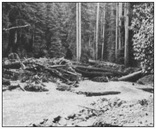
Figure 3.
Bull Creek "shoofly" in Humboldt Redwoods
State Park, February 1965.
DPR began a massive cleanup, erosion control, and stream channelization project. The channel was riprapped and a long-term resource protection program was initiated which included various types of research (fig. 4). Volunteers replanted trees in the watershed and riprapped banks were revegetated with riparian species (willows and alders stuck or planted between the rocks). To date more than $2.28 million has been spent on the Bull Creek Project.
We are now beginning to look at similar, although less critical, riparian forest losses along the South Fork of the Eel River; however, the upper Bull Creek watershed is still unstable, with massive slides occurring each winter (fig. 5). No feasible solution to these slides has been suggested.
Channelization of the Sacramento River has caused serious bank erosion problems in Woodson Bridge State Recreation Area. The stream channel is undercutting streamside riparian vegetation and has cut through the levee. The channel upstream has been riprapped in such a way that the current is directed into an unriprapped bend within the unit. Further, if this bank is riprapped to protect the valley oak riparian woodland, the current will be deflected to the opposite bank where a fine cottonwood riparian forest is located in Woodson Bridge Natural Preserve. The preserve is a nesting area for the rare Yellow-billed Cuckoo. Various bank protection measures are currently being investigated.
Wildfire has caused numerous types of damage to streamside riparian ecosystems. The combination of an extremely hot wildfire (the Molera Fire of August 1972) and heavy rainfall caused mudflows in the Big Sur River watershed (Cleveland 1973). Between mid-October 1972 and mid-February 1973, mudflows were generated by heavy and occasionally intense winter rains falling on steep, fire-denuded slopes of the Santa Lucia Range. Damage from mudflows and floodwater was predominantly confined to riparian zones along the lower courses of Pheneger, Juan-Higuera, and Pfeiffer-Redwood creeks. Although extensive damage occurred to property and to the coast redwood riparian forests, investigations of coast redwood root systems have shown mudflows to be a recurring natural phenomenon (fig. 6). Thus, from an ecosystem management standpoint no action would be taken; however, burned-over watersheds
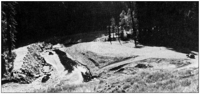
Figure 4.
Riprap in Bull Creek, Humboldt Redwoods State Park, October 1971.
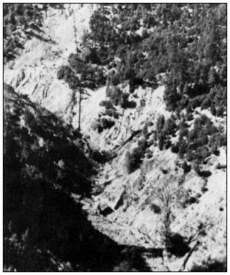
Figure 5.
Slide area in the upper Bull Creek watershed,
Humboldt Redwoods State Park, October 1971.
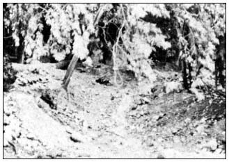
Figure 6.
Mudflow material in Pfeiffer-Redwood Creek,
Pfeiffer Big Sur State Park, January 1973.
were reseeded and gabions installed in the Big Sur River to try to protect the town of Big Sur, where extensive damage occurred.
Wildfire followed by flash flooding has caused obliteration of desert riparian ecosystems (fig. 7).
Among California's coastal dune systems are fine riparian ecosystems located in moist-dune swales and adjacent to dune-formed lakes. These micro-ecosystems are characteristically dominated by willow thickets in dune swales and alder thickets along lake banks.
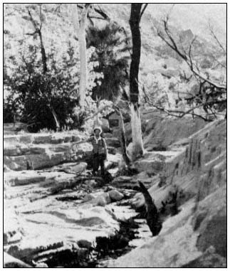
Figure 7.
Sedimentation and erosion in Hell Hole Canyon,
Anza-Borrego Desert State Park, San Diego County,
following wildfire and flash flood, April 1978.
The Ten-Mile River dune system is located in MacKerricher State Park (Mendocino County). Prior to acquisition, the dune system was open to off-road vehicles. Also, by the turn of the century most of the Ten-Mile River had been logged. With the heavy erosion that followed, through the process of littoral drift, sediments from the watershed caused a great increase in sand supply to the dune system. In the 1920s, Highway 1 was inundated with sand and had to be realigned. By the 1950s the dunes were in a relatively stable condition. Off-road vehicles gradually became popular, however, and by the 1970s a great deal of off-road vehicle use and renewed dune movement was evident. Numerous riparian swales were inundated. In some cases the willows were able to grow faster than they were being covered with were being covered with sand, eventually ending up on dune crests and helping halt the inward movement of sand (fig. 8). DPR is currently conducting studies of the impact of off-road vehicles on the dune system and methods to restore the fragile dune vegetation. Of special interest is the unique riparian ecosystem adjacent to Sand Hill Lake. This fen-carr ecosystem is the only one of its kind known in California (Barry and Schlinger 1977).
The most critical off-road vehicular impacts occur at Pismo Dunes State Vehicular Recreation Area, San Luis Obispo County. Here, extremely heavy use has destroyed hundreds of acres of dune vegetation.
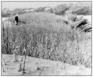
Figure 8.
Willow riparian area being inundated by active
dunes, Ten-Mile Dunes, MacKerricher State Park.
As a result, most swale riparian ecosystems have been covered up within the first 1.6 to 2.4 km. (1 to 1.5 mi.) of the beach. Oso Flaco Lake, which is surrounded by riparian vegetation and numerous rare endemic, endangered, or otherwise threatened species, is slowly being inundated with sand. A massive dune revegetation program has just been initiated to the windward side of the lake. Revegetation is to be with native dune vegetation; seed collections and cutting stock are being taken from within the dune system. Remaining examples of dune plant communities are being described, mapped, and analyzed through a series of permanent plots. Fencing will be installed to keep vehicles out of the windward dunes. Although DPR plans to spend $160,000 per year on this restoration project, it may be too late to save this unique dune lakes area, which separates the dune system from the rich agricultural lands to the east.
On-Site Impacts
On-site impacts to riparian ecosystems encountered in the State Park System include livestock grazing, cultivation, exotic species invasion, off-road vehicle damage, equestrian trampling, and human trampling, roughly in that order of importance.
With the recent passage of SB 2469,[11] the otherwise inviolate natural resource of the State Park System[12] now may be leased for agriculture purposes. It has long been known that cultivation, grazing, and the interruption of natural flooding and fire cycles have threatened the existence of the magnificent valley oak savannas, woodlands, and forests of California.
[11] Section 5069 PRC.
[12] Section 5001.65 PRC.
More subtle but just as critical is the impact of grazing on the understory of riparian communities. Native grasses and palatable native forbs are eliminated and replaced by thistles and other alien weedy species. A once very widespread riparian native understory grass, blue wildrye (Elymusglaucus ), has all but been eliminated from these ecosystems. Relict stands of blue wildrye occur associated with valley oak and cottonwood communities on the floor of Yosemite Valley (Tuolumne and Mariposa Counties), in Hungry Valley State Vehicular Recreation Area (Ventura County), and Malibu Creek State Park (Los Angeles County). Grazing of riparian ecosystems also affects the water quality of adjacent waterways. Ahjumawi Lava Springs State Park (Shasta County), illustrates this problem. The springs, rivers, ponds, and lakes in and adjacent to this unit show phosphorus and nitrate loading, with algae blooms turning much of the water green. Cattle roam freely in and out of the aquatic wetland and terrestrial ecosystems of the unit (fig. 9).
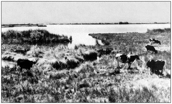
Figure 9.
Cattle grazing in the riparian zone at Ahjumawi Lava Springs State Park. Domestic
grazing animals have become a serious ecosystem management problem.
The invasion of alien species is almost universal in riparian ecosystems. Alien species from the Mediterranean region are common in the understories of riparian communities throughout the state. Blue gum (Eucalyptusglobulus ) and other Eucalyptus species have displaced native riparian vegetation at Mt. Tamalpais (Marin County), Montana de Oro (San Luis Obispo County), and Annadel (Sonoma County) state parks. When resource management programs are planned or initiated to eliminate these alien, low-diversity communities and replace them with native riparian species, considerable local opposition has usually all but stopped the efforts.
At Point Mugu State Park, a prime example of a California sycamore riparian woodland ecosystem occurs (fig. 10). However, over 100 years of grazing has eliminated of most native herbs in the understory. The understory is made up largely of milk thistle (Silybummarianum ), an alien species which needs disturbance of the soil surface for germination and soil compaction to compete with native species; both factors are provided by the hooves of domestic livestock. To date, a control method for milk thistle has not been found, but biological control methods are being investigated.
In Anza-Borrego Desert State Park many native riparian ecosystems are being invaded by salt cedar (Tamarix gallica ), an alien species of Euroasia which not only is out-competing native riparian species, but is also causing springs which the desert big horn sheep and other wildlife rely on for summer and fall water supply to dry up. The problem concerns the California Department of Fish and Game (DFG) as well as DPR. To date, no method has been found to eradicate salt cedar. The problem has been investigated by the National Park Service (NPS) with no satisfactory results. The answer will likely be found in the natural habitat of salt cedar. Somewhere in Eurasia a biological control may exist.
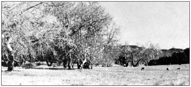
Figure 10.
California sycamore riparian woodland in Point Mugu State Park being grazed.
Most native understory herbs have been replaced by alien weeds.
The off- and on-site impacts of off-road vehicles at Pismo State Vehicular Recreation area have been covered. Severe on-site impacts due to off-road vehicles are well illustrated at Hungry Valley State Vehicular Recreation Area (fig. 11), Anza-Borrego Desert State Park, and Red Rock Canyon State Park (Kern County).
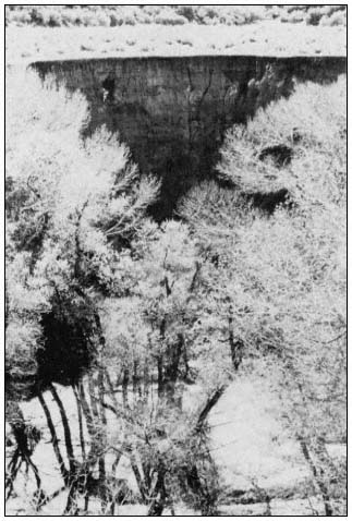
Figure 11.
Sedimentation in riparian woodland, Canada de Los Alamos,
Hungry Valley State Vehicular Recreation Area. Off-road
vehicle use upstream is causing siltation.
Only Hungry Valley State Vehicular Recreation Area will be covered here. The understory of a Fremont cottonwood riparian forest has been about 90% destroyed in the informal staging and camping area at the northern end of the unit (fig. 12). Unique valley oak woodland and savanna ecosystems are threatened with similar devastation. The understory of the valley oak woodland here contains more native grass species than known from any other area in the state. Here blue wildrye (Elymusglaucus ), deer grass (Muhlenbergiarigins ), purple needle grass (Stipapulchra ), nodding needlegrass (Stipacernua ), and giant squirreltail grass (Sitanionjubatum ) occur along with willows (Salix sp.) and California wild rose (Rosa californica ).
This unique riparian ecosystem, along with the largest and most diverse native grassland ecosystem within the foothills region of the state, was proposed for natural preserve status at the October 1981 State Park and Recreation Commission hearing in Los Angeles. The proposed natural preserve status for the small valley oak woodland has not been opposed by the off-road vehicle special interest group. However, the proposed natural preserve status for a larger, 567-ha. (1,400-ac.) native grassland has met strong opposition; the grassland is likely doomed to offroad vehicular use and ultimate destruction.
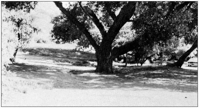
Figure 12.
Off-road vehicular staging area has caused destruction of understory and groundcover in
Fremont cottonwood riparian woodland, Hungry Valley State Vehicular Recreation Area.