The Calapooia Landscape
The Calapooia River, little more than a stream, rises in the western Cascades and tumbles down a narrow, forested canyon in a northwesterly course for about twenty-five miles before flowing out onto the level plains of the lower Calapooia Valley. In its canyon the river winds its way around foothills that rise above the level, narrow valley—not more than a mile wide—for about six miles. One small but important stream, Brush Creek, joins the river before it cascades down a waterfall of less than ten feet in height and enters the wider—up to three miles—lower valley of the Calapooia, still surrounded by foothills reaching fifteen hundred feet in elevation. For another six miles the Calapooia hugs the foothills along the northern wall of its little canyon, and then the river finally flows out onto the floor of the Willamette Valley; trending in a north-northwesterly direction, it winds its way sluggishly through numerous oxbows for thirty-one miles to its confluence with the Willamette. Over this distance it drops only 145 feet, or roughly five feet per mile.
During the winter of 1852–53, six years after permanent settlement began in the Calapooia Valley, federally hired surveyors came to the locale to fix township, range, and section lines. Their detailed notebooks make it possible to reconstruct the early geographic and vegetative landscape of the Calapooia (map 2). The surveyor described the southern wall of the Calapooia as "high broken hills & mountains with numerous deep ravines and rocky ridges timbered principally with fir with a thick und[er]gr[owth] of hazel vine maple wild cherry fern & briars." The hills to the north of the river, with a southern exposure, he reported as drier and less densely forested. They were "covered with scattering" of oak, fir, and pine and produced "a fine quality grass."[5] At the western terminus of the small Calapooia Valley, its prairies mingle with the Willamette's. At this point, the foothills of the Cascade mountains continue to the north until broken by the South Santiam River valley. From the south side of the Calapooia Valley's mouth, foothills, now known as the Coburg Hills, stretch southward in a high, unbroken chain to the McKenzie River.
When settlers first arrived in the Calapooia Valley, its floor, from its eastern extension to its opening onto the Willamette, consisted principally of open prairie with a scattering of ash and oak trees. The ash thrived in thickets and low-lying swales while the oaks grew either as
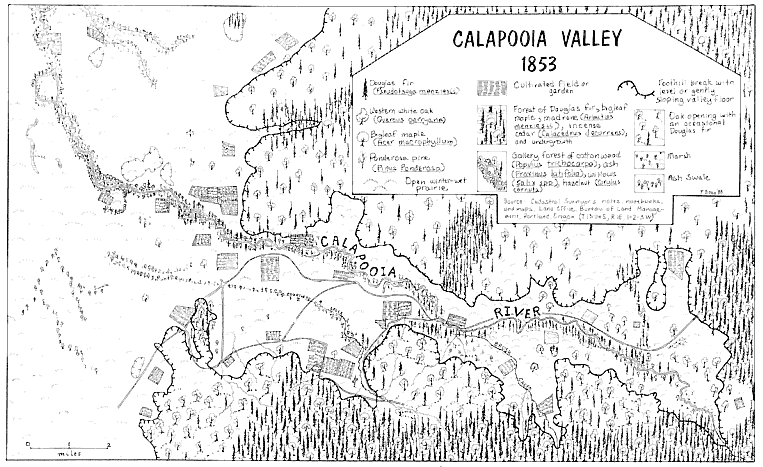
Map 2.
The Calapooia Valley, 1853.
solitary giants on the prairie or in the form of savanna or oak groves. The eastern portion of the Calapooia, through which Brush Creek flows, was more heavily forested with oaks than was the western portion adjoining the Willamette Valley, which the surveyor described as having a "scarcity of timber." The prairies of the Calapooia and adjoining Willamette Valley he noted as "level . . . with a rich soil of clay loam which produces an abundance of superior quality grass. The prairie being nearly level is very wet in the rainy season." Surveyors described lower Brush Creek as either marshy or simply a swamp. Courtney Creek, a slightly smaller brook in the western portion of the Calapooia, typified the valley's "several small streams that head in the mountains but sink on reaching the prairie." Along the Calapooia River, bottomland ranged from one-fourth to one-half mile in width and was "subject to inundation to the depth of 5 or 6 feet & is well timbered with fir maple ash & balm [cottonwood] undgr[owth] hazel vinemaple & briars." The river's characteristics varied from one end of the valley to the other. In the eastern portion it reached only fifty-five links (about thirty-six feet) in width and in the west one hundred links (sixty-six feet). Its current was described as rapid throughout its length in the Calapooia Valley proper.
In 1846 the first Euro-American settlers permanently located at the base of the hills and mountains on the banks of the Calapooia. They did so at a time in American history when, according to the landscape architect John R. Stilgoe, steam, iron, and a developed market economy, as well as new systems of organization inherent in the industrial revolution, were effectively changing the relationship between people and the land in some parts of the country.[6] On the Calapooia, still newly settled and relatively distant from the influences of the industrial revolution, early settlers experienced a time lag of a few years during which they had few intermediaries, such as a developed market economy and industrial systems, to distance them from the land. Rather, during the initial years of contact, settlers related directly to the land and acquired an intimate understanding of its physical configuration and idiosyncrasies as they molded a midwestern and upper southern culture to it. While settlers had to contend with natural catastrophe and components of the landscape that they never could accept, they also, through their daily activities, developed a positive relationship with their new landscape.[7]