The Earthquake/Fault Paradigm
The hypothesis that earthquakes result from faulting developed near the turn of the century (Dutton, 1904; Reid, 1910) and evolved with contributions from many scientific disciplines. Although different communities of earth sci-
entists have different studies of seismogenic faulting as models, and their paradigms accordingly differ somewhat, I would suggest that the basic earthquake/fault paradigm for mapping crustal shocks comprises the following theses: (1) most crustal earthquakes result from the release of tectonic strain energy by sudden shear fracture along preexisting faults; (2) high-quality seismicity data from an active crustal source region will define two-dimensional planar or slightly curved zones of hypocenters, corresponding to faults, and focal mechanisms will have nodal planes parallel to the local orientations of the hypocentral surfaces; and (3) large crustal earthquakes occur on large faults, which therefore may extend from seismogenic depths to the near-surface and be mappable with geologic or geophysical data. The preceding theses are hypotheses and expectations that appear inherent in the ways in which observational seismologists design seismicity studies and in the ways in which they seem most naturally to interpret the resulting hypocenters and focal mechanisms.
A suite of observations that exemplify each of the theses in the basic earthquake/fault paradigm is found in the Parkfield, California, section of the San Andreas fault (fig. 1). Five earthquakes of magnitude about 6 have taken place since 1857 on apparently the same segment of the fault; the coseismic displacement seismologically inferred for each shock appears equal to the displacement that would be expected to accumulate elastically across the fault between shocks (Bakun and McEvilly, 1984). The most recent such shock occurred in 1966; geodetic data are consistent with the segment of fault that ruptured in 1966 being currently locked at depth and accumulating strain (Harris and Segall, 1987). Small and moderate earthquakes occur on a nearly vertical plane beneath the surface trace of the fault and have mechanisms consistent with slip on the fault. The fault zone is conspicuous in regional geology and geomorphology.
In a region in which seismogenic faults are not revealed in seismographic or geologic data as directly as the San Andreas fault is revealed near Parkfield, the earthquake/fault paradigm may be elaborated as in studies of the Coalinga earthquake of 2 May 1983 (fig. 1). Hypocenters and focal mechanisms in the Coalinga region do not define a single plane, and the causative fault of the main shock of 2 May 1983 does not outcrop at the surface. The hypocenters and focal mechanisms are, however, well accounted for in terms of slip on intersecting faults (Eaton, 1985b ). Stein and King (1984) have shown that the seismogenic reverse or thrust faulting that occurred at depth appears to manifest itself as folding in the weak near-surface sedimentary rock. They suggest that, in regions in which surface rock is sedimentary, the presence of reverse faulting at depth may often be found more easily by searching for associated folds rather than outcrops of fault planes. In this case, the apparent failure of the Coalinga earthquake to conform to the third thesis of the earthquake/fault paradigm led to a richer version of the para-
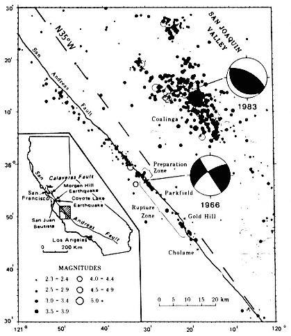
Figure 1
Seismicity of central California in the region of Parkfield and Coalinga
for the period 1975–1984 (from Dewey et al., in press, after Bakun and
Lindh, 1985). Focal mechanisms of the 1966 Parkfield and 1983 Coalinga
earthquakes are shown. N35° W is the direction of pure transform motion
between the Pacific and North American plates.
digm, in which active surface folds are added to active fault traces as possible indicators of potentially dangerous earthquake sources.
The seismicity of central Idaho (fig. 2) provides examples of several phenomena not yet, but probably soon to be, incorporated into the earthquake/fault paradigm. These phenomena are the quiescence of major faults at the small magnitude level for long periods between the generation of large earthquakes, the occurrence of small and moderate earthquakes away from major faults, and the occurrence of aftershocks on faults other than those of the corresponding main shocks.
Central Idaho was the site of the magnitude (Ms ) 7.3 Borah Peak earthquake of 28 October 1983. The cause of that earthquake was slip on a major preexisting fault, the Lost River fault (Crone et al., 1987), most of which had been quiescent down to magnitude 3.5 during the previous two decades (fig. 2). From 1963 until the 1983 Borah Peak main shock, small and moderate earthquakes in central Idaho had occurred most frequently several tens of kilometers west and north of the Borah Peak source. Although aftershocks in the first ten days following the main shock were located close to the coseismic fault surface defined from geologic and geodetic data, later aftershocks occurred in a zone twice as long as the main-shock rupture (fig. 2).
Such observations might be viewed as already accounted for in an extended earthquake/fault paradigm, because they are considered possible outcomes of seismicity studies premised on the seismogenic-fault model. But I am not aware of an independently defined community of users that has reached consensus about the seismotectonic environments in which these phenomena should be considered expected outcomes of seismicity studies.
The phenomenon of fault quiescence is currently being studied using the hypothesis that individual segments of seismogenic faults slip by characteristic amounts in the coseismic phase of each seismic cycle, and that the characteristic displacement and interval between displacements of a given fault segment tend to increase with segment length (Allen, 1968, Sieh, 1978; Schwartz and Coppersmith, 1984). Faults that comprise many segments are most likely to experience frequent small and moderate shocks; faults that comprise a few large segments are most prone to long periods of quiescence separated by large earthquakes. This characteristic-displacement hypothesis would lead to an elaboration of thesis 2 of the earthquake/fault paradigm. Although seismographic recording in active source regions would still be expected to define planar faults, the largest faults in the region might not be revealed in a time period much shorter than the durations of the seismic cycles on the faults. Quiescence at small and moderate magnitudes would be expected in a short period of seismographic monitoring of a fault if geologic studies showed the fault to be geometrically simple with a recent history of large, episodic displacements.
The characteristic-displacement hypothesis also explains the observation
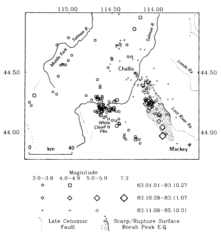
Figure 2
Seismicity of central Idaho in the vicinity of the Borah Peak earthquake of 28 October
1983. Epicenters are distinguished according to whether the shocks occurred before,
within ten days after, or between ten days and two years after the Borah Peak main
shock. Epicenters were computed by Dewey (1987). Borah Peak fault scarps are from
Crone et al. (1987), and the rupture surface is from Ward and Barrientos (1986).
that some large earthquakes are followed by aftershocks near, but not on, the main-shock rupture surface. Stress is effectively relaxed on the simple main-shock source by the occurrence of the main shock, and most of the main-shock surface will not rupture again until sufficient strain energy has accumulated to again produce the characteristic displacement. Aftershocks occur on the margins of the main-shock rupture, due perhaps to slip on smaller branch faults, which must accommodate some of the displacement of the main fault (King, 1983), or to slip on preexisting faults on which effective shear stress has increased as a consequence of main-shock faulting (Chinnery, 1966; Nur and Booker, 1972). Many aftershock studies are conducted on the assumption that aftershock hypocenters are distributed on the surface that slipped in the main shock. Under the characteristic-displacement hypothesis applied to aftershock sequences, the location of aftershocks of a major earthquake would be expected to define fault surfaces secondary to the fault surfaces on which most of the main-shock seismic moment was released.
Small earthquakes occurring kilometers to tens of kilometers away from major regional faults have traditionally been interpreted as due to minor faults slipping under the same regional tectonic stress causing slip on the major faults (Richter, 1958). Substantial elaboration of this interpretation has come with studies showing the wide range of preexisting fault orientations that may be favorable to slip under a given stress field (McKenzie, 1969; Angelier, 1984). It is also commonly accepted that some small earthquakes may reflect local stress fields that are either independent of the regional stress field or second-order consequences of large tectonic displacements induced by the regional stress field. Algorithms have been developed that permit extraction of several significantly different orientations of focal mechanisms from a suite of first motion data for a group of earthquakes (Brillinger et al., 1980) and that enable a search for a single orientation of the tectonic stress field that may be consistent with differently oriented focal mechanisms (Gephart and Forsyth, 1984).
Midplate regions, located far from the belts of earthquakes and late-Cenozoic deformation that define plate boundaries in the earthquake/plate-tectonic paradigm (see next section), pose special problems for the earthquake/fault paradigm. In most midplate areas monitored by regional or local networks of seismographs, the resulting hypocenters and focal mechanisms do not define planes of shear displacement coinciding with mapped crustal faults (for example, see Bollinger and Sibol, 1985; Wetmiller et al., 1984). It is possible that, in some of these areas, midplate earthquakes do not occur on preexisting faults but rather represent fractures of previously intact rock, being thereby natural analogs of some mine rockbursts (Evernden, 1975). In that case, the distribution of microcracks or the rheological properties of the unfractured rock, rather than the presence of geologically mappable faults, might determine the positions of earthquakes (McGarr et al.,
1975). Even if the resulting earthquakes involved the development of faults in previously intact rock, such earthquakes would not fulfill all of the expectations of the earthquake/fault paradigm. Earth scientists would lose one of the most important pratical consequences of the paradigm, that sites of future earthquakes are in principle identifiable by mapping of the faults on which they will occur. The apparent ineffectiveness of the paradigm in many midplate regions may, however, be due to the small sizes of the shocks for which the paradigm is being called upon to account. As just noted, even in areas with well-documented seismogenic faulting in the western United States, it may be difficult to associate many small earthquakes with individual faults. But in the active parts of the western United States, seismologists' confidence in the earthquake/fault paradigm does not depend on its making sense of the small shocks.
An observation that supports the appropriateness of the earthquake/fault paradigm for at least some midplate regions is that late Cenozoic reactivation of pre-Cenozoic faults has been identified at a number of sites in the central and eastern United States (Wentworth and Mergner-Keefer, 1983; Donovan et al., 1983). Most of these faults have been quiescent during the time period in which earthquakes might have been reliably located in their vicinities, but, as noted earlier in this section, quiescence of potentially seismogenic faults is quite commonly observed in regions of high Cenozoic tectonism. The crucial implication of the reactivation is that crustal faults can persist as sites of shear failure in tectonic environments that are far different from the environments in which the faults originally formed.
Results from a multidisciplinary investigation of the Mississippi Embayment seismic zone (fig. 3) have shown the value of the earthquake/fault paradigm in an important midplate seismic region. In addition, the Mississippi Embayment studies must be viewed as justifying the patience-trying accumulation of seismographic, geophysical, and geologic observations to solve a seismotectonic puzzle. The Mississippi Embayment source produced the New Madrid earthquakes of 1811 and 1812, the largest in the history of the central and eastern United States. The status of our knowledge of the distribution of earthquake epicenters in the Mississippi Embayment prior to mid-1974 is shown in the left panel of figure 3; the distribution does not suggest the presence of faults. In mid-1974, Saint Louis University installed a regional network in the Mississippi Embayment region (Stauder et al., 1976). This network greatly increased the number and accuracy of earthquake hypocenters in the Mississippi Embayment (right panel, fig. 3); the 1975–1985 data also permitted more accurate determination of hypocenters of pre-1975 shocks (Gordon, 1983). Geophysical studies conducted in the late 1970s and early 1980s suggested that the Mississippi Embayment is underlain by a late Precambrian–early Paleozoic rift (Hildenbrand, 1985), and geologic studies identified the late-Holocene Lake County uplift above the
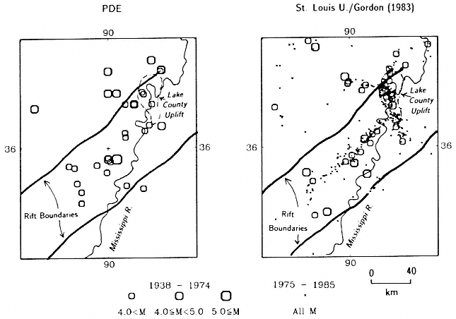
Figure 3
Two views of seismicity of the Mississippi Embayment. At left, a pre-1975 view based on epicenters
routinely determined by the U.S. Geological Survey and its predecessors and published in catalogs such
as the "Preliminary Determination of Epicenters" (PDE). At right, a view based on epicenters recorded by
the St. Louis University Mississippi Embayment Network for 1975–1985 (small diagonal crosses) and on
pre-1975 earthquakes whose locations have been recomputed using calibration events from the post-1975
era (Gordon, 1983). The rift boundaries and outline of the Lake County Uplift, though plotted in the left
frame, are taken from the post-1975 work of Hildenbrand (1985) and Russ (1982).
most active part of the seismic zone. Epicenters, Paleozoic structure, and Quaternary data now fit a fault model quite nicely. The lineations suggested by recently recorded epicenters would correspond to individual faults being reactivated under a uniform stress system (Russ, 1982); focal mechanisms of the larger shocks of the past decade are consistent with this interpretation (Herrmann and Canas, 1978). The Lake County uplift probably represents the surface expression of a basement reverse fault (Russ, 1982; Nicholson et al., 1984) similar to the anticline that represents the surface effect of the reverse-slip fault at Coalinga, California.