The People of the Above
The Foi number approximately 4500[1] and inhabit the broad valley of the Mubi River and the area to the east of Lake Kutubu, near the border of the Southern Highlands and Gulf Provinces of Papua New Guinea. The Mubi originates in the high-altitude country south of Mt. Kerewa, approximately twenty-five kilometers north of Lake Kutubu, and flows from northwest to southeast into the Kikori River (which the Foi call the Giko). Near Harabuyu village, east of Orokana mission station, it merges with the Wage River which flows into it from the north. The Mubi is also fed by the Soro River which empties from the north end of Lake Kutubu and flows southeast past the lake, parallel to the Mubi and merging with it about nineteen kilometers south of Orokana.
The altitude of the Mubi Valley ranges between 750 and 800 meters in its upper portion and drops to less than 100 meters at the point where it flows into the Kikori. The Valley is abruptly separated from the Wage River valley to the north by a range of mountains between 1400 and 1600 meters high, the Tida and Masina Ranges, and is similarly separated by a parallel ridge of lower hills to the south—the Kube Kabe and Harutami Ranges—from the interior lowlands of the Kikori basin. The entire region between the Wage and Kikori Rivers represents a series of parallel synclinal valleys and anticlinal ridges of
karstified limestone (see Brown and Robinson 1977:4) which is covered by montane rainforest in the higher altitude and by mixed sago—pandanus—Campnosperma lowland rainforest in the Mubi and Kikori Valleys (see Paijmans 1976: part 2).
The Foi are separated from their closest neighbors on all sides by large tracts of uninhabited bush. All Foi villages are located on the Mubi River or around the shores of Lake Kutubu, and the area to the north of the Mubi is used only for hunting expeditions. To the east, the Mubi is separated from the westernmost reaches of the Erave River (a tributary of the Purari) by the Go'oma River valley. Up until approximately twenty years ago, this area was inhabited by several small longhouses of Kewa-speakers from the east who had fled their homes after defeat in warfare. They were given land and political asylum by the Foi men of Kaffa and eventually left the Go'oma River entirely and settled in the southern Foi area and later with the men of Harabuyu and Yomaisi villages (Patrol Report No. 2 1955-1956; Patrol Report No. 2 1961-1962).
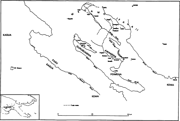
The Foi view themselves as comprising three main subdivisions (see Map 1). Those inhabitants of the four Lake Kutubu villages are known as the Gurubumena, "Kutubu people," or Ibumena, "lake people." Those Foi living along the Upper Mubi River are called the Awamena, "above people" or "northern people." Those Foi of the southern Mubi are the true Foi people, the Foimena. All three populations refer to their language as Foime , "Foi speech," despite minor dialectical differences. Murray and Joan Rule, the linguists who initially described and analysed the language, used the term Foi to refer to all people speaking this language, and their designation has been adopted by the Foi themselves.
The Mubi Valley occupies an intermediate position between the Highlands and Lowlands in every sense of the term—ecologically, geographically, and culturally. Along the Upper Mubi, the Awamena maintain intimate trading relations with the Kewa- and Wola-speaking groups of the Nembi River region, the Sugu Valley, and as far as Kagua and Nipa stations. The Foi collectively designate all Highlanders by the term Weyamo or Fahai . The Southern or Lower Foi by contrast maintain trading links with those groups living south of the Kikori River, now known as Kasere or Some (see Franklin and Voorhoeve 1973) and who the Foi themselves call Kewa.
The pronounced ecological and ethnic differences between the Mubi Valley and the Highlands region north of the Tida and Masina Ranges
Map 1.
The Foi and Neighboring Peoples
are translated by the Foi and Wola-Kewa respectively as a set of cultural and environmental stereotypes each group has of the other. The Foi point out the Highlanders' hirsuteness, their distinctive woven pubic sporrans, grass-roofed houses built right on the ground, their countryside consisting of much secondary grassland and casuarina groves, their skills at hunting, and their aggressive, argumentative personality as the defining features of that cultural region. The Highlanders in turn peer down into the mist-shrouded Mubi Valley and see it as a place of unremitting sickness and frightening monsters, and the Foi themselves as uncanny sorcerers and cannibals. These stereotypes seem to typify interethnic relationships between Highlanders and Lowlanders all along the interface of the southern edge of the Highlands cordillera. The Hull of the Tari region fear the sorcery and cannibalism of the Etoro further south, with whom they trade (Kelly 1977:15-16). The Chimbu-speakers of central Simbu Province for precisely the same reason fear the Mikaruan-speaking Daribi of the low-lying Karimui Plateau to the south (R. Hide, personal communication).
Southwest of Lake Kutubu in the area between the Lake and the upper portions of the Kikori River (called the Hegigio at this point) is the territory of the Namu Po people who are known as the Fasu. They are the most closely related people to the Foi culturally and linguistically. Across the Hegigio on the west bank are located the groups of the Mount Bosavi area with whom the Foi of Lake Kutubu have regular but infrequent contact and whom they collectively term the Kasua. Southeast of the Foi in the vicinity of Mount Murray live the Samberigi, speakers of the Sau language (see Franklin and Voorhoeve 1973). The Lower Foi traditionally had contact with these people and called the area Foraba. The Upper Mubi people consider the Foraba region as the source of their most important traditional healing cults, primarily Usi, as well as the direction from which the Campnosperma brevipetiolata (Foi: kara'o ) oil tree was originally introduced to the Foi by the two mythical ancestresses, Verome and Sosame.
Linguistically, the Foi language has been classified by Franklin and Voorhoeve (1973) as belonging to the East Kutubuan Family of the Kutubuan Language Stock (located within the Central and South New Guinea—Kutubuan Super-Stock of the Trans—New Guinea Phylum [Wurm 1978]). The West Kutubuan Family includes Fasu, Some (Kasere), and Namumi. Linguistically and culturally, the Fasu have as many affinities with the groups of the Mount Bosavi area as they do with the Foi, and they can be considered middlemen in the borrowing
of cultural traits from Mount Bosavi. The Foi of the Lake Kutubu villages, the Gurubumena, obtained from the Fasu the costume associated with the gisaro ceremony which Schieffelin (1976) describes as general to the Mount Bosavi area, and which the Foi and Fasu call kawari . They also performed the gisaro themselves and called the 'burning of the dancers' siri kebora ("resin burning; scar-making burning") after the tree-sap torches used. The siri kebora did not pass further east to the Awamena, although men of the Mubi villages occasionally participated in it as visitors to the Lake villagers' ceremonies. The Gurubumena also traditionally accepted Fasu immigrants into their villages and intermarried with Fasu. Two clans of Hegeso in fact trace their ultimate origin to Fasu territory, though their more immediate ancestors arrived at Hegeso from Yo'obo Village at Lake Kutubu where, in 1938, seven out of the eleven clans represented were of recent Fasu origin (Williams 1977:208).
Other cultural traits from the Mount Bosavi area were also adopted by the Gurubumena, including cannibalism and boys' initiation. The former was restricted to enemies slain in battle (cf. Kelly 1977:15). The practice of boys' initiation did not involve homosexual insemination as it did for the Mount Bosavi groups, although the Fasu traditionally practiced a modified form of it (in which the semen of older men was rubbed into the navels of immature initiates).
To the south, the Lower Foi maintain trade links with interior Gulf peoples such as the Kasere, from whom they obtain cowrie shell, and the Samberigi, from whom they traditionally obtained stone axes in addition to cowrie (Patrol Report No. 2 1939-1940). The most important trade links, however, are undoubtedly between the Foi and the much larger populations of the north. The Foi have always been producers of the oily sap of the kara'o tree, used by many Highlands peoples for decorative purposes. In return, the Foi receive shoats, pearl shells, and in pre-steel times stone axe blades and salt. As is the case with other groups with whom they have traditionally traded, the Foi have imported several cults and ceremonies from the Highlanders. Although it is no longer practiced, I suspect that the Ma'ame Gai~ cult was in fact the Timp Stone cult[2] of the Mendi and Nipa region (see Ryan 1961: chap. 9; Langlas, personal communication). In more recent times, the Foi have adopted the Mendi—Nipa Sa or Ya pork exchange, which they call Dawa . Unlike their own traditional Usane Habora pig-feast that was linked to the performance of certain healing rituals (see chapter 4), the Dawa is a purely "secular" ceremony for
the Foi. Its primary characteristic is the establishment of long-term rotating debts and credits in pork and shell valuables.
The residential unit of Foi society is the longhouse community (a hua , literally "house mother"). This consists of a central communal men's dwelling flanked by smaller individual women's houses on each side. The smallest such community was Kokiabo longhouse, inhabited by twelve adult men and their wives and children. The largest long-house was Damayu village with a total population of 306 in 1980. This seems to represent the upper limit of longhouse community population. Two communities—Wasemi and Barutage—divided in the recent past with one portion of each village building a new longhouse shortly after passing that limit. Hegeso had a population of 266 in 1980. At several times during my stay, men discussed the possibility of building a second longhouse that would have been used by men whose land was then at some distance from the existing longhouse.
The Hegeso men's house contains twenty-two fireplaces, eleven on each side of a central corridor, and each one nominally used by two men. The longhouse is 54.25 meters long and 7 meters wide. It is built 1.5 meters off the ground, and the peak of the roof is 4.5 meters from the floor. The women's houses (a kania ) are each approximately 8.5 meters long and 6.5 meters wide, and the height of the roof peak is a bit over 3 meters. Each longhouse has a cleared area in front and back called a wamo . The front of longhouse is that end which faces the Mubi River, conventionally designated the "upstream" (kore ) end. The back of the longhouse is "downstream" (ta'o ) and faces the bush (see figure 1).
In traditional times men built their longhouses on the tops of ridges or spurs for defensive purposes, preferably on a ridge at the river's edge so that only one end needed to be palisaded against attack. This remains the pattern today. The cleared area in which the houses are built is bordered by dense stands of multicolored cordyline shrubs and crotons (as are all dwellings) as well as pandanus, banana, hagenamo (Gnetum gnemon ), and other tree crops, and nowadays including orange, lemon, and tangerine. Each longhouse has its own canoe harbor (merabe ) along the Mubi or one of its tributaries.
Each men's house is associated politically and spatially with between two and four others which together form a distinct unit. F. E. Williams, the first anthropologist to work among Foi speakers in 1938-1939 called these units tribes (1977:171). Charles Langlas, who carried out anthropological fieldwork in Herebo Village in 1965 and
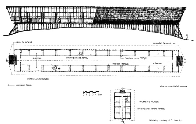
Figure 1.
Diagram of Longhouse and Women's House
1968 referred to them as regions. I have chosen to label them "extended communities." The Foi themselves lack a term to refer to these units generically but usually call each extended community by the name of one of its constituent longhouses. For example, Hegeso, Herebo, Barutage, and Baru longhouses are known as Herebo by outsiders. The four villages of Lake Kutubu are known simply as Gurubu by the eastern Foi. There are four other extended communities in the east and south.
Foi men say that these communities formed units in warfare in earlier times. While homicide and sorcery were not uncommon between coresidential men, formal warfare did not take place between longhouses of the same extended community. Likewise, these allied longhouses also comprise units in competitive feasting and exchange, and their constituent adult men consider themselves collectively responsible for amassing stocks of shell wealth and pigs for such ceremonial occasions (see also Weiner 1982b ). Foi men also recognize that each group of allied longhouses comprises an inmarrying community: Roughly half of all marriages take place between clan segments of the same longhouse, but less than 10 percent of all individuals, male and female, from an extended community marry outside of it.