The USGS Northern California Seismic Network
Origin and Development
The development of the USGS telemetered network was preceded by exploratory studies, employing dense networks of portable seismographs, of aftershocks of the Parkfield earthquake in 1966 and of earthquakes along the creeping section of the San Andreas fault in 1967. Experimental eight-station telemetered network clusters along the San Andreas near Palo Alto (1966) and San Juan Bautista (1967) were augmented by telemetered stations along the San Andreas, Hayward, and Calaveras faults to form an irregular fiftystation network by the end of 1969. Early results of these experiments (Eaton et al., 1970) showed that a dense network of simple seismographs permitted mapping of microearthquakes with sufficient precision to delineate the causative faults within the crust and to determine the style of faulting associated with them.
To provide such network coverage for the entire San Andreas fault system, which seemed essential for any serious attempt to predict earthquakes on the San Andreas, would require hundreds of stations. Considering likely constraints on funding and manpower, it was clear that stations of the network would have to be very simple and inexpensive to install, maintain, and operate. The commercial equipment employed in the experimental telemetered network appeared to be generally satisfactory, so the basic parameters it embodied were adopted for the larger network. Efforts to improve the system components in terms of power consumption, internal noise, and overall reliability have continued until the present.
A typical station consists of a 1-Hz moving-coil vertical component seismometer and a small, low-power amplifier/VCO package to prepare the seismometer signal for transmission to Menlo Park via telephone line or radio link. Both the seismometer and electronic package are sealed in short sections of plastic pipe and buried directly in the ground. Power is supplied by lithium batteries for telephone-line sites or by either air-cell batteries or solar-cell power supplies for radio sites. The constant-bandwidth frequency-division FM multiplex system used for data transmission accommodates up to eight seismic channels on one voice-grade telephone circuit, and signals from separate components or sites can be combined on a single transmission circuit by simple addition of their carriers in a summing amplifier.
Methods of recording and analyzing telemetered seismic data have evolved gradually to accommodate the growing network. Initially, incoming signals were discriminated and recorded on 16-mm film-strip recorders (Develocorders) for hand analysis. Later, backup for the network was provided
by recording the incoming multiplexed signals in direct record mode on 14-track magnetic tape. At present, primary recording and analysis of the discriminated and digitized signals are carried out by computer, although the entire network is recorded on magnetic tape, and selected stations are recorded on Develocorders for backup (Lee and Stewart, this volume, chap. 5).
The distribution of USGS stations telemetered to Menlo Park is shown in figure 1. Most stations contain only one high-gain vertical component seismograph (dots). Others contain one or more low-gain horizontal and/or vertical components as well (triangles). Stations of the UC Berkeley network in operation in 1965 before the USGS net was installed are indicated by stars.
Although the USGS network grew at an average rate of about fifteen stations per year after 1966, there were important spurts in growth in the years 1968–1970, 1975–1976, and 1979–1983. The last two spurts were in response to substantial increases in funding for the earthquake program in 1973 and 1976.
The early network was concentrated along the San Andreas fault between San Francisco and Parkfield. The present areal coverage was attained by 1980, and subsequent increases have mostly filled in and reinforced the sparser parts of the network. By the mid-1980s data from more than 400 seismographs at more than 350 USGS stations were being telemetered to Menlo Park for recording and analysis.
Frequency Response of the Seismic System and Character of its Records
The response of the standard USGS seismic system can be described as broadband intermediate frequency range. It is flat (to constant peak ground velocity) from about 1 to about 25 Hz. The lower frequency cutoff corresponds to the seismometer free period, and the upper frequency cutoff is accomplished electronically in the discriminators to suppress system noise, including cross modulation from adjacent telemetry channels. The most serious limitation of the system is its relatively low dynamic range, about 40 dB. Overall system performance also depends on the mode of recording: poorest for Helicorders and Develocorders, better for compensated tape playbacks, and best for on-line digitization at the discriminator outputs. Overall responses of the high- and low-gain USGS systems are compared with those of the big Benioff (JAS) and the standard Wood-Anderson in fig. 2.
Between frequencies of 0.2 and 30 Hz the shape of the USGS system response curve is approximately the inverse of the spectral amplitude of quietsite Earth noise (QSN, fig. 3a). This relationship insures that the amplitude of recorded Earth noise is relatively independent of frequency within that range (QSN, fig. 3b) and that the detection of signals that are only slightly larger than background noise is independent of frequency. Earthquake signals are also transformed spectrally in the recording process. Logarithmic
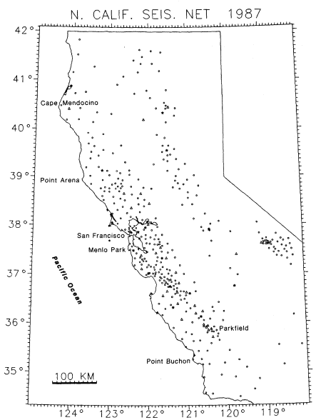
Figure 1
Northern California Seismic Net. Star = 1965 UC Berkeley station.
Triangle = Telemetered USGS station, vertical plus horizontal.
Dot = Telemetered USGS station, vertical only.
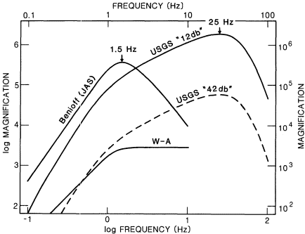
Figure 2
Magnification curves for the standard and low-gain USGS
seismic systems, the standard Wood-Anderson seismograph,
and the 100-kg Benioff seismograph.
spectral ground displacement curves for magnitude 2 and 4 earthquakes, according to the Brune source model with an average stress drop of 5 bars, are compared with that of quiet-site Earth noise and with the USGS system magnification curve in figure 3a. Such curves for magnitude 1 through magnitude 7 earthquakes, for a recording distance of 100 km, were combined with the magnification curve to produce the logarithmic spectral record amplitude curves in figure 3b. The peaks in these curves should correspond to the dominant frequencies in the records. For earthquakes between magnitude 1 and just over magnitude 4, these peaks also correspond to the respective corner frequencies in the ground displacement spectral amplitude curves. For quakes of magnitude 5 and larger, the record spectral peak and predominant frequency remain constant at 1 Hz and correspond to the natural frequency of the seismometers.
As a specific example, the predominant frequency in the record of a magnitude 3.0 earthquake should be about 4 Hz, and record amplitudes should decrease at a rate of about 6 dB/octave toward both higher and lower frequencies. Records obtained from tape playbacks of the low-gain vertical and north-south components of a magnitude 3.0 earthquake, recorded at station
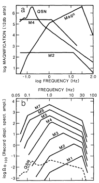
Figure 3
a) Comparison of USGS system
response curve with quiet-site ground
noise displacement spectrum (QSN) and
Brune earthquake ground displacement
spectrum curves (at 5-bar stress drop)
for magnitudes 2 and 4 earthquakes.
b) Comparison of USGS system record
spectral amplitude curves for magnitude
1 through 7 earthquakes (at 100 km
distance and for a 5-bar stress drop)
and for quiet-site noise.
HQR from a source 3 km deep and 22 km away, are shown in figure 4. In accordance with the expectation discussed above, the peak record amplitudes of this magnitude 3.0 earthquake fall in the 2.5–5.0-Hz band, and amplitudes fall off gently within the range 1–20 Hz and more abruptly at higher and lower frequencies.