Earthquake Locations
The Chile earthquake of March 3, 1985, provided an opportunity to study the tectonics of central Chile using local seismographic network data. Prior to the earthquake, a permanent network of ten stations, operated and maintained by the University of Chile, had been installed to study the Pocuro
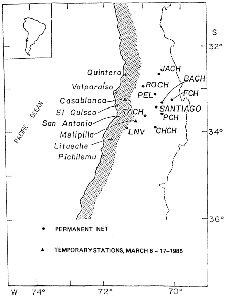
Figure 1
Permanent seismographic network of the University of Chile
and temporary portable stations from UNAM installed after the
March 3, 1985, central Chile earthquake.
fault that runs through the foothills of the Andes Cordillera. These stations are all east of the coastal region where the March earthquake occurred.
In order to better study the aftershock sequence of this event, the tenstation permanent array was supplemented by eight portable stations brought to the coast by scientists from the National Autonomous University of Mexico (UNAM). Both permanent and temporary station sites are shown in figure 1.
The 380 well-determined aftershock locations found from the data of this eighteen-station array are shown in figure 2. These epicenters were calculated using the flat layered crustal velocity model of Acevedo and Pardo (1985), with corrections in the form of P-wave and S-wave time delays at each array station, to compensate for the Earth's curvature. Only aftershocks with total recorded durations greater than 100 seconds and standard deviations in the final location of less than 0.5 seconds are plotted. S-wave arrival times were used in the locations of all 380 aftershocks.
A number of interesting features are shown by the 380 aftershocks of
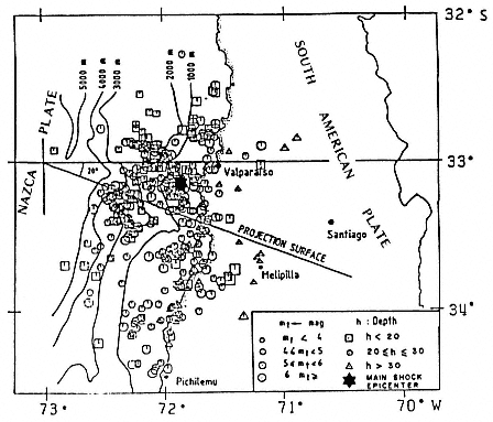
Figure 2
Location of 380 aftershocks of the March 3, 1985,
earthquake using local-network data.
figure 2. First, earthquakes with depths less than 20 km are located mainly toward the deep marine trench that marks the margin between the Nazca and South American plates. Exceptions to this rule are a few shallow earthquakes occurring nearer the coast in the northernmost part of the aftershock zone.
Second, there is a concentration of inland earthquakes with focal depths greater than 30 km to the south of 33ºS. These events could indicate a bending or breaking of the downgoing slab.
Third, there are regions relatively devoid of aftershocks to the south, north, and east of the epicenter of the main shock (shown in fig. 2 as a star). These possibly correspond to the zone of rupture of the main shock, or of the aftershocks during the first few hours after the main shock before the UNAM temporary seismographs could be installed. This conjecture is supported by several studies (Houston, 1987; Choy and Dewey, 1988) of the source mainshock using inversion of body wave amplitude data.
Finally, the aftershock hypocenters project with the least scatter onto a vertical plane striking S70°E. When projected onto this plane, the aftershocks define a fairly narrow zone dipping 10° to the east-southeast, as shown in the top panel of figure 3. The source zone so defined agrees well with one of the fault planes implied for many aftershock focal mechanism solutions (see fig. 4) and projects upward to the seafloor near the point where subduction of the Nazca plate begins. The preferred projection plane is approximately parallel to the direction of current Nazca–South American plate convergence as indicated by offshore fracture zones and paleomagnetic field-reversal data.
Many of the 380 aftershocks determined using local-array P-wave and S-wave phase-arrival information also appear in the standard earthquake catalog of NEIS (U.S. National Earthquake Information Service), which uses data from seismograph stations around the world to locate events. NEIS earthquakes, projected onto the same S70°E plane, are shown in the middle panel of figure 3. The most obvious feature of this plot is that almost all NEIS earthquakes have a standard (assigned)depth of 33 km.
It is well known that, without depth phases or phases from a few nearby seismograph stations, the depths of many events cannot be accurately determined and must be assigned. There are, however, also significant differences between the epicentral coordinates determined by NEIS and by this study for the March 3, 1985, earthquake aftershocks. These differences are summarized in the histograms of figure 5. The distance deviations of the NEIS locations relative to the local-array locations are shown in the upper panel of this figure. The mean of the distance deviations is 27 km, but almost ten percent of the earthquakes are more than 65 km apart. Azimuthal deviations appear to be bimodal, the poorest agreement occurring in the east-west direction. This observation agrees with the fact that most stations contributing data to
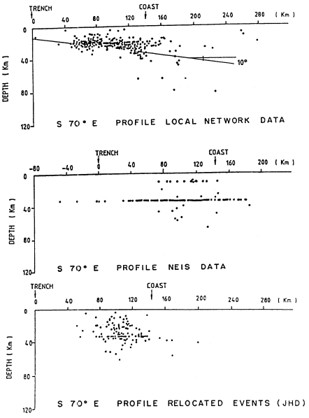
Figure 3
Projections of hypocenters located by the local network, by NEIS, and as
relocated using JHD. The plane of projection is vertical and strikes S70°E.
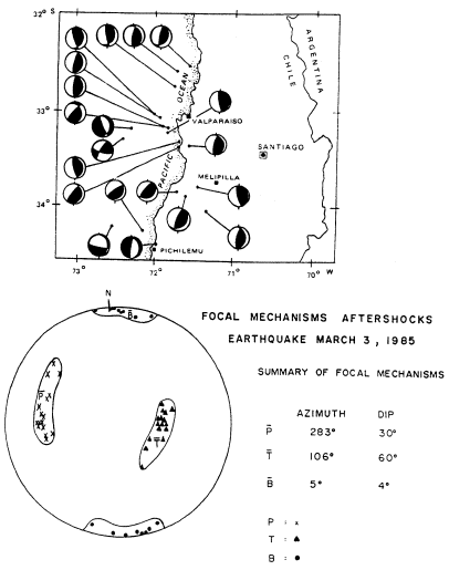
Figure 4
Fault-plane solutions of aftershocks of the March 3, 1985, earthquake.
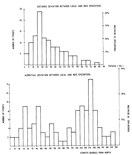
Figure 5
Distance and azimuthal deviations between local and NEIS epicenters.
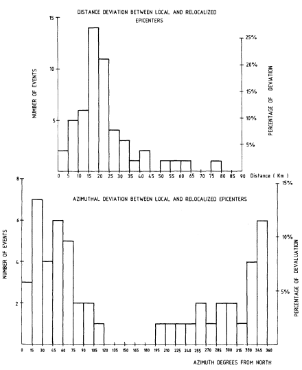
Figure 6
Distance and azimuthal deviations between local and relocated (JHD) epicenters.
NEIS are located north of central Chile, resulting in larger errors in longitude than in latitude.
The NEIS data using the Joint Hypocenter Determination algorithm (Dewey, 1970) have been reanalyzed by Choy and Dewey (1988). Results of this reanalysis are shown in the bottom panel of figure 3. It is clear that the depths of the aftershocks are still not well resolved, and that it is difficult to see the configuration of the subducted lithosphere from these hypocenters. Yet some improvement in agreement between these aftershock locations and the local-array locations is apparent from the comparisons provided by the histograms of figure 6. The mean of the distance deviations has been reduced to 22 km, and azimuthal deviations are now dominantly to the north, toward the NEIS stations.