Historical Development of Earthquake Location
Pre-Instrumental
In considering the development of earthquake location, we must not neglect the contributions made by noninstrumental seismology. The reporting of earthquake effects is still a major part of observational seismology and a useful adjunct to instrumental recording, but until a century ago it was the only method of studying earthquakes and their distribution. One of the earliest attempts at a global earthquake plot was a catalog produced by the Irish scientist Robert Mallet (1858). This was based entirely on felt reports, thus missing the details of major seismic features of the oceanic ridges, and showed a combination of population and earthquake distributions. Nevertheless, it was a creditable first approximation to a world seismicity map.
Among others prominent in early studies of global seismicity was the French observer Montessus de Ballore (1896), who published a paper with the impressive title "Seismic Phenomena in the British Empire" and realized the need to distinguish between places where earthquakes were reported felt and actual centers of vibration. He also produced early hazard maps, including one for the British Isles (fig. 1).
Good pre-instrumental information may still be subjected to analysis techniques developed later. An example is Eiby's (1980) analysis from the diaries of a clergyman in Wellington who meticulously noted the time and characteristics of aftershocks of the large 1848 earthquake in the north of the South Island of New Zealand. This provided good estimates of the relative numbers of large and small earthquakes (magnitude-frequency parameter b ) and rate of decrease with time of the numbers of aftershocks (decay parameter p ).
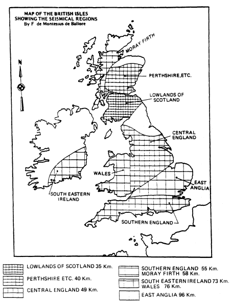
Figure 1
Hazard map of Britain (Montessus de Ballore, 1896). Distances
given in kilometers are an arbitrary measure of seismicity inversely
related to the number of earthquakes in a given region.
Early Instrumental Seismology on a Global Scale
World networks of seismographs, such as the Worldwide Standardized Seismographic Network (WWSSN), the Global Digital Seismographic Network (GDSN), and the Incorporated Research Institutions for Seismology (IRIS), are not new. Early outstations were set up by European countries, such as the German station at Apia in Samoa in 1902, but the first serious attempt at global coverage was the network of the British Association for the Advancement of Science (BAAS) established by Prof. John Milne on his return to Britain from Japan in the late 1890s. The Milne network at its peak had about ten stations in the British Isles and nearly thirty elsewhere throughout the world. The network comprised instruments of standard manufacture from which Milne collected readings at his home in the Isle of Wight in the first systematic analysis of global seismicity. From this enterprise, whose results were published as the Shide Circulars of the BAAS, there developed the International Seismological Summary (ISS) and, later, the International Seismological Centre (ISC). Under Milne, for the first time the true pattern of instrumentally determined global seismicity began to emerge, as shown in his earthquake map for 1899, which also shows the distribution of Milne seismographs (fig. 2; Milne, 1900).
We must remember that the knowledge of earth structure at that time was very elementary, and the instruments low in magnification (about 12), long in period (about 12 s natural period), and undamped, with surface waves as the main recordings. The general accuracy of location was surprisingly good, but naturally mistakes are apparent in the light of modern knowledge. One great strength of the network was its uniformity, which has helped in a recent reevaluation of Milne's locations of early events in West Africa (Ambraseys and Adams, 1986). Irrespective of details, it was often possible to establish by a similarity of reporting that certain stations were nearly equidistant from a given earthquake. We found that consistent locations could be found by using the reported time of the maximum oscillation, M , assuming it to be an Airey phase of velocity 2.8 to 3.0 km/s. In this way we could confirm the location of many early events, but some we found to be grossly misplaced. An example is the event of May 21, 1910, originally placed in Niger in Central Africa but found by us to be in Turkey, where there was confirmatory felt information (fig. 3).
Damped instruments of greater sensitivity were developed after about 1910, and fuller details of P and S phases were recorded but at the expense of uniformity of recording. By 1930 the number of recording stations had grown, and a map (fig. 4) compiled by Miss Bellamy (1936) of ISS shows well the main features of global seismicity, but with the details blurred by scatter. The stations at that time are shown in figure 5.
The number of stations grew steadily, and by 1951 about 600 were listed with their direction cosines in an ISS publication. The distribution of sta-
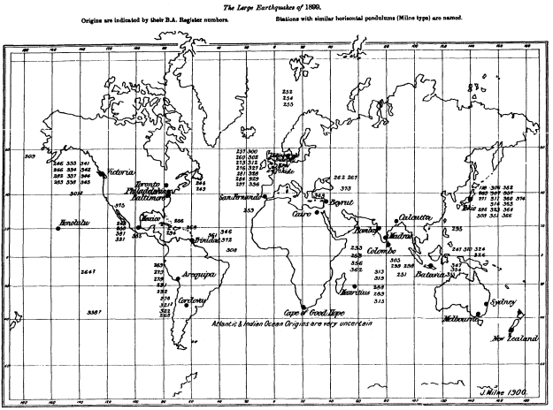
Figure 2
Global earthquakes and seismograph stations in 1899 (Milne, 1900). Epicenters
are approximately indicated by numbers that refer to events in Milne's catalog.
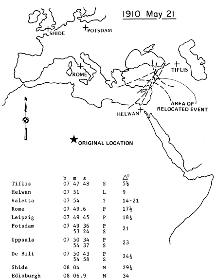
Figure 3
Relocation to Turkey of an event originally placed in Niger (Ambraseys
and Adams, 1986). Arrival times are given for stations with reinterpretation
of phases and derived distances in degrees.
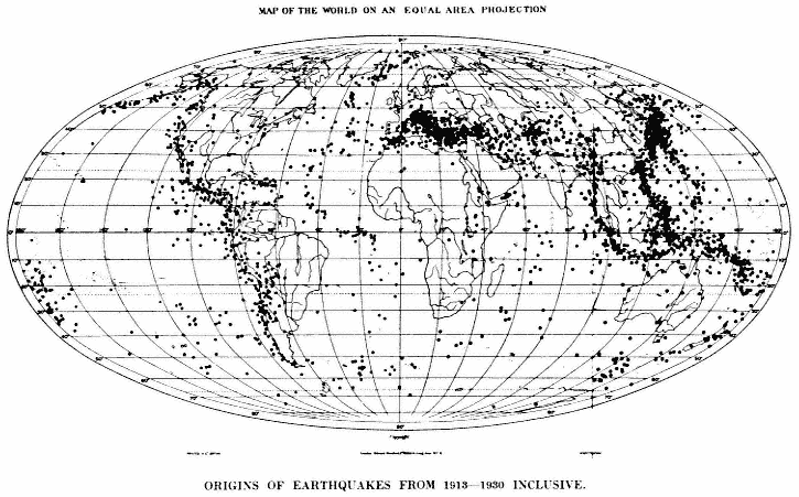
Figure 4
Global earthquakes 1913–1930, showing scatter of features now better defined (Bellamy, 1936).
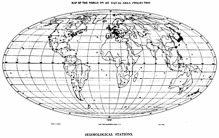
Figure 5
Seismograph stations in 1936 (Bellamy, 1936).
tions, however, remained very uneven, with strong concentrations in North America and particularly in Europe. At the time the New Zealand station Roxburgh was installed in 1957, at latitude about 45°S, it was the most southerly regularly operated station in the world, still leaving the southernmost thirty percent of the world's surface with no station. The advent of the International Geophysical Year, and the installation of about 120 WWSSN stations in the late 1950s and early 1960s, changed the picture enormously; since then the coverage of recording stations has significantly improved.
Felt Reporting
The contribution to observatory seismology of felt information, even in present times, must not be underestimated. Properly documented felt reports can add valuable information, and in some parts of the world they still provide the most accurate locations. Felt reports of a small earthquake often give a more reliable location than can be determined from readings at a few stations, and a well-determined felt pattern for a large event will define the center of energy release, which may be closer to the centroid-moment tensor solution than to the less significant point of initation of rupture that is given by the instrumental hypocenter. Ambraseys and his co-workers (for example, Ambraseys and Adams, 1986) have developed formulae for estimating surface wave magnitude, Ms from isoseismal radii. These estimates have been shown to agree well with instrumentally determined values.