Ten—
Seismicity of the Australian Plate and its Pacific Plate Margin
David Denham
Introduction
The patterns revealed in plots of earthquake hypocenters are crucial for interpreting tectonic processes within the Earth. At active plate boundaries, where a satisfactory model has been developed, hypocentral locations provide inportant information on tectonic details. Even in complicated areas, studies of the spatial distribution of earthquakes can provide considerable information on the geometries of the plate margins and the subduction zones. In the New Guinea region, for example, where the Australian and Pacific plates interact strongly, there is not one simple plate boundary but a cluster of small plates, each boundary accommodating a component of the total interaction. Furthermore, there is not one single subduction zone but several. For the Australian continent, however, which is an intraplate environment, there is no comparable tectonic model to successfully interpret the seismicity patterns. We know very little about the causes of this seismicity, except that the earthquakes are all shallow and caused by compressive forces, and that large earthquakes can and do occur in the Australian region. The task of developing a successful model to describe intraplate seismicity patterns is one of the most important seismological problems to be tackled in the next decade.
Background
It is fitting, in this centennial anniversary symposium, that the first session is devoted to the mapping of earthquakes. For if one examines the advances associated with matters seismological, it is clear that these have, in many instances, depended on the available capability to locate and map earth-
quake hypocenters. Readers need hardly be reminded of the role played by seismology and seismologists in the development of plate tectonics, and how the delineation of plate boundaries was achieved by interpreting the spatial patterns of hypocenters. It was not enough to simply plot the hypocenters; it was necessary to interpret the patterns in terms of a meaningful model. Thus we have another example of the old adage that you see only what you know, and I suppose if any theme characterizes this paper, this is it. If you can fit the observations to a model, then all is well; if you can't, you have problems.
What I intend doing is to look at two regions associated with the Australian plate and demonstrate how, over the past eighty years or so, our improved capabilities to map earthquakes have led to an enhanced understanding of the tectonic processes in one region, where we have a model, and have led to little progress in the other region because we don't have a model. The two regions are the northern margin of the plate in the vicinity of New Guinea, and that part of the Australian plate occupied by the Australian continent (fig. 1).
Papua New Guinea
The first publication on the seismicity of Papua New Guinea was probably Sieberg (1910), which was based largely on reports of earthquakes from the church missions established there close to the turn of the century. He listed twenty-four earthquakes that occurred in the period 1900–1906 (fig. 2). He even attempted to interpret the seismicity in terms of the tectonics of the region. However, apart from recognizing that "New Guinea and the Bismarck Archipelago form part of the innermost arc of young folded mountains which approach the rigid Australian platform," his general conclusion was that "our knowledge is very deficient in this respect, because only sporadic observations are available."
By the time Gutenberg and Richter's Seismicity of the Earth was published in 1954 the data set had improved considerably, and most epicenters were computed using arrival times recorded at seismographic stations. They used a time window from 1904 to 1952 and came close to relating earthquakes to a plate-tectonic type of activity. For example, they recognized (pp. 97–101) that "Most of the earth's surface is partitioned among a number of comparatively stable blocks, separated by active belts" and "the foci of deep shocks seem to be restricted to the vicinity of a nearly plane surface, which is probably related to a thrust surface between two different structures, usually dipping towards the continent." However, they mistakenly suggested that the midocean ridges "can hardly be young structures" even though they recognized that in the case of the mid-Atlantic ridge "Its parallelism with the continental coasts is so close that it practically demonstrates a mechanical connection with them." It is interesting to note that in the Papua New
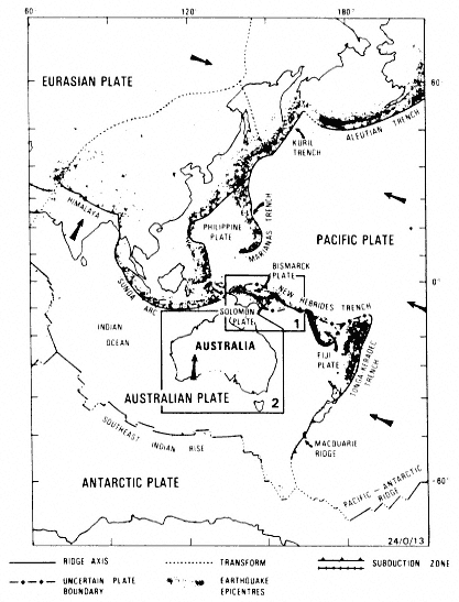
Figure 1
The Australian plate and its boundaries. Area 1 defines the New
Guinea region and Area 2 the Australian continent, the two
regions discussed in the text. Arrows indicate the directions
of plate motion relative to the Antarctic plate.
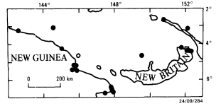
Figure 2
New Guinea epicenters for 1900–1906 (Sieberg, 1910).
Guinea region the main features of the shallow, intermediate (70–300 km), and deep (> 300 km) earthquakes had by then been determined, which is quite remarkable when one considers the extent of the global network in the pre-1950s, and also the absence of any regional stations at that time.
In Japan, meanwhile, Wadati (1934), using data from regional stations, had been able to define quite precisely the zone of earthquakes dipping beneath Honshu, and had also suggested that "This tendency seems to be observable in many volcanic regions in the world. Of course, we cannot say decisively but if the theory of continental drift suggested by A. Wegener be true, we may perhaps be able to see its traces of the continental displacement in the neighbourhood of Japan"—not bad for 1934.
In New Guinea, the next study after Gutenberg and Richter was made by Brooks (1965) who applied data from 1906 to 1962 to earthquake risk assessments. His results do not represent a significant improvement over Gutenberg and Richter's earlier work. However, Denham (1969) used data from the period 1958–1966 in an attempt to interpret the hypocentral patterns in terms of the fledgling plate-tectonic theories being developed at the time. Figure 3 shows his results. There is a significant improvement in the definition of the lineations, and it is clear that the northern boundary of the Australian plate is not a simple boundary. The reasons for the improvements in the data set were mainly due to the establishment of the Worldwide Standardized Seismographic Network (WWSSN) in the late 1950s and early 1960s and the computing facilities of the U.S. Coast and Geodetic Survey (USCGS). Some indication of the improvements may be gauged from the fact that only 256 events from the region were listed by Brooks (1965) for the period 1906–1962, whereas in 1966 alone 309 earthquakes were located in the same region by the USCGS.
Denham (1969) was able to identify the zones of deep and intermediate-depth earthquakes associated with the volcanic arcs and also the Bismarck Sea Seismic Zone (BSSZ). This is defined by the line of epicenters extending from 143° E to 152º E at 3° S. However, the northern boundary of the Aus-
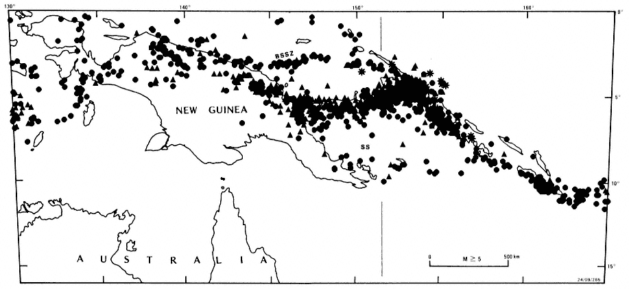
Figure 3
New Guinea epicenters for 1958–1966 earthquakes with M ³ 5 (Denham, 1969). BSSZ indicates the Bismarck Sea Seismic Zone, and SS indicates the Solomon Sea.
tralian plate was probably misidentified as being along the northern coast of the island of New Guinea and the northern margin of the Solomon Sea (SS).
As shown in figure 4, compiled from more recent data, this interpretation is probably not correct. The northern margin of the Australian plate is situated farther to the south. In figure 4 all epicenters located by twenty or more stations since 1970 have been plotted. The improved regional seismographic coverage since that date has revealed a zone of seismicity in the central part of the main island of New Guinea (A-Á in fig. 4a) and another zone near the East Papuan peninsula (see Ripper and McCue, 1983). These diagrams indicate the details that can be revealed with a good-quality data base. Each lineation can be interpreted in terms of plate tectonics and the interpreta-
tions checked by analyzing fault-plane solutions and observations of recent crustal movements.
At depths between 70 and 300 km the hypocentral lineations are equally well determined and can be interpreted in terms of subducting lithosphere (fig. 4c). Similarly, for earthquakes deeper than 300 km (fig. 4d) the slabs (or what is left of them) are also clearly identified.
Therefore, in a plate margin situation, even though the tectonics are complicated it is possible to use the spatial distributions of earthquake hypocenters to unravel the current dynamics of the region. Such inferences are not possible in an intraplate environment where no suitable model for earthquake occurrences has as yet been developed.
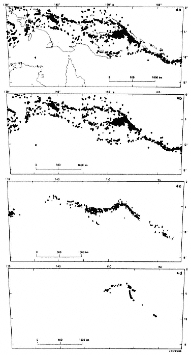
Figure 4
New Guinea epicenters for 1970–1984 where twenty or more
stations have been used to locate the hypocenters.
(a) Shallow (0–50 km) earthquakes with coastlines. A–Á
indicates the northern margin of the Australian plate
in the center of New Guinea.
(b) Shallow earthquakes without coastlines.
(c) Intermediate Depth (70–300 km) earthquakes
without coastlines.
(d) Deep (> 300 km) earthquakes without coastlines.
Notice how the shallow earthquakes define the plate and
subplate boundaries, and the intermediate and deep
earthquakes define the subducted slabs.
Australian Continent
Earthquakes have been reported from the Australian continent since the First Fleet landed in 1788, but it was not until 1952 that a study of Australian seismicity was published (Burke-Gaffney, 1952). This was followed by Doyle et al. (1968), whose comprehensive study listed 165 earthquakes in the period 1897 through 1966. This data set is not large enough to determine any meaningful patterns.
If we examine a more recent data base including earthquakes through 1984, the situation is essentially unchanged (fig. 5). The epicentral patterns, or lack of them, are difficult to interpret in terms of a tectonic model. It is clear that most of the earthquakes occur within the continent, but the patterns of epicenters do not appear to correlate with any significant geological feature. Figure 5a shows the distribution of earthquakes and the main geological features, and figure 5b shows the earthquakes without visual distractors. Although there are several hundred epicenters, it is difficult to develop any continent-wide model that describes the occurrences. However, we can make the following statements.
1. The earthquakes in the Australian region appear, for the most part, to be restricted to areas of continental crust (Lambeck et al., 1984).
2. The patterns appear to define regions of comparatively high seismicity, which surround regions of lower seismicity.
3. All onshore earthquakes occur in the upper 20 km, and most are in the upper 10 km (Lambeck et al., 1984).
4. Although in some small areas the earthquakes appear to be associated with known faults (Bock and Denham, 1983), in many instances—particularly for large earthquakes—there is no apparent correlation between the earthquakes and pre-existing faults.
5. All reliable focal mechanisms obtained to date (thirty-eight) are consistent with the presence of compressive stress in the crust—confirmed by in-situ stress measurements and surface-faulting observations (Denham, 1986; Lambeck et al., 1984).
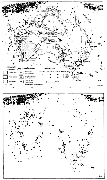
Figure 5
Australian epicenters of magnitude 4 or
greater earthquakes, 1873–1985,
(a) showing the main geological features and
(b) without visual distractors. Notice
how the epicenters appear to group around
areas that have experienced no earthquakes.
Apart from these statements, which describe particular aspects of the seismicity in the Australian region, I would conclude that at present there is no reliable model to describe the overall space-time earthquake patterns.
Discussion and Conclusions
At the northern boundary of the Australian plate, in the Papua New Guinea region, even though the tectonics are complicated, detailed and accurate mapping of earthquake hypocenters can provide important information on the plate boundaries and subduction zones. This is because the patterns can be interpreted in terms of a known plate-tectonic model. However, for the Australian continent, which is an intraplate environment, there is no comparable model that can be used successfully to interpret the seismicity patterns. Thus, the development of a successful model to describe intraplate seismicity patterns is one of the most important seismological tasks to be tackled in the next decade, because large earthquakes can and do occur in intraplate regions.
Acknowledgment
I thank the Director, Bureau of Mineral Resources, Geology and Geophysics, for permission to publish.
References
Bock, G., and D. Denham (1983). Recent earthquake activity in the Snowy Mountains region and its relationship to major faults. J. Geol. Soc. Australia, 30: 423–429.
Brooks, J. A. (1965). Earthquake activity and seismic risk in Papua and New Guinea. Australian Bureau of Mineral Resources, Geology & Geophysics, Report No. 74.
Burke-Gaffney, T. N. (1952). Seismicity of Australia. Journal and Proceedings of the Royal Society of New South Wales, 85: 47–52.
Denham, D. (1969). Distribution of earthquakes in the New Guinea-Solomon Islands region. J. Geophys. Res., 74: 4290–4299.
——— (1986). Stress patterns in the Australian continent—Evidence from earthquakes, borehole deformations, and in-situ stress measurements, (abstract). In Earthquake Notes 57: 5.
Doyle, H. A., I. B. Everingham, and D. J. Sutton (1968). Seismicity of the Australian continent. J. Geol. Soc. Australia, 15: 295–312.
Gutenberg, B., and C. F. Richter (1954). Seismicity of the Earth and Associated Phenomena. Princeton University Press, Princeton, N.J., 310 pp.
Lambeck, K., H. W. S. McQueen, R. A. Stephenson, and D. Denham (1984). The state of stress within the Australian continent. Annales Geophysicae, 2: 723–742.
Ripper, I. D., and K. F. McCue (1983). The seismic zone of the Papuan fold belt. BMRJ. Australian Geol. Geophys., 8: 147–156.
Sieberg, A. (1910) Die Erdbebentatigkeit in Deutsh-Neuguinea (Kaiser-Wilhelmstand und Bismarck-archipel). Petermanns Geographische Mitt., II, Heft 2/3.
Wadati, K. (1934). On the activity of deep-focus earthquakes in the Japan Islands and neighborhoods. Geophys. Mag., 8: 305–325, Tokyo.