Chapter XVIII—
Salamanca Province:
The Despoblados and Alquerías
Because eighteenth-century reformers believed that the Spanish countryside suffered from a lack of population, they found the cause of the agricultural backwardness of the province of Salamanca in its large number of despoblados, a verdict that recent historians have echoed.[1] Several despoblados have played a role in our story. Royal plans to repopulate them led to the migration of settlers from La Mata to the despoblado of Narros de Valdunciel. The vecinos of Villaverde did not move their residence, but they broke grazing land in the neighboring despoblados of La Cañada and La Cañadilla, increasing their harvests in this way. Sixty percent of Pedrollén was sold in the disentail, but it had been and remained a single exploitation, rented by one tenant, so far as one can tell from the census returns.[2]
Despoblados resembled the cortijos of Andalusia, another abomination of the reformers, but they differed in essential ways. Pedrollén, although a single exploitation, had several owners and the shares could be sold separately. Many despoblados, legally single properties called cotos redondos or términos redondos, were owned in shares by various people, but I have found no such case of a cortijo. The latter were carved out of vacant municipal land and may have had their origin before the Reconquista. The despoblados were the result of a historical process since the
[1] See García Zarza, Despoblados, 88 and passim; and Domínguez Ortiz, "Ruina de la aldea," 110. Domínguez Ortiz does not consider specifically the case of Salamanca.
[2] Although Pedrollén was called an alquería in the official index (nomenclátor ) of 1789, it was listed as a despoblado in 1769 (García Zarza, Despoblados, 146).
Reconquista that removed the inhabitants from an established village, or so at least the name implied. The Christian resettlement of Salamanca took place after the middle of the eleventh century, apparently in the form of many small villages and hamlets placed in close proximity. A despoblado arose when the population of a village was reduced to one or two families or disappeared altogether, but even when all fixed population vanished, the name and administrative unit persisted. Cortijos were not separate political or census units.
Why despoblados had declined is not clear. The times of greatest loss of population would appear to be the hundred years following the Black Death and the seventeenth century, periods of plague and demographic crisis throughout western Europe. Two authors who have studied similar deserted villages in France argue, however, that plagues alone cannot account for the complete disappearance of villages. The destruction and military levies of wartime played their part in driving away the inhabitants. Permanent depopulation did not result, however, unless other causes prevented resettlement once the hardships had passed. One might be adverse physical conditions, another the desire of a landowner to build up his estate. The smaller the hamlet, the more likely it was to disappear, but it was rare for a place to be abandoned completely. Some farmstead, some group of people remained to keep alive its name.[3]
The story in Salamanca is similar, suggesting that the causes were not unique to this region or to Castile. Antonio Domínguez Ortiz believes that small settlements disappeared in the centuries after the reconquest because the insecurity of the open countryside drove the peasants to seek safer and more healthy locations. After 1250 there was a great demand for settlers in Andalusia, and many may have been attracted by this opportunity.[4] Eugenio García Zarza, who has studied the despoblados of Salamanca most closely, points to the action of noble lords, desirous of creating large estates as a basis for political power during the struggles of aristocratic bands in the fifteenth century. They forcibly moved peasants to larger towns, a procedure renewed in the seventeenth and early eighteenth centuries, when the crown was again weak. Seventeenth-century wars with Portugal, destructive and demanding in money,
[3] Pesez and Le Roy Ladurie, "Deserted Villages," 95. A fuller version of this study appears as Pesez and Le Roy Ladurie, "Le cas français." This volume includes Cabrillana, "Villages désertés en Espagne," 461–512, which attempts to identify the despoblados in much of Spain but does not cover the territory of the crown of Castile north of the central sierras. Anes, Crisis, 181 n. 29, questions its figures.
[4] Domínguez Ortiz, "Ruina de la aldea," 106–7. On migration to the south, see MacKay, Spain in the Middle Ages, 70–72.
and the increasing tax burdens, which hit the remaining peasants ever more heavily as the others fled or died, completed the desertion of the villages.[5] Curiously, these historians make no mention of the Black Death as a contributing cause to the depopulation, although students of medieval France and England have stressed its central role in the redistribution of population. Plagues of the fourteenth and fifteenth centuries are known to have laid waste Catalonia, Aragon, and Navarre.[6] In 1350 the Black Death had spread so widely in Castile that Alfonso XI wrote to Pedro IV of Aragon, expressing his concern about the loss of population and the number of his subjects going to Rome to obtain a papal indulgence.[7] The following year, the Cortes of Castile heard complaints that the great mortality had raised the price of agricultural labor to such heights that owners were being forced to abandon cultivation.[8] The plague may well have been the event that triggered the early desertion of the smaller places in Salamanca.
What is unique about Salamanca is the large number of despoblados that appeared, far above anything found in France or the rest of Spain. The catastro identified 113 in the study area, while the nomenclátor of 1789 raised the number to 197, plus another 93 in the partido of Ciudad Rodrigo.[9] Most lay in the poor plains southwest and west of Salamanca city, that is, on the large property side of the Salamanca-Albacete line, but a number were also in the rich plains north and east of the city. Almost indistinguishable from the despoblados were places called alquerías, large properties tended by one or several families. Although this name, derived from the Arabic word for a small settlement, does not imply that they were ever larger, the available censuses show that many had had more people in the past.[10] The catastro does not identify alquerías as such, but the nomenclátor names 151 of them in the study area, located in the same regions as the despoblados, and 30 more in the partido of Ciudad Rodrigo.
[5] García Zarza, Despoblados, 36–51, 65–82.
[6] Vilar, Catalogne 1 : 464–66; Vicens Vives, Manual, 163–64; Cabrillana, "Villages désertés en Espagne," 493–95, 504.
[7] Letter referred to in Pedro IV of Aragon to Alfonso XI of Castile, 30 Mar. 1350, in López de Meneses, Documentos acerca de la peste, 377–78.
[8] García Fernández, "Champs ouverts," 707–8.
[9] AHN, Hac., libro 7476, letra D: Partido of Salamanca, 78; of Alba, 11; of Ledesma, 24. García Zarza, Despoblados, 149–51, lists these.
[10] Instituto geografico y estadístico, Nomenclátor . . . de 1900 2 : 356, defines an alquería in Salamanca as "a rural house inhabited by the owners or tenants of surrounding fields used for the cultivation of cereals."
Why this concentration of deserted villages in Salamanca? The activities of noble estate builders and the destruction of war and taxes were not peculiar to this region. One must look for a scenario that fits the local situation. From the ninth to the eleventh century, the region was a no-man's-land between the Christian monarch of León and the Muslim states south of the central sierras and was virtually without permanent residents. After the reconquest of Toledo in 1085, the future province of Salamanca came permanently under Leonese rule. Salamanca city was fortified and given a cathedral, and the smaller places, Alba de Tormes and Ledesma, also became strongholds. Rural settlement was done in small nuclei, villages and hamlets of only a few families. Some settlers came as organized groups originating in a town in the north, others had been collected under the leadership of some enterprising individual of higher social status. Frequently the name of the new village reflected the origin of the settlers or the person who founded it. Such toponymic evidence indicates that the new inhabitants came from all over: Galicia, León, the Basque lands, and Navarre to the north as well as a large number of Mozarabes (Christians who had been living in Muslim territories) and Moriscos (converted Muslims) from the south.[11]
Settlement tended to follow the old Roman road from León to Salamanca and south through Béjar to Mérida, spreading out to the east and west from it. The rich Armuña plain north of Salamanca city was repopulated before the mid-twelfth century; by 1200 its towns were substantial nuclei. The poorer zone south of the city filled up a generation or two later, and the southern sierras between about 1190 and 1230. One can picture these early hamlets as a half-dozen or so houses and a few sheds around a small unpretentious church. The nearby arable had been distributed in fields to the settlers in a reparto, while the common pastures and woodland lay beyond. It is possible that some places were private estates with only a few permanent hands, protoalquerías, especially those in the poor plains bearing the name of the founder. Many villages were required to make payments to the cathe-
[11] Four places named Naharros (Narros), a Naharillos, and two Naharra reflect the immigration from Navarre, while three Gallegos, two Galleguillos, and a Nava Gallega, that from Galicia (six of these thirteen places were despoblados or alquerías in 1789). There was also a Córdoba, a Cordobilla, and a Mozárvez (Mozárabes), a Morisco, and a Castellanos de Morisco. Founders' names appear in Aldehuela de los Guzmanes, Gutierro Velasco, Martín Pérez, Andrés Bueno, Gimén Gómez, Velasco Muñoz, and so forth (all of these being despoblados in the eighteenth century). See Julio González, "Repoblación de la 'Extremadura,'" 241–45, and Julio González, "Reconquista y repoblación," 176–81. These are the sources for this and the next paragraph.
dral of Salamanca, but jurisdiction lay with the council of one of the fortified centers, Salamanca, Alba de Tormes, or Ledesma; the basis was already established for the later partidos. Except for a few places under ecclesiastical jurisdiction, señorío did not come until later; the cities and villages were royal.
When hardship came in the form of plague and civil strife in the fourteenth century and later, those settlements located where the natural conditions were least favorable, notably in the thin topsoils south and west of Salamanca city, suffered most. The villagers still alive in the smallest villages, places with less than ten families, some as few as two, chose to go to bigger towns or were forced to do so by local magnates who desired unobstructed use of the fields. But the places did not disappear from official records. The owners chose to preserve their names and identity so that they would not be taken over by neighboring towns as common wastes and pasture.[12] These places had never flourished under farming, and the rise of migratory and sedentary sheep raising after the fourteenth century made them profitable as pastures, turning them into permanent despoblados.
Angel Cabo Alonso, the leading historical geographer of the province, emphasizes the importance of geographic conditions in explaining the appearance of despoblados. They were found, he says, in the plains where the underlying rock formation lay closest to the surface of the sedimentary deposits, leaving little soil cover for crops. He theorizes that after the reconquest the larger settlements were along the rivers and streams, while the future despoblados were smaller hamlets that appeared in the hilly interfluvial spaces and never became populous villages.[13] One needs a case-by-case study to test this hypothesis. It undoubtedly applies to many places, but not all, because there are authenticated accounts of forcible removal of villagers in the fifteenth century,[14] while the first census available, from 1534, still shows numerous vecinos in many places that would be despoblados in the eighteenth century.[15] What seems indisputable is the importance of the physical characteristics of the plains, first in attracting early settlers into numerous small hamlets and then in proving unsuited to the permanent arable culture needed to support so many nuclei. The settlers had set up life in the
[12] See García Zarza, Despoblados, 28–29.
[13] Cabo Alonso, "Antecedentes históricos," 65–66. Anes, Crisis, 181–86, also questions the belief that all despoblados had once been populated centers.
[14] García Zarza, Despoblados, 36–48.
[15] Tomás González, Censo . . . siglo XVI, Appendix 5.
way familiar to them, only to discover too late that the physical reality would not accept it here. Theirs was not the last such experience, witness the American Dust Bowl of the 1930s.
2
The data collected for this study permit one to look at the despoblados in several new ways. Most of the following discussion is limited to the despoblados for which there are individual surveys of the catastro, but, unlike previous studies, it also considers the alquerías. Table 18.1 shows what percentage of the catastro units in each zone fell into these two categories. Those with the greatest concentration of despoblados and alquerías were the four plains zones, SA to SD, and the hilly zone SF that juts between zones SB and SC. The following analysis is limited to these five zones.
Most of the despoblados were smaller in area than the units that had survived as towns; in three of the five zones they had a mean size less than half that of the regular places. According to the returns of the catastro, their mean size ranged from 490 fanegas (about 220 hectares) in
| |||||||||||||||||||||||||||||||||||||||||||||||||||||||||||||||||||||||||||||||||||||
| ||||||||||||||||||||||||||||||||||||||||||||||||||||
zone SD (Ledesma) to 1,150 fanegas (about 510 hectares) in zone SB (Alba de Tormes; Table 18.2). In fact 43 percent of them contained less than 250 hectares, a figure that has been considered the minimum size of a large property or latifundio in twentieth-century Spain.[16] Alquerías tended to be somewhat larger, although still smaller than settled towns. A community located in such a place, especially where the land was poor, was at a decided disadvantage when faced with climatic catastrophes or human violence.
The evidence from censuses permits one to assign the decline in population of most despoblados and alquerías to one of three periods: prior to the census of vecinos of 1534, between 1534 and the census of vecinos of 1712, and the period between 1712 and 1826, for which we have the catastro (ca. 1751–53), the census of 1786, and Miñano's dictionary with figures for 1826. Table 18.3 shows the distribution among these three periods of those places for which some census data are available. Since the first census is for 1534, we can know only whether a place was at its demographic low point by that date. We do not know that it had ever been larger, and in view of the doubts of Cabo Alonso on this question, one should leave it open. Some certainly had been larger at some previous time.
[16] See Malefakis, Agrarian Reform, 21, Map 1.
| |||||||||||||||||||||||||||||||||||||||||||||||||||||||||||||||||||||||||||||||||||||||||||||||||||||||||||||||||||||||||||||||||||||||||||||||||||||||||||||||||||||||||||||||||||||||||||||||||||||

Fifty percent of the despoblados and alquerías for which there are census data had become depopulated by 1534 or had never been large. Ledesma (SD) zone had the most marked early decline, with 65 percent of its small places in this category. The other half of the places, those that lost their population after the sixteenth century, are of greater interest to us. Without zone SD for which we lack 1712 figures, seventy-nine places lost their settlers before 1712 and forty-nine after that date. Most of the first group had between five and twenty-four vecinos in 1534 and had dropped to two vecinos or less by 1712. They had gone from small towns of twenty to a hundred people to a family or two tending an estate, or even to no one at all. A few continued their decline into the eighteenth century. Riolobos (SB) had thirty-six vecinos in 1534 and was down to six in 1712. By 1751 it had only one household and in 1786 only a man and a woman, not married. Arauzo, nearby, had thirty vecinos in 1534, ten in 1712, and only two in 1751; there were at least seven other similar places.
From official reports and literary sources, it is evident that the big decline came in the seventeenth century, a time of epidemics, war, and heavy taxes.[17] Marginal arable fields, some of them probably first broken in the sixteenth century, returned to pasture, the number of sedentary sheep increased, and peasants collected into the larger villages.[18] A document dated 1661 protesting the dire effects of the war with Portugal claimed that the partido of Salamanca city had seen the number of towns (lugares) decline from 270 to 100 in eight years and the number of vecinos from four thousand to two thousand, an exaggeration, of course, but evidence that contemporaries were aware of the impact of these difficult times.[19] A study of the villages northwest of Paris found that those with five to twenty households were especially susceptible to disappearance in the late medieval and early modern periods.[20] The fate of the towns of Salamanca seems to demonstrate a similar critical mass, under twenty-five households they were likely to become despoblados, an outcome to which they were also inclined by their smaller extent and poor soil.
The places that lost their population after 1712 were mostly of a different kind. Of the forty-nine places in the four zones in this category,
[17] See García Zarza, Despoblados, 65–82.
[18] See Anes, "'Depresión' agraria."
[19] Anes, Crisis, 117. See ibid., 88–126, on the seventeenth-century depression.
[20] Guy Fourquin, "Villas et hameaux du nord-ouest de la région parisienne en 1332," Paris et l'Ile de France 9 (1957–58): 141ff., cited in Pesez and Le Roy Ladurie, "Deserted Villages," 74–75.
only five had more than 4 vecinos in 1712, none more than 7.5 (widows heading households counted as half vecinos). By the time of the catastro, twenty-eight reported no vecinos at all. Most of these appear never to have been even hamlets—only ten show up in 1534, all with 7 vecinos or less—just estates whose owners decided to reduce the number of people living on them in the eighteenth century or whose inhabitants chose to move to nearby villages and walk to their work. These are places that fitted the definition of alquerías, yet they were called despoblados.
Historians have repeatedly blamed the señores for the despoblados, echoing the accusations of eighteenth-century reformers.[21] Their lords are accused of driving off the peasants to extend their señorío. The case of Arauzo, already mentioned above, became notorious for its continual decline since the sixteenth century. Its location on the road to Madrid from Salamanca and its great size, 2,350 hectares, largest despoblado of all, made it conspicuous. The alcalde of the adjoining town in 1768 reported that its señores, the Marqueses de Almarza, resident in Salamanca city, "kept buying the houses, lands, and chattel of the vecinos and inhabitants, until they became the largest owner. Afterwards they realized that they had more to gain by letting it become deserted and turning it into a coto redondo. And for its exploitation they did not want to rent small pieces to the vecinos, who ended by leaving, and thus little by little the houses and buildings fell into ruin as the farmers left."[22] It is tempting to see the success of the Marqueses de Almarza as a function of their señorío and to attribute the actions of other nobles as well to its evils. In the last chapter we saw, however, that señorío in Salamanca had little adverse effect on the rural economy because it was seldom associated with extensive ownership of the land. Similarly, the facts indicate that the despoblados cannot be blamed on it, for in few places were the large owners also the señor. Most of the despoblados and alquerías were either in royal territory (almost all zone SC was royal and it had the most despoblados) or in the señoríos of the Duques de Alba and Alburquerque. Out of thirty-four despoblados and five alquerías in her señoríos, the Duquesa de Alba was hacendado mayor in only four despoblados and two alquerías, the Duque de Alburquerque in none of those under his jurisdiction, forty-three despoblados and ten alquerías.
[21] García Zarza, Despoblados, 61–65; Domínguez Ortiz, "Ruina de la aldea," 115–16. Domínguez Ortiz, Régimen señorial, 25, quotes the eighteenth-century reformer Martínez de Irujo complaining of the actions of the señores.
[22] Response to the royal survey by the alcalde of Ventosa (1768), quoted in García Zarza, Despoblados, 31 and 67.
The Marquesa de Almarza was also hacendada mayor in Arauzo, and this role is the proper clue to her behavior. From the point of view of the owner, the ideal despoblado or alquería was obviously a coto or término redondo, a single property. Although there is no official list of términos redondos, the catastro supplies information on ownership that permits one to identify many of them.[23] In zone SA 33 percent of the despoblados and alquerías can be identified in this way as términos redondos; in zone SB, 34 percent; SC, 59 percent; SD, 58 percent; SF, 58 percent; with a total of 49 percent for the five zones. The records of the disentail of Carlos IV, however, indicate that these were not all. Both noble and ecclesiastical owners had developed términos redondos, but nobles had been much more active since the sixteenth century, and among the nobles, titled aristocrats had been most successful.[24]
There was no reason, of course, that large owners should acquire all the available property only in despoblados and alquerías. Forty-two towns in these five zones not classified officially in this manner also had but one owner; thirty-nine of them in the poor plains zones.[25] One might suspect that these were also tiny villages that the bureaucracy had not yet got around to labeling despoblados or alquerías, but in fact only five had fewer than forty people, and nineteen had over one hundred. The population of two was greater than five hundred, Matilla and San Muñoz, both in Charro zone (SC).[26] In both the only landowner was also the señora, the Duquesa de Uceda, who resided in Madrid. She was lord and owner of all the land in two other towns as well, in the same zone, Vecinos and Olmedilla. Altogether in these four places she owned 2,650 hectares of arable and 3,700 hectares of pasture, which she must have rented out to the inhabitants, since she had no animals of her own. In these four towns lived 246 families, their houses being their only real property. Cases like this gave a bad reputation to señorío, but they were the exception, not the rule. Titled aristocrats were sole owners of eighteen other towns, hidalgos of seven, and ecclesiastical institutions of twelve, but only in two belonging to aristocrats was the owner also
[23] To identify términos redondos, I took all places where the area of the property attributed to the hacendado mayor was 99 percent or more of the recorded area of the place. If the despoblado was owned in shares, as many were, this process would not detect it. (Area of hacendado mayor from AGS, Dirección General de Rentas, Única Contribución, libro 536; total area from AHN, Hac., libros 7746–48.)
[24] Seventy-five percent of the términos redondos that had become depopulated since the sixteenth century belonged to nobles, that is, hidalgos and títulos.
[25] SA, 2; SB, 1; SC, 23; SD, 16; SF, 0.
[26] Matilla, 106 vecinos in 1751, 588 population in 1786; San Muñoz, 105 and 568.
señor.[27] It was and is a popular misconception that señorío had any significant economic impact in Salamanca province. To be the hacendado mayor gave one much more leverage than to be the señor; for centuries the region had been more capitalist than feudal.
3
That large landowners as a group followed a policy of creating despoblados must indicate an economic motive behind their behavior, for a desire to strengthen their señoríos has not proved to be the correct cause. Another widely accepted explanation is that they wanted to turn arable land into pasture, responding to the returns offered by the rise of transhumant sheep raising since the Middle Ages. Antonio Ponz, an eighteenth-century cleric who journeyed through Spain gathering information on art works and in the process recorded many acute observations about the state of the society and economy, blamed sheep raising for the appearance of the despoblados in Extremadura and Salamanca. In Spain as in England, sheep were eating men, and recent historians repeat this judgment.[28] The scarcity of labor that resulted from the demographic decline of the seventeenth century would have encouraged owners in this course, especially where the fertility was marginal.
Eighteenth-century data, however, do not show that despoblados specialized in grazing livestock at that time. The geographer Cabo Alonso has found from a survey of the catastros of a number of despoblados that some of them were indeed dedicated to pastures, but in others well over half the land was arable.[29] An analysis of the catastros of all despoblados was beyond my resources, but the provincial summary provides a reasonably reliable alternate approach. Its report of the income from the land in each place furnishes the data to obtain the mean income from each measure of land. Experience with the catastro reveals that a place with a mean return of under five reales per year per measure was largely pasture; between five and nine, pasture and poor quality arable; between ten and nineteen, mostly poor arable; and twenty
[27] Villalba de los Llanos of the Conde de Ablitas and Vilvís of the Marquesa de Almarza, both in SC.
[28] Ponz, Viaje de España, 699, 1111–13 (Tomo VIII, Carta 3 [Extremadura], and Tomo XII, Carta 9 [Salamanca]); Anes, Crisis, 170–77. Ponz quotes extensively a complaint of the clergy of Salamanca to the crown, protesting that the creation of despoblados had deprived it of income from tithes.
[29] Cabo Alonso, "Antecedentes históricos," 76–80.
| |||||||||||||||||||||||||||||||||||||||||||||||||||||||||||||||||||||||||||||||||||||||||||||||||||||||||||||||||||||||||||||||||||||||||||||||||||||||||||||||
and over, medium to good arable.[30] Table 18.4 shows how the alquerías and despoblados in the various zones fall into these categories. Very few places were used purely for pasture, less than a fifth in every zone except SF. In the two rich plains zones, more than two-thirds were primarily oriented toward grain harvests, in the poor plains zones about half.
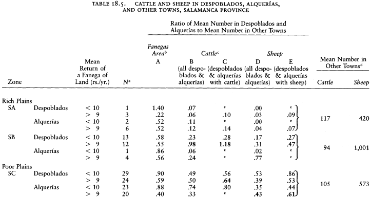
The catastro's census of livestock confirms the finding that despoblados were not especially dedicated to grazing. Table 17.4 shows that the zones with despoblados had many animals per vecino, although not as many as the mountain valleys of Piedrahita (SI) zone. The concentration of sheep and cattle was a feature of the zones, however, and not specific to the despoblados and alquerías. Table 18.5 shows that measure for measure of land, as a general rule despoblados and alquerías had fewer rather than more cattle and sheep than the more populated places. The only categories in the table where the depopulated places showed a concentration of livestock were not primarily devoted to pasturage but were involved in arable farming: in zones SB and SC such despoblados had proportionately more cattle than larger places and such alquerías had more sheep. It is significant that animal husbandry was found where there was active farming. In Salamanca at this time, specialization in breeding livestock separately from growing grain had not yet developed.[31]
We are left with a paradox. Here are tiny places, housing only one, two, or three families, existing next to towns with five, ten, or more times as many people, yet engaged in virtually identical forms of agriculture. How can one explain this? Again the catastro comes to our aid. It tells us nothing, we know, about who rented the fields and pastures or who exploited them with hired labor, only who owned them. One can, however, use indirect evidence to create a reasonably reliable picture of
[30] A measure of pasture land was seldom assigned more than 8 reales per year return, and much of it was worth only 1 or 2 reales. Poor arable that could be sown with rye every third year was about 8 to 12, with wheat somewhat higher, 15 to 20. Rich wheat land in La Mata, sown every other year, returned 56 reales, and the poorest rye land there, 24. The scale can be judged from the mean return of the towns studied in Part 2: La Mata (prosperous rich plains town, SA), 40; Villaverde (struggling rich plains town, SA), 38; El Mirón (declining sierra town, SI), 11; Santa María del Berrocal (prosperous sierra town, SI), 20; despoblados, La Cañada (SA), 23; La Cañadilla (SA), 22; Narros (SA), 22; Pedrollén (SC), 5.
[31] The catastro evaluated the actual use of land, not its potential value. A mean revenue of 10 or more reales per year in Table 18.4 could not have been achieved without considerable land actually under cultivation. It is true that despoblados with much pasture and few animals might have been rented to outsiders whose animals would have been listed under their home towns, but Table 18.4 shows that only a small proportion of the despoblados were primarily pasture.
what was going on in the despoblados. The first step is to estimate whether the residents listed in the small places were numerous enough to produce the return reported from these places.
According to my calculations, Pedrollén produced a gross income from agriculture and livestock of some 800 EFW (see Table 9.8), although some of this income was the result of pasturing animals outside its limits. The provincial summary of the catastro, however, reported its land to produce 5,685 reales, that is 380 EFW, about half what I calculated. Most of the disparity is the result of the low income that the catastro assigned to pastures. In La Mata and Villaverde, towns of the rich Armuña district, my calculations of gross income from the land are also higher than the return reported in the provincial catastro summary (1.5 and 1.2 times as great), although the difference is less than for Pedrollén, partly because there was less animal husbandry.
The wealthiest labrador in La Mata (the casa excusada) had a gross income of some 600 EFW, but at the above rate, he would have farmed land evaluated in the catastro at 400 EFW. He used five yokes of oxen, thus needing four additional hands (including any grown sons), at least during plowing. In Villaverde, where per capita income was lower, the richest labrador had a gross income of 400 EFW, and the reported return on his share of the land would be 333 EFW. These figures give us an idea of how much land, in terms of its reported harvest, a fully employed farmer could handle.
Since the alquerías and despoblados had more pasture than the towns of La Armuña and pastures were undervalued in the catastro, the gross return on the amount of land that one vecino could work would be less than that produced by the wealthiest labradores in Villaverde and La Mata. Land reported to return about 300 EFW (4,200 reales) would be the maximum for one man in the rich plains zones; in the poor plains zones, with more pastures, the limit would be lower, say 200 EFW. In despoblados and alquerías that had a higher return per vecino than these limits, one can be reasonably certain that part of the land was being worked by men from nearby towns. Of course, if despoblados and alquerías showed no vecinos at all, all the labor was being done by outsiders. For example, the despoblado of Riolobos in the rich plains (zone SB) had land producing 4,530 EFW (63,390 reales) according to the catastro summary and only one vecino. At one full-time farmer for each 300 EFW, it needed fourteen additional farmers. Cente Rubio (zone SB) had no vecinos, but with land producing 1,603 EFW, we can posit that it employed five or six full-time farmers from outside. San
Pedro de Azerón in the poor plains (zone SC) produced 620 EFW and had one vecino. It needed at least two more farmers. These calculations furnish only the roughest sort of estimate, intended to show the nature of the situation. In all likelihood outsiders who worked in the depopulated places did so only part-time, after caring for their fields in their home towns. The number of individuals involved was therefore probably much higher than the estimated full-time outsiders.
Table 18.6 indicates the situation in the five zones. One sees from the last column that the small places required more than twice as much labor as their vecinos could produce. Rather than as self-contained units, one can think of them as low-pressure areas, inadequately tended, with few or no permanent workers, which drew in peasants from surrounding high-pressure zones, towns with more than a full complement of workers. But these peasants moved in and out when the seasonal needs required their presence, returning home in the evening, leaving the despoblados again empty. These were not the cortijos of Jaén, for the workers from outside lived close enough to make the daily journey except perhaps in the rush of the harvest season. And they were not cortijos for another reason: the people who farmed them in this way were not day laborers but tenant farmers, most probably labradores with their own draft animals. They worked for their own account and paid rent at a predetermined rate. We saw some of them in both La Mata and Villaverde. There was even a local term for their plots; they were called tierras entradizas.[ 32] Not all depopulated places were farmed in this way, of course. Pedrollén, which does not figure as needing additional workers, was rented to a single tenant as one exploitation. Three vecinos of nearby towns, nevertheless, labored on it as hired help.
The permanent personnel in the small places did not have a normal demographic structure, as one can observe by comparing the population pyramids of places with less than twenty people in 1786 to those of the towns surrounding them (Figure 18.1 and Appendix T). In the four plains zones, medium-sized towns have fairly regular pyramids, although one can see a shortage of young unmarried females, gone probably to be domestic help in bigger places. The small places show a disproportionate number of unmarried males under twenty-five and few old people. Most of the people considered resident by the census takers do not appear attached to the places, many young hired hands and a
[32] The term can be found, among other places, in the royal provision on the repopulation of the despoblados, Nov. rec., VII, xxii, 9, art. 21 (15 Mar. 1791).
| |||||||||||||||||||||||||||||||||||||||||||||||||||||||||||||||||||||||||||||||||||||||||||||||||||||||||||||||||||||||||||||||||||||||||||||||||||||||||||||||||||||||||||||||||||||||||||||||||||||||||||||||||||||||||||||||||
few married couples, who would include the current large tenants like the one at Pedrollén and their wives.
Beyond these general characteristics, however, Table 18.6 reveals that not all small places were alike. For the first time alquerías and despoblados appear with different features. Over a third of the despoblados had no vecinos at all; this was true of only four alquerías. The latter, in other words, had permnanent personnel, at least a guard, the montarraz. Permanent residents also furnished a larger portion of their labor needs. With 217 vecinos for 78 alquerías, almost 3 per place, they needed only 137 additional full-time hands from outside. Despoblados barely averaged 1 vecino and needed over one and a half times as many farmers from outside. The owners of alquerías seem to have supervised their exploitation much more than those of despoblados.
There was a difference among regions too. In the rich plains north and east of Salamanca city (zones SA and SB), the despoblados needed 5 times as many outside farmers as they had vecinos, whereas in the poor plains (SC, SD) and in the adjacent hilly zone, SF, they were more nearly self-sufficient. The despoblados of the rich plains zones were scattered among relatively large towns.[33] Demographic pressure, we saw, drove the peasants of La Mata and Villaverde to break soil in neighboring despoblados. There was evidently less pressure in the poor plains.
In the 1750s, the time of our data, neither La Mata nor Villaverde had overflowed much into the despoblados; the flood would come later in the century. Asked to report on the possibility for resettling the despoblados, the corregidor of Salamanca in 1769 replied that they could support six times as many vecinos as they then had.[34] Table 18.6 estimates that in the 1750s the despoblados were employing between two and three times as many farmers as there were vecinos. The examples of La Mata and Villaverde indicate that as the century wore on, the depopulated places were accommodating more and more nearby farmers. No doubt their soil was less productive than that of neighboring villages or they would not have become abandoned, but as population grew they were being reincorporated into the overall pattern of agriculture.
In most cases, however, they were not being repopulated, only recultivated. Events of earlier centuries had concentrated the population in fewer units. The units were now growing and expanding their radius
[33] Excluding despoblados and alquerías, the mean town size in the zones was rich plains, SA 300, SB 310; poor plains, SC 140, SD 170; SF 240.
[34] The report dealt with the whole province, including the partido of Ciudad Rodrigo (García Zarza, Despoblados, 91 and Table, 143–47).
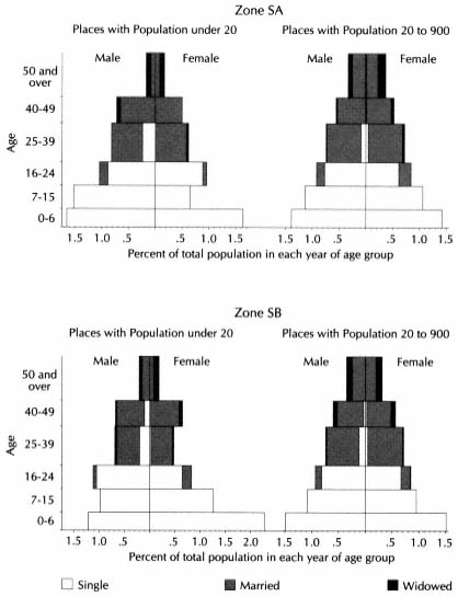
Figure 18.1.
Salamanca Plain, Population Structures of Small
Places and Medium-Sized Towns (see Appendix T)
of cultivation rather than undergoing fission. The regions of deserted villages in France experienced the same phenomenon.[35] It would be tempting to ascribe the choice to the peasants themselves, kept in their
[35] Pesez and Le Roy Ladurie, "Deserted Villages," 85. See also Cabo Alonso, "La Armuña," 393–94.

NOTE : Since there is no limot to the top age group, a
span of seventeen years is used for convenience only.
native villages by the charms of social intercourse, but the economics of the situation suggest another explanation.
The mean productivity of labor was far higher in the despoblados than in the villages. The estimate used above for production on the despoblados and alquerías was an average return to labor of 300 EFW per man in the rich plains and 200 EFW in the poor plains. The overall
gross return from land per vecino engaged in agriculture in the rich zones was 110 EFW and in the poor zones 60 EFW (including residents of populated and depopulated places). The difference is impressive. One might object that the estimate for return per farmer in the depopulated places is excessive (although, if it is, they needed even more outside labor than deduced above). An easy calculation will respond to this objection. One can compare the mean return per measure of land and the mean income per vecino engaged in agriculture in the nine zones of the province (Table 18.7). The results reveal a striking fact. The mean return of a measure of productive land is related to the geographic characteristics of the zones, as one might expect. The rich plains zones had land of high return per measure, the poor plains zones a low return. The sierra zones were also high, in part because of the high value of crops like flax, and the hilly zones were intermediate. But the income per vecino engaged in agriculture does not correlate with the productivity of the land. The five zones with a large number of despoblados and alque-
| ||||||||||||||||||||||||||||||||||||||||||||||||||||||||||||||||||||||||||
rías have the highest readings in per capita income, although they include the three zones with the poorest soil. It seems correct to conclude that despoblados and alquerías raised the mean productivity of agricultural labor in these zones because the productivity of farmers was greater here than in the neighboring towns, thus reinforcing the assumption made above. One can recall that Pedrollén had the highest per capita income of all our towns, though little went to the laborers.
One might be led to conclude that alquerías and, especially, despoblados were a boon to the vecinos of nearby towns, who could expand their income on land where the marginal productivity of their labor was higher than that in their towns. On the other hand, the Ricardian model we found applicable to individual towns in Part 2 would postulate that the excess return from the depopulated places would go to the owners, who could benefit in high rents from the competition among prospective tenants. As population increased in the towns and exploitations became subdivided by inheritance or new leases, young farmers would be looking for any solution to the economic squeeze. They would pay high rents for entradizas, even though these required a greater input of their own and their draft animals' time in travel. In Part 2 we concluded that the rent for Narros jumped 50 percent in three decades as the town councils of La Mata and Carbajosa de Armuña competed for its use.[36] Nearby, the vecinos of Villaverde paid about 38 percent of the harvest as rent in the despoblados of La Cañada and La Cañadilla at midcentury, whereas the rent for land in Villaverde was about 31 percent of the harvest, itself a high rate.[37] Rents kept going up, but harvests did too. Our information on harvests is sporadic, and the ratio of rent to harvest in any specific year depended greatly on the size of the harvest. In 1789 the ratio for these despoblados was 34 percent; the rent established for La Cañada in 1803 was 37 percent of the good harvest in 1801 (1803 was a famine year). In 1805 rents were lowered, harvests were good, and the ratio for La Cañada and La Cañadilla together was 22 percent.[38] One gets the impression that owners and tenants were agreed on a rent equal to 35 to 40 percent of the harvest, higher than any recorded in the towns. Owners clearly gained, but peasants in the rich zones might get more return for their labor too, since per capita harvests were two to three times as high in the despoblados, if my earlier reasoning is valid.
[36] See above, Chapter 7, section 7.
[37] See Chapter 8, section 1, and Table 8.10.
[38] From above, Chapter 8, section 5, and the Villaverde tithe register (AHPS, Hacienda, libro 167).
In the poor zones some labradores faced rack rent, to judge from complaints to the crown.
These examples on the whole support the Ricardian model. Although peasants who succeeded in getting leases to despoblados received a greater marginal return for their labor than they did in their villages, especially at the end of the century when inflation raised the price of their harvests, most owners exerted themselves to siphon off any excess per capita income, once the rigidities of the situation were overcome. This fact explains why peasants did not move into the despoblados: the owners did not let them because they sensed that a permanent settlement would soon reduce the marginal productivity of labor and the share the owner could extract.
We can now understand the economic motivation behind the creation of despoblados. A corollary of this conclusion is that a larger share of the production in the despoblados and alquerías reached the national market than in the adjoining towns. Whether the tenants paid in grain or sold grain and animals to pay in currency, more of their harvests and livestock were diverted from local consumption. Despoblados monetized and commercialized agriculture. No doubt they had been doing so since they first appeared at the end of the Middle Ages.
4
The complaints of extortionary rents in Salamanca and other provinces that reached the crown in the 1760s roused the interest of the royal counselors. In 1769 the corregidor of Salamanca surveyed the situation under his jurisdiction. From the replies to his questions, he drew up a list of 202 "despoblados," among which he included alquerías and even a number of lugares and several villas, all of which he judged to fit within the meaning of the term. He reported 302 vecinos living in them but said that they could support 1,692 vecinos, if properly resettled. His estimate was surely optimistic; in some places he proposed settling 30 to 70 families, and he apparently did not make clear that much of the land was being tilled by residents of neighboring towns who would have to be among the settlers or lose their leases. He responded, no doubt, with what he believed his superiors in Madrid wanted to hear.[39]
Carlos III at once appointed a superintendent for the resettlement of
[39] García Zarza, Despoblados, 91–92. Pages 142–47 give the corregidor's table. I have not been able to locate all his despoblados. Most fall in Zones SA, SB, and SC.
despoblados in Salamanca province,[40] but before any concrete steps were taken the Conde de Aranda was sent to Paris as ambassador, Olavide fell, and the project languished. A royal cédula of 1781 revived it, establishing juntas de repoblación (resettlement boards) in Salamanca and Ciudad Rodrigo. The first consisted of the royal corregidor, the alcalde, and other representatives of the city. A further order of 1784 spelled out the procedure the juntas were to follow.[41] One can see the hand of Campomanes behind the project. He had recently become president of the Mesta, and he was using his position to weaken the restrictions that sheep, raisers enforced on the use of the land. The cédula stated that resettlement would eventually return to farming all land that had once been arable. To prevent a future reversion to pasture, the cédula put strict limits on the use of the land.
According to the regulations, settlers (colonos) would get enough arable to plant 22.5 fanegas a year, this being considered what a yoke of oxen could plow. The actual extent would depend on the number of years in the local crop rotation. The plots would be designed as large as possible, while giving each settler equivalent amounts of different qualities of land (what is now called parcellary concentration was already in the minds of the royal planners). The new colonists would also get the use of pastures and waste, but pastures not required by the colonists would be left to the graziers. In keeping with all Carlos III's projects for internal colonizing, strict rules prevented the union of different holdings or their exploitation by outsiders. Impartial experts would determine how much rent each settler or grazier would pay to the owner, but the total rent currently being received for a despoblado could not be increased. Each settler was required to build a house within two years and pay the owner a small permanent quitrent (canón ) for it in addition to the rent of his land. Although the owners kept title to the despoblados, control over the renting and use of the land was taken out of their hands. Most large owners, either noble or clerical, would have their property in entail. The reform did not break the entail of despoblados, but it created an overriding entail of a different kind.
The royal reformers aimed to avoid the Ricardian trap by fixing the rent and the Malthusian trap by keeping the lots at family size, but in doing so they created a rigid system that was bound to hinder economic
[40] RC, 28 Nov. 1769, cited in ibid., 89.
[41] Nov. rec., VII, xxii, 9 (15 Mar. 1791), repeats this RC. See García Zarza, Despoblados, 95–98.
development. If the harvest on a fanega of land averaged about 4.5 fanegas of wheat, as in Pedrollén, a labrador would collect about 100 fanegas of wheat a year, gross. Seed, tithes, and rent would bring this down to between 50 and 65 EFW, a bare minimum for a family of five. On better land, the return would be higher, but the project, even under favorable conditions, would severely limit the contribution of the colonos to the national market. The owner's share would still be commercialized, but it would not increase as new land was put under the plow. The ideal of the reformers was to turn despoblados into ordinary villages; we have just seen that this meant reducing per capita production and the proportion going to the owner and to the market. In the long run there was little in it even for the peasants. The reformers might try to exorcise Ricardo; they had no way to expel Malthus.[42]
A number of candidates applied for settlement in various despoblados, but few achieved their wish. Those who benefited from existing conditions maneuvered to gut the program. Owners labeled the process confiscation (despojo ), appealed to the courts, and directed threats at prospective colonists. Towns whose vecinos already farmed the despoblados joined in the complaints, while the large graziers worked behind the scenes to dissuade the juntas from taking action. In 1787, after years of petitioning, the sexmeros of the partido of Salamanca were given a vote in the junta. One from each of the four cuartos of the partido, they were elected biennially by the alcalde and one regidor of each town together with the large tenants of the alquerías and despoblados. They represented the existing exploiters of the land rather than the owners, but they too spoke in opposition to resettlement, arguing that the proposal had been conceived without attention to local conditions. Many despoblados did not have sufficient arable land to support a new town, they insisted correctly.[43]
The extant records of the operation indicate that the junta de repoblación in Salamanca sent the Council of Castile proposals for resettlement of forty-eight despoblados and alquerías. At least twenty of them in our study area were selected for colonizing along with five other small places not officially despoblados or alquerías.[44] Miñano shows that twelve of these actually registered some growth in population by
[42] García Zarza observes that the niggardliness of the concessions virtually condemned the reform to failure (ibid., 98, 124).
[43] Ibid., 93–95, 111–12, 126–32.
[44] Ibid., 102, 105–6, 110–11. García Zarza does not name the places. See also Cabo Alonso, "La Armuña," 394.
1826, but four other despoblados and alquerías also grew without royal resettlement. In all, though, only six of these places added more than thirty people by 1826; Narros de Valdunciel, bordering on La Mata, was one of the largest. Three in the rich plains zones, including Narros, had high incomes at the time of the catastro, indicating that they were being farmed by vecinos of nearby towns, who may have moved into them as those of La Mata did into Narros. The other three, in poor plains zones, appear to have been underexploited at midcentury, and the growth represented inmigration of families not previously associated with them. None of these three was officially a despoblado or an alquería.[45] Most of the other places targeted for resettlement had lost their population in the eighteenth century. The conditions that had recently turned them into despoblados—either the nature of their economy or the pressure of their owners—could not be easily reversed.
Although the creation of six viable towns (and a seventh in the partido of Ciudad Rodrigo)[46] was not a negligible accomplishment, both contemporaries and later writers have looked on the effort as a failure. The information developed above indicates that the objective of turning despoblados into prosperous villages was unrealistic. Most of them lacked an adequate base for an independent community—one of the main reasons the population had declined in the first place—and to a greater or lesser extent they had become integrated into the economies of neighboring villages, which needed their resources. As we saw, most despoblados and alquerías were no more devoted to pasture than the villages around them. Whatever they might have been in the seventeenth century, they were not now grazing reserves kept from more productive use by the Mesta or other livestock interests.
Few despoblados and alquerías became new villages, but the population of the others was not stationary. The censuses indicate that the number of people living in them was on the rise, although a clear distinction appears among the zones (Table 18.8). In the rich plains (SA, SB) and Ledesma zone (SD), the number of vecinos in the depopulated places grew markedly—between 50 and 100 percent—in the threequarters century after the catastro, far outstripping the overall growth of these zones. In Charro zone (SC) and the adjoining hilly Salvatierra zone (SF) the small places hardly grew at all, yet the zones experienced a
[45] Villanueva de los Pabones (Zone SA, pop. in 1826, 82); Narros (SA, 60); Riolobos (SB, 38); El Tejado (SC, 50); Canillas de Torneros (SC, 48); Carnero (SC, 40).
[46] Fuenteliante, see García Zarza, Despoblados, 108–9.
| |||||||||||||||||||||||||||||||||||||||||||||||||||||||||||||||||||
relatively rapid growth. (After 1826, one no longer has separate population figures for despoblados and alquerías because they were incorporated into adjoining towns.)
A comparison of this pattern with Table 18.4 reveals that the two zones whose despoblados and alquerías showed little population growth were those where these places had the poorest land, primarily pasture and poor arable. The plains of Salamanca and the adjoining hills of Salvatierra were splitting into two different lines of evolution. In the rich grain land north and east of Salamanca city, people were moving into the despoblados, creating a more equal spread of population across the countryside, although the numbers were too small to establish new nuclear villages. In the poor zones, population growth, which was proportionately faster at this time than in the rich zones, took place in the existing towns, increasing the contrast between town and despoblados. The experience of Ledesma zone (SD) lay between these two patterns. Despoblados and alquerías had been a feature of all the plains; developments in our period were making them typical only of the poorer plains and adjoining hills of shale. Since the nineteenth century, the additional contrast has developed that these former despoblados have become pri-
marily devoted to livestock, vast expanses featuring live oak groves and known familiarly as dehesas. This was not the situation in the eighteenth century; it appears to have developed in conjunction with a sharper distinction between private estates and land-hungry villages.[47]
5
The juntas de repoblación limped on into the 1790s, without effecting new settlements. Several times their members, many of whom were sympathetic to the groups currently exploiting the despoblados, expressed the wish to be disbanded, adducing that the regular provincial officials could carry on their task adequately. Finally in July 1801 the king dismissed the junta of Salamanca. That of Ciudad Rodrigo lived on, inactive, until 1816.[48] By 1801 the disentail of Carlos IV was in full swing, pointing the future of the despoblados in a radically new direction. Campomanes and his collaborators wished to keep the entails that bound the despoblados but break their effect by forced colonization. The juntas found such strict regulation unattractive and unworkable; their response promised a warm welcome to a policy that would let the land market determine their future. Under the decrees of September 1798 those portions of despoblados and alquerías that belonged to obras pías and related ecclesiastical foundations became liable to sale at auction.
Within a scant decade, the disentail affected many more despoblados than the juntas had modified in twice that time, for the groups that had opposed resettlement were eager to take advantage of the sales. The records preserved in Madrid show disentail involving forty-six despoblados and alquerías. Thirteen were sold in their entirety, and shares of twenty-five others, ranging from 4/43 to 6/7 (the median is 1/3). In eight more places the disentail involved individual fields and a house. About one-seventh of the despoblados and alquerías shown in Table 18.1 were affected, with the highest proportions in the rich plains zones, SA (17 percent) and SB (15 percent). One full término redondo and shares of three others, all still officially classified as lugares, also went on the
[47] García Zarza's title and text imply that the despoblados were dehesas in the eighteenth century. Cabo Alonso, "Antecedentes históricos," 87–88, also seems to depict the despoblados as vast pastures in the eighteenth century, although their owners did not own the livestock. He believes in the next century the landowners also became the livestock owners.
[48] García Zarza, Despoblados, 132–34, citing real provisión of 24 July 1801.
block.[49] Since many of the early sales were not recorded in Madrid, the disentail undoubtedly touched more places than these. Even in the Madrid records, a disproportionate number of the sales of entire despoblados occurred in the first years: half in 1799 and 1800. Both the crown and the buyers found them tempting, the crown because their disposal provided a rapid influx of currency for a minimum of paper work, the buyers because their administrative costs were low and the owner's share of the return high.
The affected despoblados fall into two distinct groups, and so do the people who bought them. The most common sale was of an entire despoblado or alquería, or of a share in one of them. In either case, the description of the property indicates that it was exploited as a unit, that is, that it was a término redondo. Thirty-five of them were far smaller and poorer than the average. At midcentury their mean annual return was under 500 EFW, with only six producing over 600 EFW. Those that were sold as a single unit, that is, those that had previously belonged to only one owner rather than a consortium, were especially small.[50] Nor did they have much potential for growth. I estimate that at midcentury the thirty-five places needed only forty-seven outside farmers. Further breaking of ground would occupy more men, but the small size and inferior quality of the land set limits that would be quickly reached.
The data from the catastro do not show términos redondos to be smaller than other depopulated places. Why then were those sold off so little? The answer is that obras pías and related ecclesiastical institutions were part or full owners of places that were below average in size.[51] One can only guess that in making bequests to charitable and religious funds, property owners over the previous centuries had contributed their less valuable holdings. For our purpose the discovery means that the sales of Carlos IV touched the small end of the distribution of términos redondos, not a random sample of the phenomenon.
[49] The places sold in their entirety, with the number of the Madrid deed, were SA, Arroyo: A1156 (1799), Cañedino: C12687 (1802), Tesonera: A2869 (1800); SB, Lagartera: A609 (1799), Revilla la Alta: C45113 (1806); SC, Agustines: A4002 (1800), Alizaces: A11880 (1803), Porquerizos: A5767 (1800), Tabaruela: A5767 (1800); SD, Contiensa: A11091 (1802), Noguéz: C31879 (1804), Valderas: C1427 (1800); SE, Vidola (lugar): A11882 (1803).
[50] Their production averaged only 400 EFW, and their area was well below the normal size of despoblados. Mean size of términos redondos sold as a single unit: SA 170 hectares (N = 3), SB 102 hectares (N = 2), SC 258 hectares (N = 4), SD 360 hectares (N = 3). Compare Table 18.2.
[51] The despoblados identified by the catastro as owned entirely by obras pías and related institutions had the following mean size: SA 80 hectares (N = 2), SB 440 hectares (N = 5); SC 245 hectares (N = 7), SD 120 hectares (N = 4). Compare Table 18.2
In eight despoblados and alquerías individual plots were sold, implying that they were not términos redondos. They were not typical either, for they were at the other end of the spectrum. Zaratán (zone SC), in which a huerta was sold, although classed as an alquería, had twenty-eight people in the census of 1786. With 950 hectares and an annual product of 1,200 EFW at midcentury, it was far more populous, extensive, and productive than the ordinary alquería. Narros was even bigger, richer, and after the resettlement of 1789, more populous. As a group these eight places had active economies in 1750. Their mean annual return was 1,700 EFW, and only one produced less than 600 EFW. Only this last needed no outside labor; the other seven had twelve vecinos and, by my estimate, required the labor of forty nearby farmers.[52]
Disentail provided the opportunity for individuals to establish themselves as farmer-owners in them, something the royal colonization had failed to do. The kind of person who rented tierras entradizas now took the opportunity to buy them. Two vecinos of La Mata fit this description, Josef Rodríguez and Julián Gómez, who joined forces to buy some fields in Narros.[53] It is hard to identify such people in the Madrid records because the deeds seldom give their residence. Gabriel Gómez, who purchased eight fields in the despoblado of Malpartida (SC), could have been a nearby labrador, for he was not called don. Antonio Angozo was a vecino of Zaratán, where he bought the huerta mentioned above and a house.[54]
The people who bought entire términos redondos or shares in them were quite different. The majority belonged to the top level of buyers and had no intention of farming themselves. They were addressed as don and lived at a distance, half of them in the city of Salamanca, three in Ledesma, cabeza de partido, a few in other big towns, three outside the province. They bought not to farm but to invest, letting others do the dirty work. Most of these individuals will appear again in the next chapter on big buyers, so we need pursue them no further here. With them were some lower-ranked buyers, about whom we can tell very little. Nine made only one purchase, acquiring shares in various términos redondos, all located in the poor zones, SC, SD, and SF. Two men and a woman lacked the don or doña. Not large investors in disentail, they chose to become partners in ownership of a despoblado, where,
[52] These places were SA, Narros; SB, Castañeda, Pinilla, Revilla de Cantalpino, Sordos; SC, Malpartida, Pedro Martín, Zaratán.
[53] C28355, C29393. See Table 7.24.
[54] C21233, A7552.
since they were minor shareholders, the burden of administration would lie in other hands.[55] Others in this range, five men and one woman, made more than one purchase, usually acquiring arable plots as well as shares in despoblados. Buyers interested in términos redondos came from all kinds of social and economic categories. They resembled each other only in that all had money to spend and chose a despoblado as a sound investment.
6
Today as one travels southwest from Salamanca through the Charro district or west past Ledesma toward Vitigudino, one is struck by the welltended dehesas with their neatly trimmed live oaks, their stone walls, and their herds of black cattle. Most of these, as the students of Salamanca point out, were despoblados in the eighteenth century.[56] There is a tendency to read back the present situation and think of the despoblados as estates devoted to livestock throughout modern times, providing riches for idle absentee owners. The protests directed to Carlos III by owners of large herds who rented despoblados reinforce this image. They show, however, that in the eighteenth century, the ownership of land and livestock was in separate hands; today the landowner is also proprietor of the cattle. Cabo Alonso has proposed that disentail permitted tenants to acquire the property and thus unite land and livestock in the same hands.[57] The information developed here suggests a different course of events. In the eighteenth century there was little specialization in most despoblados. They produced grain and raised cattle and sheep as a secondary activity, differing little from the towns around them. No perceptible change had occurred by the end of Carlos IV's reign or, according to information developed by Cabo Alonso, even by the time Mendizábal revived disentail in the 1830s. In our deeds of disentail the term término redondo is applied to sixteen places, dehesa to only three, all of them in the rich plains zones, not the primary area of today's dehesas.
Specialization in livestock and the development of the live oak dehesa would appear to be a development of the nineteenth century, an economic response to urban growth and the railroads.[58] It corresponded to
[55] A2719, A4534, C18271, C21844, C24826, C51294, C53903, C53970, C59214.
[56] Cabo Alonso, "Antecedentes históricos"; García Zarza, Despoblados.
[57] Cabo Alonso, "Antecedentes históricos," 75–76, 88.
[58] Little is known about the course of livestock production in the nineteenth century. See Vicens Vives, Historia 5 : 240–42.
the extension of olive groves in Jaén. Both involved production for the market based on the exploitation of comparative factor advantages, which deemphasized arable farming. Olive groves in Jaén and pasturage in the poor plains of Salamanca had long traditions; the change represented a new emphasis, not a new departure. The evidence available for this study indicates that the extension of olive cultivation began in parts of Jaén before the catastro and spread to other zones in the second half of the century. In Salamanca it would appear that the turn to pasturage took place during the demographic lows of the late Middle Ages and the seventeenth century, with an emphasis on sheep. In the eighteenth century there was a recovery of arable farming, only to be followed in the nineteenth by a return to livestock, this time directed not at the market for wool but for meat, and secondarily for fighting bulls.[59] Owners took over the management of the operation, expelled the tenants, and acquired livestock.
Economic forces, not the disentail, were primarily responsible for the change. Did the disentail of Carlos IV play any role? In the long run, no doubt it did. It took property away from religious foundations and put it into private hands, which were looking for income and would perceive the advantages of change when the time came. More important, it broke the entail on these properties. When the process was completed by the abolition of vínculos and mayorazgos in 1836, the division of términos redondos into fixed shares would be unfrozen. One active owner could now buy out his partners and exploit the property aggressively. We know very little of the details of the process, however.
The reform of Carlos III did not work because it conflicted with established interests and current practice at all levels. Disentail did work because it joined crown and active economic forces in common objectives. Has the result been bad? Certainly there would appear to be more social justice in a prosperous peasantry than in well-kept estates enriching absentee owners. Carlos III's advisers considered the despoblados a social and economic evil, and they sought to fulfill their own ideal of independent farmers. Historians too have judged the persistence of the despoblados and their evolution into the modern dehesa a cause of social and economic injustice.[60] One of the major reasons for Spain's failure to industrialize in the nineteenth century has been found in the lack
[59] On the raising of fighting bulls, see Cabo Alonso, "Antecedentes históricos," 90.
[60] García Zarza takes this position strongly, although he recognizes the unsuitableness of many despoblados for resettlement (Despoblados, 88). Domínguez Ortiz also finds persistent bad effects in the despoblados ("Ruina de la aldea," 110).
of an adequate market among the rural population, in turn blamed on the unequal distribution of land.[61] We have seen that the income from the land per vecino in agriculture was highest in the zones that had despoblados. If this income had not gone to absentee owners, logically it would have raised the purchasing power of the peasants. According to the accepted line of reasoning, the wealth that flowed to the absentee owners might have been economically justified if it had been invested in productive enterprises, but most of it was wasted, economically speaking, in conspicuous living, at best supporting specialized crafts and importers of foreign luxuries. When the landowners invested, they put their money into the purchase of more land, attracted by the desamortización, rather than into improvements in land already owned. This capital ended up in the hands of the state, which paid off its creditors rather than using it to create a suitable infrastructure for economic growth.
One can question this interpretation, however, on the basis of developments in Salamanca, because the province had regions both of large properties and of a prosperous peasantry. Nowhere, of course, have we found in the eighteenth century the private farmer owning his fields or enjoying a guaranteed exploitation of the land, as desired by the reformers, but the peasants of the rich plains zones received more than the minimum needed for subsistence, in some cases a good deal more, to judge from our studies of La Mata and Villaverde. Return from the land was high (Table 18.7), and custom limited the rents. Many vecinos took advantage of the disentail to buy land. If any peasants were to provide a market for industry, these should be they. In contrast, large properties predominated in the poor plains zones and hilly Salvatierra zone. Although the output per vecino in agriculture was not so high as in the rich zones, it was higher than in the sierra zones. Here, however, the Ricardian trap on lands that had no customary rent drove down the income of the peasants, as evidenced in Pedrollén, where only the tenant had a respectable income. These peasants were a less promising market for industry. A comparison of the two examples should bear on the case at issue.
The only statistics readily available for comparison are population figures, and they tell us little (Table 18.9). All regions grew in population between the censuses of 1786 and 1857 and between 1826 and 1857. The rates of growth reveal no patterns that can be clearly associated with either geography or agricultural economy. The rich plains
[61] See, for example, Jordi Nadal, "Failure of the Industrial Revolution."
| ||||||||||||||||||||||||||||||||||||||||||||||||||||||||||||||||||||||||||||||||||||||||||||||||||||||||
would appear to have been growing faster than the poor plains between 1786 and 1826, but the pattern is reversed between 1826 and 1857. One might argue for some exogenous explanation—the Napoleonic war, for example—or one may simply suspect the accuracy of Miñano's figures for 1826. Even if a consistent pattern were to appear, however, one cannot know whether population growth was a sign of prosperity or was producing a Malthusian squeeze on resources, as it did in La Mata in the late eighteenth century.
A greater indication of the economic effect of the nature and size of exploitations may be deduced from the demographic behavior of the local urban centers. If the countryside were furnishing a market, it should
have spurred the growth of the centers of distribution. The main ones were the cabezas de partido. Salamanca city was the economic focus for most of the plain. Its population declined in the quarter century after the disentail of Carlos IV and still had not recovered its 1786 level by 1857 (Table 18.9). The first census that shows a larger population is 1877. Alba de Tormes, which shared the leadership of the rich plains with Salamanca, grew much more slowly than its zone. On the other hand, Ledesma, capital of a poor plains zone with despoblados that evolved into dehesas, grew more rapidly than its zone. Obviously the rate of population increase depended on many variables, but there is no indication that the rich plains of Salamanca offered a rural market that might have decisively supported an industrial revolution.
The sierra zones provide another check. The return from the land per vecino in agriculture was low, but the land was mostly in local hands, and disentail increased the peasants' share of it. Patterns of land purchase showed a more egalitarian society and less involvement in the market, despite the production of wool and flax. Even a casual visit to the area reveals houses in the towns and villages that betoken former prosperity, and dates on lintels indicate the period of the construction of many to be the eighteenth and early nineteenth centuries. In the nineteenth century, these areas appear to have planted their linen fields with potatoes, increasing food production but not marketable income.[62] Despite this apparent well-being, the peasants provided little market for outside goods, to judge from available indications. With the exception of Béjar, which enjoyed a manufacturing boom, the cabezas de partido did not keep up with local population growth.
This line of reasoning, admittedly inconclusive, does not support the theory that Spain had the potential for an industrial revolution based on a peasant prosperity that could come from a wide distribution of land. A more tenable argument can be made that the términos redondos and the dehesas they evolved into, by specializing in animal husbandry, offered an economic stimulus. Even if the owners invested none of their income in productive enterprises (a fact that is assumed rather than known, some may have bought railroad stock, while the mere fact of creating dehesas involves some investment in the land), their role may have been beneficial. By drawing income from the countryside to the city, they encouraged urban growth. Economic historians have distinguished between cities as engines of growth and parasitic cities that suck
[62] Cabo Alonso, "Antecedentes históricos," 89.
the surplus from their hinterlands through tithes, rents, and feudal levies. Madrid has been identified as the prime example of such a parasite.[63] Although most of our big buyers, the purchasers of despoblados, lived in Salamanca city and other places nearer than Madrid, their role fits that of an elite fueling parasite cities.
Recently, E. A. Wrigley has questioned whether any city could play the role of parasite. Even though the per capita income of peasants might increase momentarily if the exactions of cities were suppressed, he argues cogently, the real issue is not the immediate result but the potential for growth in the future. "To consume the surplus in the countryside, rather than surrender it for consumption in cities to meet the needs of a ruling urban elite, is no doubt gratifying to those whose bellies are filled as a result, but it is reasonable to view it as a small matter where the surplus is consumed, and a much more serious matter that it is disposed of, whether in town or country, in a way which makes it improbable that the next generation will be any better clad, housed or fed than the present."[64] In preindustrial economies, specialization of function was the primary means of increasing total production; it was replaced later by technological advance. For specialization there must be transport. The cities offered the needed market to stimulate improvements in transportation and agricultural specialization and thus lay the basis for industrial growth. To pursue Wrigley's argument further, "As Adam Smith emphasized . . . the ultimate source of most wealth remained the land and the most effective way of ensuring that the investment of capital added to productivity was to invest it in agriculture. It was because the growth of towns helped to liberate more fully the productive capacity of the countryside that their growth was important. The existence of towns made it both feasible and sensible for agricultural producers to specialize."[65]
The argument can readily be extended to the case at hand. In the despoblados and the dehesas that replaced them, the owners cut as big a share as they could from the pie, and most of this entered the market. To increase the number of tenants would have reduced the owners' slice and retarded specialization, and a reparto would have gone even further in this direction. The owners must have sensed as much when they fought Carlos III's attempt to settle farmers on despoblados. By con-
[63] Ringrose, "Perspectives," 77–81; Ringrose, Madrid and the Spanish Economy, chap. 13 (esp. 324).
[64] Wrigley, "Parasite or Stimulus," quote on 298.
[65] Ibid., 301.
trast, in their own way, the peasants of La Armuña obtained their reparto. By the twentieth century the arable plots had passed into their hands, and even several alquerías had been sold to groups of peasants. Absentees had found more profitable uses for their capital.[66] But these peasants, who looked so promising, did not produce a market for industrial goods. Rather, their wheat monoculture, cultivated with increasingly outmoded technology, depressed them into economic dependency on the advanced regions of Spain.[67] They suffered also from the grip of Malthus, as had the medieval settlers of the future despoblados and as any new settlers would have done, whom a reparto of despoblados in the nineteenth century might have produced. Desamortización of the despoblados proved to be a more effective engine of economic progress than the luckless reforms of Carlos III. The Ricardian trap can appear more unjust than the Malthusian trap because it is inflicted on the peasantry by identifiable individuals whose power and style of life arouse our sensibilities, but considered dispassionately it is more favorable to the ultimate improvement of society and no more painful. The way to exorcise Malthus was through Ricardo, and then both could disappear.
[66] Cabo Alonso, "La Armuña," 376–78, 401–3, 411. This is a truly fine study of the evolution of our "Armuña zone."
[67] See Sánchez Albornoz, "Castilla en el siglo XIX."