V
The Stadium
As of this writing, the Stadium is not normally open, and visitors must petition the guards to accompany them. The easiest approach to the Stadium is made by retracing the route of the museum access road south to the main asphalt road and turning left (east) onto it. After two turns of the road, the first left and the second right at a modern wayside shrine, there is a gate. The road that bisected the ancient Stadium (Fig. 61) was cut and excavation beneath it begun in May 1989.
Visitors, after leaving the modern asphalt road and proceeding to the crest of the ridge west of the Stadium track, may wish to pause at the bench for a good general view of the Nemean Stadium, which was excavated from 1974 to 1981. The Stadium was created by taking advantage of a natural amphitheater between two ridges which extended north from Evangelistria Hill. The earth removed in hollowing out a semicircle at the southern end was dumped at the northern end, creating an artificial terrace approximately 8.25 m. high for the northernmost third of the racetrack. The track originally extended 600 ancient feet, a measurement standard in Greek stadia.[103] A retaining wall, however, was not built to
enclose the fill of the terrace.[104] The northern end of the Stadium consequently eroded long ago, and the northern end of the ancient track is missing.
The major elements of the Stadium, including the vaulted entranceway on the western side of the track and the water channel around its periphery, date from the late 4th century B.C. (see pp. 185-86).
From the bench the eastern side of the track to the north is visible, including the water channel—a characteristic feature of ancient stadia—constrncted of fairly hard poros limestone, which supplied athletes and spectators with fresh drinking water.[105] One of the stone settling basins placed at intervals along the water channel is also visible, as well as a stone pillar which marks the 400—foot point from the starting line.
The Track
At the bottom of the slope on the western side of the race—track a row of reused stone blocks was discovered less than 1.00 m. west of the stone water channel and essentially parallel to it. Some of these blocks retain traces of "ice-tong" lifting holes.[106] This row of blocks, approximately 0.08-0. 10 m. lower than the water channel, was a sidewalk. Stratigraphic and numismatic evidence indicates that both the sidewalk and the stone water channel were constructed in the late 4th century B.C.[107] The lower area between the sidewalk and water channel functioned as a storm drain to carry off rainwater.
[104] See Hesperia 51 (1982) 36-37.
[106] See p. 60 for the original use of such blocks in the Early Temple of Zeus.
[107] See Hesperia 46 (1977) 26, and Hesperia 49 (1980) 202-3.
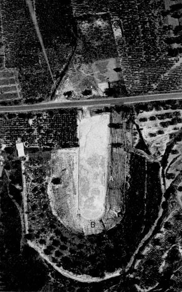
Fig. 61.
Aerial view of the Stadium, 1980: A = Judges' stand;
B = "Water closet"; C = West end of tunnel.
Immediately north of the path of the visitor who descends to the racetrack is a stone settling basin in the line of the water channel. Although no ancient source explicitly indicates the purpose of such basins, it seems reasonable to believe that in them dirt and debris settled out of the water flowing along the channel. They may also have provided drinking water for athletes and spectators. Several settling basins in the Stadium preserve traces of the red hydraulic cement with which they were originally coated, as do many of the blocks of the water channel itself.
A meter or so north of the settling basin is a 0.27 m. square stone pillar, broken across the top, marking the 300-foot point from the starting line.
The track surface itself is hard-packed gray-green clay, but it has been covered over with sand in recent times to protect it from the weather. To prepare the track for the Nemean Games and to maintain its level below that of the water channel, the track surface was dug up, leveled, and rolled every two years. This practice is attested at other sites, including the Stadium at Delphi.[108] Thus the track surface was maintained at the same height from the time of the Stadium's construction in the late 4th century B.C. until the second half of the 4th century after Christ, the latter date based on ceramic and numismatic evidence.[109]
On the eastern side of the track are the water channel, water basin, and 300-foot marker, all of which correspond to those on the western side of the track, although the marker on the western side is better preserved than its counterpart. East of and parallel to the water channel are a few scattered limestone blocks, their purpose uncertain. They may have
[108] For the 3rd-century B.C. inscription that records preparations for the Pythian Games, see J. Pouilloux, "Travaux à Delphes à l'occasion des Pythia," BCH suppl. 4 (1977) 106, lines 23-24. Pickaxes and, to a lesser extent, rollers are frequently depicted in athletic scenes in vase painting.
[109] Hesperia 47 (1978) 84. That the track stayed at more or less the same level does not imply that it was being used for games. There is no evidence for games at Nemea after the 3rd century B.C.
served either as the foundation for a wooden judges' stand or as a short row of proedria , "front-row seats," for important visitors to the Nemean Games.
South along the eastern edge of the Stadium track is another settling basin as well as a stone pillar. The pillar, which has a counterpart on the western side of the track, marks the 200-foot point from the starting line and shows that originally these markers rose some 0.45 m. above the Stadium floor. The shallow hole on the top surface indicates that some further element was carried on the marker. Immediately east of the marker and parallel to the water channel a strip of reddish earth, now covered over, was found. This represents the decomposed remains of a terracotta water channel which turned a meter or so south of the 200-foot marker and cut through the stone water channel. The path of this terracotta channel also cut across the racecourse to the west and through the surface of the track and then was routed into the vaulted entrance tunnel, passing through a "homemade" settling basin (see p. 36). These features clearly indicate that it was constructed when the track and the stone water channel were no longer being used for the Nemean Games. Although the precise date of these developments is uncertain,[110] evidence discovered in the entrance tunnel indicates that the water channel had been constructed by the mid 1st century after Christ at the latest (see p. 186 and n. 128). It provided water for some unknown purpose outside and west of the Stadium.
Further south along the eastern edge of the track is a row of squared stone blocks that begins approximately 25 m. from the 200-foot marker and is set against the stone water channel. Ceramic evidence indicates that these blocks, as Well as the contemporary water channel, date from the second half of the 4th century B.C.[111] Immediately east of the water channel, parallel both to it and to the row of stone blocks, the re-
[110] Hesperia 49 (1980) 200-201.
[111] Hesperia 46 (1977) 25.
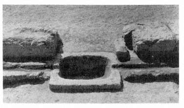
Fig. 62.
Judges' stand, basin, and socket for 100-foot marker, from the east.
mains of a mud-brick wall, now covered with earth, were discovered along with several iron and bronze nails and pins; the mud-brick and stone blocks probably supported a raised wooden platform that served as a judges' stand.[112]
Situated in the line of stone blocks is another stone Settling basin. The block immediately north of it has a 0.28 by 0.12 m. rectangular cutting in its southeastern corner (Fig. 62). This cutting, which held the 100-foot marker, is 29.63 m. from the starting line, which gives a foot length of over 0.296 m. for the Nemean Stadium and a total length of approximately 178 m. for the 600-foot track. A similar foot length was used in the stadium at Delphi,[113] and it is original to the
[112] Although the judges' stand in the stadium at Olympia is somewhat further down the track from the starting line, its general position is analogous to that suggested here at Nemea; cf. Mallwitz, op. cit . (n. 62) 181-82.
[113] P. Aupert, Fouilles de Delphes , II, Topographie et architecture: Le Stade (Paris 1979) 43. Cf. C. M. Robinson and J. W. Graham, Olynthus , VIII, The Hellenic House (Baltimore 1938) 47-51; and A. W. Parsons in Corinth , III.ii, The Defenses of Acrocorinth and the Lower Town , ed. R. Carpenter and A. Bonn (Cambridge, Mass. 1936) 291-92.
4th-century Stadium here at Nemea, to judge from stratigraphic evidence showing the 100-foot markers and the water channels to be contemporary.[114] The markers, however, were not set with absolute precision. For example, the distance between the 100-foot and 200-foot markers on the eastern side of the track is 29.62 m. rather than 29.63 m., and the 200-foot marker on the western side of the track is 29.67 m. from the cutting for the 100-foot marker. In addition, the 300-foot markers on the eastern and western sides of the track are, respectively, 29.78 and 29.71 m. from their corresponding 200-foot markers. Finally, the eastern 400-foot marker is less than 29.75 m. from the corresponding 300-foot marker. Such irregularities in the placement of distance markers occur also at Epidauros (the only other site from antiquity with 100-foot markers), where the intervals are even less precise than here at Nemea.[115]
The lack of precision in the placement of the markers reveals ancient attitudes toward athletics. The irregularities in the Nemean foot length may suggest that the markers served as visual aids for athletes, judges, and spectators rather than as a means to establish the precise distance of runners from the starting line. One might add that the variations in foot length within and between Greek stadia would have made time records virtually meaningless, even if precise time measurements had been technically possible or desirable. Competition in antiquity Was man-to-man, not man-to-machine.
The width of the track at Nemea is also irregular. The distance between the water channel on the eastern and western
[114] Hesperia 49 (1980) 201-2.
[115] On the north side of the track at Epidauros, the successive 100-foot intervals from the east to the west starting line are as follows: 30.40, 30. 11, 30.21, 30. 10, 30.21, 30.27 m. On the southern side of the track, the first three corresponding intervals (the 400- and 500-foot markers are not extant) are 30.47, 30. 18, and 30. 19 m. See Kavvadias, op. cit . (n. 105) 86 and Pl. A'.
sides of the track increases from 23.52 m. at the southern starting line to 25.58 m. at the 100-foot markers, 26.66 m. at the 200-foot markers, and 26.93 m. at the 300-foot markers.[116] It has been suggested that at other sites such a "bulge" in the track allowed the spectators a better view; they could more easily look past their neighbors.[117]
Besides its variation in width, the track has a surface which slopes downward almost 2 m. from its southern to northern end. This slope must have been considered unimportant in its effect on athletic competition, since each runner would encounter the same difficulty. It was necessary, however, to achieve an adequate flow of drinking water in the stone water channel.
The water channel continues past the starting line and the settling basin at its eastern end to the closed, southern, end of the Nemean Stadium, hollowed out of Evangelistria Hill, which visitors may ascend for an excellent view of the whole Stadium (the best approach is from above the tunnel, following the line of the fence and the cypress trees planted alongside it). The slopes of the amphitheater are lined with informal seats irregularly carved into the soft bedrock (now covered over and planted to prevent erosion). Along with a section of stone blocks which forms a proedria along the western side of the track, these seating ledges around the southern end of the Stadium are the only permanent seats known in the Nemean Stadium. Nevertheless, the Stadium is estimated to have held as many as forty thousand spectators.
Water was supplied by terracotta pipes, four of which were discovered in situ on the southeastern slopes of the dosed end of the Stadium (see museum, p. 35). The line of these pipes
[116] The smaller increase as one reaches the midpoint of the track at the 300-foot marker suggests that the track begins to narrow again toward its northern end.
[117] E.g., at Delphi, see Aupert, op. cit . (n. 113) 178.
was broken, with only scattered fragments further to the east, so that only the general direction from which the water came is known. Although it cannot be proved the ultimate source of the Stadium's water, the only possible source now known does lie to the east—the spring that supplied the Bath (see pp. 110-11 and Fig. 38).
The pipes brought the water to the southern end of the Stadium where three stone slabs stand on end, on three sides of another settling basin. The southern slab is pierced by a hole through which the water flowed from the pipe to the basin. The fourth side of the basin rests against, but at right angles to, another basin, and water flowed through notches in the side walls from the first to the second. The second basin is equipped with notches on its eastern and western sides (i.e., perpendicular to the line of the water flow from pipe to first to second basin), and these notches allowed for the flow of water into the stone channel which traces a semicircle here at the closed end of the Stadium. Once in the channel, the water continued down either side of the track with interruptions at settling basins, the first pair of which is at either end of the starting line (see Fig. 63), the second at the judges' stand (see Fig. 62), and so forth.
A limestone base is also at each end of the starting line. The eastern base consists of two superimposed rectangular blocks, the lower one 0.16 m. longer and wider. The base at the western end of the starting line consists of a single block, carved as though it were two blocks set one atop the other (Fig. 63). The length and width of its upper and lower elements are in approximately the same proportion as the upper and lower blocks of the eastern base. The upper surface of each base has been provided with a recessed panel. Near the center of this panel on the eastern base is a shallow circular cutting; the western base has no cutting but does have an enigmatic horizontal hole cut diagonally through its southwestern corner.
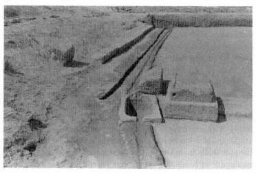
Fig. 63.
Western end of starting line in the Stadium, with stone base,
water channel, settling basin, and sidewalk, from the south.
Although the purpose of the two bases is uncertain, they may have supported statues.[118] Two black marble bases from around 300 B.C. , found near the starting line, may have supported statues of victors in the Nemean Games (see p. 37).
Even more uncertain is the purpose of a block 0.91 by 0.42 m. immediately north of the settling basin at the western end of the starting line. The placement of this block, however, involved a westward adjustment in the course of the water channel, as indicated by the double cutting for the exit of the northern channel of the settling basin.
The starting line itself is 21. 15 m. long, measured between the eastern and western bases. It consists of stone slabs with two parallel grooves for the athletes' feet cut into their upper
[118] Cf. the similar bases in the later stadium at Isthmia: Broneer, op. cit . (n. 96) 56-57, plan 6. Also compare the cuttings on the upper surface of a base for two statues south of the Altar of Zeus (see p. 154) for analogous recessed "panels."
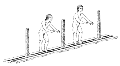
Fig. 64.
The ancient starting stance at the line.
surface. Although the southern face of each groove is nearly vertical, the northern face is cut at an oblique angle to the upper surface of the starting line. Such grooves are characteristic of starting lines in ancient stadia, including those at Olympia, Epidauros, and Delphi.[119] The grooves seem uncomfortably close to one another for the modern athlete accustomed to a four-point starting stance for foot races, but the ancient stance was erect, as seen in Figure 64 and documented in many ancient depictions.[120]
The northern groove is cut continuously across the length of the starting line. The southern groove, however, is interrupted at regular intervals by gaps of approximately 0.25 m.
[119] Olympia: Mallwitz, op. cit . (n. 62) 184-85; Epidauros: Kavvadias, op. cit . (n. 105) Pls. A': A, A"; B': 1, 3, 6, 10, 10', and Patrucco, op. cit . (n. 105) Figs. 21, XXVII. 1, XXVII.2, XXIX. 3, XXX. 1; Delphi: Aupert, op. cit . (n. 113) Figs. 124-26. Note the differences in the distances between the grooves at the various sites. Standardization seems to have existed, if at all, only at a given site.
[120] E. Norman Gardiner, Athletics of the Ancient World (Oxford 1930) 135. Upright stances were practiced until Thomas Burke introduced the four-point stance at the 1896 Olympics, where his victory in the 100 m. did much to bring this stance into popularity.
In each gap a square socket was cut, approximately 0.08 m. on a side and an average of 1.63 m. from the next socket, to hold a vertical post. Twelve such posts divided the original starting line into thirteen lanes. Later the starting. line was provided with an additional, more closely spaced, set of twelve cuttings. Presumably at the same time, the original cuttings were filled in. Almost all the later cuttings are approximately 1.30 m. apart. Unlike the original cuttings, these postholes are placed without regard to the southern groove of the starting line. Two of them, moreover, cut through the southern groove. Although these later cuttings measure approximately 0.10 m. on a side, the lead still preserved in three of them indicates that the projecting posts were 0.07 m. square.
Another major change in the starting line is indicated by the stone block that projects from the northern edge of the starting line near each of its ends. The projection near the eastern end has a wide central cutting on a north-south axis. On the bottom surface of this cutting a series of shallow cuttings run parallel to each other and at right angles to the starting line. In addition, the eastern side of the projection has another cutting that is perpendicular to and intercepts the wide central cutting. The projection near the western end of the starting line is similar to the eastern projection in the arrangement of its cuttings. It is constructed from a single reused block, however, and has an oblique cutting on its western, rather than its eastern, side.
Because the two projecting additions are cut into the blocks of the starting line between the first and second original square cuttings at each end, and because they respect the second set of posthole cuttings, they are evidently contemporary with the later modification in the size of the running lanes. The projecting blocks almost certainly supported the mechanism (hysplex ) used to start the races, although the precise nature of that mechanism is uncertain. Similar projecting blocks
exist in the stadium at Epidauros, the later stadium at Isthmia, and the racecourse in the Corinthian Forum.[121]
Out in the racetrack, 5.30 m. north of the starting line and 3.40 m. west of the center of the track, is a limestone block, 0.56 m. on a side, its upper surface level with the surface of the track. From a square hole in the upper surface a kampter , or vertical turning post, projected, probably of wood, marking the turning point at the south end of the Stadium. (Ancient races were run up and down the track, not around the track as today.) The base for a similar turning post presumably existed in a comparable position at the opposite end of the Stadium.
Further north along the western side of the track a row of stone blocks, immediately west of the water channel, marks the continuation of the sidewalk we first encountered upon entering the Stadium.
The row of stone blocks just west of the sidewalk, like the sidewalk itself, consists of reused material. The row extends, however, only to the Stadium entrance. Its blocks, 0.27 m. higher than the sidewalk, form the proedria previously mentioned. In some places, a third row of blocks is preserved, some of them actually cut from the bedrock in situ , which formed a second row of seats.
North of a settling basin, some 28.30 m. north of the starting line, two large limestone blocks are set against the eastern face of the water channel. The southern block preserves the remains of a 0.28 m. square cutting which held the 100-foot marker. These blocks, opposite the foundations for the judges' stand on the eastern side of the track, may have supported an auxiliary judges' stand.
[121] Epidauros: Kavvadias, op. cit . (n. 105) Pls. A': g , g ', d ; B': 6, 6'; Isthmia: Broneer, op. cit . (n. 96) 59, 140-42, Pls. 27d, 96; Corinth: C. H. Morgan, "Excavations at Corinth, 1936-1937," AJA 41 (1937) 550, Pls. XVI, XVII 1 foreground. Pausanias describes the hysplex in the hippodrome at Olympia (6.20. 10-14).
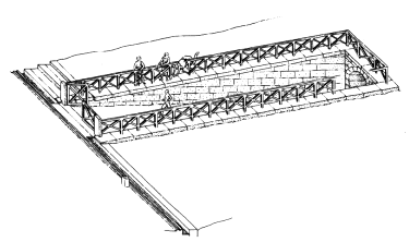
Fig. 65.
Reconstructed perspective drawing of the entrance passageway, from the northeast.
The Entrance Tunnel
Approximately 20 m. north of the so-called auxiliary judges' stand is a passageway leading to a vaulted tunnel, perpendicular to the line of the track, which was cut into the slope on the western side of the Stadium. Since this slope steepens toward the closed end of the Stadium, the placement of the tunnel only 50 m. From the starting line increased the difficulty of construction considerably. Had it been located 100 m. Further north, For example, no tunnel (and no construction) would have been necessary. The tunnel may have been situated to create a dramatic entrance For the athletes, who could enter the Stadium amid the crowds extending along both sides of the track (Fig. 65).[122]
The Stadium entranceway connected with the Sacred Way to the west (which has not been excavated), which in turn led to the Temple of Zeus approximately 400 m. northwest of the Stadium. Athletes and judges coming from the sanctuary entered the Stadium through this tunnel, which also served as a dressing and waiting area for athletes. The tunnel itself is constructed of a sandy, relatively soft limestone and is well preserved for its entire original length of 36.35 m., although it has been necessary to replace missing blocks at its mouth with concrete and to brace one area from which a voussoir has fallen.
The vaulted tunnel and entranceway were constructed in the last quarter of the 4th century B.C. The relation of the south wall of the entranceway to the blocks of the sidewalk and water channel indicates that all these structures are contemporary. As we have already indicated on the basis of other evidence, the sidewalk and water channel were constructed in the late 4th century B.C. Pottery fragments from the third and fourth quarters of the 4th century, moreover, were found in the foundation trench for the south wall of the entranceway. Contemporary, or possibly earlier, parallels for the vaulted construction used in the entrance tunnel exist in Macedonian tombs.[123] It seems likely that the arch was first introduced to Greece as a result of Alexander's conquests in the East.[124] Construction of the entrance tunnel, therefore, may well have resulted from Macedonian influence at Nemea, as seen, for instance, in Cassander's presidency of the games of 315 B.C. ,[125] which may have been responsible for the return of the games from Argos (see pp. 23, 40, 57-58). The Stadium and vaulted
[123] See M. Andronicos, Vergina: The Royal Tombs and the Ancient City (Athens 1984) 31-37, 55-232, and 238-39, with bibliography to other tombs; see also R. A. Tomlinson, "Vaulting Techniques of the Macedonian Tombs," APXAIA MAKED ONIA II (Thessaloniki 1977) 473-79.
[124] T. D. Boyd, "The Arch and the Vault in Greek Architecture," AJA 82 (1978) 88-89.
[125] Diodorus Siculus 19.64.I.
entranceway may thus be seen as part of the late 4th-century B.C. building program at Nemea, during which the Xenon, Bath, and Temple of Zeus were also constructed.
On each side of the mouth of the tunnel, a line of stone blocks extends almost 20 m. from the sidewalk to the eastern end of the tunnel. These blocks form the bottom courses of a retaining wall with flat coping blocks, which followed the slope of the hill to the top of the vault of the entrance tunnel (see Fig. 65). Ceramic evidence proves that the south wall of the entranceway collapsed before the 1st century after Christ, possibly as early as the late Hellenistic period,[126] crushing a nearby bronze statue or statues, almost two hundred fragments of which were found in the entranceway. These fragments include pieces of a hip, hair, and a wrist or ankle (museum case 7, p. 39). The subject of the statue or statues is uncertain. They may have depicted victors in the games, though at Olympia statues of Zeus (Zanes ) were set up at the entrance to the stadium, paid for with the fines imposed on athletes who had taken bribes.[127]
By the 1st century after Christ, the central area of the en-tranceway had been partly cleared of the fallen stones and the rectilinear terracotta water channel installed.[128]
The face of the tunnel opening itself is unornamented, nor is there evidence to suggest that an ornamental facade originally existed. On each side of the tunnel a letter was carved into the eastern face of the first block, on the sixth course down from the keystone. On the north wall is a chi , on the south, a delta . The significance of these letters is uncertain. A hole cut at the corner of these same two blocks was probably used to hold a rope or chain across the tunnel entrance.
[126] See Hesperia 48 (1979) 96. The blocks of the retaining wall which had fallen in have been lined up south of the entranceway.
[127] See Pausanias 5.21.5; 6.2.6; 6.18.6.
[128] The date of these developments is indicated by ceramic evidence, some of which is on display in museum case 10; see p. 44. See Hesperia 49 (1980) 198-99.
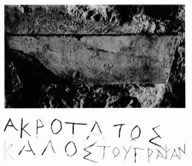
Fig. 66.
Stadium tunnel graffito 1 63 (Akrotatos kalos).
The surface treatment of the courses of blocks in the tunnel varies considerably. The preserved surfaces of all nine courses of the vault are smoothly finished and preserve traces of stucco. (They provided an excellent surface on which to scratch graffiti.) In contrast, the surface of the fifth course down from the keystone was finished on both sides of the tunnel with a chisel 0.06 m. wide. This created almost vertical bands, separated by sharp ridges of stone. On the bottom four courses on both sides of the tunnel, a chisel 0.13 m. wide created horizontal rows with a horizontal ridge between each row. It also left vertical chisel marks from each individual stroke. The surfaces of the two side walls were treated after their construction, apparently for decoration, although
the designs served as well to discourage graffiti at the level of these masonry courses.
Dozens of graffiti were scratched by athletes, often lightly, in the surface of the bottom two courses of the vault. In many of them a personal name is accompanied by the adjective kalos , "beautiful" or "fair." Several graffiti, moreover, can perhaps be identified with known individuals, including the name Telestas incised on the first block on the right (north) at the entrance to the tunnel (see p. 36).
Another noteworthy graffito is on the south wall about 9.50 m. from the eastern end of the tunnel. It is inscribed in crisp letters with the name Akrotatos. The same name (see p. 37) appears on the north wall 6.50 m. from the eastern end of the tunnel, on the third course down from the keystone. It is inscribed in bold letters 0.060-0.085 m. high (Fig. 66): "Akrotatos is beautiful". This rare name should probably be identified with the Spartan king Akrotatos, as already suggested.[129]
On the south wall of the tunnel approximately 8.00 m. from the eastern end, on the fourth course down from the keystone, are three superimposed graffiti, each in a distinct hand (Fig. 67). Toward the right side of the block is the earliest graffito, inscribed in letters 0.09 m. high. It has yet to be fully deciphered. Partly superimposed on these letters, and therefore later than them, is a graffito in which the lettering is neater and the strokes broader. Its letter height varies from 0.06 to 0.10 m., and it is legible as Epikrates kalos , "Epikrates is beautiful". At the upper left corner of the same block, a third graffito is inscribed in letters 0.025-0.035 m. high. Its late date is indicated by the relatively small amount of incrustation, its letter forms (e.g., the D is incised like a W),
[129] This graffito may also be identified with the identically named grandfather of Akrotatos, who had died by 305 B.C. See Diodorus Siculus 19.70; Plutarch, Agis 3.4; Pausanias 1.13.5; 3.2-3.
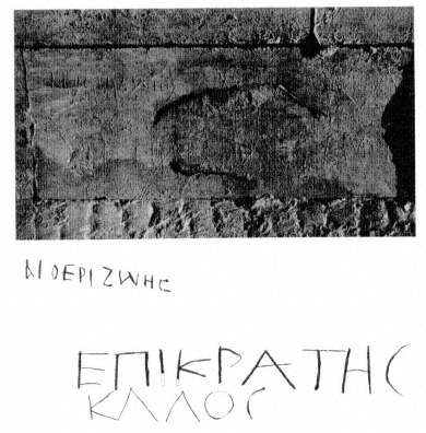
Fig. 67.
Stadium tunnel graffito 1 52 (Epikrates, etc.).
and the Christian connotations of the name in question: Aitherizoes, "Ethereal life" (see p. 47).
This graffito was probably inscribed during the latest period of activity in the tunnel. The construction of the terra-cotta water channel in or before the 1st century after Christ was followed by a long period of abandonment, during which the ends of the tunnel silted up. The silt sloped downward toward the middle of the tunnel: the side walls are lighter in color where they were covered and protected by the silt. By
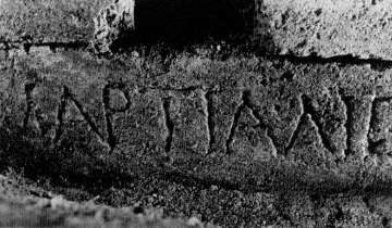
Fig. 68.
Stadium tunnel graffito I 68 (Martialis).
removing the easternmost keystone and the voussoir blocks flanking it, one or more persons subsequently entered the tunnel and used it for shelter. The numerous animal bones and fragments of cooking pottery found in the uppermost silt in the tunnel provide evidence of this activity, which is dated by numismatic evidence to the 570s or 580s after Christ (see museum, p. 47, and Basilica, pp. 94-95).[130]
The tunnel has at present been cleared for a distance of 19 m. from its eastern end, at which point scaffolding has been erected to support the vault. To reach the western end of the tunnel, it is necessary to return to the Stadium track and, just north of the Stadium entranceway, to proceed westward some 55 m. across the top of the hill through which the vaulted tunnel was cut. The western end of the tunnel, set deep in the earth of the hillside, has an unornamented face, like the eastern end. It also lacks the sloping walls that extend from the eastern end of the tunnel to the edge of the Stadium track.
[130] See Hesperia 48 (1979) 99, and Hesperia 49 (1980) 200.
Approximately I m. inside the western end of the tunnel is another of the latest graffiti on the north wall, on the fourth course down from the keystone. The name Martialis is deeply carved with letters of Roman form o. 12 m. high (Fig. 68). This graffito probably dates from the 1st or 2nd century after Christ.