Sacred Places
As noted in chapter 1, these were among the last North American Indians to have their aboriginal civilization altered by contact with outsiders, and it was probably due to this that spoken narratives and other information collected shortly after the turn of the century reveals such a close correspondence between mythology and practical knowledge. The degree of congruence is most strikingly demonstrated in Waterman's "Yurok Geography" (1920), which contains thirty-four annotated maps of Yurok territory and is certainly one of the most detailed studies of its kind ever made.
Waterman begins by telling us that aboriginal Yuroks conceived the world as a flat body of land, roughly circular, and surrounded by ocean, with the Klamath River running down the center.[1] Thus, it was believed that if a person left the mouth of the river and went far enough upstream, he would reach the water again. The land, with all its forests and mountains, was thought to float upon the ocean, constantly rising and falling as it heaved and settled in a rhythm too vast to be perceived by human beings (see diagram 1, p. 44).
Roughly in the center of the world lies the village of Kenek. Here, a being called "World-Maker"[2] made the sky, which was woven like a fish net. Upon finishing this, he heaved it aloft where it became solid, stretching over the world as the great blue sky. Above this ceiling, there was another region called "sky country," which could be reached by climbing an invisible ladder located just downstream from Kenek. In this conception the solid sky formed a sort of canopy that came down to meet the ocean on all sides. If one paddled far enough out to sea, it was theoretically possible by timing the rise and fall of the waves to slip through underneath, and thus one could leave the world. It was thought that Geese left the world regularly through their own special "sky hole."
Far across the ocean, well beyond the edge where the sky came down to touch it, was the home of Nepewo (the headman of the salmon) and of Dentalium Shell Money, both of whom lived there in wooden houses much like those the Indians occupied. Wohpekemeu also made his home there, and it was believed that these and other godlike beings visited the human world on a regular basis despite the terrific distances involved.
Within that part of the physical environment which was actually inhabited by humans were many places where mythic beings had left evidence of their presence. There was, for instance, a certain cliff by the seashore where Wohpekemeu had lain on his back, singing and slapping himself on the chest. When the tide was out, one could still see the marks that Wohpekemeu's feet had made as he kicked them about against the vertical face of the cliff (Waterman 1920:231). Not far from there, the Indians also showed Waterman an offshore rock that was known by a Yurok word meaning "refuse," as this was the place where Chickenhawk had thrown the guts of an enemy he had killed (1920:233). The number of similar examples in Waterman (1920) suggests that any natural configuration might come to have mythic relevance in Yurok thought.
These connections with the prehuman world were especially close at the village of Kenek, near the mouth of Tuley Creek on the Klamath River. Besides being the place where "World-Maker" made the sky, this was where Wohpekemeu first emerged from the earth, and the Indians who lived there during Waterman's visits (circa 1902-1909) could actually point to the pits where there had been houses occupied by deities such as Thunder, Porpoise, and Earthquake only a few generations before. Waterman also mentions that Kenek was regarded with special reverence by Indians of other villages.
Ordinary people do not dare step around in Kenek. Visitors used to come as far as the place where the trail crosses Tuley Creek and call. Then the people who belonged there would come down and get them, and show them around, so that they might not inadvertently step on some supernatural being's "place" and get into trouble. (Waterman 1920:252)
Not just at Kenek, but all over the region, walking trails were regarded as conscious beings, and in traveling the Indian had to observe certain rules in order to avoid insulting them. It was considered wrong, for example, to step out of a trail and in again without making some gesture of respect, and indeed the traveler had to observe many such customs. There were certain places where it was expected that a person would stop and rest while using a trail, whether he was tired or not, and there the Indian was often supposed to speak a prayer. The following example was recited by Sam Brown (Hupa) in 1927 and translated by Edward Sapir.
Key to Map 1
|
Map 1.
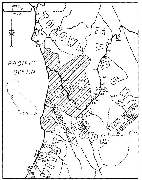
(left) Northwestern California, showing distribution of Yurok place
names outside Yurok territory. Inset map: California, showing the l
ocation of Yurok territory (shaded). (From Waterman 1920)
Map 2.
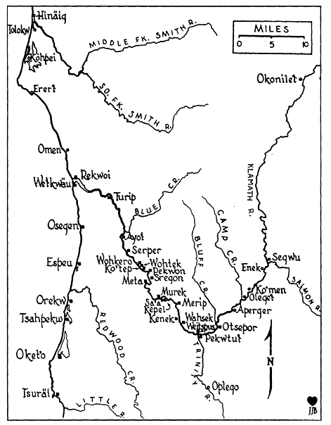
(above) Principal Yurok towns, indicated by black squares, along
the Klamath River and the northern California coast. Towns of the
Tolowa, Hupa, and Karok are indicated by circles. The names shown
for these are the Yurok ones. (From Spott and Kroeber 1942)
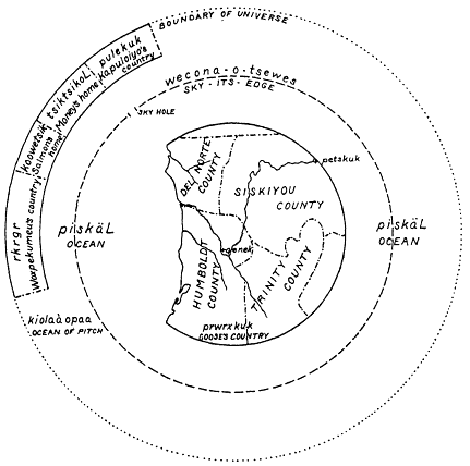
Diagram 1.
Waterman's map depicting the Yurok conception of the world (1920:192).
[You] lie here still. Let me go about without criticism. Let me grow old doing things this way. Let me keep coming back along this trail only with something good. Let me live happily. You have plenty of power, they say, oh [resting place]. May you look on me. May I live happily. May I grow old in the way I'm telling you. May you preserve my body. (Golla, in press)
There were other places where the traveler was expected to make a certain offering. In some instances, this meant dropping a
twig or branch where trails crossed one another, while in others the Indian was supposed to shoot an arrow into certain sacred trees so as to assure good luck.
The twig dropping is best described by Powers, who writes,
They have a curious custom of dropping twigs and boughs at the junction of trails, which sometimes accumulate in heaps several feet high, like the nests of woodrats. Every Indian who passes deposits a twig on the pile, but without observing any method that a white man can discover. No one will explain the custom, though it is probably observed, like so many other things, merely "for luck." (Powers, 1877 [1976]:58)
The custom of offering arrows to a sacred tree is described by Waterman, who explains that the arrow was a valuable piece of property in precontact times, since much time and effort were required to produce one. He also notes that the custom became distorted after the introduction of firearms, as the trees were then sometimes shot with bullets, leaving them scarred and stripped of bark (Waterman 1920:230-231).
The annotated maps in Waterman (1920) identify a number of special locations that were known as places where a Yurok person could pray or ask for help, and the following examples give an indication of their character:
1. A certain place on Bald Hills where there is an echo. One goes there to shout for help and the response tells whether or not the spirit will help (1920:197).
2. A rock offshore from Wilson Creek (False Klamath Rock). One of the wo'gey came to live in this rock, and he invites people to cry and ask for money while looking at the place (1920:230).
3. A place on the coast near the village of Omen. People would look around in the saltwater here for rocks to make arrowheads. After shaping them, they would "cook" the points by speaking a formula over them, after which they would be strong enough to shoot right through an elk (1920:233).
4. A submerged rock in the Klamath River (Posir Rock), just upstream from Ah Pah Creek. This rock was a "charm" for snaring deer. The hunter would dive underwater to touch it, and then
he rubbed his hands upon the snares, which guaranteed a catch (1920:238).
5. A large rock in the Klamath River below Pekwan. Pelintsiek ("Great Dentalium") used to live in the water here. In passing the rock by canoe, one stops alongside it in midstream, there clapping the hands and speaking a short prayer for luck (1920: 243).
6. A certain rock formation near the village of Merip. Arrowheads were placed in a cleft in the rock, and there they became "rusted" or covered with a poison that made them certain to kill (1920:250).
7. A point of rocks on Trinidad Head. The Yurok name for this rock formation is translated "He Sits Forever." A man went there to cry for luck and ask for money. Then he saw dentalium shells in the water, numerous as sardines. He sat there looking and refusing to leave until he gradually turned to stone (1920:270).
8. A cave at Trinidad Head. Its Yurok name has been translated "Where it Drops (or Trickles)." People went inside this damp cave to pray for money. If one drop fell on a person, then he would soon become wealthy. But if two fell upon him, then the rock would close up and he would never escape (1920:270).
Waterman felt that the Yurok had an unusually large number of named places within their territory, by comparison with other North American Indians, and he said that his monograph contained only about one half the places that might have been indicated if there were adequate time or space to include them clearly on the maps (1920:195). This very intensive view of the surrounding landscape was something which also impressed Powers, who commented on the care with which this information was transmitted from one generation to the next.
The boundaries of all tribes . . . are marked with the greatest precision, being defined by certain creeks, canyons, boulders, conspicuous trees, springs, etc., each of which has its own individual name. Accordingly, the squaws teach these things to their children in a kind of sing-song. . . . Over and over, time and again, they rehearse all these boulders, etc., describing each minutely and by name, with its surroundings. Then,
when the children are old enough, they take them around . . . and so faithful has been their instruction, that [the children] generally recognize the objects from the descriptions given them previously by their mothers. (Powers 1877 [1976]:109-110)
These teachings relating to geography were expressed in mythic terms, and mythic tales were also loaded with useful knowledge about the landscape. We learn, for example, from one Yurok narrative that Wohpekemeu used to fish at a place near the village of Kenek, just below the mouth of Tuley Creek (Kroeber 1976:110), but any fisherman could see why this is a good spot. Just above there is a very strong rapid, and this is the first real barrier that salmon and other species encounter on moving upstream from the mouth of the river. In this fashion, mythic belief and practical or scientific knowledge were woven into a single fabric.