27—
Yeh-lü Ch'u-ts'ai (1189–1243)
Yeh-lü Ch'u-ts'ai, an ethnic Khitan descended from a son of the founder of the Liao dynasty, served the Chin and the Yüan dynasties as an important official. His father had been Right Aide in the Department of State Affairs under the Chin, and Yeh-lü Ch'u-ts'ai soon rose to vice-director in the Left and Right Offices of the same department. In 1215, the Mongols conquered Yen-ching (modern Peking), the Central Capital of the Chin, after a ten-month siege, the Chin emperor having previously fled southward to the Southern Capital at Pien-ching (modern K'ai-feng). Yeh-lü remained in Yen-ching, but the shock of the ensuing destruction and pillaging by the Mongols led him to retreat from the world to study Buddhism with the Ch'an master Wan-sung Hsing-hsiu (1166–1246). Three years later, in 1218, Chinggis Khan (r. 1206–1227) summoned Yeh-lü Ch'u-ts'ai to an audience at his camp in Mongolia; Yeh-lü quickly gained his confidence both as an able official who could aid the Mongols in administering their growing conquests and as a skilled astrologer.
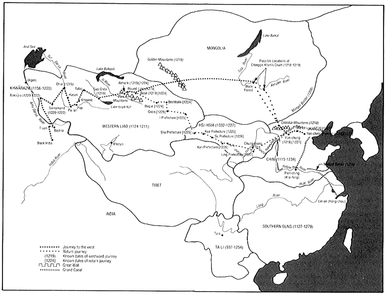
From 1219 to 1224, Yeh-lü Ch'u-ts'ai accompanied Chinggis Khan on his Western Campaign, the goal of which was the defeat of Shan Mohammed II of Khwarazm (d. 1220). With fewer than one hundred thousand men, Chinggis destroyed the numerically superior Moslems, and Yeh-lü witnessed the capture of the wealthy cities of Bokhara and Samarkand in 1220. It was in Samarkand the following year that he became acquainted with another eminent traveler from China, the Taoist master Ch'iu Ch'u-chi (Ch'ang-ch'un, 1148–1227), head of the Ch'üan-chen sect. On Yeh-lü's recommendation, Ch'iu had been summoned by Chinggis Khan, who wished to hear him expound his religious views. Ch'iu so impressed Chinggis that the khan conferred
5.
Yeh-lü Ch'u-ts'ai's Journey through the Western Region, 1218–1227
numerous privileges on him and his disciples, which emboldened the Taoists to seek control over their Buddhist rivals. Despite a surface cordiality between the two men, Yeh-lü, who believed in the underlying unity of Confucianism, Taoism, and Buddhism, soon regretted his sponsorship of Ch'iu.
When Chinggis Khan returned to Mongolia in 1224, Yeh-lü remained for a while in the Western Region. He then rejoined Chinggis for his campaign against the Hsi-Hsia Kingdom before making his way back to Yen-ching in 1227. Although slighted by Mongol historians, he was highly regarded by the Chinese, who credited him with helping to arrange the succession of Ogödei (Emperor T'ai-tsung of the Yüan, r. 1229–1241) under whom he rose to secretariat director. A man of wide scholarly and literary interests, Yeh-lü Ch'u-ts'ai strove to civilize the victorious Mongols by persuading them to establish many administrative and economic institutions based on Chinese patterns. He also sought, when possible, to alleviate some of the cruelties of Mongol rule.
Yeh-lü Ch'u-ts'ai wrote Record of a Journey to the West in 1228 and privately printed it the following year. It consists of two distinct sections with a preface. The preface presents an argument against sectarian conflict and heterodoxy. The first section, which is translated here, is a report of the cities he visited; it is, in fact, one of the few extant descriptions of the Western Region in the centuries following Hsüan-tsang's account. The second, longer section, in the form of a dialogue, is an attack on the reputation of Ch'iu Ch'u-chi, in which Yeh-lü, as an eyewitness, offers ten specific criticisms of Ch'iu's character and dismisses claims about Ch'iu's spiritual and intellectual powers. This appears to have been the real motivation behind Yeh-lü's text, for as the abuses of the Ch'üan-chen sect grew, Yeh-lü felt obliged publicly to disassociate himself from the Taoists, something that became possible for him only after the deaths of both Chinggis Khan and Ch'iu Ch'u-chi in 1227. Around the same time, a detailed, hagiographical account of Ch'iu's journey, titled The Perfected Master Ch'ang-ch'un's Journey to the West (Ch'ang-ch'un chen-jen hsi-yu chi , ca. 1228–1230), appeared. It was written by his disciple Li Chih-ch'ang (1193–1278), an important Taoist prelate, and was designed to promote the interests of the Ch'üan-chen sect by recording the patronage of Chinggis Khan and the miracles performed by Ch'iu. (It was translated into English in 1931 by Arthur Waley as The Travels of an Alchemist .) Yeh-lü Ch'u-ts'ai may well have been aware of an early version of this work and decided to respond to its extravagant claims.
Yeh-lü's text was not widely disseminated after his lifetime,
perhaps because one of his sons was devoted to Taoism. The two parts were separated by later editors and reassembled only in 1926, when a complete version was discovered in Japan. Although Yeh-lü Ch'u-ts'ai describes his journey in terms of a string of cities, in many places the account does not reflect his actual itinerary. He mostly accompanied Chinggis Khan's camp and in between traveled back and forth between places on missions for the khan. One must thus rely on other sources, such as his poems and official histories, to suggest his probable route.
From Record of a Journey to the West  (1228)
In the spring of the year wu-yin , the day after the moon reached its height in the third month [April 12, 1218], I, the Lay Scholar of Profound Clarity,[1] was commanded to be in attendance on a journey to the West. After the Imperial Army returned victoriously, in the winter of the year ting-hai [1227–1228], I was ordered to collect books and records, and my route brought me to Yen.[2] There, I was resting when a guest felicitously arrived and directly asked me, "Your journey to the West must have taken you over thousands of miles. Could I hear something of the events of this journey?"
I replied, "I set out from the Tomb of Eternal Peace, went through the Chü-yung Pass, passed through Wu-ch'uan, went forth east of Yün-chung, arrived north of the Celestial Mountains, traversed great sandhills, and crossed over the Desert.[3] In less than a hundred days, I reached the Traveling Court.[4] Mountains and rivers crisscrossed; how lush was the verdant land! The covered wagons were like clouds; the army, like rain drops. Horses and oxen covered the plains; foot soldiers and troops in armor emblazoned the sky. Fires and smoke viewed each other from afar; fortified camps stretched for thousands of miles. Never has there been such magnificence throughout all history!
"In the following year [1219], the Imperial Army commenced its Western Campaig,[5] the route passing through the Golden Mountains.[6] It was just at the height of summer, yet snow flew about on the mountain peaks and the accumulated ice was more than a thousand feet high. His Majesty commanded that the ice be cut through to create a road for the army. The springs in the Golden Mountains number somewhere in the many hundreds; pines and junipers reach the sky, while flowers and grass fill the valleys. I viewed it from the summit: all the peaks competed in beauty, streams struggled with each other to flow through the rugged ravines—truly a most magnificent view! West of the Golden
Mountains, the rivers all flow westward into the Western Ocean. Thus has Heaven defined the boundary between East and West!
"In the southern corner of the Golden Mountains is a city of the Uighurs called 'Beshbalik.'[7] It has a T'ang stele known as the 'Desert-Ocean Army Stele.'[8] The 'Desert-Ocean' is more than a hundred miles northwest of the city. There are 'islands' in this 'ocean' that are covered by the feathers left by birds. More than seventy miles west of the city is Bugur;[9] there is a T'ang stele there. One hundred seventy-five miles south of the city is Qoco, known as 'Kao-ch'ang' during the T'ang, also called 'I Prefecture.'[10] Around twelve hundred miles west of Kaoch'ang is the city of Khotan, known as the kingdom of Yü-t'ien during the T'ang.[11] The Black and White Jade rivers emanate from here.[12]
"After traveling about three hundred fifty miles beyond the Desert-Ocean Army Region, there is the city of Bolat,[13] which controls several other towns nearby. South of Bolat are the Dark Mountains,[14] which stretch for some three hundred fifty miles east to west and seventy miles north to south. On the summit is Round Lake,[15] around twentyfive miles in circumference. After passing Round Lake, descending to the south are groves of apple trees whose lush shade keeps out the sun. After coming out of the Dark Mountains, there is the city of Almalik.[16] When men of the Western Region saw these apple groves they called it 'Almalik,' for the entire surrounding area contains apple farms, and it is from these that it derived its name. It controls eight or nine cities where many grapes and pears can be found. They also raise the five kinds of grain,[17] just like in the Central Plains of China.
"Farther west is a great river named the 'I-lieh.'[18] West of this river is a city named 'Gus Ordo,' which was the site of the capital of the Western Liao dynasty.[19] It controls several tens of cities.
"Farther west more than a hundred miles is the city of Talas.[20] Farther southwest more than a hundred forty miles are the cities of Khojend, Pap, Kasan, and Pa-lan.[21] Khojend has many pomegranate trees; the fruits are as large as two hands clasped together, and are sweet with a tinge of sourness. Three to five pieces yield about one large cup of juice, excellent for quenching thirst. Beside the city of Pa-lan are pa-lan groves, hence the name. The flowers of the pa-lan are like those of the common apricot tree, but somewhat lighter in shade; the leaves are like those of the peach tree, but smaller. Every winter they blossom; by the height of summer, the fruit ripens. It is shaped like the flat peach, but the flesh is not fit to eat, only the pits are consumed. The large watermelons of Pa-p'u weigh as much as sixty-five pounds; a mule can carry only two at a time. Their flavor is sweet, cool, and delicious.
"About one hundred seventy-five miles farther northwest of
Khojend is the city of Otrar,[22] which controls more than ten neighboring cities. The leader of this city murdered our dynasty's ambassador and a number of his entourage as well as more than a hundred merchants, plundering their goods. This was the initial reason for this Western Campaign.
"More than three hundred fifty miles west of Otrar is a great city named 'Samarkand.'[23] 'Samarkand' means 'fertile' among the men of the Western Region, and this place was so named because of its fertile soil. The Western Liao named this city 'the Superior Prefecture of Hochung' because of its proximity to the river.[24] Samarkand is extremely rich. They use gold and copper coins without holes or raised edges; all merchandise is weighed out by scales. There are gardens everywhere in the surrounding outskirts, stretching for several tens of miles. Every house must have a garden, and these gardens are always fascinating in design. They all employ canals and fountains, square ponds, and round pools; cypresses grow next to willows, and peach trees intertwine with plum, creating one of the most impressive scenes today. Large melons are the size of a horse's head and long enough to contain a fox. Of the eight kinds of grain, they lack millet, glutinous rice, and soybeans, but they have all the others.[25] At the height of summer there is no rain, so they transport water by means of canals. Every third acre of land is irrigated with over two hundred gallons of water. They ferment grapes, the flavor resembling the 'Nine Fermentations Wine' of Chung-shan.[26] Though there are plenty of mulberry trees, few people know how to raise silkworms, so silk is extremely rare and they all wear cotton. The local people consider white an auspicious color, while black clothing is worn at funerals, so everyone wears white.
"Between two hundred and two hundred fifty miles west of Samarkand is the city of Bokhara.[27] The produce here is even more plentiful, and the cities and towns quite numerous. Samarkand was the capital of the Shan of the Moslems.[28] Bokhara, Khojend, and Otrar were subject to it.
"West of Bokhara is a great river named the Amu Darya, slightly inferior to the Yellow River, which flows west into the Great Sea.[29] West of this river is the city of Urgenj, where the mother of the Shan lived.[30] Its wealth surpasses that of Bokhara.
"Farther west along this great river is Bactria, which is quite prosperous.[31] Farther west is the city of T'uan, which is also magnificent.[32] In the city can be found many items made of lacquer that bear the mark of Ch'ang-an.
"I proceeded directly west of here, arriving at the city of Black India.[33] The people of this kingdom also have a written language, but it
differs in alphabet and sound from that used in the Buddhist kingdoms. There are many Buddhist statues throughout this kingdom. The people do not butcher cows or goats but do drink their milk. According to their custom, when the husbands die first, their wives are cremated together with them. I inquired about the location of the Buddhist kingdoms, and they indicated that they lay to the southeast. After investigation, I concluded that this kingdom is not northern India proper; the inhabitants are a border people on the north of India. The local inhabitants have never seen snow. There are two harvests of wheat every year. At the height of summer, they set out pewter utensils in the sand and are immediately able to solder them. When the dung of horses falls to the ground, it begins to boil. The moonlight shines down on people like the summer sun in the Central Plains of China. In the evening, they often escape the heat in the shadows of the moonlight. South of this kingdom is a great river as broad as the Yellow River, as cold as ice and snow, whose swirling current is swift and dangerous. It comes from slightly west of here and flows directly south and slightly east. I would reason that it must enter into the Southern Ocean. Furthermore, the land produces much sugarcane on fields as wide as those which grow millet. The local people squeeze out its juice, fermenting it into wine and boiling it to make sugar.
"Northwest of Black India is the kingdom of Kipchak.[34] For a thousand miles there are calm rivers everywhere without any hills. Ah, it is a strange place indeed! There are no cities, and the people mostly raise goats and horses. They make wine from honey, but the flavor is not too different from the wine of the Central Plains of China. In this kingdom, the days are long while the nights pass quickly. Before the shoulder of a lamb is fully cooked, the sun rises again. It tallies exactly with what the History of the T'ang Dynasty records about the kingdom of Quriqan;[35] however, the names of these kingdoms are different. Could it be that after so long a time, the sounds of these names have become confused? Samarkand is almost seven thousand miles from the Central Plains of China, India is the same distance from Samarkand, and Kipchak is the same distance from India.[36] Even though the road is circuitous and winding, I would not consider these places nearby, for they are I don't know how many tens of thousands of li away.
"When the year fell on chün-t'an [1224], the Imperial Army set forth on a campaign. The Hsi-Hsia had betrayed our trust and violated treaties,[37] so, in the second month of spring of the year ping-hsü [March 1226], the entire Six Armies attacked in successive waves and in one blow conquered it. Their leader was executed, but the common people were allowed to dwell in peace.
"Sha Prefecture and Kua Prefecture were established by the Han dynasty.[38] Su Prefecture is equivalent to Shan-shan.[39] Kan Prefecture is equivalent to Chang-yeh.[40] Ling Prefecture is equivalent to Ling-wu.[41] Ah! Traveling toward the horizon to the corner of the sea where no man ventures was indeed an extraordinary series of events. This, in general, was what I saw on my journey to the West."[42]