
Regularization, Reduction, and Isolation
Comprehensive urban design projects that targeted the reorganization of the entire settlement were few and far between. Engineer Poirel's 1837 proposal to regularize and widen the street network, bringing the secondary streets to 3 and 5 meters wide, received a great deal of criticism due to its excessive catering to private interests.[43] Later designs focused on the extension of the city and only marginally ad-
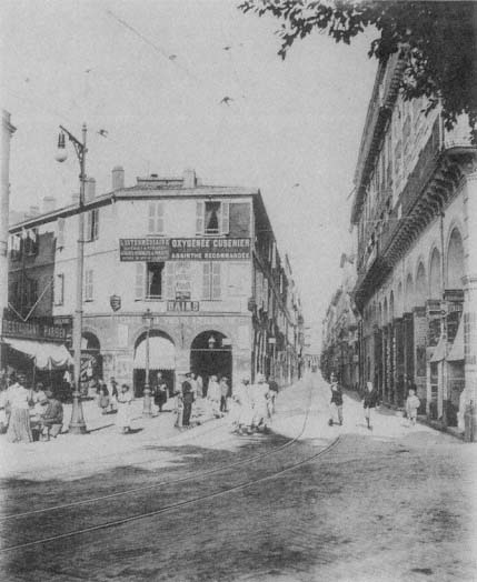
Figure 16.
Rue Bab Azzoun, c. 1990.
dressed the old town. One example is Charles Delaroche's 1848 project, which doubled the size of Algiers by new fortifications and a modern settlement with wide arteries and squares in the European quarter (Fig. 18). Delaroche's unrealized interventions to the casbah consisted of broadening three major streets that cut across the old town and carving a few squares at important intersections.

Figure 17.
Plan of the casbah. (1) Boulevard Gambetta, (2) Boulevard
de la Victoire, (3) Boulevard Vallée, (4) Rues Randon and Marengo,
(5) Rue Bab el-Oued, (6) Rue d'Orléans, (7) Rue de la Marine, (8)
Place du Gouvernement, (9) Place de Chartres, (10) Rue Bab
Azzoun, (11) Rue de Chartres, (12) Rue de la Lyre.
The realization of a main artery on the waterfront, Rue Militaire, first presented in a sketch by Poirel in 1837 and intended to serve the harbor as well as act as a promenade, was delayed until 1860. When construction began, the artery was named Boulevard de l'Impératrice, celebrating the visit of Empress Eugénie and Napoleon III to Algiers the same year. It was completed in 1866 according to Charles-Fréderick Chassériau's plans (Fig. 19). A particularly difficult feat of engineering due to the drastic difference in level between the boulevard and the embankment, the structure was supported by a series of high arches recalling a bridge or an aqueduct. The ramps connecting the Boulevard de l'Impératrice to the harbor level took another eight years to build.[44] The project gave Algiers its memorable waterfront: the continuous high arcade of the lower level, animated by the changing scale of the arches supporting the ramps and in juxtaposition to the more delicate arcades of the Boulevard de l'Impératrice on the upper level—all in white.
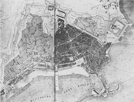
Figure 18.
(above) Plan by Charles Delaroche, 1848.
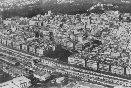
Figure 19.
(below) Aerial view of the arcades and the Boulevard de l'Impératrice, 1933.
While providing a spectacular edge to Algiers, this project also engraved the power relations of the colonial order onto the urban image: the casbah was locked behind the solid rows of French structures.
The obsessive focus on defense generated persistent demands for the enlargement of the fortified areas—a debate that had started in 1840.[45] By 1849, the old fortifications were replaced by new ones, enclosing an area three times larger than the one occupied by the old town. The lower part of the casbah had acquired a more regular street network with two main arteries, Rue de la Marine and Rue d'Orléans, which connected Rue de la Marine to Rue Bab el-Oued (see Fig. 17). The European settlers—French, but also Italian and Spanish—lived here, while the upper casbah became an exclusively indigenous town. The distinction between the two parts was reflected in their new names: the upper casbah became the "casbah" proper and the lower town became the Marine Quarter.[46]
The conjuncture of the casbah and the Marine Quarter was subjected repeatedly to regularization proposals. In 1917, for example, a project devised for the area defined by Chartres, Vialar, and Bab Azzoun streets and Place du Gouvernement, advocated the enlargement of Rue Bab Azzoun by appropriating 6-meter strips from its west side, thereby changing the width from 8 to 14 meters. In addition, Rue de Chartres and Rue de Vialar would be widened to 10 meters, and transversal streets, 8 meters wide, would connect the main arteries running parallel to the waterfront.[47]
Of various plans devised for the Marine Quarter, the one proposed by Eugène de Redon in 1884 has been revived several times, most significantly in revised versions between 1901 and 1914, and in 1922 (Fig. 20). Redon's project was initiated by the municipality's growing concern about public hygiene in the Marine Quarter, in the area between Rue Bab el-Oued and Boulevard de la République on the waterfront (the original Boulevard de l'Impératrice). The municipal authorities agreed to "raze whatever existed" here.[48] Although Redon's project addressed the entire city, its main impact was restricted to the proposals for the Marine Quarter, because it established clear strategies to resolve the chaotic structure of this area. The essence of the proposal involved the displacement of half of the population residing in the quarter, specifically the urban poor, who would be relodged in new housing projects to be built on the hills of the Bab el-Oued Quarter to the northwest of the old town. This depopulation would enable the replacement of narrow streets with large arteries lined with luxurious buildings to attract the wealthy bourgeoisie. A 25-meter-wide main avenue, Avenue de la
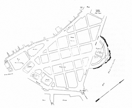
Figure 20.
Eugène de Redon's plan for the Marine Quarter, 1925.
Préfecture, would extend the Boulevard de la République. At the beginning point of the avenue, close to the Place du Gouvernement, placement of the stockmarket and the Tribunal of Commerce expressed the ambition to turn the Marine Quarter into an impressive business center. The reorganization of the area would result in the reorientation of the al-Jadid Mosque and demolition of the al-Kabir Mosque, with plans to rebuild it on the northern flanks of the casbah.[49]
The 1922 version of the Redon plan emphasized once more the quarter's congestion and the necessity for erasing the entire area to accommodate circulation and called for the displacement of twelve to fifteen thousand people. The new buildings would cater above all to the needs of commerce.[50] In this version, however, the two mosques were preserved and a prominent casino was placed where the main avenue met the waterfront in the north.
Interventions to the casbah proper were relatively few. The north-south Rue de la Lyre (present-day Rue Ahmed Bouzrina), parallel to the Rue Bab Azzoun, stood out with its straight layout and continuous colonnades amid the irregular street fabric surrounding it. Projected in
1845 but completed in 1855, it connected the center with the newly planned suburb Bab Azzoun and eased the heavy circulation on the axis of Rue Bab Azzoun and Rue Bab el-Oued.[51] Its architectural qualities made it especially significant to the French as a reminder of the Rue de Rivoli, a cherished urban fragment from Paris now implanted in Algiers. Rue Randon (now Ali la Pointe), its extension Rue Marengo (now Arbaji), and Rue Bruce were also cut through at this time.[52] Other major alterations carried out in the 1840s included two straight boulevards, Boulevard Vallée (present-day Boulevard Abderazak Hadad) on the north and Boulevard Gambetta (present-day Boulevard Ourida Meddad) on the south, both built on the glacis of the Ottoman fortifications.[53] Remaining at the edges of the old town, the major interventions during the early phases of the colonial rule may seem to have had little effect on the core of this introverted settlement. Nevertheless, the boulevards encircled the casbah and signified the surrender of the original residents of Algiers to the French—literally and metaphorically.
French architects early on acknowledged the immense difficulty of cutting through the casbah. A report submitted to the governor general of Algeria in 1858 pointed to the futility of fighting "against nature," against the capricious, "tormented," and "accidental" topography of the casbah. Arguing that the needs of the French were different from those of the indigenous people, the report proposed the construction of a new town, which would cater to European tastes, next to the old one.[54] Napoleon III's "arabizing" policies enhanced the conservation of the casbah further. The new policy of "tolerance" that dominated the 1860s criticized former demolitions and European constructions in the old town, which had pushed the local population to upper slopes and resulted in highly congested living conditions. The report that followed the emperor's research maintained that
the town must conserve its actual physiognomy, that is to say, the high town must stay as it is, because it is appropriate to the customs and habits of the indigenous; cutting through grand arteries may result in causing them great suffering, and all these improvements may impose hardships to the indigenous population, which does not have the same lifestyle as the Europeans. The emperor thinks that the lower town should be reserved for the latter and it is in that part that all works of improvement and beautification should be made.[55]
In the late 1870s Eugène Fromentin summarized the early colonial policies Napoleon III aimed to change and commented on the rationale and extent of the French appropriation of Algiers:
France took from the old town everything that was convenient for her, everything that touched the waterfront or dominated the gates, everything that was more or less level and that could be easily cleared, and readily accessible. She took the Djenina, that she razed, and the ancient palace of the pachas, that she converted into the house of her governors . . . . She created a little Rue de Rivoli with Bab Azzoun and Bab el-Oued streets, and peopled it with counterfeiting Parisians. She made a choice between mosques, leaving some to the Qu'ran, giving others to the Evangelists.[56]
After these initial interventions, the casbah was left on its own. If demolition was no longer the issue, neither was maintenance. Algerian urban sociologist Djaffar Lesbet argues that the implicit menace of destruction to the casbah posed by neglect played a constructive and catalyzing role on the residents and forced them to pool their resources to stop the "natural" demolition of their neighborhoods. The basis for an alternative urban administration was established, operating on two levels: the maintenance of public open spaces by designated officers from the casbah and the maintenance of individual houses by the collaborative and organized labor of renters and owners. The residents of the casbah thus spoke back to colonizers by turning to themselves, consolidating their unity, and establishing their own system. With this move, Lesbet maintains, the casbah was transformed into a "counter space" (espace contre ) that represented the oppositional voice of Algerians to colonial power.[57] The diametric stances of the casbah and the French Algiers, crystallized further by the former's "counter space" character, destroyed any possibility of overall harmony in a situation distinct to French colonial urbanism. In the words of Fanon, "The zone where the natives live is not complementary to the zone inhabited by the settlers. The two zones are opposed, but not in the service of a higher unity. Obedient to the rules of pure Aristotelian logic, they both follow the principle of reciprocal exclusivity. No conciliation is possible."[58]