I—
The Occupancy and Abandonment of the Island
Delightful I think it to be in the bosom of an isle, on the peak of a rock, that I might often see there the calm of the sea.
Anonymous Irish author, twelfth century
Christian monasticism had its conceptual roots in the belief that union with God could best be attained by withdrawal from civilization into harsh and isolated regions. In the third century, Egyptian Christians fled the distractions and temptations of cities to live solitary lives of prayer, meditation, and fasting in the desert. The fame of St. Anthony (ca. 251–356), the great founder of eremitic monachism, spread rapidly throughout Egypt; his duels with the devil while locked in a tomb and his decades of total isolation in the most inhospitable areas of the Egyptian desert became the heroic model for a multitude of followers.
Solitary withdrawal rapidly evolved into a form of eremitism that permitted groups of ascetics to live separately yet in proximity to one another, meeting only on Saturdays and Sundays for the celebration of a common religious service. Before Anthony died, however, another great Egyptian, St. Pachomius (292–346), introduced in southern Egypt a new concept of monastic withdrawal, one in which large groups of monks banded together to live and worship in common. Revised for the eastern Mediterranean by St. Basil of Anatolia (ca. 330–379), who became familiar with the Pachomian system while journeying in Egypt, and by St. Benedict of Nursia (ca. 480–547), who was familiar with St. Basil's concepts of monastic living, this form of collective withdrawal from the secular world became in the centuries to follow the dominant form of Christian monasticism in the lands bordering the Mediterranean and in Europe.
Yet St. Anthony's vision of solitary withdrawal into bleak areas where survival is difficult has remained over the centuries the ideal—the purest form of monastic life. From St. Simeon Stylites (ca. 390–459), who lived for decades on a pillar fifty feet high, to the nineteenth-century recluse who established himself on a volcanic plug in the Hoggar Mountains of the African Sahara, Antonian monasticism has continued to be practiced by a few highly motivated ascetics.
One of the most spectacular inaccessible regions of monastic withdrawal is in the province of Thessaly near the village of Kalabaka in Greece, where rock masses have eroded into isolated columns ranging in height from eighty-three to three hundred feet. Some have described these columns as gigantic tusks, others, as sugarloaves or gigantic stalagmites (Fig. 3). In the mid-
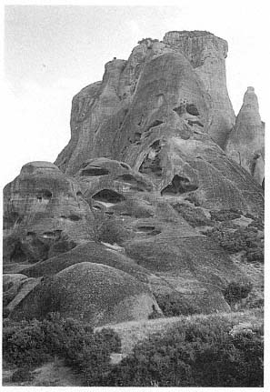
Fig. 3
Meteora, Northern Thessaly, Greece. One of the
dramatic geological formations near the village of
Kalabaka. From the fourteenth century onward,
hermits made their retreats in its cavities and
recesses.
Photograph by Walter Horn.
fourteenth century a hermit chose one of them as a place of refuge. He was soon followed by others, and eventually some of these hermitages developed into monasteries accessible only by ropes and a net worked by a windlass from above (Fig. 4). The group of monasteries is called Meteora, which means "suspended in the air."[1]
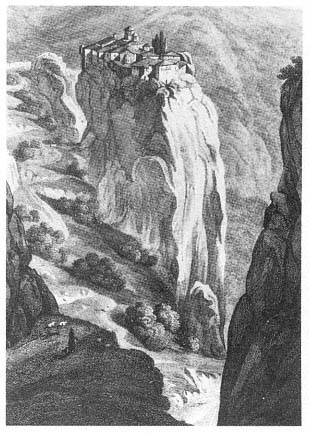
Fig. 4
Meteora, Northern Thessaly, Greece. The Monastery of
Barlaam in the Great Meteora Complex, founded early in
the sixteenth century by the brothers Nektarios and
Theophanes.
Drawing by C. R. Cockerell, from Donald M. Nicol,
Meteora: The Rock Monasteries of Thessaly .
We had thought of the hermitages and monasteries of Meteora as the climax, the ne plus ultra, of monastic withdrawal until we came to work on the Irish island of Skellig Michael. In the course of investigating the island, we were startled to discover the architectural remains of a hermitage five hundred years older than the earliest hermitage of Meteora. On Skellig Michael, an island at the western edge of the European land mass—at the time the monastery was founded, the western edge of the Christian world—was a hermitage even more awesome than Meteora (Fig. 5): seven hundred feet above the sea, clinging to the narrow ledges of an austere pinnacle, the Skellig Michael hermitage is a visual wonder and a marvelous feat of construction.
[1] For a general overview of Meteora see Nicol, 1963, where all previous literature is listed.
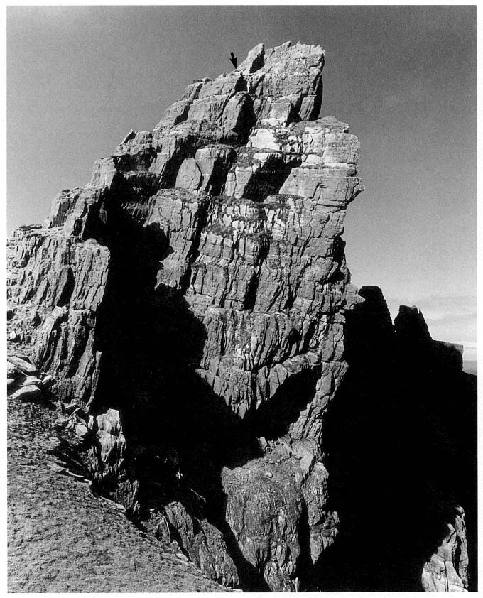
Fig. 5
Skellig Michael, South Peak. A photograph of the peak from the southeast, with an arrow marking the
location of the oratory terrace.
Courtesy Office of Public Works, Ireland.
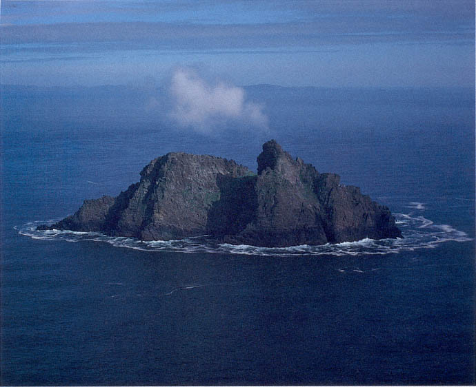
Fig. 6
Skellig Michael, aerial view from the north.
Photograph by Walter Horn.
The island of Skellig Michael lies 11.6 kilometers off Bolus Head, the westernmost tip of the Iveragh Peninsula, County Kerry, Ireland (Map 1). The mass of rock from which the island was formed in the Devonian period some four hundred million years ago consists of hard compressed sheets of sandstone mixed with silt and gravel. During the great Armorican upheaval that created the mountains of Kerry two hundred million years later, Skellig Michael, which is connected to these mountains, rose above the sea. This mountain building was accompanied by the mass movement and translocation of rocks called jointing and faulting by geologists. Subsequent faulting and erosion over millions of years created a U-shaped depression, today named Christ's Valley or Christ's Saddle, 130 meters above sea level in the middle of the island. On either side of this small valley a peak rises, one to the northeast 185 meters high and one to the west-southwest 218 meters high (Figs. 6–8).[2]
[2] Frank Mitchell, written communications, 1982, 1987. Whatever we know about the time and early geological cataclysms that led to the birth of the island and its ultimate shape, we owe to the expertise and kindness of Frank Mitchell and Michael O'Sullivan, both of whom visited us on Skellig Michael on different occasions.
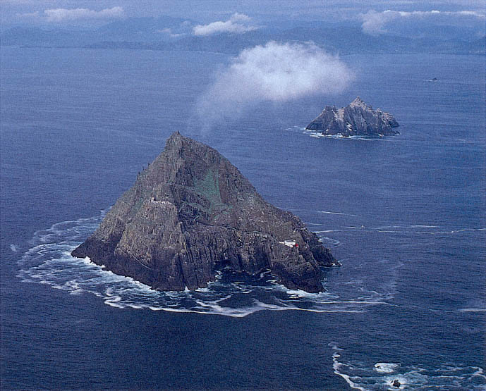
Fig. 7
The Skellig Islands, aerial view from the west. In the foreground, the larger of the two Skelligs, Skellig Michael; in the middle
ground, Little Skellig, never inhabited but used each year as a breeding ground by twenty to forty thousand gannets; in the
background, the mountains of the Ring of Kerry.
Photograph by Walter Horn.
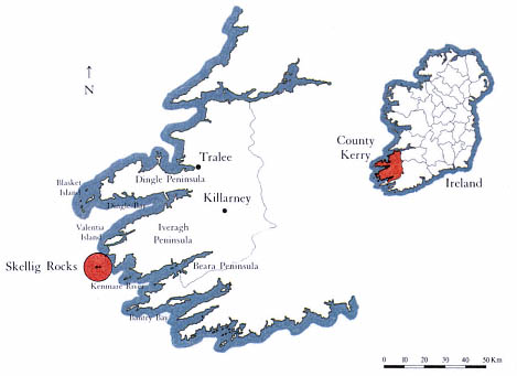
Map 1
Skellig Rocks. Location map
by Grellan Rourke, 1986.
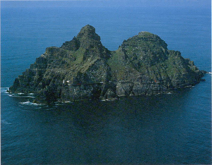
Fig. 8
Skellig Michael, aerial view from the south. The lower, broader summit at the northeastern end of the island became the location
of the monastery of Skellig Michael. On the high ledges of the steeper peak at the southwestern end are the parts of the
hermitage that is the subject of this study. The monks who came to the island called the depression between the peaks
Christ's Saddle, a name it still retains.
Photograph by Walter Horn.
Between the sixth and eighth centuries the island became a place of refuge from the world for a small settlement of ascetic monks. The broad summit on the northeastern side of the valley became the site of their monastery, comprising six beehive cells and two oratories. Probably no more than twelve monks and an abbot ever lived here at one time (Fig. 9 and Map 2).
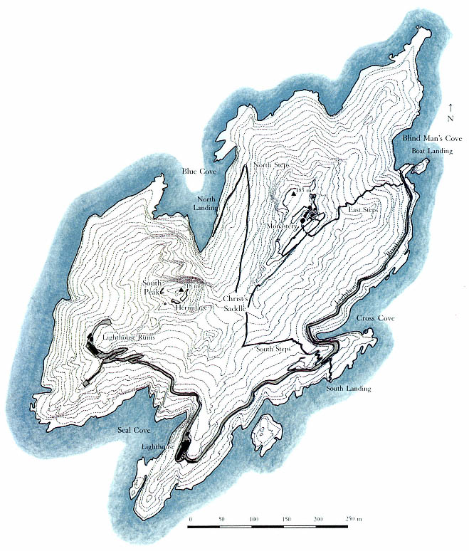
Map 2
Skellig Michael. Contour map by Grellan Rourke, based on a photogrammetric survey by Hempenstall Survey and Scientific
Instruments, November 1982. The road on the southern and eastern flanks of the island was built between 1820 and 1826
by the predecessor of the Commissioners of Irish Lights. It ascends, gradually at first, from Blind Man's Cove (where all
modern visitors land) to the ruins of the upper lighthouse.The monks who founded the monastery built the stairways
represented by the thinner lines on this map. The east steps, which lead to the monks' garden and then on to the oratories
and beehive huts, were made inaccessible from below when the landing pier was built at Blind Man's Cove; the south steps,
which start at a crude landing, ascend dramatically from Christ's Saddle toward the monastery; and the north steps, which
are rarely used by modern visitors, zigzag toward Christ's Saddle, where they merge with the south steps.
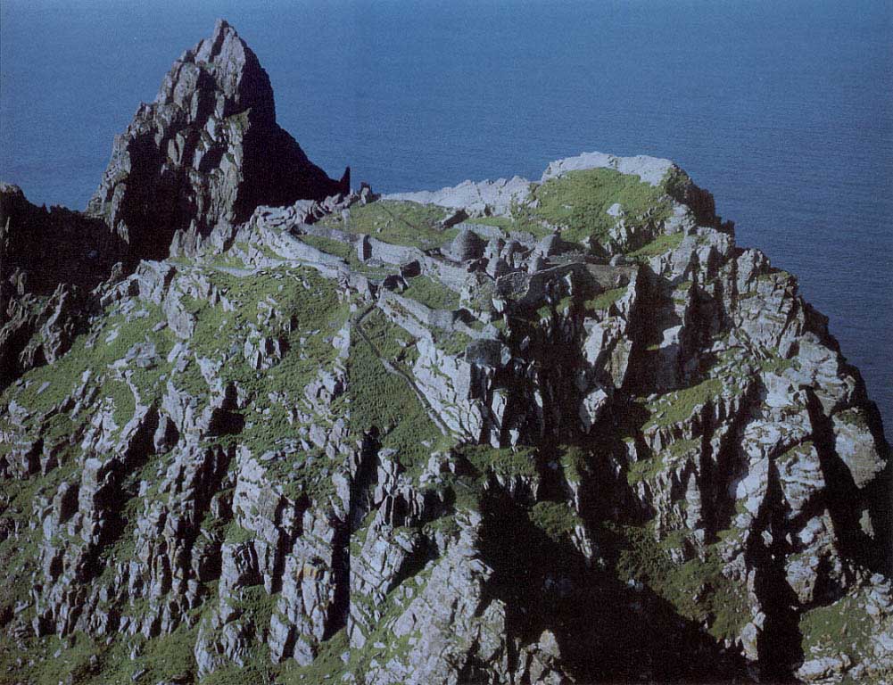
Fig. 9
Skellig Michael. Aerial view of the monastery from the southeast (South Peak in the background).
Photograph by Jim Bambury.
Courtesy Office of Public Works.
Legend ascribes the founding of the monastery to St. Fionan, who lived in the sixth century.[3] The earliest documentary reference to the monastery is an entry in The Martyrology of Tallaght , written near the end of the eighth century by Máel-ruain (d. 792) in his monastery near present-day Dublin. It commemorates the death of a monk of Skellig called Suibni (Suibni in Scelig ).[4] To be acknowledged in this manner in the festology of one of the most celebrated monasteries of Ireland, located at the opposite side of the country, Skellig Michael must have been a well-established and widely known monastic settlement. The monastery there may well have been founded as early as the sixth or seventh century, but in the absence of documentation more precise dating is not possible.
The monastery is referred to simply as Skellig in the eighth- and ninth-century entries in monastic festologies and annals (The Martyrology of Tallaght , the Annals of Ulster , and the Annals of Inisfallen ). Sometime after the tenth century the monastery became known as Skellig Michael. It is likely that in the late tenth or early eleventh century the monastery was dedicated to St. Michael.[5] This is suggested by two references to the monastery in the Annals of the Kingdom of Ireland by the Four Masters . The first reads "Age of Christ, 950. Blathmhac of Sgeillic died"; the second, which reads "The Age of Christ, 1044. Aedh of Sgelic-Mhichil," is the first reliable mention of the name Michael in the annals.[6] On this basis we assume that the dedication to Michael took place between 950 and 1044. It was customary in a monastery to build a new church to celebrate a dedication, and the oldest part of the church now known as St. Michael's fits architecturally into this time period. With its mortared straight walls and large stones, the church is unlike the dry-stone corbeled oratories and beehive cells built earlier at the monastery.[7]
The church of St. Michael was mentioned in The History and Topography of Ireland , by Giraldus Cambrensis, who was in Ireland with the Normans in the late twelfth century (1183 and 1185). His account of the miraculous supply of communal wine for daily mass in St. Michael's church implies that the monastery of Skellig Michael was in constant occupancy at that time.[8]
In the thirteenth century, living conditions on the Atlantic islands of Ireland degenerated to such a degree that year-round occupancy of the island probably became impossible. A general climatic deterioration, linked to a southern shift of the circumpolar vortex, began around 1200, and as a result the polar ice cap expanded.[9] Colder weather and the increasing frequency and severity of sea storms appear to have forced the monks to withdraw to a site on the mainland on Ballinskelligs Bay, near Waterville, County Kerry.
Historical as well as climatic reasons explain why in later centuries the monastery of Skellig Michael never again came into full-time use. Many Irish monks, imitating the withdrawal of St. Anthony into the desert, sought a desert in the sea and founded monasteries on hundreds of islands—the Orkneys, the Shetlands, the Faeroes—eventually reaching from the coast of Great Britain as far as Iceland. The monastic ideal of going into exile for the love of
[3] To the best of our knowledge, this legend is first referred to in writing by Charles Smith [1756], 1969, 113.
[4] The Martyrology of Tallaght , ed. Best and Lawlor, 1931, 37.
[5] After St. Michael's appearance on Monte Gargano in Italy in 492 and on Mont-Saint-Michael in France in 708, Michael became the favorite patron saint of religious settlements located on mountains and other lofty sites. Cabrol-Leclerq, Dictionnaire d'Archéologie et de Liturgie , 1953, vol. 11, s.v. "Culte du Saint."
[6] Annals of the Kingdom of Ireland by the Four Masters , ed. and trans. O'Donovan, 1851, 2: 667, 845. The entry for 1044 in the Annals of Inisfallen , ed.
MacAirt [1951], 1977, reads simply: "Aed Sceilic, the noble priest, the celibate, and the chief of the Gaedhil in piety, rested in Christ" (209). Evidently the name Michael was still not universally used. The name Skellig Michael was used in two ninth-century entries in the War of the Gaedhil with the Gaill (Cogadhh Gaedhel re Gallaibh ), written down in the early twelfth century. However, there is a strong connection between the first thirty-five chapters of this document and the Annals of Ulster , which is based upon a common source. "This is presumably because the compiler was using some version of the Chronicle of Ireland, the source which lies behind all the annals and which the Annals of Ulster preserves much more fully" (Hughes 1972, 290–95). We conclude that since no ninth-century entries in the other annals refer to the name Michael, its use in the War of the Gaedhil with the Gaill is due to twelfth-century scribal emendation. See also Roe (1976) for similar reasoning on the date of the use of the name Michael. We are indebted to Michael Herity for bringing this article to our attention.
God, peregrinatio pro Dei amore , flourished in the Irish church, which was dominated by the monasteries. By the late eleventh century, however, the Irish church had begun to shift from a monastic to a diocesan structure typical of the Christian church elsewhere. At the same time, European orders of monks with no tradition of island monasticism, like the Canons Regular of St. Augustine, had established themselves in Ireland. The importance of these European monastic orders increased with the Norman conquest of Ireland in the late twelfth century. The great age of Irish eremitic island colonies, typified by Skellig Michael, was coming to an end.
The monks of Ballinskelligs monastery on Ballinskelligs Bay certainly continued to maintain and use Skellig Michael. They were proud of their association with its venerable history; in fact, in later centuries the prior of Ballinskelligs was still addressed in papal letters as "Augustinian prior of St. Michael's, Roche (de Rupe )." The Augustinians must have used the island intermittently, perhaps as a summer retreat. They must also have been actively involved with the pilgrims who visited the island. Skellig Michael remained in the hands of the Ballinskelligs monks until 1578, when because of the Desmond Rebellions, Queen Elizabeth I dissolved certain monasteries that were under the protection of the Earl of Desmond. At this time the island passed into private, secular, hands, where it remained until 1820, when the Corporation for Preserving and Improving the Port of Dublin, predecessor of the Commissioners of Irish Lights, purchased the island and erected two lighthouses on its Atlantic side. These were made accessible by an improved landing on the east side and a road that was blasted out on the precipitous southern flank of the island (visible in Fig. 8 and Map 2).[10]
This study describes some findings of the last few summers on the peak across the valley from the monastery. This peak, in reality the western peak of the island, has almost invariably been called the South Peak in literary references; preferring geographic to historical confusion, we will continue to use the term South Peak.
We discovered that a hermitage had been constructed on this peak during the known full-time occupancy of the island, that is, between the eighth and thirteenth centuries. One monk left the motherhouse to live as a hermit on the heights of the island's other peak.
[7] Most of the ruins at the monastery belong to a later period. We will present a more detailed account of them in our forthcoming study on the monastery of Skellig Michael.
[8] Giraldus Cambrensis, Topographia Hibernica et expugnatio Hibernica , ed. Dimock, 1867, 5: 351, translated into English under the title The History and Topography of Ireland , by John J. O'Meara, 1982, 80. "In the south of Munster near Cork there is a certain island which has within it a church of St. Michael, revered for its true holiness from ancient times. There is a certain stone there outside of, but almost touching, the door of the church on the right hand side. In a hollow of the upper part of this stone there is found every morning through the merits of the saints of the place as much wine as is necessary for the celebration of as many masses as there are priests to say mass on that day." Giraldus wrote from the eastern part of Ireland, never having traveled further west than Athlone in County Westmeath. This means that the monastery of Skellig Michael had a far-reaching reputation in his time.
[9] This is the generally accepted theory of H. H. Lamb, 1977, 2:440–60.
[10] For more information about the lighthouses, see Wilson, 1968, 53–57; and Lavelle, 1977, 54–66.