12—
PROBLEMS AND OPPORTUNITIES OF RIPARIAN VEGETATION ON LEVEE SYSTEMS
Vegetation on US Army Corps of Engineers Project Levees in the Sacramento/San Joaquin Valley, California[1]
Michael F. Nolan[2]
Abstract.—The US Army Corps of Engineers' involvement with levees for flood control in the Sacramento/San Joaquin Valley is in cooperation with local interests. The integrity of a levee involves many factors, including structural stability and adequate maintenance. Trees and shrubs can be detrimental to the integrity of a levee, although there are opportunities for allowing vegetation on levees.
Introduction
This paper addresses the subject of vegetation on levees in the Sacramento/San Joaquin Valley which are part of Congressionally authorized flood control projects constructed by the US Army Corps of Engineers (CE). Levee design and maintenance criteria are explained, with emphasis on the importance of levee maintenance. Problems with and opportunities for vegetation on levees are presented, along with a discussion of multiple-purpose levees.
An evaluation of erosion control techniques is being made by the CE as part of a nationwide program authorized by the Streambank Erosion Control Evaluation and Demonstration Act of 1974.[3] The use of vegetation for erosion control is being investigated as part of that program, and therefore that subject is not addressed in this paper.
Us Army Corps of Engineers Project Levees
The US Congress in the Federal Flood Control Act of 1936[4] declared a national interest in the prevention of flood damage. The act also set forth requirements for local cooperation. They provided that before any federal funds could be spent for constructing flood control improvements, states, political subdivisions thereof, or responsible local agencies would be required to to give assurances, satisfactory to the Secretary of the Army, that they would: a) provide without cost to the United States all lands, easements, and rights-of-way necessary for the construction of the project; b) hold and save the United States free from damages due to the constructed works; and c) maintain and operate all works after completion in accordance with regulations prescribed by the Secretary of the Army. The CE, on 16 August 1944, issued regulations governing the maintenance and operation by local interests of federal flood control projects.[5] These rules were designed as guides, to obtain a uniform standard of maintenance on all federal flood control projects.
At the request of local interests and with the authorization of the US Congress, the CE cooperates with local interests in planning, design, and construction of flood control projects in the Sacramento/San Joaquin Valley. The State of California has given the assurances required by the Federal Flood Control Act. The assurances are given by the State through the Reclamation Board. The California Water Code sets forth the duties and responsibilities of the Reclamation Board (RB), the California Department of Water Resources (DWR), and public districts and agencies with regard to construction, operation, and maintenance of these projects.
The Sacramento River Flood Control Project and the Lower San Joaquin River and Tributaries Project are two major flood control projects in the Sacramento/San Joaquin Valley which involve extensive levee systems. The extent of these levees is shown in the "Directory of Officials of Flood Control, Reclamation, Levee, and Drainage Districts, and Municipalities" (California Department of Water Resources 1982). Levee construc-
[1] Paper presented at the California Riparian Systems Conference. [University of California, Davis, September 17–19, 1981].
[2] Michael F. Nolan is Supervisory Civil Engineer, Sacramento District, US Army Corps of Engineers, Sacramento, California.
[3] Public Law 93–251 Section 32, as amended by Public Law 94–587, Section 155 and 161, October 1976.
[4] Public Law 738, Section 3 of Flood Control Act of 1936.
[5] Code of Federal Regulations, Section 208.10, Title 33. Flood Control Regulations.
tion on the Sacramento River Flood Control Project was basically completed in 1961, and on the Lower San Joaquin River and Tributaries Project, in 1968.
When local interests obtain land for local protection flood control projects, permanent easements are usually acquired obtaining the right to build, operate, and maintain a levee for flood control purposes. The landowner retains title to the land and all other land rights not encumbered by the easement. The local interest owns the easement and gives the CE permission to enter the land to construct and inspect a levee. For the Sacramento River Flood Control Project and the Lower San Joaquin and Tributaries Project, the RB purchased the flood control easements, although at times it has relied on the prescriptive rights of the responsible levee maintenance district. The local flood control interests have only acquired limited rights, and the landowner still owns the land and all remaining rights.
Levee Design and Construction
CE guidance for design and construction of flood control levees is contained in "Engineering and Design, Design and Construction of Levees" (US Army Corps of Engineers 1978). Levee design includes consideration of flow frequency, duration, and stages; erosion potential; seepage; soils; subsidence; maintenance and inspection requirements; and potential flood fight conditions. The guidance reflects the basic engineering considerations for design and construction of an earth embankment to retain water.
Aesthetics are of special concern from the standpoint of protecting the environment and blending levees with the surrounding environment. Vegetation on levees could serve purposes such as harmonizing a levee project with the surrounding environment, controlling dust and erosion, separating activities, providing privacy or screening of undesirable features, or providing habitat for wildlife. CE guidance on planting levees is contained in "Engineering and Design, Landscape Planting at Floodwalls, Levees and Embankment Dams" (US Army Corps of Engineers 1972) The guidance is to keep the basic levee structure free of roots and to provide a margin of safety of at least 1 m. (3 ft.) between the deepest expected penetration of plant roots and the face of the basic levee structure. If trees and shrubs are desired on a levee, the levee section must be overbuilt to accommodate the plant roots. This basic guidance is depicted in figure 1.
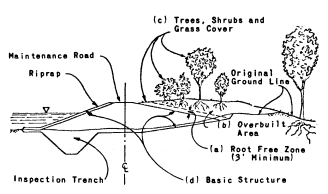
Figure 1.
Cross-sections of an urban levee showing:
a) root-free zone; b) overbuilt area; c) trees,
shrubs and grass cover; d) basic structure.
Vegetation and Levee Maintenance
The detrimental effects of vegetation on flood control levees have been recognized for centuries. Printed below are excerpts from a rare Spanish book, as translated by Amalio Gomez.[6] The book, "Hidrologia Historica del Rio Segura", deals with the struggles of the City of Murcia, Spain, from 1535 to 1879 against floods, droughts, and other calamities.
Murcia Levee Ordinance
1. It is hereby ordained that Murcia's levee shall not be swept by any person, with any type of broom, because the soil of which the levee is built will be blown away by the wind, and in the course of time the levee will lose height. Therefore, he who violates this ordinance shall be fined . . . The city's share [of the fine] shall be used to pay the wage of a levee patrolman.
2. No person shall plant any trees, including mulberry bushes and fruit trees, within ten paces of the toe of the levee, along the entire length of the levee, and on both sides of the levee . . .
3. All trees (see 2. above) located within the ten pace strips described, should be pulled out within thirty days of the publication of this ordinance . . .
4. No person, for any reason, shall farm within the land occupied by the levee with a plow, hoe, or other implement . . .
5. No person shall accumulate a pile of manure within 100 paces of the toe of the levee all along its length . . .
6. It is ordained that no cattle of any kind shall be permitted to walk along the levee crown, with or without an attendant; such cattle must walk the road built parallel to the levee for that purpose. Cattle may cross the
[6] Former Chief, Engineering Division, Sacramento District, US Army Corps of Engineers.
levee only at the paved cattle crossings. Owners of cattle found violating this act shall be fined . . .
7. Grass grown on the levee crown and side slopes shall not be cut or pulled by any person . . .
8. The levee shall not be used as a playground; no person shall damage it by making holes or otherwise. No damage shall be done to any improvements on the levee crown, such as statues, paintings, stone seats, housewalls, stone pavements and hermitages. Violators shall be punished . . . It is further ordained that if the patrolman hired by the city to patrol the levee and enforce these ordinances does not apprehend the violators, he shall be removed from office and appropriately punished. (Gomez 1976)
Each prohibition of the ordinance carried a penalty. The usual procedure was to divide the fine, giving one-third to the judge, one-third to the accuser, and one-third to the city. The ordinance was enacted by the City of Murcia on July 25th, 1737. It was approved by the Royal Council of Castilla, August 30th, 1737.
Corps of Engineers Regulations
The Code of Federal Regulations contains the CE regulations for the operation and maintenance of local flood protection works.[7] These regulations, as written, apply to flood control projects throughout the nation and are of necessity general in character.
With regard to vegetation, the regulations require that measures be taken to promote the growth of sod, exterminate burrowing animals, and provide for routine mowing of the grass and weeds and removal of wild growth and drift deposits. The regulations also encourage planting willows and other suitable growth on the river side of levees to retard bank erosion; they discourage activities which retard or destroy the growth of sod, such as burning grass and weeds.
CE has several regulations which further address vegetation and the operation and maintenance of levees. Excerpts from "Project Operations, Levee Maintenance Standards and Procedures" (US Army Corps of Engineers 1968) are presented below.
Maintenance Standards
The levees will be maintained as necessary to insure serviceability against floods at all times. Standards for accomplishing the foregoing are as follows:
A good growth of sod will be maintained where feasible with grass height from 2 inches to 12 inches, substantially free of weeds.
All brush, trees, or other undesirable wild growth will be removed from the levee embankment. Vegetation specifically planted for aesthetics or recreation purposes may remain.
Maintenance Procedures
Maintaining sod growth—Maintenance of a sturdy sod growth on levee embankments is highly important as sod is one of the most effective means of protecting the levee against erosion from rain, current and wave wash. Periodic mowing is essential to maintaining a good sod growth, and should be done at such intervals as necesssary to keep down weeds and other noxious growth and to prevent the grass height from exceeding 12 inches. The grass should be mowed to a height of 2 inches or more. The number of mowings required each season will depend on local conditions, but experience has indicated that in most parts of the United States two or more mowings are necessary each season where pasturing is not used. The last mowing of the season should be accomplished under conditions which will allow the grass to obtain a height of approximately 8 to 10 inches going into the winter season. Mowing should be performed to a distance of at least 5 feet beyond the toe of the levee or berm.
Burning grass and weeds will not be permitted in the levee maintenance program, except during appropriate seasons when it will not be detrimental to the growth of sod.
"Project Operations, Inspection of Local Flood Protection Projects" (US Army Corps of Engineers 1973) addresses items to look for during inspections. Some excerpts from that regulation are presented below.
Are trees and other growth which might jeopardize the stability or watertightness of the structure removed at regular intervals?
Have trees and undesirable growth been cleared from the levees and along side floodwalls?
Does brush cover or other growth interfere with inspection?
Are there any obstructions to vehicular passage along the crown of the levee?
Is sod cover on levees being encouraged?
Is there any unauthorized burning of grass and weeds?
Is sod cover mowed regularly?
[7] Code of Federal Regulations Section 208.10, Title 33, Chapter II. Part 208—Flood Control Regulations. Corps of Engineers, Department of the Army.
Is sod or other desirable cover fertilized and reseeded as necessary?
Is there an effective program for control of burrowing animals?
"Project Operation, Maintenance Guide" (US Army Corps of Engineers 1967) also contains information on levee maintenance. Appendix I of the regulation, "Inspection Guide and Maintenance Standards," contains the following information:
Close inspection (should be made) for settlement, sloughing, slides, erosion, condition of ground drainage, the presence of burrowing animals, the presence of debris, need of mowing, encroachments that tend to weaken levees, rutting of crown, depressions or other defects.
Keep embankments sufficiently smooth to permit mowing by power equipment. Newly filled areas shall be sodded or seeded.
Levees should be mowed with tractor-operated equipment to a height of 2 inches or more when the grass reaches a height of 5 to 7 inches or when excessive uneven growth of grass or weeds becomes unsightly. Reseeding and fertilizing is limited to kind and weight necesssary to sustain vegetative cover for the control of erosion by wind and water.
Figure 2 is an example of a levee where vegetation interferes with inspection.
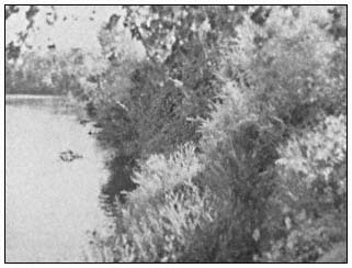
Figure 2.
Levee along Sutter Slough where dense
vegetation interferes with levee inspection.
Title 33 of the Code of Federal Regulations[5] also requires the CE to furnish local interests with an operation and maintenance manual for each flood control project (e.g., US Army Corps of Engineers 1955, 1959). The manual assists the responsible authorities in carrying out their obligations by providing information and advice on the operation and maintenance requirements of each project. Specific maintenance requirements that are applicable to an area are spelled out in special instructions in the manual for each project. This has been done, for example, in the special instructions contained in the "Standard Operation and Maintenance Manual for the Sacramento River Flood Control Project" (US Army Corps of Engineers 1955) which allow burning. Burning was allowed after the California Department of Public Works (DPW) in 1949 contended that due to the nature of the levee vegetation, burning weeds and brush during appropriate seasons should be allowed in order to determine danger to the levee such as slips and cracks and to permit the detection of holes caused by burrowing animals. Figures 3 and 4 present a good comparison between a burned levee and a mowed levee.
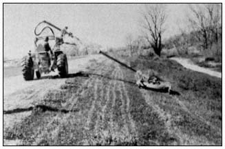
Figure 3.
Tractor-mounted hydraulically operated and controlled rotary
mower as utilized by the American River Flood Control District
(California Department of Water Resources 1973).
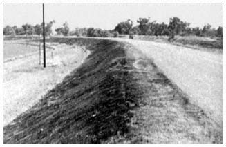
Figure 4.
Burned levee along the Sacramento River near Knights Landing.
Another example of special instructions in the "Standard Operation and Maintenance Manual for the Sacramento River Flood Control Project" (US Army Corps of Engineers 1955) deals with the provision in Title 33[5] which encourages growth
riverward of the levees to retard bank erosion. The special instructions in the manual expand on this provision and allow retention of brush and small trees on the waterward levee slope where desirable for preventing erosion and wave wash. The manual contains the specific requirements for maintenance of each project.
Others besides the CE recognize that vegetation can be detrimental to levees. In December 1954, a year before the disastrous flooding of Yuba City and Nicolaus due to a levee break (fig. 5), the RB and the DPW expressed concern about trees on levees. The following is extracted from an 8 December 1954 letter from the RB to the District Engineer, CE, Sacramento:
The Reclamation Board has through many years of experience found that the existence of trees on the river banks is a serious threat to the integrity of the levee system. In that respect the regulations of the Corps of Engineers require the removal of wild growth from levee banks and this agency is obligated to enforce these regulations. However, the Reclamation Board concurs in the view that trees constitute a menace to flood control works. Tree root systems penetrate levee sections, inducing seepage paths. Trees situated on the edge of the river banks that are uprooted by high winds, particularly when the banks are saturated, create craters in the sandy banks and levee sections rendering both of them susceptible to serious erosion during flood periods. Furthermore, the presence of trees on or adjacent to a levee often seriously interferes with routine maintenance operations such as slope dragging and control of weed cover.[8]
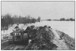
Figure 5.
Break in Feather River levee in Reclamation District 1001.
The following are excerpts from a letter dated 10 December 1954 from the DPW, Division of Water Resources, to the District Engineer, CE, Sacramento:
Through the years, large trees became established on the levee slope and the heavy superimposed load produced slip-outs when the relatively unstable bank and levee section became saturated. Wind action on trees also tends to loosen the embankment and accelerates slippage when moisture is present. Trees overhanging the water's edge tend to pull out and drop into the stream when pressure is released from saturated banks. Trees which are of sufficient size to offer resistance to the flow of water are undesirable in a levee slope. Fallen trees and bared roots caused scour, silting and eventual diversion of the current with the result that banks became undercut, additional trees are dislodged and serious levee slippages ensue.
Best maintenance practice dictates that the levee should be kept clear of trees and brush. However, in actual practice this condition is not fully obtained. In the sand levees below Sacramento, the presence of sod and light growth is not particularly objectionable and, in many instances, considered desirable. However, trees which attain large growth should never be permitted to become established on the levees. At locations where a wide berm exists between the bank of the river and the toe of the levee slope there is no objection to large trees if located in clear of the levee and riverbank.
The assumption that the trees along the banks of the Sacramento River have provided a stabilizing effect is contrary to the experience of the engineers in the Division of Water Resources and others familiar with the conditions along the Sacramento River. Most severe slip-outs in levees of the Sacramento River can be directly attributed to the presence of large trees which place a superimposed load on the relatively unstable embankment, in excess of the ability of the levee material to resist when saturated.[9]
Figures 6 and 7 are examples of some of the problems cited by the RB and the DWR.
[8] California Reclamation Board. 8 December 1954. Letter to the District Engineer, CE, Sacramento, concerning tree removal along both banks of the Sacramento River between Sacramento and Rio Vista.
[9] California Department of Public Works, Division of Water Resources. 10 December 1954. Letter to District Engineer, US Army Corps of Engineers, Sacramento, concerning tree removal along Sacramento River channels downstream from Sacramento.
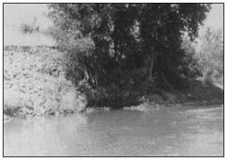
Figure 6.
Exposed roots and erosion around roots of tree
along Sacramento River near Knights Landing.
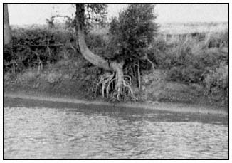
Figure 7.
Exposed tree roots along Sacramento River near Cranmore.
The State maintains some portions of the Sacramento River Flood Control Project under the supervision of the DWR, with costs being defrayed by the State. The DWR also has exercised supervisory powers over maintenance performed by local districts on Sacramento River Flood Control Project levees. Such supervisory controls were accomplished generally in conformance with DWR "Standard Maintenance Procedures" (California Department of Water Resources n.d.) and "Guide for Levee Maintenance" (California Department of Water Resources n.d.). The following is taken from these manuals:
Clearing of the levee slopes of all growth, other than grass, should be accomplished at the earliest opportunity and once cleared the area should be maintained in that condition.
Burning of vegetation on levee slopes and shoulders should be performed annually.
Cut and pile brush, trees, and other obnoxious growths.
Clear brush, trees and wild growth, other than sod, from the levee crown and slopes. Herbicides applied with suitable equipment, under proper control and conditions, have been successfully employed in eradicating pernicious growth of vegetation.
Contrary to the often expressed belief that growth of trees and brush is beneficial for protection of the levee slopes, long experience has demonstrated that this is in error for the following reasons:
Under wind and wave action the larger growths tend to pull at their root systems, causing them to uproot themselves, disturb the soil or rock revetment and permit accelerated erosion to take place. Fallen trees may also cause harmful current deflection and accumulate drift, which can compound the erosive action. Roots of large trees also attract burrowing animals to the protective shelter afforded.
Removal of such growth promotes a growth of sod or grass, the pliable roots of which tend to provide a soil binding net.
Some detrimental effects of vegetation were pointed out again in "Findings and Recommendations Based on the Inspection of the Delta Levees During October 1980" (Department of Water Resources 1980a). Excessive wild growth was considered detrimental because it interfered with visual inspection of levee sections suspected of being inadequate. The DWR recommended some selective clearing to increase the capability for levee inspection and floodfighting.
The importance of levee maintenance has long been recognized. In 1925, in his report to the RB concerning revised plans for the Sacramento River Flood Control Project (California Department of Public Works 1925), the State Engineer stated: "This project will be incomplete and the expenditures largely wasted without adequate provisions for maintenance."
The importance of adequate levee maintenance is also recognized in "California Flood Management: An Evaluation of Flood Damage Prevention Programs" (California Department of Water Resources 1980b), which includes the statements:
Levees are . . . the method [of flood control] with the greatest potential risk of failure . . . Such failure can be caused by high waters overtopping a levee or eroding a portion of a levee, or by excessive seepage through a levee. Also, very large trees can be uprooted, leaving excessive voids in a levee, which can accelerate levee destruction . . . The effectiveness of
any method of structural flood protection depends on the maintenance of the completed projects . . . Levees are the weakest part of a structural flood control program . . . Maintenance is a continuing responsibility with the objective of retaining the functional capability of the structures to store or carry storm flows according to their design . . . Levees are the most critical area in the maintenance of structural flood protection works.
The overriding concern of the CE, Sacramento District, has been ensuring the integrity of the flood control levees. Hence, adequate maintenance must provide a condition which will ensure the integrity of the systems when needed during flood periods. Encroachments which compromise the levee integrity or interfere with inspection, maintenance, and operation activities are detrimental to levee integrity.
Multiple-Purpose Levees
Previous information on levee maintenance was focussed on flood control purposes. Multiple-purpose levees have also been investigated.
On 1 July 1962, the DWR initiated the Pilot Levee Maintenance Study. This five-year study was conducted to conceive and test alternative methods of levee maintenance that would provide for multiple use of levees. In 1967, when the Pilot Levee Maintenance Study (California Department of Water Resources 1967) was completed, all levee maintenance costs were borne by flood control beneficiaries. The results of the study indicated that levee maintenance costs increase significantly when efforts are made to work around and save vegetation. The report on the study included the statement that the introduction of uses other than flood control will require sharing of levee maintenance costs among flood control and the added users in some manner proportional to the value received from multiple-purpose maintenance.
Altering maintenance practices to reflect concerns of other interests was also addressed in the "Preliminary Report to the California State Legislature on a Multiple-Purpose Levee System for the Sacramento-San Joaquin Delta (California Department of Water Resources 1970) and "Sacramento River Levee Revegation Study Final Report, 1968–1973" (California Department of Water Resources 1973). The findings again were that it costs more to maintain levees for multiple purposes, and that some alternative methods of costsharing need to be developed for multiple-purpose levee maintenance.
In 1967, the CE, Sacramento District, approved the adoption of "Levee Encroachment: Guide for Vegetation on Project Levees" (The Reclamation Board 1967) as a guide in the consideration of vegetation encroachments. The Sacramento District recognized fully that vegetation must be most carefully controlled in order to ascertain that the integrity of the levee system is not impaired.
In response to the findings of the DWR, AB 214 (Z'berg) was passed and became effective 1 January 1974. This bill[10] amended the California Water Code[11] to provide financial contributions from the state to local agencies for those costs associated with the operation and maintenance of project levees which are directly attributable to the planting or retention of controlled vegetative cover for wildlife, recreation, scenic, and aesthetic purposes, if the cost of maintenance is increased by such planting or retention. It has already been determined that vegetation was allowed on levees in accordance with the "Guide for Vegetation on Project Levees" (ibid .); this authority provided a method for funding the increased costs associated with preserving the vegetaion. Procedural requirements for this program were developed by DWR (The Reclamation Board 1974). The extent of implementation and funding of this program is unknown to the writer.
Continuous efforts are being made by DWR and RB to find and evaluate alternative construction methods and maintenance practices for flood damage reduction facilities which provide needed flood protection but are also responsive to environmental and aesthetic considerations. Some of these efforts are described in "Flood Control Project Maintenance and Repair 1980 Inspection Report" (California Department of Water Resources 1981).
One such effort involves using integrated pest management. The Center for the Integration of Applied Sciences of the John Muir Institute (JMI) has been working with the DWR since 1976 to develop and implement an integrated pest management program for the flood control levees of the Sacramento River (Center for the Integration of the Applied Sciences 1978). A major pest is the ground squirrel which is believed to weaken the levee structure by its burrowing. In assessing pest problems found on levees, particularly rodent control, the JMI has noted that lack of vegetation may enhance rodent populations. JMI is seeking to develop a vegetative management plan that would discourage rodent populations but not impede the ability of levee maintenance personnel to maintain the physical integrity of the levees. For investigation purposes, JMI selected vegetation which would not serve as a food source for ground squirrels or pocket gophers. JMI has also presented information on the movement of squirrels. Most squirrels remain within 33 m. (100 ft.) of their burrow entrances, although much farther movements have been observed. The ramifications of such selective
[10] Chapter 955, Statutes of 1973.
[11] Chapter 5, commencing with Section 8450, Part II, Provision 5 of the Calfornia Water Code.
plantings could be far-reaching if food sources for rodents are to be kept beyond the limits of the home range of squirrels.
Opportunities for Vegetation
The requirements for levee stability and the detrimental effects vegetation can have on flood control levees have been discussed. After taking these concerns into account, it is possible to outline the conditions under which, without reducing the flood protection provided by the levee systems, vegetation may be allowed on levees in the Sacramento/San Joaquin Valley. Such general guidelines are presented in the "Guide for Vegetation on Project Levees" (The Reclamation Board 1967), approved by CE, Sacramento District, in 1967. The basic guidance is that vegetation must be maintained in a controlled manner to ensure that it does not compromise the levee integrity or interfere with levee inspection, maintenance, operation, or flood-fight activities. The guide requires that the levee be oversized; this overbuilding provides for a root zone. The guide specifies minimum spacing intervals for trees and shrubs, the intent being to keep the levee slopes visible for inspection during low-flow and flood periods. The guide presents acceptable and unacceptable varieties of trees and shrubs—from the viewpoint of growth characteristics, impairment of inspection and maintenance, and potential impairment during flood-fight activities. The guide requires pruning of trees and shrubs so that inspection of the levees is possible.
There are opportunities for vegetation, including trees and shrubs, on project levees in the Sacramento/San Joaquin Valley. Vegetation is allowed, although the extent of vegetation that exists is often determined by the maintaining agencies and the underlying fee owners of the land. In cooperation with the RB, the CE, Sacramento District, has planted some vegetation on and adjacent to levees in the Sacramento/San Joaquin Valley. Where construction has been performed, the construction areas are seeded for dust and erosion control and aesthetic purposes with seed mixes suggested by fish and wildlife interests. Trees and shrubs have been planted where the levee is sufficiently oversized to provide a root zone, and riverward berm areas have also been planted. Figures 8, 9, and 10 show some of the planting that has been done.
Figure 8.
Planting trees on levee, Sacramento River near Freeport.
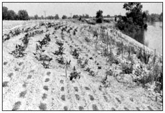
Figure 9.
Various species of vegetation planted along
Sacramento River levee near Elkhorn Park.
Figure 10.
Trees planted along Sacramento
River levee near Sacramento Weir.
There is presently significant emphasis on having vegetation on flood control levees. However, some levees are not suited to "riparian vegetation", when riparian vegetation is defined as that which requires free or unbounded water or conditions that are more moist than normal (Thomas 1979). Approximately 480 km. (300 mi.) of project levee are adjacent to the Sacramento River between Rio Vista and Ordbend. There are about 10,500 ha. (26,000 ac.) of land within the levee system along the Sacramento River in this reach. The levees occupy about 1,620 ha. (4,000 ac.) of land, the main river channel covers about
2,830 ha. (7,000 ac.), and the remaining 6,070 ha. (15,000 ac.) consist of berms, bars, banks, old oxbow channels and the like. Similar information listed by river reaches between Rio Vista and Ordbend is shown in table 1.
The area available within the levees for wildlife habitat or river aesthetics exceeds the area occupied by the levees almost four-fold. It is recognized that the levees along the Sacramento River downstream of Colusa (River Mile 144) are closely aligned to the main river channel. There are means available, consistent with good flood control practice, for allowing vegetation, including trees and shrubs, on these levees. Where the existing levees are sufficiently oversized, the "Guide for Vegetation on Project Levees" (The Reclamation Board 1967) in conjunction with the program authorized by AB 214 could be used to encourage vegetation on levees. In other areas, the levees could be overbuilt to accommodate such vegetation. Upstream of Colusa, there is ample land within the levees that could be acquired for development of vegetation areas. Such areas would also be better suited to riparian vegetation than the levee embankments which are most often set back from the river. The conditions along the lower San Joaquin River and Tributaries Project levees are similar to those along the Sacramento River levees.
The better levees are maintained, the less likely it is that problems will develop during flood periods; poor maintenance presents a much greater risk of levee failure. Regardless of vegetation, the primary concern in maintaining levees is to assure the flood protection. However, there is a feeling by some that some degree of risk associated with vegetation on levees can be tolerated when considering aesthetics and desires for wildlife habitat. The subject of risking the protection of lives and property that is presently provided by federal flood control projects goes beyond the scope of this paper. However, if such risks are to be taken, the degree of risk should be established and the concurrent liability determined.
| |||||||||||||||||||||||||||||||||||||||||||||
Literature Cited
California Department of Public Works. 1925. Sacramento river flood control project revised plants. 170 p. The Reclamation Board, State of California, Sacramento.
California Department of Water Resources. n.d. Standard maintenance procedures. 7 p. California Department of Water Resources, Sacramento.
California Department of Water Resources. n.d. Guide for levee maintenance. 8 p. Division of Design and Construction, California Department of Water Resources, Sacramento.
California Department of Water Resources. 1967. Pilot levee maintenance study, Sacramento-San Joaquin Delta. Bulletin No. 167, California Department of Water Resources, Sacramento. 24 p.
California Department of Water Resources. 1970. Preliminary report to the California State Legislature on a multiple-purpose levee system for the Sacramento-San Joaquin Delta. 21 p. California Department of Water Resources, Sacramento.
California Department of Water Resources. 1973. Sacramento River levee revegetation study, final rport, 1968–1973. District Report, Central District, California Department of Water Resources, Sacramento. 19 p.
California Department of Water Resources. 1980a. Findings and recommendations based on the inspection of delta levees during October 1980. 23 p. California Department of Water Resources, Sacramento.
California Department of Water Resources. 1980b. California flood management: an evaluation of flood damage prevention programs. Bulletin 199, California Department of Water Resources. Resources, Sacramento. 277 p.
California Department of Water Resources. 1981. Flood control project maintenance and repair 1980 inspection report. District Report, Central District, California Department of Water Resources, Sacramento. 35 p.
California Department of Water Resources. 1982. Directory of officials of flood control, reclamation, levee, and drainage districts, and municipalities. California Department of Water Resources, Sacramento.
Center for the Integration of the Applied Sciences. 1978. Making the transition to an integrated pest management program for ground squirrels on DWR levees. 114 p. Center for the Integration of the Applied Sciences, John Muir Institute, Berkeley, Calif.
Gomez, A. 1976. Hidrologia historica del Rio Segura. Information Bulletin, Sacramento District, US Army Corps of Engineers, Sacramento, California.
The Reclamation Board. 1967. Levee encroachment: Guide for vegetation on project levees. 4 p. California Department of Water Resources, Sacramento.
The Reclamation Board. 1974. Joint interim procedures for the administration of a state program of financial assistance for maintenance of controlled vegetation on project facilities. 9 p. California Department of Water Resources, Sacramento.
Thomas, J.W. (ed.). 1979. Wildlife habitats in managed forests: The Blue Mountains of Oregon and Washington. USDA Forest Service Agricultural Handbook No. 553, Washington, D.C. 512 p.
US Army Corps of Engineers. 1955. Standard operation and maintenance manual for the Sacramento River flood control project. 32 p. plus 62 supplements. South Pacific Division, Sacramento District, US Army Corps of Engineers, Sacramento, Calif.
US Army Corps of Engineers. 1959. Standard operation and maintenance manual for the lower San Joaquin River levees, Lower San Joaquin River and Tributaries Project, California. 32 p. plus 13 supplements. South Pacific Division, Sacramento District, US Army Corps of Engineers, Sacramento, Calif.
US Army Corps of Engineers. 1967. Project operation, maintenance guide. Engineering Regulation 1130-2-303. Department of the Army, Office of the Chief Engineer, Publications Depot, Alexandria, Va.
US Army Corps of Engineers. 1968. Project operations, levee maintenance standards and procedures. Engineering Regulation 1130-2-335. 4 p. Department of the Army, Office of the Chief Engineer, Publications Depot, Alexandria, Va.
US Army Corps of Engineers. 1972. Engineeering and design, landscape planting at floodwalls, levees and embankment dams. Engineering Manual 1110-2-301. 10 p. Department of the Army, Office of the Chief Engineer, Publications Depot, Alexandria, Va.
US Army Corps of Engineers. 1973. Project operations, inspection of local flood protection projects. Engineering Regulation 1130-2-339. 9 p. Department of the Army, Office of the Chief Engineer, Publications Depot, Alexandria, Va.
US Army Corps of Engineers. 1978. Engineering and design, design and construction of levees. Engineering Manual 1110-2-1913. 180 p. Department of the Army, Office of the Chief Engineer, Publications Depot, Alexandria, Va.
Riparian Vegetation on Flood Control Project Levees
Constraints and Opportunities[1]
Lee W. Carter and Gene L. Anderson[2]
Abstract.—Efforts are being made to find and evaluate alternative construction methods and maintenance practices that are responsive to environmental and esthetic considerations in conjunction with flood control needs. Although some constraints on vegetation on levees are necessary, progress is being made to reach a compromise between the environmentalists and the flood control project builders and operators to allow riparian vegetation on and adjacent to flood control project levees.
Introduction
Can riparian vegetation on flood control project levees be managed differently in the future than it has been in the past? What constraints on vegetation are necessary to maintain the integrity of flood control project levees?
The answers to these questions are complex and controversial. This paper is primarily based upon experience with levees in the Central Valley of California.
Background
Maintenance of flood control project channels and levees has come under considerable public criticism in the last several years. Some of this criticism can be attributed to the lack of environmental consideration on the part of the maintaining agencies. Some of the criticism is because the public fails to acknowledge the primary purpose of the levees. Public criticism is often triggered by removal of riparian vegetation and its replacement with rock bank protection.
In recent years, the California Reclamation Board and the Department of Water Resources (DWR) have advocated retention of a greater amount of riparian vegetation on and adjacent to flood control project levees. The US Army Corps of Engineers (CE) has resisted relaxation of present flood control project maintenance standards because of the high potential for loss of human life and property associated with levee failures. The CE has expressed particular concern about the increased wild growth developing in the rock revetment sites on the Sacramento River flood control project levees.
The differences between guidelines for allowable vegetation on levees proposed by the Reclamation Board and those in the operating manuals prepared by the CE have received considerable attention during the past three years. The staff of the CE and that of the DWR have jointly proposed a revised guide for allowable vegetation consistent with Title 33, Code of Federal Regulations. This revised draft of present guidelines was circulated for review within the DWR, CE, other interested State agencies, and local levee maintaining agencies. The local maintaining agencies and the South Pacific Division of the CE expressed opposition to relaxation of the CE's standards. The Department of Fish and Game expressed concern that the proposed guide does not adequately encourage the retention and protection of riparian vegetation.
The next step will be to submit the proposed guide to the Reclamation Board for its recommenmendations considering the comments that have been received.
Constraints on Vegetation on Levees
First, it is useful to discuss briefly the reasons for restricting vegetative growth on levees.[3] Most levees were constructed for one purpose—to protect the adjacent land from flooding. Early levees were constructed by local landowners. Later State and Federal governments
[1] Paper presented at the California Riparian Systems Conference. [University of California, Davis, September 17–19, 1981].
[2] Lee W. Carter is Chief, Data and Operations Branch, Central District, Department of Water Resources. Gene L. Anderson is Senior Engineer, Department of Water Resources, Sacramento, California.
[3] For more information on this subject, see Nolan (1981).
assisted in providing funds and expertise to upgrade the integrity of flood control projects. For the most part, the levees were considered single-purpose flood control structures. They were designed as dams to withstand the hydrostatic pressure and relatively high velocities of flow exerted on the levees during high water.
The design, construction, and maintenance standards developed by the CE were designed to protect human life and property. The State of California gave assurances to the Federal government that the levees would be maintained to the standard outlined in the operation and maintenance manuals prepared by the CE for project levees. The most economical and efficient way to inspect the levees was to restrict the amount of vegetation so that the levee slopes could be inspected from the levee crown. Most inspections are made from an automobile moving along the levee at about 5 mi. per hr. or 1 mi. per 12 min. If the inspector were required to stop and spend time inspecting levee slopes on foot, the inspection time could easily be tripled. Under the present inspection procedures, the State is spending around $200,000 per year for inspections. Maintenance and flood fight activities also are easier to perform without wild growth on the slopes. Therefore, many maintaining agencies annually mow, burn, or spray vegetation. The maintaining agencies then fill eroded areas with soil or rock, exterminate burrowing rodents, and maintain levee heights to the design level.
In some cases, the local maintaining agencies have cleared more vegetation than is required by the CE standards; in other cases, they are doing less than is required by standards. For example, the minimum-size levee on a major stream is 20-ft. minimum crown width, a design freeboard of 3 ft. to 5 ft., and slopes of 3:1 horizontal to vertical on the waterward levee slope, and 2:1 horizontal to vertical on the landward side of the levee. On smaller tributary streams, the minimum crown width is 12 ft., freeboard 3 ft., and the same side slope requirements. According to CE engineering manuals, this basic levee structure must be root-free except for grasses and low-growing, shallow-rooted groundcover plants. In certain areas, brush and small trees may be retained on the waterward levee slope to prevent erosion, wave wash damage, and for environmental values.
Unrevetted Levees
Although the Federal regulations still require the basic structure to be root-free, many levees are larger than the minimum standard levee. Where adequately overbuilt levees exist, trees and shrubs can be allowed to remain on the levee slope. However, to facilitate inspection of the levees and flood fighting efforts, spacing requirements are considered necessary. Selective clearing to satisfy spacing requirements is expensive.
The magnitude of the expense of retaining vegetation is difficult to evaluate. The expense would vary depending on the extent and type of vegetation and the present maintenance practices. Many local maintaining agencies contend they cannot provide for the additional expense required for selective clearing. No sources of funds, except for the unfunded Z'Berg Bill (Water Code Section 8450, etseq .), have been identified to subsidize local maintaining agencies for the increased cost of maintaining riparian vegetation.
Critics of the CE standards argue that the standards are too stringent and that vegetation can be a deterrent to erosion of the levee slopes. In some instances, their argument may be valid; however, the standards were developed to protect levees under adverse soil-type and foundation conditions, erosional forces, and problems associated with trees and shrubs.
The causes of levee failures are difficult to document. Failures have been attributed to levee subsidence because of foundation conditions, rodent activities, and caving of the levee from erosion. No levee failure has been attributed directly to the existence of riparian vegetation on the levee slopes. However, vegetation that hinders the local maintaining agency in performance of adequate maintenance increases the risk of levee failure. Consequently, frequent and adequate inspection of levee slopes is considered imperative to a good maintenance program. Restrictions on vegetation species, spacing, and pruning are, therefore, considered necessary.
In general, unacceptable vegetation species either: 1) provide a food supply for rodents; 2) are detrimental or destructive and difficult to control or eradicate; or 3) are characteristically thorny or intrusive, such as roses, blackberries, bamboo, and vines.
The proposed revised guidelines provide that spacing between trees or clumps of trees, shrubs, or clumps of trees and shrubs (up to 6 ft. in diameter), shall be no closer than 25 ft. The 25 ft. were considered an average inter-tree or inter-clump distance between trees on levees. Also, spacing encourages the tree to branch out rather than grow tall. Space requirements are for three general reasons: 1) to facilitate inspection of the levee; 2) to make flood fights and repairs less difficult; and 3) to encourage trees to develop a good root system and to branch out rather than grow tall. Tall trees have a greater tendency to be blown over.
Revetted Levees and Berms
The present CE guidelines prohibit growth of trees and shrubs in rock revetment on a standard levee section. Under the proposed revised guide, trees and shrubs are allowed in the revetment on either levees or berms when the distance from the landward shoulder measured at design freeboard level to the top of the revetment is 150 ft. or greater. When the stream velocity is less than 5 ft. per sec. and the channel is relatively straight, this distance can be reduced to 75 ft.
The rationale for this conservative guideline is: 1) revetment has been placed in areas where erosion has been a problem; and 2) flow pattern irregularities caused by trees and shrubs can cause displacement of the rock and failure of the revetment.
Opportunities for Vegetation on Levees and Berms
As mentioned earlier, many levees along the major streams are large enough to accommodate vegetation under the proposed revised vegetation guidelines.
Unrevetted Levees
Most unrevetted levees that have two-lane surfaced roads on the crown exceed the 30-ft. width requirement at freeboard that is proposed in the revised vegetation guide for retention of vegetation. Also, the waterward slope of the basic levee under the proposed revision has been changed from 3:1 horizontal to vertical, to 2:1 horizonal to vertical. This change increases the area at the waterward base of the levee where roots are allowed. This would provide for considerably more trees and shrubs near the waterward toe of the levee.
Unrevetted Berms
The proposed vegetation guide provides that where a berm exceeds 10 ft. in width, vegetation is allowed with no requirement for species, spacing, height, or pruning unless special conditions require some restriction.
Low Rock Revetment
In the case of the Steamboat Slough bank protection work, the CE constructed a 10-ft. berm just above the normal low water level and placed rock on the face of the berm. This is an example of innovative design of a levee to provide a condition where vegetation can be allowed. This design is consistent with the criteria for vegetation on berms established in the proposed revised vegetation guide. It should be recognized that this special construction feature increased the cost of providing flood control. In this case the CE and the State provided the funds to pay the extra capital costs. The local maintaining agency will be responsible for maintenance.
Low rock was also placed by the CE in several reaches of the Sacramento River downstream from Sacramento as early as 1940. In many locations vegetation has grown in and above the rock. Normal deterioration of the rock has resulted in some areas and repairs are needed, but very few problems have been attributed to the vegetation. The rock has reduced erosion and has not been significantly displaced in 40 yrs., indicating that low rock has been successful under these flow and soil conditions.
Funding to Protect Riparian Vegetation
Erosion of berms and levees is continuing at a high level, resulting in the loss of riparian vegetation at an alarming rate. Federal and State funds to protect levees and berms are decreasing. We will discuss briefly the status of two programs used in the past to help retain vegetation on levees and berms, the Sacramento River Bank Protection Program, and the 1973 Z'Berg Bill, codified as Section 8450, etseq ., of the Water Code.
The Sacramento River Bank Protection Program began in June, 1963. Under this program, the CE repaired levees along the Sacramento River flood control project. Costs were shared, with the Federal Government paying two-thirds and the State paying one-third. Under Phase I of this program, a large amount of riparian vegetation was removed from the project levees. Due to environmental concerns, the CE (under Phase II of the program) received authorization to spend up to 10% of the project costs to mitigate the loss of streamside vegetation resulting from the bank protection work. The presently authorized work under Phase II is nearing completion. Work on Steamboat Slough, in Unit No. 36, is the last work authorized for construction under Phase II.
The continuation of Phase II bank protection is conditioned on Congressional authorization of mitigation for Phase I. Even though Phase II provides for environmental consideration, the Secretary for Resources has not authorized State participation with the CE on additional units of bank protection work under this phase until the replacement of wildlife habitat lost during construction of Phase I has been authorized.
Conclusion
We believe more vegetation can be retained on and adjacent to flood control levees if: 1) the levee section is designed as a multi-purpose structure, that is, enlarged to provide a zone for roots outside the basic structure required for flood control; and 2) if the levee and vegetation are adequately maintained. Both of these conditions require additional funding. The question arises: who is willing to pay? In this time of austere budgets, support will be required from many sectors to obtain the high priority necessary for funds to protect riparian vegetation on and adjacent to flood control levees.
Literature Cited
Nolan, Michael F. 1981. Vegetation on Corps of Engineers' project levees in the Sacramento-San Joaquin Valleys, California. In : R. E. Warner and K.M. Hendrix (ed.). Proceedings of the California Riparian Systems Conference. [University of California, Davis, September 17–19, 1981]. California Water Resources Center Report No. 55. University of California, Davis.
The Role of Vegetation in an Integrated Pest Management Approach to Levee Management[1]
Sheila Daar, William Klitz, and William Olkowski[2]
Abstract.—Encouraging appropriate vegetation complexes on levee slopes maximizes levee safety, and improves wildlife habitat, recreational opportunities, and aesthetic amenities. This contrasts with standard levee maintenance practices which annually destroy vegetation on levees, thereby exacerbating a series of maintenance problems, and reducing environmental quality.
Introduction
Thousands of miles of levee systems border California's major riparian zones. Though constructed from engineered fill soils and designed to restrict floodwaters to designated channels, these levees nonetheless offer opportunities to protect and enhance the state's riparian ecosystems (Davis etal . 1967).
The extensive soil area represented by the levee system supports a considerable biomass of vegetation which in turn serves as potential harborage and food sources for many riparian wildlife species (Sands 1977). In addition, many levee reaches serve as buffers, separating waterside berms bearing remnant strands of riparian vegetation from landside agricultural and urban development. See figure 1 for illustrations of various levee configurations.
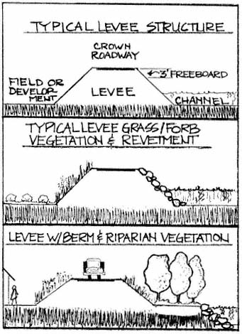
Figure l.
Several possible levee and levee/berm configurations
and their associated vegetations.
Standard levee maintenance practices, however, generally assume vegetation on levee slopes is a hindrance to the prime purpose of levees, namely flood protection (US Army Corps of Engineers 1955). Under such practices, vegetation is removed each year to permit inspection of the levee surface. This practice of yearly vegetation removal and frequent soil disturbance creates and aggravates a series of levee maintenance problems ranging from erosion to ground squirrels. These maintenance practices also severely limit the opportunity to utilize levees for such secondary functions as wildlife habitat, riparian vegetation enclaves, and aesthetic and recreational amenities.
[1] Paper presented at the California Riparian Systems Conference. [University of California, Davis, September 17–19, 1981].
[2] Sheila Daar is Staff Horticulturalist, William Klitz is Research Coordinator, and William Olkowski is Co-Director at the Center for the Integration of Applied Sciences, a division of the John Muir Institute, Berkeley, California.
This paper describes a vegetation management program for the levee system which not only has the potential for enhancing levee safety and improving maintenance cost-effectiveness, but which affords opportunities to bring levee maintenance practices more in line with needs to improve environmental quality and protect our dwindling riparian resources.
This approach to vegetation management has been a focus of the Integrated Pest Management (IPM) program under development for the Department of Water Resources (DWR) for the past four years by the Center for the Integration of Applied Sciences (CIAS), a division of JMI, Inc. IPM is a decision-making process for analyzing and solving pest problems and features mixes of tactics and strategies compatible with environmental quality.
Utilizing the IPM approach to problem solving, CIAS staff discovered a relationship between traditional levee maintenance practices and the onset and increase of weed and rodent pests, considered major problems by DWR.
Traditional Levee Maintenance
The cornerstone of traditional levee maintenance practices is the mandate to remove levee vegetation annually in order to inspect levee slopes (ibid .). Inspections are designed to detect damage, such as cracks, slumps, seeps, erosion, or rodent burrows, which could weaken levees during periods of high water.
The major methods utilized in levee vegetation removal include burning, surface dragging, mowing, and applying herbicide. (Brush removal in channels to improve channel capacity is another major maintenance activity, but discussion of that topic is beyond the scope of this paper.)
The dominant role vegetation removal plays in levee maintenance is illustrated by budget figures compiled for the 523 km. (325 mi.) of levees and 24,300 ha. (60,000 ac.) of channels maintained by DWR Sacramento and Sutter Maintenance Yards. As detailed in figure 2, activities associated with vegetation removal consumed 57% of the 94,000 labor hours involved in maintenance in 1978. Activities included brush cutting (27,848 hours), spraying (14,315 hours), mowing (5,164 hours), burning (3,542 hours), fire guarding (1,872 hours), and tree management (582 hours). (Environmental costs due to pesticide residues in water, air pollution from burning, loss of wildlife habitat, and reduced recreational and aesthetic values are not available.)
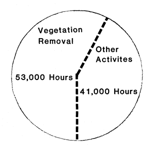
Figure 2.
DWR labor hours involved in vegetation removal,
1977–78 (total maintenance budget $2.6 million.)
Consequences to the Levee Plant Community of Vegetation Removal
One of the major effects of annual vegetation removal appears to be a shift in the species of plants growing on the levees. Plant ecology literature (Weaver and Clements 1938; Frenkel 1977) indicates that systematic yearly soil disturbance creates conditions favoring broad-leaf species over grasses.
Baseline vegetation transects in five levee study areas (Daar etal . 1979) showed that broad-leaf plant represented 76% of the total species present, although two annual grasses (Avenafatua and Bromisrigidis ) sometimes dominated the stands. The competitive advantage which yearly soil disturbance accords broad-leaved species may explain the presence of dense stands of thistles and other weeds such as puncture vine (Tribulusterrestris ) and field bindweed (Convolvulusarvensis ) which are considered undesirable on levees because they are more difficult to remove than grasses.
Once established, these "weedy" species often maintain their presence and density over many years. Herbicides are applied to these broad-leaf plants (as well as to unwanted grasses such as Johnson grass [Sorghumhalopensis ]) to increase broad-leaf susceptibility to the annual burning and mowing operations. Table 1 shows the amount of herbicide (active ingredient) applied in 1979 and 1980, as well as projected use in 1981. The relationship of soil disturbance to presence of broad-leaf species indicates a cycle of maintenance practices which may be requiring an ever-increasing rate of herbicide use.
Routine use of herbicides on levee vegetation also promotes a shift in plant species composition—often in a direction not desired. For example, in many locations yearly application of triazine herbicides to levee crown roadways has
| ||||||||||||||||||||
suppressed the relatively preferred wild oat (Avena fatua ) which formerly populated the top of the levee slope. Removal of the wild oat has allowed establishment of perennial weed species such as Bermuda grass (Cynodondactylon ) and field bindweed, which are less susceptible to the herbicides (Frenkel 1977). Field bindweed is an important agricultural pest, and Bermuda grass encroaching on crown roadways is considered a major pest by levee maintenance personnel who feel it interferes with grading practices necessary to keep crown roadways clear and passable during the winter.
Relationship of Vegetation Removal to Presence of Erosion, Slumps, and Cracks in Levees
Most vegetation removal on levee slopes occurs during the summer and early fall, leaving levee surfaces relatively bare until germination of winter seedlings with the first rains. In areas treated with herbicides, soil sterilants may keep sections of slope bare for several seasons.
The ability of levee slopes to resist the erosive forces of wind and water is severely reduced in the absence of a densely rooted stand of vegetation (Enlow and Musgrave 1938). This is particularly true on the waterside slope where rainfall, wave wash, scouring, and other hydraulic forces place erosive pressure on levees.
The absence of vegetation on slopes during the heat of the summer may also exacerbate the development of cracks in the levee structure. Vegetation contributes to the even drying of soils after saturation by winter flows (Mathews and Cole 1938; Satterlund 1972). Removal of vegetation may alter that process, resulting in differential soil settling and drying, which can cause cracks.
Ground Squirrels and Levee Vegetation
Vegetation removal activities of levee maintenance cause changes in the plant composition and structure on the levees. These activities also have a major impact on ground squirrels, the most important animal pest on levees.
Ground squirrels can be significant pests on levees due to the extensive network of underground burrows these animals create. Their channeling may weaken levee structure during floods and increase the likelihood of a levee break. The population biology and behavior of rodents make them good candidates for control through habitat modification (Davis 1972), and ground squirrels may be susceptible to this strategy.
The relationship of ground squirrel population density to the degree of soil disturbance has long been noted. For example, Linsdale (1946) observed that ground squirrel numbers rose and fell with the extent of overgrazing on pasture lands. High squirrel populations are characteristically associated wih barren ground, outcrops, or elevated areas (Owings and Borchert 1975), and nearby food sources. Lack of vegetation permits high visibility for the squirrels, which aids in social communication and predator detection (Owings 1977). With the construction of levees and the traditional maintenance practices associated with them, people have inadvertently created prime ground squirrel habitat which is lacking only an enriched food source, often supplied by adjacent agriculture.
Figure 3 shows the results of a detailed study on a section of levee which demonstrated the relationship of ground squirrel density to vegetation and other environmental features. The number of burrows is indicative of the population size of squirrels and is a direct indication of the damage to levees caused by the squirrels.
Squirrel burrows on a 3.2-km. (2-mi.) stretch of levee encompassing various environments were counted in the late summer of 1980, after the levee had been burned. The squirrels' particular attraction to areas of barren ground was demonstrated by the high burrow densities observed in the area where overgrazed pasture extended up onto the side of the levee. Burrow numbers on the levee dropped where the fence line ended.
A second strong determinant of ground squirrel distribution is availability of food sources. Exceptionally high burrow densities were present near the walnut orchard. The area immediately adjacent to the walnut orchard, which had 583 holes per km. (932 per mi.), had been fumigated earlier in the season, so counts may actually have been depressed there. Areas within the squirrel foraging range of the walnuts on both sides of the levee also had very high burrow counts. (It was impossible to count burrows in the area of stone revetment on the water side opposite the orchard, although squirrel densities were clearly high there. The high counts in areas near the orchard showed the enhanced effect on squirrel densities produced by both disturbed slopes and nearby food.)
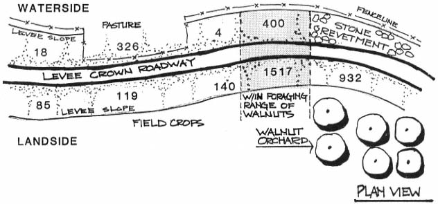
Figure 3.
Distribution of ground squirrels on 3.2 km. (2 mi.) of levee at East Yolo Bypass, Yolo County, California,
August, 1980. Counts are in number of burrows per levee mile. Before burning, yellow star thistle
(Centaurea solstitialis ) and wild oat (Avena fatua ) comprised the dominant vegetation on much of
the otherwise undistinguished levee slope. The linear distance along the levee is not drawn to scale.
Areas lacking both nearby walnuts and the disturbed surface of the overgrazed pasture had lower burrow counts. In these areas, a weaker propensity of squirrels to burrow on land- versus water-side slopes may have been demonstrated. That is, there is a propensity to burrow on landside slopes, but that propensity is less pronounced in areas which are away from orchards and overgrazed pastures.
Vegetation on levee slopes during the summer and fall may be particularly important in habitat management of ground squirrels. During this period, young, first-year animals are actively dispersing, seeking new area in which to settle (Dobson 1979). Slopes covered with vegetation at this time of the year will be much less attractive to migrating squirrels than those freshly denuded by annual vegetation removal practices.
The traditional approach of annually burning levee slopes followed by dragging to obliterate burrow openings and smooth the levee surface improves the quality of ground squirrel habitat. In contrast, a program of deliberately maintaining certain vegetation on levee slopes may tend to discourage squirrel colonization. The tactic of revegetating levee slopes with appropriate plant species should be integrated into an active squirrel control program if permanent population reduction is to occur.
An Integrated Pest Management Approach to Levee Vegetation
An IPM approach to vegetation management offers a way out of the traditional dilemma of levee maintenance practices which exacerbate weed and rodent pests. Furthermore, this method shows promise as a means of achieving the objectives of maximum levee safety while simultaneously improving environmental quality of riparian areas.
Traditional approaches to levee maintenance have a single objective—that of flood safety. In contrast, the IPM approach recognizes flood safety as the primary maintenance objective but places high value on other goals including improvement of wildlife habitat and recreational opportunities, enhanced aesthetics, and reduced pesticide use. At the level of implementation, the main points at which the approaches differ are in the way in which vegetation is viewed and the process by which maintenance decisions are made.
Despite the wide variation in biotic and abiotic conditions of various levee reaches, traditional maintenance practices have tended to give all levee reaches equal attention and treatment. Thus, a uniform policy of slope clearing to facilitate inspection is implemented irrespective of characteristics of the levee vegetation. By contrast, the IPM approach gives more recognition to the uniqueness of each levee stretch in
the belief that improved practices can be developed which both maximize flood safety and improve environmental quality.
When reduced to their basic structural forms, levees can be defined as "fill slopes." When viewed in this manner, both engineering (US Army Corps of Engineers 1978) and biological (Lines etal . 1978) expertise would agree that vegetation can and does play a key role in stabilizing these slopes against the erosive forces of wind, water, temperature fluctuation, and damage by animals, humans, or vehicles.
Damage to levees due to erosion, cracking, slumping, seeps, etc., may originate in soil type, construction techniques, seismic action, burrowing rodents, water pressure, maintenance practices, or other forces. Whatever the origin of the problem, the presence of vegetation holding the soil mass together can help reduce (and in some cases, prevent) the onset or impact of such problems.
Thus, protection and encouragement of certain vegetation-types on levee slopes can be seen as an important tool in maximizing the structural integrity—and therefore the safety—of these structures. Should a conflict appear to arise between the presence of vegetation and the need to inspect the levees, a site-intensive levee monitoring program offers a solution (fig. 4).
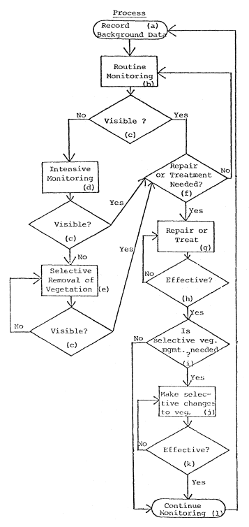
Figure 4.
Diagram showing a levee slope monitoring
process. Key variable is slope visibility.
Under an IPM vegetation management system, information on current site or pest conditions is integrated with historical data on the construction and maintenance history of a levee reach. Site conditions are evaluated through use of a variety of monitoring techniques and record-keeping systems which vary in intensity, depending on a priority assigned to a given site. Utilizing the monitoring data, injury and action levels are established for the vegetation, and selective treatments are chosen. Spot treatments, selected from mechanical, cultural, biological, or chemical controls, are timed to minimize side effects on non-target organisms. Strategies and tactics are evaluated for long-term effectiveness and cost.
Utilizing this system, the maintenance manager has greater flexibility when it comes to the apparent conflict between vegetation and inspection of levees. By prioritizing sites to be monitored, those with no significant history of maintenance or other problems can receive a less intense level of monitoring, freeing maintenance personnel to focus major monitoring attention on areas with chronic flood history or maintenance problems. (This situation may occur defacto under the traditional approach but is not recorded, planned, or approached in a systematic manner.)
Ideally, levee inspections occur just before, during, and just after flood season (i.e., November–March each year). Under the IPM system, spring inspections (which detect damage from winter flows) should be timed to occur before spring grasses have grown more than one foot tall. By shifting existing maintenance personnel to inspection/monitoring roles in early spring, it
should be possible to thoroughly monitor most sections of levee prior to dense growth of vegetation. If vegetative growth becomes too dense to detect potential levee damage, selective removal of that vegetation can occur. If damage is found, repairs can be made. If warranted, the vegetation at that site could be removed periodically, or vegetation more suited to the inspection and maintenance needs at that site could be encouraged.
Encouraging Appropriate Vegetation on Levees
A major strategy in an IPM program for levees is the development of practices which select for and encourage certain existing grass species and low-growing broad-leafed plants which reinforce the structural integrity of levees by reducing erosion and ground squirrel habitat. Examples of candidate species include salt grass (Distichlisspicata ); creeping ryegrass (Elymustriticoides ); perla grass (Phalaristuberosa 'Hurtiglumis') and saltbush (Atriplex spp.).
Under some circumstances it may be appropriate to introduce new species to the levees (Daar etal . 1979), particularly in areas adjacent to residential subdivisions, where concerns about the relation of levee management to fire danger, recreation, and aesthetics are the focus of attention. Five candidate species for replacement vegetation in urban areas are showing promise as relatively low-growing, dense, low-maintenance slope covers in test plots at two levee locations near Sacramento. These species include: sageleaf rockrose (Cistus salvifolius ), Cleveland sage (Salviaclevelandii ), Australian saltbush (Atriplexsemibaccata ), dwarf coyote brush (Baccharispilularis 'Twin Peaks No. 2'), and Noel grevillia (Grevillianoellii ).
Benefits of IPM Vegetation Management
The benefits of a selective vegetation-management system will be most evident during the flood season. The condition of levees at any given site will be known in intimate detail due to the data recorded by the monitoring program. This results in greater predictability of a given levee reach when under flood stress. At sites with chronic maintenance problems or flood histories, vegetation on the land side of the levee (the side visible during high water) will have been selectively managed to retain its rootmass while restricting its height, thus maximizing the stability of the slope as well as its visibility in case of a flood fight. Decisions regarding setting of priories and scheduling work, deployment of labor and materials, and evaluation of efficacy of maintenance efforts will be aided by the data collected by the monitoring process.
Other benefits of particular relevance to the riparian system would include reduction in the use of pesticides, more extensive wildlife habitat, enhanced recreational opportunities, and an increase in the aesthetic quality of the levee environment.
In conclusion, an IPM approach to managing levee vegetation shows promise as a method for achieving the dual objectives of maximum levee safety and improved environmental quality.
In recognition of this potential, the DWR is moving to implement new IPM practices including more intensive levee-monitoring and record-keeping systems, development of injury- and action-level concepts, and use of selective vegetation-management techniques to encourage the presence of certain grasses and other vegetation compatible with multiple-use management objectives. It is hoped that these and other IPM practices will become adopted Department-wide and serve as a model for the state's 7,000 local water districts, whose activities have a profound impact on California's dwindling riparian resources.
Literature Cited
Daar, Sheila, Nancy Hardesty, Rhodes Hileman, Donna Michaelson, and William Olkowski. 1979. Vegetation checklist of potentially useful plant species for introduction into DWR level ecosystems. p. 42–59. In : Third IPM report to Division of Planning, Department of Water Resources. 120 p. Center for the Integration of Applied Sciences, John Muir Institute, Berkeley, Calif.
Davis, D.E. 1972. Rodent control strategy. p. 159–171. In : Pest control: strategies for the future. 376 p. National Academy of Sciences, Washington, D.C.
Davis, Larry C., Sam Ito, and Philip Zwanck. 1967. Pilot levee maintenance study. California Department of Water Resources, Bull. 167. Sacramento.
Dobson, F.S. 1979. An experimental study of dispersal in the California ground squirrel. Ecology 60:1103–1109.
Enlow, C.R., and G.W. Musgrave. 1938. Grass and other thick growing vegetation in erosion control. pp. 595, 623. In : Soils and men. Yearbook of Agriculture. US Department of Agriculture.
Frenkel, Robert E. 1977. Ruderal vegetation along some California roadsides. 163 p. University of California Press, Berkeley.
Lines, Ivan L. Jr., Jack R. Carlson, and Robert A. Corthell. 1978. Repairing flood-damaged streams in the Pacific Northwest. In : R.R. Johnson and J.F. McCormick (tech. coord.). Strategies for the protection and management of floodplain wetland and other riparian ecosystems. [Callaway Gardens, Georgia, December 11–13, 1978.] USDA Forest Service GTR-WO-12, Washington, D.C. 410 p.
Linsdale, J.M. 1946. The California ground squirrel. 475 p. University of California Press, Berkeley.
Mathews, O.R., and John S. Cole. 1938. Special dry-farming problems. p. 683. In : Soils and men. Yearbook of Agriculture. US Department of Agriculture.
Owings, D.H., and M. Borchert. 1975. Correlates of burrow location in Beechey ground squirrels. Great Basin Naturalist 35:402–404.
Owings, D.H., M. Borchert, and R. Virginia. 1977. The behavior of California ground squirrels. Animal Behavior 25:221–230.
Sands, Anne (ed.). 1977. Riparian forests in California: their ecology and conservation. Institute of Ecology Pub. No. 15., University of California, Davis. 122 p.
Satterlund, Donald R. 1972. Wildland watershed management. 279 p. Ronald Press, New York, N.Y.
US Army Corps of Engineers 1955. Standard operations and maintenance manual for Sacramento River flood control project. 32 p. US Army Corps of Engineers, Sacramento District, Sacramento, Calif.
US Army Corps of Engineers 1978. Interim report to Congress. The streambank erosion control evaluation and demonstration act of 1974. 41 p. US Army Corps of Engineers.
Weaver, John E., and Frederick E. Clements. 1938. Plant ecology. 320 p. McGraw-Hill Co., New York, N.Y.
Experimenting with Levee Vegetation
Some Unexpected Findings[1]
Thomas H. Whitlow, Richard W. Harris, and Andrew T. Leiser[2]
Abstract.—Vegetation has long been recognized as a component of levee systems which can be managed to protect and enhance the flood control function. The additional contribution of vegetation to the biological and recreational roles which levees perform make it an especially attractive component of the system to manipulate. Despite a lengthy history of experiments with levee vegetation, little progress has been made toward developing a management strategy which recognizes vegetation as a resource rather than a liability. It is suggested that scientific experimentation will not remedy the situation. Changes in current policy will be necessary before even existing information can be applied.
Introduction
"A functional, factorial approach to plant ecology" (Major 1951) is a conceptual design for field experiments in plant ecology which permits environmental factors to be isolated from one another and their relationships to the vegetation to be identified. Major identifies five independent variables as determinants of vegetation in the mathematical expression:

|
This general model is familiar to anyone engaged in experimentation. A problem or phenomenon is isolated (in this instance, vegetation) as a dependent variable, while independent variables are manipulated so that their effects on the dependent variable can be measured and evaluated.
Between July 1978 and July 1980 the authors, through the Department of Environmental Horticulture at the University of California, Davis, investigated the potential for using vegetation as an agent for erosion control in the tidal zone on levees in the Sacramento/San Joaquin Delta (Whitlow etal . 1979, 1980). As plant scientists, we focused on plant/environment interactions rather than engineering or policy considerations. In our experiments we strove to mimic the structural and floristic organization of the native riparian vegetation in Delta levees. In the terms of Major's model, we manipulated the topographic and organismal factors by deciding which species were to be planted and where they were to be planted in relation to tide levels. Additionally, we reviewed the pertinent literature to identify species which would be suitable components of levee vegetation.
This paper reviews the work we conducted for the California Department of Water Resources (DWR), identifies problems with current approaches, and suggests directions for future efforts to manage levee vegetation.
Historical Overview
Existing Delta Vegetation
Over the past 120 years the Sacramento/San Joaquin Delta has been converted from over 200,000 ha. of marsh and overflow lands to a dryland agricultural environment (Shlemon and Begg 1975). What remains of the natural vegetation is confined to narrow bands of marsh and riparian forest on levees and unreclaimed islands in the
[1] Paper presented at the California Riparian Systems Conference. [University of California, Davis, September 17–19, 1981.]
[2] Thomas H. Whitlow is Research Associate, Urban Horticulture Institute, Cornell University, Ithaca, New York; Richard W. Harris and Andrew T. Leiser are Professors, Department of Environmental Horticulture, University of California, Davis.
channels. Though in a highly modified environment very different from the pristine landscape, the natural vegetation has persisted or reconvened itself in a form that is remarkably like the original (Atwater 1980; Atwater etal . 1979; Thompson 1958). The constriction of a vast marsh to narrow, "riparian surrogate" communities (Dennis etal . 1983) increases the relative importance of the remaining vegetation to the present-day Delta ecosystem.
Two conspicuous environmental gradients are apparent in the natural Delta vegetation. The first is a small-scale flood gradient which exists in the vertical dimension on levee faces and other areas subject to tidal flux. The second is a large-scale salinity gradient which exists across the Delta. This second gradient fluctuates seasonally and from year to year, depending on freshwater inputs. The historic limits of this saltwater intrusion have been reduced and its gradient steepness increased by the construction of upstream dams (California Department of Water Resources, Central District 1981). While the salinity gradient is important to consider in long-range levee planning, the flood gradient is more immediately important to levee revegetation.
The natural vegetation on Delta levees may be arranged along a very apparent, though poorly understood, flood-tolerance axis (table 1). The nature of flood tolerance is complex and will not be discussed here. For present purposes it is adequate to recognize that frequency, depth, and duration of flooding decreases with increasing elevation, whether on a levee face or an island.
| ||||||||||||||||||||
At the lower end of the intertidal zone is Scirpus californicus . Immediately uphill is Scirpus acutus . These two species are the familiar tules. Overlapping the tules but often extending well above the high-tide line are Typha spp. (three species of cattail are found in the Delta, with T . latifolia being the most common) and Phragmitesaustralis (reed). Several species of rushes (Juncus spp.) and one iris (Irispseudacorus ) are quite common and may dominate at the mean high-tide level.
It is at this level that woody species appear. Willows (Salix spp.), dogwood (Cornusstolonifera ), and buttonbush (Cephalanthusoccidentalis ) form dense thickets at or just above the high-tide line. Above the zone of tidal flux but still within the reach of floods are species of the riparian forest: white alder (Alnusrhombifolia ), cottonwood (Populusfremontii ), sycamore (Platanusracemosa ), California black walnut (Juglanshindsii ), and valley oak (Quercuslobata ).
Thompson (1957) has gleaned from the early chronicles that the natural levees in the pre-reclamation Delta were "stabilized" by the presence of vegetation. Though we cannot assess how stable these levees might have been, present-day evidence suggests that they might have been quite stable. Figure 1, taken on Medford Island facing south along the Stockton Deep Water Channel, illustrates a well-developed plant community whose structure and species composition closely resembles the preceding textual decription. The levee has withstood the same conditions which have breached nearby, intensively maintained levees in areas less exposed than the deep water channel. Interestingly, the DWR rates the Medford Island levee as "very poor," a category shared by Frank's Tract, which was never reclaimed after a flood in the 1930s (California Department of Water Resources, Central District 1981). Further, the Medford Island levee clearly violates Title 33 of the Federal Code because flood-fighting activities would be hampered by the presence of trees on the levee crown. Yet the levee appears to be quite stable.
Revegetation of Levees and Similar Sites
In the course of our investigations for DWR, we identified a number of information sources applicable to our levee revegetation interests. These often were not part of the published literature, and retrieval was therefore difficult. These sources are described elsewhere (Whitlow etal . 1979). However, a brief summary of
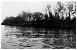
Figure 1.
Well-developed plant community growing on a levee along
the Stockton Deep Water Ship Channel, near Medford Island.
the kinds of sources available in 1979 is instructive. We identified four species lists specifically aimed at levee revegetation in California, compiled by various state and federal agencies or their consultants. Over 100 species were identified on these various lists as being suitable for use on levees.
In addition to these lists, seven experimental studies have been undertaken by the US Army Corps of Engineers (CE), DWR, USDA Soil Conservation Service (SCS), and the University of California, Davis, in collaboration with the US Department of Agriculture and various state and federal resource agencies. These studies identify an additional 100 species and also report on experimental outcomes, including survival, growth, and in some cases, costs. Two studies are especially worthy of mention because of their original scope and because they are extant and available for ongoing observation. These are the DWR Pilot Levee Maintenance Study (California Department of Water Resources 1967) and the CE Monument Bend planting on the Sacramento River (Morris 1976). Since our 1979 review, we have conducted three out-planting experiments, and the John Muir Institute has planted several experimental sites as well. We think it fair to conclude that an adequate, publicly available information bank exists which could serve as the basis for levee vegetation planning. It should also be noted that a companion literature for engineering treatments exists (Keown et al . 1977; US Army Corps of Engineers 1978) in which numerous applications of physical protection in conjunction with plant material are described.
Revegetation Research at Davis
Details of research conducted by the authors may be found elsewhere (Whitlow etal . 1979, 1980). Brief summaries are included here to indicate the scope and findings of the research.
Fall, 1978 Plantings
The objective of this planting was to identify species and planting techniques suitable for application in the intertidal zone of levees. The ultimate goal was a vegetative replacement for riprap. The DWR indicated that the engineering ideal would have the characteristics of aquatic "astroturf": dense, low-growing, and able to stabilize eroding banks without resorting to mechanical means. Accordingly, we utilized several native Eleocharis species (spikerush) (table 2) which had these characteristics. Tules, willows, and buttonbush were also planted in an attempt to generate basic information on native species normally occurring on levees. Such information could be used to tailor levee plantings to mimic natural vegetation. We planted two sites: 1) a freshly dredged and graded levee on Webb Tract, and 2) a series of eroding coves on Mandeville Island. We hoped to answer several specific questions:
1) which species survive?
2) at what depth of tidal inundation is optimum survival achieved?
3) is planting best conducted before or after refacing of levees?
We planted in the fall when water temperatures were warmest, on the assumption that root growth would be faster at this time than in the spring.
Survival was very low (table 2). The freshly faced levee on Webb Tract quickly changed from a 3:1 slope with neat planting rows to a steeply eroding headwall. What had been the lower edge of the intertidal zone washed away, and with it many of our plants.
The rooted woody cuttings and Eleocharis planting on Mandeville Island did not wash away. Instead, the local reclamation district riprapped the site, after observing no conspicuous growth in February 1979. (Our planting occurred in October, 1978.) We discovered this alteration during a periodic inspection and had had no prior notice that riprapping was scheduled. Indeed, site selection was done in collaboration with the reclamation district. Some quantitative survival data were salvaged and are included in table 2, but clearly the value of the experiment was compromised.
Despite the difficulties, several conclusions can be drawn and are worth stressing. First, small planting units like peat pots and gallon-can plants are not suitable for intertidal plantings, even if the material is rhizomatous and rapidly spreading, unless the material is well anchored. Second, there appears to be little advantage in planting rooted woody material. Again, this is partly related to the vulnerability of the planting unit. A 1-m. willow wand stuck into the mud has a better chance of establishment than a 0.2-m. rooted willow cutting in a pot. Third, a modicum of physical stability
| ||||||||||||||||||||||||||||||||||||||||||||||||||||||||||||||||||
must exist on the levee bank before plants can be established. While we were able to establish some willows and tules which are extant on Webb Tract, this did not constitute an acceptable survival rate for practical use. Lastly, the importance of enlisting the active support of collaborators and their agents (reclamation districts, district engineers, and farm supervisors) was made very clear. These people are not used to experiments. They expect results and may not have the patience or understanding to coexist with an experiment on their property.
Spring, 1980 Plantings
Armed with the experience gained from our first round of experiments, we undertook a second experiment on Terminous Tract (Whitlow etal . 1980). The emphasis was on using locally harvested material (table 3, 4, and 5) in conjunction with erosion control fabrics to provide immediate stability and help anchor the plants (fig. 2). Again, the goal was to replace rock as the primary erosion control agent. Tules and willow cuttings were locally available and had the physical properties appropriate to the scale of the problem. We also experimented with spikerush (Eleocharis ) again, this time using a sod mat contained within a polypropylene bag to facilitate anchoring. Observations in the Delta suggested that a naturalized iris was capable of rapid spreading in the tidal zone. Accordingly, a small number of these plants were installed. Finally, we seeded with alkalai bulrush (Scirpusrobustus ) and water grass (Echinochloacrusgalli ) both on and under our fabric-protected plot and on adjacent, freshly laid riprap. The seeds are inexpensive and commercially available and have obvious advantages over vegetative propagules for large-scale applications.
The erosion control fabrics (Stabilenka and Enkamat, available from American Excelsior Company) were selected as a "soft" alternative to rock. We wanted the bank to stay in place during the period of establishment, and we also wanted our plants and seed held in place during high tides. These fabrics are far lighter than rock and thus easier to handle without heavy equipment; they may have the added advantage of being more available than rock in the future. While the fabric has been successfully applied in the Netherlands and the eastern United States, it has received little attention in California.
All of these details in our second experiment were modifications of our first approach in an effort to refine techniques and develop a practical demonstration. One last refinement was added: we enlisted the participation of the local
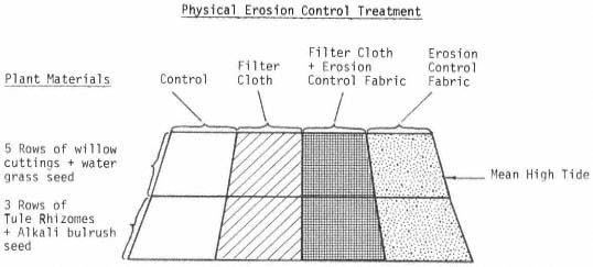
Figure 2.
Schematic diagram of main plot, 1980 planting.
| ||||||||||||||||||||||||||||||||||||||||||||||||||||||
| |||||||||||||||||||||||||
| ||||||||||||||||||||||||||||||
reclamation board. With the help of the district engineer, a site was selected which could be used for at least two years without disturbance. The reclamation district contributed a backhoe and operator for site preparation.
The planting was undertaken in May, 1980, and establishment data were submitted to DWR in July (table 3, 4, 5). The more important data, however, were the long-term survival data to be collected in the spring and summer of 1981. Had we succeeded in establishing an erosion-resistant vegetation or had we merely put a few plants on a levee? The prospects for answering this question were promising: the levee was still there, and we had a viable cohort of survivors going into the second season. We were unable to assess second season performance, however, because in February the site was riprapped. There was a difference between this and our previous experience in that the reclamation district knew exactly what it was doing when the decision was made to install riprap revetment. It had not been part of the maintenance plan, but when long-awaited rock became available, the expedient choice was to take all that could be obtained. The authors were not contacted prior to the riprapping because the engineer in charge was uncomfortable about having to back out of his original agreement.
In view of our experiences with levee revegetation experiments, we conclude that the de facto policy practiced by reclamation districts is that rock is the preferred form of bank protection. It is not a matter of experimentation, it is a matter of preference, and in the absence of a clear, functional policy to the contrary coming from a public agency, this preference becomes policy.
Discussion
The basic findings of our research are that while vegetation can be established on levees, these efforts do cost money and may not achieve the engineering goal of stopping erosion. This is especially true in the intertidal zone where severe conditions hinder plant establishment. Yet, experience indicates that even in the tidal zone, with proper anchoring several native species can be established. Whether this pattern would continue over the long run remains to be seen.
We began with an ecological model to identify factors affecting the establishment and survival of plants on levees. The unexpected finding was that this was not the right approach to the problem. While there are directions future research could take to overcome planting and survival problems, we question whether such research is appropriate at this time. Research models like ours which focus on environmental variables will continue to produce "results," but they will fail to deal with the real problem of levee maintenance.
Such models start with the wrong assumptions and therefore answer questions which skirt the central issue. Consider the following evidence. Both the work co-sponsored by DWR and the SCS, reported in Bulletin 167 (California Department of Water Resources 1967), and the Monument Bend study conducted by the CE have been neglected. When we inquired about touring these sites, no one in any of the organizations was familiar enough with the studies to even precisely locate the sites, much less assess the long-term performance. The studies were essentially forgotten, and there was no formal provision for follow-up to determine long-term survival, maintenance cost, and erosion protection at the sites. Such data are vitally important if policies are to be affected by research. Without a policy context, study results cannot be applied and are quickly forgotten.
From our own experience, it has been difficult to follow an experiment for even the first year owing to major site modifications undertaken by collaborating reclamation districts. We understand that experiments conducted by the John Muir Institute have suffered in similar fashion. The specific difficulties may range from benign neglect, through poor communication and misunderstanding of experimental goals, and ultimately to preemptive exercise of local management imperatives. The net effect, however, is the same: we never progress beyond a preliminary stage in solving the levee maintenance problem. If science and technology are not providing solutions, then what will?
We suggest that this problem is not amenable to scientific hypothesis testing, but rather falls into the policy arena. Scientific findings may contribute to an understanding of how ecosystem components interact, but may not provide clear-cut answers to complex issues of public administration. To paraphrase John Clark (1978) of the Conservation Foundation, science deals with verifiable principles based on natural laws, while resource administration deals with policies consistent with fiscal and political realities. The clear articulation of an ecological principle (for example, that riparian ecotones represent a large compartment in an energy flow model of an ecosystem) does not translate clearly into a policy. The policymaker may decide to conserve natural riparian systems or to substitute artificial systems, in the form of sewage sludge ponds covered with water hyacinth and populated by mosquito fish. Net energy flow may be the same in both cases, though the alternatives are radically different. "Science" contributes to the achievement of either alternative.
The general problem outline which emerges here is by no means unique to levees in California. McCarthy (1976) and Ranwell (1979) describe identical problems in coastal zone management in the United States and Great Britain. The difficulties they identify are:
1) the conflict between economic and environmental needs;
2) establishing common ground between administrators and ecologists;
3) gathering and handling large amounts of scientific and planning data; and
4) translating the results into field action (Ranwell 1979).
It appears we are not alone. Yet these difficulties are not insurmountable, and we are optimistic. For levee vegetation, items 2 and 3 have been accomplished to some degree already. The long history of levee vegetation research and the recent conference on the future of the Delta are positive indications that common ground has been established, and that it is extensive. The DWR has a capable professional staff equal to the task of assimilating existing information. This leaves us with items 1 and 4. These are human problems involving fiscal and logistic constraints. More data on tule mortality will not result in progress in these areas because they involve public policy. The time is upon us to develop a new policy for riparian zone management on levees.
This is especially true for the Delta, where if something is not done soon, we are going to lose the whole system. This process will be costly and frustrating to all involved, but then so is the existing statusquo . Talking with the CE, DWR, the reclamation districts, and people in the Legislature leads us to conclude that no one is happy with the present situation. It would appear, then, that procrastination is not in anyone's best interest.
Although the following guidelines are not derived from our research, we offer them to facilitate the development of a new levee policy. We are adopting a "consider the problem solved" approach that vegetation on levees is desirable.
1. Retain existing vegetation wherever possible. It is much easier and cheaper to manage existing vegetation than to replant. This is especially true of intertidal plants.
2. Be realistic and flexible in deciding where and what to retain. A bramble patch may not be worth preserving if the consequence of preservation is probable levee failure or degradation of higher-quality habitat.
3. Especially in the Delta, this higher quality-habitat exists on unreclaimed channel islands. Protecting delta levees with rock and other mechanical means will help preserve these islands, first by ensuring that they remain islands in narrow channels rather than in a 200,000ha. lake with enormous wind fetch, and second, by minimizing the need for constant channel dredging which literally pulls the foundation from under these islands.
4. Do a complete, thorough job of levee restoration. This includes removing vegetation such as blackberries the season before work is anticipated, as well as designating vegetation to be retained or planted.
5. Establish priorities for levee work. The present situation pits reclamation districts against one another for contract rock and dredgers. The result is less efficient use of resources.
6. Provide reliable, ongoing financial and planning assistance to levee maintenance districts. An uncertain, inadequate financial assistance program like the on-again-off-again Way Bill encourages mistrust, cynicism, and contempt of government by landowners.
7. Establish a native plant nursery for riparian species, especially tules. Provide this material free or at cost, along with planning expertise, to landowners.
8. Actively pursue revision of Title 33 of the Code of Federal Regulations, which sets the flood control standards followed by the CE. These regulations are more applicable to the Mississippi River and are internally confusing about the status of vegetation.
Until there is a clear mandate to manage levees as a multi-functioning resource, they will continue to be managed only as flood control structures. We believe that sufficient information presently exists to sustain a policy of multiple-use levees. Once this determination is made, the political and fiscal steps toward implementation will follow. Is this a simplistic approach to a complex, burdensome, expensive problem? We think not. Similar decisions in the past are models for our present conclusion. Consider the decision to landscape hundreds of miles of California highways for primarily aesthetic reasons. In addition to aesthetics, there are compelling biological and structural imperatives for levee maintenance. The decision should be an easy one to make. There is still the opportunity to make the decision; this luxury may not always be with us.
Acknowledgments
This research was supported by grants from the DWR. Use of brand names is for identification purposes only and does not imply official endorsement.
Literature Cited
Atwater, B.F. 1980. Attempts to correlate Late Quaternary climatic records between San Francisco Bay, the Sacramento-San Joaquin Delta, and the Mokelumne River, California. Ph.D. Thesis, University of Delaware, Newark. 277 p.
Atwater, B.F., S.G. Conard, J.W. Dowden, C.W. Hedell, R.L. MacDonald, and W. Savage. 1979. History, landforms, and vegetation of the estuary's tidal marshes. p. 347–385. In : T.J. Conomos (ed.). San Francisco Bay: The urbanized estuary. 493 p. Pacific Division, American Association for the Advancement of Science, San Francisco, Calif.
California Department of Water Resources. 1967. Pilot levee maintenance study: Sacramento-San Joaquin Delta. Bulletin 167, California Department of Water Resources, Sacramento. 24 p.
California Department of Water Resources, Central District. 1981. Delta water supply and quality. p. 30–37. In : The future of the Delta. [Sacramento, Calif., March 16–17, 1981.] Sponsored by the Resources Agency, California Department of Water Resources and University Extension, University of California, Davis.
Clark, J.R. 1978. Science and the conservation of riparian systems. p. 13–16. In : R.R. Johnson and J.F. McCormick (tech. coord.). Strategies for protection and management of floodplain wetlands and other riparian systems. [Callaway Gardens, Georgia, December 11–13, 1978.] USDA Forest Service GTR-WO-12, Washington, D.C. 410 p.
Dennis, N.B., D. Ellis, J.R. Arnold, and D.L. Renshaw. 1983. Riparian surrogates in the Sacramento/San Joaquin Delta and their habitat values. In : R.E. Warner and K.M. Hendrix (ed.). California Riparian Systems. University of California Press, Berkeley, Calif.
Keown, M.P., N.R. Orwalt, E.B. Perry, and E.A. Dardean, Jr. 1977. Literature survey and preliminary evolution of streambank protection methods. Technical Report H-77-9, US Army Engineer Waterways Experiment Station, Vicksburg, Miss. 258 p.
Major, J.M. 1951. A functional, factorial approach to plant ecology. Ecology 32:392–412.
McCarthy, J. 1976. Coastal conservation in the U.S.A., some experience from the eastern states. Winston Churchill Trust Fellowship Report.
Morris, R. 1976. Monument Bend plantings review. Internal document, US Army Corps of Engineers, Sacramento District, Sacramento, Calif. 99 p.
Ranwell, D.S. 1979. Strategies for the management of coastal systems. p. 515–527. In : Ecological processes in coastal environments. First European ecological symposium and 19th symposium of the British ecological society. Blackwell Scientific, Oxford.
Shlemon, R.J., and E.L. Begg. 1975. Late quaternary evolution of the Sacramento-San Joaquin Delta, California. p. 259–266. In : R.P. Suggate and M.M. Cresswell (ed.). Quaternary studies. 320 p. The Royal Society of New Zealand, Wellington.
Thompson, J. 1958. The settlement and geography of the Sacramento-San Joaquin Delta, California. Ph.D. Dissertation, Stanford University, Palo Alto, Calif. 551 p.
US Army Corps of Engineers, Sacramento District. 1978. Reconnaissance report. Sacramento River and tributaries bank protection and erosion control investigation. 64 p. US Army Corps of Engineers, Sacramento, Calif.
Whitlow, T.H., R.W. Harris, and A.T. Leiser. 1979. Use of vegetation to reduce levee erosion in the Sacramento-San Joaquin Delta. 4 p. plus appendices. California Department of Water Resources, Sacramento.
Whitlow, T.H., R.W. Harris, and A.T. Leiser. 1980. Use of vegetation to reduce levee erosion in the Sacramento-San Joaquin Delta. Annual progress report. 15 p. California Department of Water Resources, Sacramento.
Riparian Surrogates in the Sacramento/San Joaquin Delta and Their Habitat Values[1]
Nona B. Dennis, Douglas Ellis, John R. Arnold, and Diane L. Renshaw[2]
Abstract.—The distribution and condition of riparian vegetation in the Sacramento/San Joaquin Delta has been highly modified during 130 years of land reclamation, construction and maintenance of the present levee system, and conversion of the land to agricultural cultivation. A variety of vegetation complexes with partial riparian attributes exist under a few natural, but primarily induced conditions in the Delta, providing some of the wildlife values associated with historic Delta riparian vegetation. These examples of modified riparian communities suggest that compromises will be necessary to achieve wildlife values that are compatible with flood control requirements and agricultural land use in the Delta.
Introduction
In January, 1979, a team of individuals undertook a year-long study of wildlife habitats in the Sacramento/San Joaquin Delta. The study was funded by the USDI Fish and Wildlife Service (FWS) and co-directed by the California Department of Fish and Game (DFG) and the FWS. The study culminated in the Sacramento/San Joaquin Delta Wildlife Habitat Protection and Restoration Plan (California Department of Fish and Game 1980) whose principal objectives were to:
1. document the wildlife habitat resources of the Delta, based on a year-long avian census and mammal survey as well as on available data, and to describe the human demands and activities which affect them;
2. seek more effective ways—both technical and institutional—to protect and enhance existing wildlife habitats or restore those that have disappeared from the Delta; and
3. present the policies and interests of the DFG and FWS with respect to protecting the wildlife resources of the Delta.
This paper is an informal summary of information in the Sacramento/San Joaquin Delta Wildlife Habitat Protection and Restoration Plan. It also presents the senior author's observations concerning the circumstances under which "surrogate" riparian communities have developed in the Delta and are presently managed, and the opportunities for their protection and enhancement or restoration as partial but valuable riparian wildlife habitats.
The "legal Delta" (California Water Code Sec. 12220) encompasses 2,986 km2 (1,153 mi2 ) or 298,800 ha. (738,000 ac.) (fig. 1). Prior to 1850, when reclamation began, the Delta was largely a marshland of about 161,900 ha. (400,000 ac.) surrounded by approximately 121,500 ha. (300,000 ac.) of slightly higher lands and shallow backswamps behind natural alluvial levees (Thompson 1957). With the completion of reclamation in 1930, the Delta was transformed into 60 major leveed islands totalling 182,000 ha. (450,000 ac.) of primarily agricultural land, more than 800 islets, and 1,130 km. (700 mi.) of waterways lined with 1,709 km. (1,062 mi.) of levees. A number of urban settlements are situated on the periphery of the Delta, but the predominant land use is agricultural.
The Sacramento/San Joaquin Delta Wildlife Habitat Protection and Restoration Plan surveyed all of the evident wildlife habitat-types represented in the Delta, including agricultural, urban, and other "developed" habitats. Vegetation, physiography and land use were used as
[1] Paper presented at the California Riparian Systems Conference. [University of California, Davis, September 17–19, 1981].
[2] Nona B. Dennis is President, Madrone Associates, Environmental Consultants, Novato, Calif. Douglas Ellis is Field Ornithologist, Madrone Associates. John R. Arnold, PhD., is Professor Emeritus of Zoology, California State University, Sonoma, Rohnert Park, Calif., and Senior Consultant, Madrone Associates. Diane L. Renshaw is Senior Consultant, Madrone Associates.
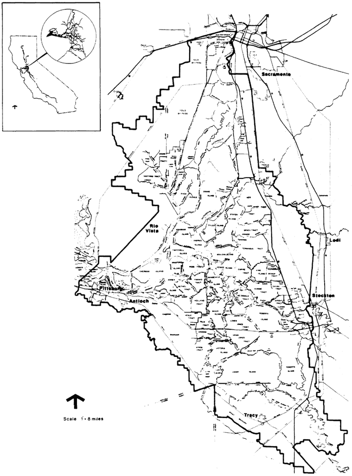
Figure 1.
The Sacramento/San Joaquin Delta.
bases for classifying habitats as they occur under present conditions, taking into account that agricultural practices (e.g., crop selection, irrigation methods) can profoundly change habitat conditions from year to year.
During the study it was apparent that several Delta habitat-types, both on and off levees, have riparian attributes (terrestrial adjacency to free waters and/or substrate with high soil moisture). However, few areas in the Delta still support historic communities of riparian species (cottonwood, white alder, western sycamore, ash, valley oak) that can be classified as riparian woodland or forest according to conventional criteria. As with many managed waterway systems, riparian vegetation exists in the Delta under sufferance and in many variations. The variations (i.e., "surrogates") are nonetheless worthy of attention, since they demonstrate considerable wildlife value and, in an area managed principally for flood control and agriculture, may offer among the few opportunities in the Delta for useful terrestrial habitat for many wildlife species.
Previous Work
Much attention in the past several decades has been focussed on the disappearance of riparian vegetation from many parts of the Delta, primarily in connection with levee construction and maintenance practices. There have been few ecological or floristic studies.
Most ecological investigations of riparian vegetation of the Sacramento River stop in the vicinity of Clarksburg, Yolo County, where the major native stands of Sacramento Valley riparian forest first appear (Thompson 1957). To our knowledge, only one analysis of structure and floristics of riparian vegetation of the Sacramento Valley extends study sites into the northern Delta, to include Stone Lake in the Sacramento River flood basin and Delta Meadows on Snodgrass Slough, as examples of relatively unmodified natural condition (Conard etal . 1977). The study characterizes riparian vegetation in terms of succession related to fluvial processes. This approach is generally valid but is not entirely useful when applied to Delta riparian vegetation. The extent of early vegetation and continuing manipulation of land, water, and vegetation in the Delta imposes an entirely new set of rules governing succession, even though familiar successional seres can still be seen throughout the Delta.
Whitlow etal . (1979) studied the role of natural and introduced riparian vegetation in retarding levee erosion. The research specifically addressed problems of establishing emergent species at the fluctuating water line. This study also provided an overview of the problems of maintaining vegetation on levees in the Central Valley (lower Sacramento River) and surveyed experimental levee planting projects conducted by the US Army Corps of Engineers (CE) and the California Department of Water Resources (DWR). The study concludes that revegetation of Delta levees is technically feasible and can be compatible with flood control objectives, if species and location are carefully considered.
Jepson (1893) catalogued species growing on natural levees along the lower Sacramento River. Mason (1957) studied aquatic and emergent species in the Delta's tidal wetlands extensively. Atwater (1979) reported on the distribution of dominant species and flora of six "pristine" Delta islets in pursuing the question of what vascular plants might have inhabited the freshwater reaches of Pleistocene estuaries. In so doing, he demonstrated the subtlety of the ecotone between "wetland" and "riparian" conditions in much of the prereclamation Delta, a condition which we feel bestows distinctive riparian attributes on the Delta.
The only complete and current mapping of wetland and terrestrial vegetation-types in the Delta was done by the CE (US Army Corps of Engineers 1979) at a scale of 1" to 1,000'. Delineation followed the FWS wetlands classification system (Cowardin et al . 1979). The system was based on a hierarchy of habitat variables: morphology (riverine, palustrine, lacustrine, etc.); vegetation-type (herbaceous, emergent, etc.); substrate (mud, sand, cobble, etc.); and salinity regime. Delta riparian vegetation under this classification falls primarily into one category: viz . "palustrine forested," or "riparian forest of broad-leaved deciduous vegetation, 6 m. or more in height" (ibid .). This riparian "type" compares with the R1 (large woody vegetation) and R1v (valley oak woodland) classifications used by the Central Valley Riparian Mapping Project (Central Valley Riparian Mapping Project 1979). A second category can be considered riparian, although CE maps do not specifically apply that term: viz . palustrine scrub/shrub, "dominated by woody vegetation less than 6 m. in height, with broad-leaved deciduous plants" (ibid .). This category compares with the R2 (low woody vegetation) used by the Central Valley Mapping Project (ibid .). The CE applies several other FWS categories to cover Delta "wetland" and "emergent" types. These generally compare with R3 (herbaceous vegetation) and M (marsh) used in the Central Valley Riparian Mapping Project.
The Sacramento/San Joaquin Delta Wildlife Habitat Protection and Restoration Plan adapted the FWS system, as used by the CE in mapping the Delta, to cover wildlife habitat designations which are more familiar and to express a wider range of riparian-like conditions.
A more detailed structural and floristic analysis of the diverse contemporary manifestations and wildlife use of riparian, or quasiriparian, vegetation in the Delta would be useful and might provide guidance with respect to vegetation, given the apparent constraints of flood
control and agricultural operations. The present paper does not fill this gap. It suggests, however, that the highly modified condition of the Delta, and its distinctive mixed estuarine and riverine origins and characters, have produced communities which have at least some if not all of the attributes of classic riparian zone vegetation, as well as many of the same plant species, and many of the same wildlife values.
Past and Present Distribution of Riparian Vegetation in the Delta
The Sacramento/San Joaquin Delta is an inland triangular network of waterways formed by the rising of sea level through the Carquinez Strait between 7,000 and 11,000 years ago to meet the alluvial fans and outflows of the Sacramento, San Joaquin, Cosumnes, and Mokelumne Rivers and smaller tributary streams (Atwater 1980) (fig. 1). Both rivers and tides have shaped the land and soils of the Delta (fig. 2). Peat soils derived from tule marshes occupy most of the level, low-lying central part of the Delta. Mineral-rich alluvial soils deposited by the rivers entering the Delta predominate on the periphery. Low natural alluvial levees defined the water courses throughout much of the Delta prior to reclamation, but today only vestiges of natural levees remain, the more massive man-made levee system having obscured these natural levees long ago.
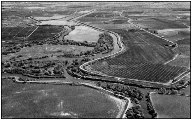
Figure 2.
The majority of Delta islands have been cut off from floods and
tides. A few channel islands continue to be influenced by both.
Before reclamation, three-fifths of the Delta was awash with an ordinary tide, largely submerged by a spring tide and capable of being entirely overflowed by a river flood (Thompson 1957). There was little topographic relief, especially in the central and western Delta. The only features rising above the sea level swamp were the typical asymmetrical natural levees, narrow ridges of alluvium meandering into the backswamps, and occasional wind-deposited hummocks of sand, the highest of these 5 m. (17 ft.) in the western Delta near Knightsen-Oakley. Most features in the central Delta were less than 3 m. (10 ft.) high.
The prereclamation Delta "islands" were thus nothing more or less than backswamps partially or fully enclosed by alluvial levees, drained by meandering sloughs. The natural levees, both parallel and lateral to waterways, were composed of fine to sandy material carried in from surrounding Central Valley uplands by the rivers and their tributaries. The Sacramento River, with its greater volume and velocity, carried greater amounts of sediment toward the Delta than did the San Joaquin, and thus deposited more substantial natural levees.
Levee banks, shaped by tidal scour as much as by river deposition, were abrupt at the river face with the land side sloping inland, enclosing a saucer-like topography. As banks rose high enough above the mean tide level, water-tolerant
vegetation could become established, checking the velocity of sediment-laden water. This would promote the accumulation of greater amounts of alluvium, encouraging more plant growth.
Generally, the height and breadth of natural levees increased with distance north, east, and south from the low tide, low water level at the western apex of the Delta. Thompson (ibid .) reconstructs an approximate gradient of increasing levee height northwest of Sherman Island, north of Isleton, north and east of Staten and Tyler Island, south and east of Roberts and Rough-and-Ready Islands, and southwest of the latitude of Rough-and-Ready Island. These natural levees beyond the central Delta might be as high as 3 to 5 m. (10 to 18 ft.), with the highest approaching 7 m. (24 ft.) at Sacramento. Natural levees averaged as much as 200 m. (660 ft.) wide along the (old) Sacramento River and 120 m. (400 ft.) wide along parts of Steamboat Slough (ibid .).
Prereclamation Riparian Vegetation
Hydric to mesic vegetation reflected the local microtopography of natural levees and hummocks and peripheral gradients in the otherwise unrelieved flat, generally wet terrain. Several investigators have reconstructed historic conditions by studying early illustrations as well as the few remaining sites which are relatively pristine. Thompson describes the conditions that were seen by travelers going up the Sacramento River:
The monotony of the green or brown canebrake-like vegetation was broken by channel and pond surfaces and by strips of alluvial land where woody shrubs and trees and herbaceous annuals grew. This natural levee cover consisted of coarse bunch grasses, willows, blackberry, and wild rose thickets, and galleries of oak, sycamore, alder, walnut, and cottonwood.
The shrubs appeared among the tules of Sherman, Lower Roberts, and other centrally located islands, but a continuity of woody growth probably did not develop until the latitude of Brannan Island and Stockton. This cover became a belt of heavy oak timber on the upper four miles of Union Island, and probably on Robert's Island. Fine groves occupied the more southerly San Joaquin distributary banks. Similar stands of woods occupied the Sacramento River levees upstream from about the lower end of Grand Island, in places so overhanging the river that it interferred with the rigging of passing ships (ibid .).
Levees and Reclamation
Levee building and reclamation of Delta lands irreversibly altered the physical appearance and function of the area. Perhaps nowhere in California have changes to the physiography and hydrography of an area been as profound as those that accompanied reclamation within the Delta. At the same time, throughout the major and minor drainages which feed into the Delta, major land-use changes significantly altered fluvial processes of erosion and deposition, ultimately affecting Delta waterways.
The history and techniques of levee construction in the Delta have been thoroughly documented and need only be reviewed briefly here. The early "shoestring" levees were handbuilt from blocks of sod from island interiors; they were low earthen mounds, resembling natural alluvial levees, and afforded little protection from flooding. Later, clamshell dredges constructed higher, more substantial levees, using construction material from "borrow" ditches immediately external to the levee site. This practice created levees that were set back from an outer, waterside berm. When it was realized that levee survival was partly predicated on the flood-carrying capacity of adjacent channels, the interval between levee toe and borrow ditch was broadened. These residual berms also helped protect levees from rupture and wave attack (ibid .).
To some extent, the berm could accommodate a natural riverine system, the channel and narrow floodplain between levee and berm becoming part of a complementary system in which overland flow could be regarded as a natural process rather than an unnatural hazard. As levee construction techniques improved and conditions of channel alluviation and interior island subsidence dictated, artificial levees became more massive, as much as 61 m. (200 ft.) broad at the base and 9 m. (30 ft.) high, dominating the landscape. Natural levees and most of the artificial berms have either been removed in channel or levee improvements, concealed by reconstruction, or eroded away. The large levee structures which replaced them are so sloped and elevated above the natural floodplain level that with or without riprap they have lost the appearance of a natural floodplain and "riparian zone," except for obvious proximity to a waterway. Nevertheless, the levees introduced into the Delta many miles of topographic relief.
To the extent that "riparian" is an adjective that defines the topographic zone adjacent to fresh water (Warner 1979), the 1,600+ km. (1,000+ mi.) of man-made levees that now line 1,120 km. (700 mi.) of Delta channels and sloughs are riparian zones and hence existing and candidate substrates for woody riparian vegetation. The actual extent of this linear zone probably exceeds that of the prereclamation natural alluvial levees, particularly in the central Delta, which was largely a tidal marsh with little topographic variation.
"Riparian" as a concept also embraces other attributes—notably available soil moisture (high
groundwater table), even distant from waterways. As reclamation proceeded, the backswamps of the Delta were drained and levees cut off their replenishment by flooding. But the water table has continued to be at or near the surface of the land, which is 3 to 6 m. (10 to 20 ft.) below mean sea level in many areas. These conditions would enable mesic vegetation to invade most of the Delta if the land were not regularly drained, cleared, and cultivated.
Changes to Riparian Vegetation Since Reclamation
It is ironic that humans—having built into the unrelieved flat landscape of the Delta hundreds of miles of "riparian zone" within or above the normal tide and floodplain level, sufficiently elevated to support luxuriant plant growth, and having drained the swamps—have been stripping, burning, plowing, or covering much of it ever since.
Some of the early land developers planted alfalfa or Bermuda grass on the waterside of levees in an attempt to reduce wave damage. Willows were used more commonly because they survived prolonged submersion better than alfalfa. Some reclamation interests thought that the roots of willow and other shrubs would reduce the tendency of peat levees to burst when subjected to prolonged river pressure. Unfortunately, willows tended to choke out the tule, depriving levee faces of the mass of sod and stems which were thought to break the force of wave action.
The protective role of berms left in early levee construction was enhanced by natural invasion of willow, cottonwood, and tule, which formed a living defense against wave attack. The exterior borrow ditches served as alluvium traps and sites for succession from tule marsh to diverse riparian communities. Most of these berms are now gone; those remaining are restricted largely to a few reaches where setback levees have been deliberately reconstructed.
Since reclamation, the areal extent of all types of vegetation in the Delta has been steadily decreasing, becoming limited to narrow waterway margins and the outer edges of some levees, a few overflowed tracts, small unreclaimed islands and undeveloped lands outside levees, trapped sloughs and drainage ditches, some inner levee slopes, and whatever lands in island interiors have been left uncultivated or used as dredge spoil sites.
The Delta still contains remnant stands of riparian forest which, if they survived initial reclamation and subsequent clearing of land, continue to survive in spite of virtual isolation from the fluvial processes which induced and once sustained them (fig. 3). A few significant stands of riparian woodland can be found on the periphery of the Delta; there are examples near Thornton at the confluence of the Cosumnes and Mokelumne Rivers, isolated stands northwest of Stockton, and along the southern reaches of old Sacramento River and the San Joaquin River south of Stockton and Tracy. Other vestiges still exist on wooded islands, on a few remaining unleveed banks, and on occasional broad berms left on the waterside of levees.
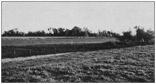
Figure 3.
Most stands of riparian forest have been cleared from the Delta floodplain, leaving stringers
or small islands of cottonwood and associated species in a few uncultivated areas.
Much of the adventitious riparian growth in the Delta still reveals itself as a series of hydric and mesic communities only partially
related to the dynamics of the waterways, dominated by emergent marsh species, with hummocks, older levees, highly modified levees, and miscellaneous interior areas supporting shrub thickets of woody and weedy species. The persistence of certain mesic species in springing up where ever the presence of groundwater, seasonal flooding, and benign neglect permit, is evidence of the natural propensity of the Delta to support riparian plant growth.
"Surrogate" Riparian Communities in the Delta
It is unlikely that levee construction and maintenance, with flood control as its main objective, and the prevailing agricultural land use, which is totally dependent on the levee system, will ever permit further manifestation in the Delta of the rich diversity of species and complex physiognomy that characterize a fully developed riparian plant association. Significant political, economic, technical, legal, and philosophical questions revolve around the maintenance of that system. Two perennial considerations that constrain riparian vegetation in the Delta are: 1) the degree to which vegetation on levees ("riparian" because of the obvious proximity of levees to waterways) is compatible with the primary flood control function and design specifications of the levee system; and 2) the degree to which "natural" vegetation in island interiors ("riparian" because of persistent high groundwater) is compatible with intensive crop cultivation. The levee and other riparian and quasiriparian communities now found in the Delta are often natural in appearance but nonetheless are largely dependent on deliberate or inadvertent human actions.
Levee Riparian Vegetation
The four most common riparian-like communinities associated with waterways on Delta levees are shrub-brush (scrub/shrub in the Sacramento/San Joaquin Environmental Atlas (US Army Corps of Engineers 1979)), brushy riprap (also designated scrub/shrub by the CE), herbaceous banks (labelled upland by the CE (ibid .)), and unvegetated riprap, now a common condition on most maintained and reconstructed levees. Other riparian-like communities found on levees might be called urban (landscaped) riparian; monospecific riparian with such species as willow or alder; and "discontinuous" riparian, evidenced by occasional isolated trees left standing in the wake of stripping, burning, or disking.
Riparian Shrub-Bush .—Riparian shrub-brush is characterized by broad-leaved woody growth less than 6 m. tall. The most common plants are shrubs such as blackberry, wild rose, young alder at the edge of the water, willow species, and herbaceous species such as mugwort and stinging nettle. Occasional small trees—usually willow, cottonwood, or sycamore—may be present. This is a highly variable community; if left undisturbed, as on natural berms on the margin of some of the channel islands, it would develop into woodland. Periodic disturbance from levee maintenance practices generally discourages this long-term successional process, however.
One of two structural components typical of fully developed riparian vegetation may be absent. An upper stratum such as that provided by mature cottonwoods with snags is most often absent. There may or may not be a well-developed thicket and ground stratum, depending on how negligent levee inspection and maintenance have been.
Diversity of bird use of this habitat parallels its relatively lesser vegetative diversity and structural complexity. For example, hawks (e.g., Red-tailed, Red-shouldered, and Swainson's), woodpeckers (Downy and Nuttall's), and certain warblers are heavy users of wooded riparian areas and are largely eliminated from this community by the absence of an upper tree stratum. On the other hand, there is still sufficient vegetative diversity and cover to provide useful habitat for many common species of birds and mammals.
Other variables besides species composition influence wildlife use of this community; continuity (the linear distribution) is often interrupted at property lines or by periodic or partial maintenance; adjacent habitats (agricultural, urban, aquatic) in part determine the distribution of species in and extent of their dependence on this modified riparian vegetation-type.
Brushy Riprap .—Brushy riprap, one of the more common conditions on Delta levees, is valuable as wildlife habitat where riprapped banks have not been disturbed by inspection or maintenance for several years, or where riprapping has been limited to lower portions of the levee, allowing natural vegetation to remain on the upper levee. Vegetation here is less varied than in scrub-brush. Common wild blackberries predominate; other species include occasional shrubby alders at about mean water line, stinging nettles, wild radish, willows, and smartweed. Only when the vegetative cover on riprapped banks has grown almost out of the brush stage does the habitat appear to support wildlife comparable to shrub-brush banks.
Riprap which is exposed at low tides precludes bank burrowing by beavers, muskrats, and kingfishers. Hawks, woodpeckers, most warblers, and flycatchers are eliminated from this kind of substrate; ground foragers and swallows predominate. The yellow-throat, common on Delta freshwater marshes, uses the blackberry jungles of this community. Unvegetated, exposed riprap banks actually enhance striped and black bass habitat by providing substrate for crayfish, an important food source for bass.
Herbaceous Banks .—Herbaceous banks are most common on riprap or on banks where regular maintenance precludes all but summer annuals such
as reed grass and giant reed (at the waterline), scouring rush, blackberry, and wild oats, brome, other introduced grasses, and a variable cover of thistles, poison hemlock, with occasional willow saplings. During the fall and winter, when cover is at a minimum, wildlife use is limited. Summer growth encourages use of the habitat by small seed-eating birds. The only bird species whose presence would qualify this as distinctively "riparian" are the Belted Kingfisher, which perches on small structures associated with the grassy banks, and the swallows flying low overhead. The most conspicuous inhabitant of herbaceous banks in spring and summer months is the ground squirrel, whose potentially destructive burrow colonies are actually favored by cutting and burning of vegetation to facilitate visual inspection of levees (John Muir Institute 1978 a,b).
Unvegetated Riprap .—Unvegetated riprap is similar to herbaceous banks in its absence of vegetative cover. At most, the habitat offers perches and resting areas for birds using the open water and nearby brushy areas.
Neither unvegetated riprap nor herbaceous banks can really be considered "riparian" except according to a broad topographic definition of the term. Yet the majority of levees lining Delta waterways are being managed to achieve this result (fig. 4). A variety of intermediate conditions exist throughout the Delta: old riprapped banks on which willow has formed a discontinuous cover; partially neglected levee faces on which alder saplings have sprung up at the waterline; miles of giant reed lining the water's edge on grass-covered levee banks; occasional trees left to stand alone because the surrounding bare levee slopes permit visual inspection of otherwise pernicious root systems; landscaped residential and recreational frontages, notably deficient (for habitat purposes) in ground or brush stratum or liana. Each of these provides a limited habitat resource, always enhanced by the proximity of water and offering in return at least a narrow, if discontinuous, margin of vegetation or substrate to complement the aquatic environment.
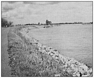
Figure 4.
The safest levee from the perspective of flood control managers
is free of vegetation and open to visual inspection. Habitat
resources are virtually eliminated.
Interior Riparian Vegetation
The most extensive remnants of native riparian woodland occur around the outer margins of the Delta, along those portions of natural floodplains which were either not leveed or not cleared for agricultural cultivation. In a few locations, woodlands extend well back from the rivers along with the alluvial soils on which they grow. Where alluvial soils still exist as narrow levees or margins bordering peat lands in the central Delta, riparian woodlands are minimal and display less deversity of species and structure. Small riparian woodlands occur in the interiors of small islands or on island tips which were all or partially leveed during dredging operations but never cultivated.
The Sacramento/San Joaquin Delta Wildlife Habitat Protection and Restoration Plan (California Department of Fish and Game 1980) did not limit its survey to more obvious manifestations of riparian vegetation on levees along waterways and on the periphery of the Delta. Even highly modified island interiors can reveal wildlife habitats with riparian characteristics. These include seasonally fallow or ruderal lands, dredge disposal areas, drainages and irrigation ditches, and seasonally or periodically flooded agricultural lands.
Ruderal Lands .—Ruderal lands are not widespread in the Delta, where most available land is cultivated. However, a few long-untended fields, abandoned homesites, and agricultural lands damaged by sandy sediments of past floods (e.g., a portion of Brannan Island following the 1972 flood) have been allowed to revert to an almost natural state and are characteristically early successional communities. Species such as sandbar willow, Goodding's willow, and arroyo willow and thick tangles of blackberry are evidence of sufficient year-round soil moisture to eventually support a more diverse riparian-like community behind the levees. Even narrow brushy margins between cultivated fields become important wildlife corridors or islands in the predominantly cultivated landscape.
Unfortunately, ruderal lands in the Delta are totally dependent on individual farming practices. These areas must presently be regarded as transitory, subject to burning, plowing, crop changes, and "clean" farming. They are heavily used by mammalian predators and raptorial birds such as White-tailed Kites and Short-eared Owls because they support large populations of prey species—rodents, reptiles, and ground birds.
Dredge disposal sites .—In the Delta these areas resemble ruderal lands in that they support early successional communities and are highly variable, depending on the underlying residual vegetation, depth of spoils, elevation, and recency and frequency of deposition. Vegetation varies particularly with the age of the spoils; it is not uncommon to find older areas supporting young willows and cottonwoods, as well as herbaceous and other woody species. As with ruderal lands, year-round soil moisture is probably sufficient to eventually sustain larger riparian species if disturbances were discontinued (fig. 5).
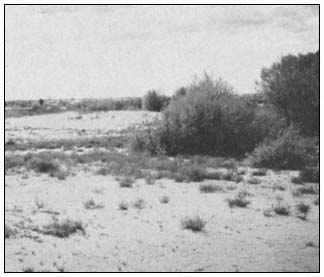
Figure 5.
Dredge material disposal sites in the Delta have
demonstrated the ability to support adventitious
riparian species, such as willow and cottonwood.
Drainage and irrigation ditches .—Drainage and irrigation ditches border and criss-cross agricultural fields and levees throughout the Delta. A few major ditches, such as the one which parallels 8-Mile Road northeast of Stockton, have well-established woody species such as willows and cottonwoods along their banks; others are little more than strips of tules and cattails with brushy margins. While these might be considered minimally "riparian", they are so numerous and widespread that they contribute a significant amount of aquatic and bankside wildlife habitat to the Delta, especially for common birds and amphibians.
The most useful agricultural wildlife habitats in the Delta, and the most "riparian-like", are fields of corn and grain stubble, flooded for several months during the winter for leaching or to create waterfowl habitat. These fields support far greater numbers of individuals (although fewer species) than do more typical riparian areas in the Delta, and closely resemble or at least substitute for ancestral wetland which, prior to reclamation, supported many thousands of the waterfowl wintering in the Delta and elsewhere in the Central Valley. Whistling Swan, Canada Goose, and Sandhill Crane in particular are dependent upon partially flooded fields for winter feeding and resting habitat.
Some fields are flooded briefly in late summer and early fall to control weeds and centipedes. These fields also provide temporary habitat for migrating geese, swans, ducks, and shorebirds. The number, area, and location of flooded fields in the Delta vary considerably from year to year, depending on weather and current leaching practices.
Constraints and Opportunities for Surrogate Riparian Vegetation in the Delta
Constraining Factors
The numerous technical and economic factors responsible for restricting vegetation on Delta levees have been the subject of study and debate for more than two decades and are discussed in many other reports (e.g., California Department of Fish and Game 1980; Whitlow etal . 1979). Briefly, uncontrolled vegetation on levees presents a potential hazard to levee stability. Trees with laterally spreading root systems, such as some willow species, provide paths for piping of water. On the other hand, trees with shallow root systems, such as alder, are subject to wind throw, taking large chunks of the levees with them when they fall. Dense foliage or undergrowth obscures the levee face from easy visual inspection, impedes emergency operations, and, in the opinion of some, attracts burrowing animals.
Opinions vary concerning the contribution of vegetation to erosion control below the high water line: tules, for example, provide a natural breakwater in some situations but cause erosive eddy currents in others. There is general agreement that rock revetment (riprap) is the most reliable means of stabilizing eroding or incompetent banks. However, there is disagreement on the required height of riprap, that is, whether it should be placed below the mean water line, up to the mean water line, or up to the flood stage. The height of the riprap is critical to the amount of vegetation that can be supported on the waterface of the levee.
Riprap is an expensive treatment; its absence on older substandard levees which support some vegetation is often an indication not of preference for vegetation but of lack of sufficient funds or neglect. In all cases, economics are a major determinant in levee construction and maintenance methods. Riparian vegetation is viewed as a costly indulgence both to introduce following construction and to manage as part of ongoing levee maintenance, especially in a region in which agriculture is central to the economy and is dependent on a largely private levee system to separate land from water.
Opportunities
We have applied the term "surrogate" in this discussion to distinguish native riparian vegetation from variant forms of riparian vegetation and wildlife habitat that occur in the Delta. The term also reinforces the notion that protection of existing stands of riparian vegetation and reintroduction of riparian-like vegetation on or off levees under the evident constraints will involve some sacrifices and compromises.
At the outset, protection of existing riparian vegetation will require specific preservation programs that, through acquisition, easement, or other means, assure protection and management in perpetuity. A few of these areas are already publicly owned or have been earmarked for preservation. Certainly, all extant stands of riparian woodland in the Delta have been identified (US Army Corps of Engineers 1979; California Department of Fish and Game 1980). Encouraging expansion of riparian woodland (forest) would require identification of appropriate locations for reintroduction of species and protection through similar preservation programs.
Reintroduction or adoption of more sensitive maintenance practices of riparian-like vegetation will entail either acquisition, easements, subsidies, cost sharing, or a high degree of voluntary cooperation on private levees or in island interiors, to be coupled with one or more of the following management approaches.
Management and "Landscaping" of Permitted or Introduced Vegetation
Bulletin 192 titled "Plan for Improvement of Delta Levees" (California Department of Water Resources 1975) suggests that trees, shrubs, and grasses could be planted on levees between the top of riprap (1.5 ft. (0.5 m.) above mean high water level) and the crown (on a levee with adequate cross-section). Bulletin 192 also recommends that "desirable trees such as oak and crepe myrtle should be retained . . .(that there be) selective clearing of dead, diseased, and unwanted types of vegetatation . . . ." (ibid .). The California Reclamation Board also recommends selecting tree species for maximum height (no more than 40 ft. (12 m.)), deep roots and clean trunks, deciduous foliage; placement of trees above the design floodplain, spacing (8 m. on centers), and limiting numbers (California State Reclamation Board 1976).
These recommendations, if followed throughout the Delta, would result in: 1) elimination of important and characteristic riparian vegetation strata, principally groundcover, brush, and liana; and 2) elimination of certain native species whose growth habit or other characteristics are incompatible with levee design specifications, and possible substitution of other non-native species according to specifications.
However, viewed positively, and notwithstanding the costs, a managed levee riparian community is better than none. Careful planning of revegetation projects and selective management can produce open, not brushy, growth; vegetation at the water's edge; topping of trees at maturity and removal of dead material; selection of species for non-pernicious root systems; and selective eradication of weedy or intrusive exotics.
Overconstruction of Levees
Where technically and economically feasible, overconstruction of levees to accommodate root zones of potentially damaging trees or construction of setback levees to recreate floodplains can be an ideal management practice to allow for growth of riparian vegetation. There is no question among engineers that, in the absence of structural armor (revetment), an overconstructed levee with berm is the only condition under which riparian vegetation can be fully tolerated within the floodplain of Delta waterways. There is sufficient evidence in limited situations to demonstrate that riparian vegetation under these circumstances aids in dissipating the energy of floodflows and waves against the main levee. The circumstances also permit a riparian forest that can safely reach the full maturity of an 18-m. (60-ft.) or higher upper canopy and favor the dense growth of vines and shrubs that are so important in niche differentiation.
Relocation of Riparian Vegetation
Riparian vegetation may be relocated off levees by creating suitable physiographic and hydrographic conditions not necessarily associated with the levees, at least not on their waterside. Many opportunities exist for permitting and encouraging riparian-like vegetation in the Delta so as not to compromise levee stability: on the landface of levees, in untended or uncultivated portions of agricultural lands, along drainage ditches, and on dredge material deposits. Vegetation even on the landface of levees will require a certain amount of landscaping to exclude "uncontrolled growth" and root systems. Ruderal lands, though limited in extent in the Delta, permit the "uncontrolled growth" that often provides the most diverse habitat niches. Their availability, however, is tenuous, varying from year to year.
Carefully managed dredge materials probably offer one of the best opportunities for partial riparian regrowth, because areas are acquired and deliberately set aside for that purpose. In the past, indiscriminate placement of spoils has eliminated or damaged valuable habitat. With proper location, timing, and management of spoils, new wetlands and riparian conditions can be simulated in island interiors, converting a liability to an asset.
Literature Cited
Atwater, B.F. 1979. Generalized geologic map of the Rio Vista 15-minute triangle, California. USDI Geological Survey Open File Report 79-853, scale 1:62,500.
Atwater, B.F. 1980. Attempts to correlate late Quaternary climatic records between San Francisco Bay, the Sacramento-San Joaquin Delta, and the Mokelumne River, California. PhD. Thesis, University of Delaware. 214 p.
California Department of Fish and Game. 1980. Sacramento/San Joaquin Delta wildlife plan. 290 p. Madrone Associates, Novato, California.
California Department of Water Resources. 1975. Plan for improvement of the Delta levees. Bulletin 192, California Department of Water Resources, Sacramento. 26 p.
California Reclamation Board. 1976. Levee encroachment: guide for vegetation on project levees. California Reclamation Board, Sacramento.
Central Valley Riparian Mapping Project. 1979. Interpretation and mapping systems. Report prepared by the Riparian Mapping Team, Geography Department, California State University, Chico, in cooperation with the Department of Geography, California State University, Fresno. 24 p. California Department of Fish and Game, Sacramento. Unpublished manuscript.
Conard, S.G., R.L. MacDonald, and R.F. Holland. 1977. Riparian vegetation and flora of the Sacramento Valley. p. 47–56. In : A. Sands (ed.). Riparian forests in California: their ecology and conservation. Institute of Ecology Pub. No. 15, University of California, Davis. 122 p.
Cowardin, L.M., V. Carter, F.C. Golet, and E.T. LaRoe. 1979. Classification of wetlands and deepwater habitats of the United States. USDI Fish and Wildlife Service Biological Services Program Report FWS/OBS-79/31. 103 P.
Jepson, W.L. 1893. The riparian botany of the lower Sacramento. Ethyreal (January): 238–246.
John Muir Institute. 1978a. Making the transition to an integrated pest management program for ground squirrels on DWR levees. 125 p. Center for the Integration of Applied Sciences (CIAS), John Muir Institute, Berkeley, California.
John Muir Institute. 1978b. Third written report from the Integrated Pest Management Project of the John Muir Institute to the California Department of Water Resources. 120 p. Center for the Integration of the Applied Sciences (CIAS), John Muir Institute, Berkeley, California.
Mason, H.L. 1957. A flora of the marshes of California. 878 p. University of California Press, Berkeley.
Thompson, J. 1957. The settlement and geography of the Sacramento-San Joaquin Delta, California. PhD. Thesis, Stanford University, Palo Alto, California. 551 p.
US Army Corps of Engineers. 1979. Sacramento-San-Joaquin environmental atlas. 318 p.
Warner, R.E. 1979. California riparian study program: background information and proposed study design. 177 p. California Department of Fish and Game, Sacramento.
Whitlow, T.H., R.W. Harris, and A.T. Leiser. 1979. Use of vegetation to reduce levee erosion in the Sacramento-San Joaquin Delta. Prepared for the California Department of Water Resources, Sacramento, California. Contract No. B52830. 46 p. and appendices.