Geography
Mount Lebanon, in the broader sense of the term, indeed has distinctive topographical features. It rises steeply from a very thin coastal strip, reaches imposing heights within 15–20 miles of the coast, and falls to the plains of Ba'lbak and Biqa' on the east, mostly in precipitous slopes. On the north and south it descends through a series of ridges to merge with the plateaus of 'Akkar, and Jabal 'Amil, respectively. As these features separate Mount Lebanon from the world around it, other features divide it internally. Thanks to heavy winter precipitation and considerable snow melt, Mount Lebanon is exceptionally well watered. Water absorbed by its porous higher limestone strata is forced to the surface near the outcrops of basaltic and sandstone layers at an average altitude of 3,000–4,000 feet in perennial and often copious springs. These springs and the gullies they
form feed a number of streams and rivers that, as they rush toward the sea, cut deep ravines and gorges, dividing the Mountain into sharply separated regional enclaves (see Map 1).[2]
Before the advent of modern technology, this tortuous terrain severely limited travel and transportation both within the Mountain areas and between them and neighboring lowland settlements. Tripoli in the north and Saida (Sidon) in the south were the major towns with which the mountaineers remained in contact. Tripoli was the outlet of an agriculturally rich hinterland of its own, and the major international port in the region until about the mid-sixteenth century. Under Ottoman rule, from 1516 onward, Saida began to outshine Tripoli. Saida became the main port of Damascus, the economic and political capital of southern "Syria."[3] Between the orbits of Tripoli and Saida, the Mountain was further divided into a northern zone, economically and administratively attached to Tripoli, and a southern zone linked to Saida. A little river flowing into the bay of Junia, the Mu'amalatain, marked the formal border between the two zones.[4]
Beirut's central location on the coast placed it in a position to serve the middle parts of the Mountain as a market town where local products and produce were exchanged for commodities brought from distant lands via Saida and Tripoli. Dair al-Qamar, in the heart of the south, played a similar role on a much more modest scale. It served as a relay station for the storage and distribution of commodities coming from and bound for Saida and, to a lesser extent, Beirut and the Biqa' valley. Zahla, overlooking the fertille Biqa' valley on the east and only a short distance from Damascus, was another commercial center of some significance. Indeed, when the traffic between Damascus and the coast began to shift away from the Wadi al-Taim—Saida route to the Zahla-Beirut route in the last quarter of the eighteenth century, Zahla rapidly developed into a sizable town.
Simultaneously, commercial relations acquired a greater importance in the Mountain's economy. Even before these changes, people inhabiting the relatively gentler slopes and piedmonts near Tripoli, Saida, and Beirut (or Kura, Kharrub, and Gharb, to be more specific) evidently marketed some of their produce in these towns. Also, production of raw silk and silk cocoons was a major source of cash for almost all parts of the Mountain. But commerce and cash played only a minor role in the lives of most mountaineers. The dearth of regular market towns attests to this point. Even at the beginning of the nineteenth century, Dair al-Qamar's population was around 4,000, that of Zahla around 1,000, and the population of Beirut, including its suburbs, had hardly yet reached 8,000 and was probably as low as 6,000.[5]
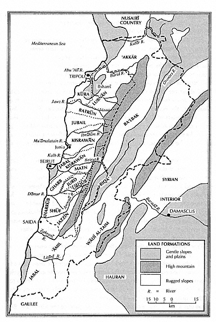
Map 1.
Traditional Districts of Mount Lebanon and Their Relationship to Land
Formations (based on Leon Marfoe, "The Integrative Transformation:
Patterns of Sociopolitical Organization in Southern Syria," Bulletin of the
American Schools of Oriental Research 234 [1979]:26).