1
The Petersburg Tradition
On one side, the sea;
on the other, sorrow;
on the third, moss;
on the fourth, Oh!
—Balakiriev, Court Jester of Peter the Great, early eighteenth century
A Tsar's Vision
St. Petersburg was founded by Peter I the Great in 1703 on the marshy frontier of two competing empires (those of Peter's Russia and the Sweden of Charles XII).[1] The Neva River delta's strategic importance in the imperial competition dictated its fortification despite the area's insalubrious climate and the absence of a commercial base (see Map 3).[2] Millennia before Peter proclaimed the Neva delta to be the site of his imperial capital, the region's 101 islands, 66 rivers, and 100 lakes and ponds lay under 1,000 meters of ice.[3] As the glaciers receded, a flat marshland remained, covered with scant vegetation and subject to frequent flooding.[4] In such an area, the construction even of a village, let alone a world-class metropolis, demanded the kind of perseverance and obstinacy that could be assured only by unrestrained greed for gain or by the iron-willed determination of an autocrat. In either case, the resulting settlement could never emerge as a "natural" extension of its environment. Peter's city—or any other community imposed upon this bleak landscape—would have to be an artifact of human willpower.
The city is situated on the 40-odd islands in the Neva River delta at the eastern end of the Gulf of Finland, surrounded by 50 rivers, streams, channels, and canals. The Neva's main streams divide the city into three general sectors: the right bank to the north and east, the left bank to the south and west, and the marshy islands in between. Nearly all the city's nineteenth-century core is under water once the river rises to four meters above flood stage.
As the present-day city approaches the end of its third century,
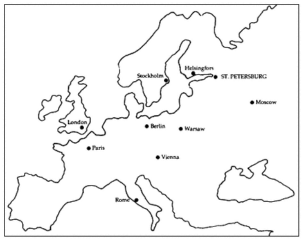
Map 3.
St. Petersburg in relation to other European capitals.
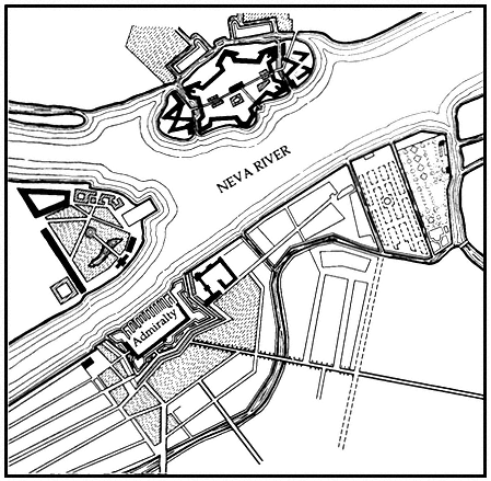
the continuing influence of Peter's original autocratic vision remains undeniable. Efforts to regulate contemporary Leningrad's urban environment must still deal with the imperial capital that Peter and his successors built along the Neva's now granite-lined embankments (see Figures 1 and 2). Before Peter's arrival, the delta's fate seemed to depend primarily on the fortunes of kings and princes hundreds of miles removed. Only some eight years later, in 1711, Peter proclaimed this precarious fortress-settlement as the site of his imperial court. He immediately commanded Russian noblemen and diplomatic emissaries to take up residence in his new capital, while importing conscripted serf labor and foreign artisans to reproduce Amsterdam on the Gulf of Finland. By the time Peter died in 1725, 40,000 souls had come to dwell in his new town (See Table 1 and Map 4).
For nearly 200 years following Peter's death, architects and planners consciously laid out the city as a symbol of the Romanov dynasty and its majesty, suitably encasing in stone the ostentation of Peter and his successors.[5] As a result of this imperial vision, Leningrad remains today anything but a typical Soviet city. The product of human planning and resolution, the city is living evidence of both the best and the worst of nearly three centuries of urban planning. As a "planned city" its successes and failures are shared with cities as diverse as Washington,
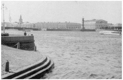
Figure 1.
View of the banks of the Neva River from the Palace embankment.
New Delhi, and Canberra, but not with Moscow, Tbilisi, and Kazan'. Moreover, as the former capital of an empire, it has been demoted to become a still-important but nonetheless provincial center. This experience it shares with Vienna, Istanbul, Rio de Janeiro, and Karachi, but not with Dnepropetrovsk, Novosibirsk, Sverdlovsk, and Vladivostok. Finally, as we have noted, the city's imperial architectural and planning legacies provide contemporary city planners and architects with a unified urban vision. The city's historic reliance on sweeping urban vistas and grand harmonious spaces filled with dynamic plastic facades continues to influence present-day efforts to regulate the urban environment.[6] To understand its role, we must return to Peter's original vision for his new capital city.
The Romanov Imperial Legacy
Peter conceived a well-ordered and regular brick town, similar to the Dutch cities he had seen during his famous excursion through Western Europe. He hoped that his little Dutch town would contrast sharply with the chaos of traditional Russian cities such as his native capital of Moscow.[7] His efforts focused initially on Vasil'evskii Island, where Peter, his governor Prince Menshikov, and his architect, Frenchman Jean-Baptiste Alexandre Le Blond, decided to locate the town's center
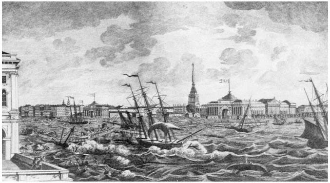
Figure 2.
The painting, executed in 1824, depicts the difficulties posed by the frequent floods of the Neva River for the city of Leningrad.
| |||||||||||||||||||||||||||||||||||||||||||||||||||||||||||||||||||||||||||||||||
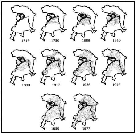
Map 4.
Settled areas of the city of Leningrad, 1717–1977.
(see Figure 3).[8] Le Blond's 1717 plan, the first of many citywide planning efforts, called for an overtly geometric configuration on Vasil'evskii Island, reminiscent of Amsterdam, with streets and canals intersecting at right angles, thereby dividing the city into strictly organized functional zones. These early plans were doomed to failure, however, by strains on the state budget caused by Peter's constant warring, together with the hazards of travel from the mainland across treacherous currents and the constant threat of severe flooding.[9]
Peter's city never truly conformed to the Dutch building practices of the day. Town planning concepts in Holland had begun to develop during the Middle Ages, and by the seventeenth and eighteenth centuries the Dutch were acknowledged leaders in the field.[10] For the Dutch, the concept of "town" had a very precise meaning. It always contained a market, was surrounded by a wall, and had been granted a charter. In short, the Dutch town remained a mercantile invention
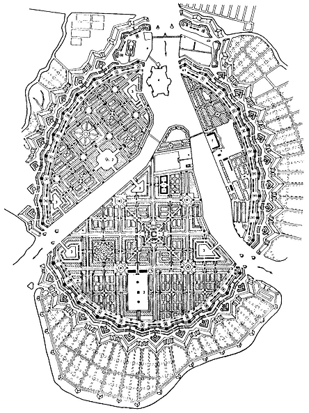
Figure 3.
Le Blond's 1717 plan.
developed over the years to meet the needs of multiple users. In contrast, St. Petersburg had only one prime user—the tsar, the Romanov autocrat—who wanted the capital to embody dynastic grandeur.
Peter visited Amsterdam a half-century after the Dutch had gained their independence from Spain in 1648. There he saw a boomtown that had developed according to one of the most comprehensive and ambitious town plans in all of Europe—the Amsterdam plan of 1607. By the time of Peter's visit, the plan, characterized by strict building codes and functional zoning, had created an orderly and compact city. Peter was also undoubtedly aware of the Copenhagen city plan, drafted by Dutch architects and implemented between 1588 and 1648.[11] Thus we should hardly be surprised that he would have desired to copy the bourgeois Dutch. Had he succeeded in the face of the Russian autocratic tradition, however, it would have been a miracle. True, the Saint-Iler plan of St. Petersburg developed in 1764–1773 at Catherine II's behest portrays in almost photographic detail networks of facades conforming to a uniform street line as in Dutch practice. In this sense, Dutch influence remained evident in the city's physical development well into the eighteenth century. Yet, just behind these formal facades vast open spaces and eclectic courtyards betray their essentially Russian origins.[12]
Following the reigns of Peter and later his widow, Catherine I (1725–1727), St. Petersburg embarked upon a stormy half-century that witnessed the capital's return to Moscow under Peter's grandson Peter II (1727–1730); its restoration to Petersburg by Peter's niece, Anna (1730–1740); and its embellishment during a brilliant explosion of Russian rococo under Peter I's daughter, Elizabeth (1741–1762) (see Chart 3).[13] The period proved critical for the city's development. The distinctive triradial street system centering on the Admiralty spire emerged during Anna's rule (see Map 5), while Elizabeth launched an impressive network of imperial parks and satellite palaces and towns. More importantly, the city's role as capital was secured as its population grew to 90,000 by the middle of the eighteenth century. By the time Elizabeth's niece by marriage, Catherine II, the Great (1762–1796), seized power in a palace coup, the city had developed a distinctive urban culture. Although this culture remained essentially Russian, it had become permeated with European ideas.[14]
In the reigns of Catherine II and her grandsons Alexander I (1801–1825) and Nicholas I (1825–1855), St. Petersburg grew into a great European capital. The city's center emerged as one of the world's leading ensembles of neoclassical architecture,[15] and the population more than quadrupled as migrants began to arrive from the countryside. Urban growth abated only slightly, after a mid-century cholera epidemic.
Catherine II and her progeny saw themselves as rulers of a major European power, and to express their new pretensions, they turned to
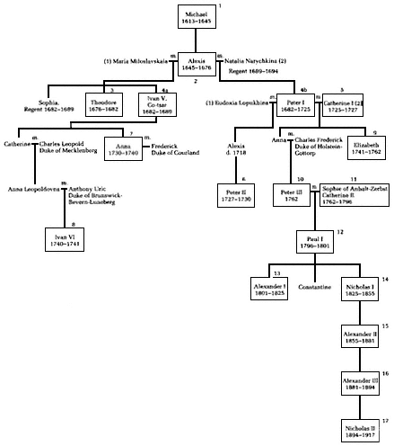
Chart 3.
The Romanov dynasty.
a neoclassicism then popular in France. The result was nearly a century of neoclassical construction as extensive as any similar project elsewhere in the world (see Figures 4 and 5). What is known today as Leningrad—and what Soviet architects of the 1930s sought to reproduce on an even grander scale—is the neoclassical city of Catherine the Great and her grandsons. It is the model against which all subsequent planning and design efforts for the city have been and continue to be judged.
The Catherinian achievement paved the way for the apex of Russian neoclassical architecture and urban design under Alexander I.[16] During Catherine's rule, as comprehensive planning efforts were under-
Map 5.
St. Petersburg at the end of the reign of Elizabeth. Outline highlights
the triradial street system focusing on the Admiralty spire.
taken, new spatial concepts for the architectural organization of the city had come to the fore. Town builders spared no effort to make their capital more magnificent and beautiful. Moreover, they believed that nothing served their purpose better than to fill the city's central core with significant buildings and regular squares (see Figure 6). Each building retained its individuality, while also being integrated into the entire urban ensemble. Large-scale building efforts were not always practical, so that only a limited number of monumental structures could be built. Consequently, for maximum effect vigorous buildings were to be placed at critical junctions, with secondary spaces left for later generations to deal with.
The immediate task of finishing Catherine's classical masterpiece
Figure 4.
The Senate/Synod building—an example of neoclassical architecture.
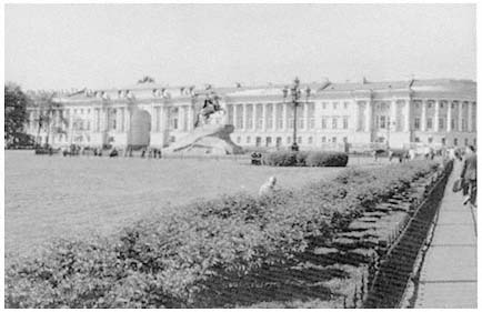
Figure 5.
The Senate/Synod building overlooking Senate Square.
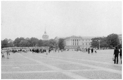
Figure 6.
The Admiralty from Palace Square.
fell to her son Paul I (1796–1801) and her grandsons Alexander I and Nicholas I. Under the autocracy, the selection of a chief architect and a general superintendent of government buildings remained the prerogative of the sovereign. It was thus inevitable that the monarch's fancies would influence the course of architectural history. During Paul's brief reign, which ended with his assassination in a palace closet, St. Petersburg assumed a somber military air appropriate for its dour autocrat's temperament. Under Alexander I, by contrast, the autocrat's good taste and clear understanding of what his grandmother had accomplished led to the pinnacle of imperial Russian neoclassicism. Alexander particularly wanted his capital to be the most harmonious and beautiful in Europe, and acted to ensure that it would become so. The near-realization of his goal has left an indelible mark on Leningrad to this day.[17] The construction of several central squares surrounding the Admiralty district and the beautification of Nevskii Prospekt mark the culmination of planning efforts of the Alexandrian epoch (see Map 6). A century and a half later, these achievements still influence the work of Leningrad city planners and architects (see Figures 7 and 8).
The completion of the city's central squares containing nearly 100 acres of open space, together with the establishment of Nevskii Prospekt as the city's central axis (see Figure 9), created an urban system that Soviet architects sought at first to surpass, but more recently to preserve.[18] Under Alexander I and Nicholas I, St. Petersburg was transformed into a grand spatial composition of seemingly unbroken chains

Map 6.
St. Petersburg's central squares.
of related ensembles. Present-day Leningrad architects have come to regard this "Petersburg tradition" as demanding a large expanse of unbroken facade. This legacy is now venerated, although during its own century it proved to be rather short-lived, as social forces unleashed by the industrial revolution swept away the order and predictability of the capital of Alexander I and Nicholas I.
Cradle to Revolution
The omnipresent order that the city had at the beginning of the nineteenth century faded under the press of industrialization. By the beginning of the twentieth century, St. Petersburg had become the most expensive and least healthful capital in all of Europe.[19] With a high
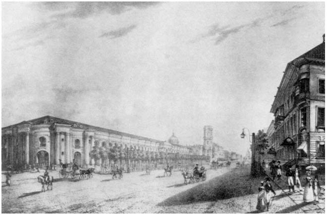
Figure 7.
Painting of Nevskii Prospekt.
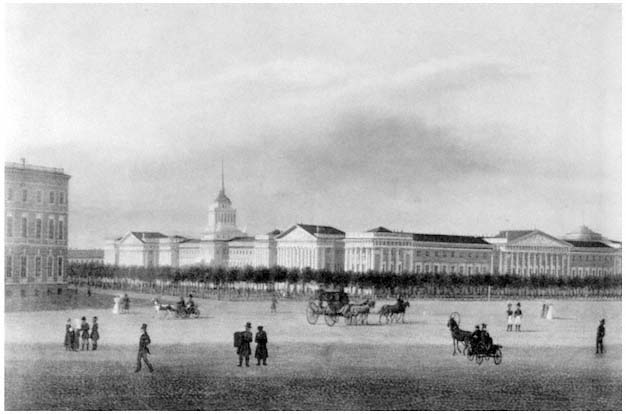
Figure 8.
Painting of corner near the Winter Palace.
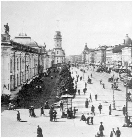
Figure 9.
Photo of Nevskii Prospekt at the turn of the century.
mortality rate even by urban Russian standards, the capital experienced fierce outbreaks of infectious diseases attributable in part to geography and climate and in part to municipal ineptitude. In addition, the city suffered from chronic epidemics of venereal disease, a high incidence of drunkenness, a soaring crime rate, abysmal housing conditions, and high levels of illiteracy.[20] St. Petersburg apartments housed twice as many people as apartments in the already overcrowded European capitals Berlin, Vienna, and Paris.[21]
Between 1870 and 1914, a million and a half new residents moved to the city; of these, a million came after 1890 and 350,000 arrived in the boom years of 1908 to 1913.[22] By 1914, when it was renamed Pet-rograd, the Russian capital was Europe's fifth largest city, surpassed only by London, Paris, Vienna, and Berlin. Its population and employment were dominated by businessmen and workers. Many of the latter,
however, had arrived fresh off the farm, as the city experienced its first major wave of migration from the countryside. The pressures of industrialization soon coincided with a rapidly escalating population, overwhelming municipal administrators. Housing and zoning codes were largely ignored, municipal services were far outstripped by demand, and the city's severe climatic conditions made a bad situation worse.[23]
The causes of the municipal administration's near-total collapse in the final quarter of the nineteenth century were cultural, structural, and financial. Russian society remained essentially preurban in outlook.[24] Prince and peasant alike regarded their residence in the capital as only transitory. For the nobility, St. Petersburg was the place to go for the winter social season. For the peasant, it was a place to earn money for the family back home. By harvest time many workers simply returned to the fields.[25] This generally low level of commitment to the city, combined with an autocratic administrative system, forced municipal officials to become more closely tied to the needs of the monarch than to those of the ostensibly passive populace. The city's largely underdeveloped municipal institutions retained essentially a static view of their role in a rapidly changing society.
One major reason for the municipality's apparent inaction remained financial. The city's operating budget was modest by European and even by Russian standards. City funds were derived largely from profits generated by such municipal concessions as the tram system, the water system, the gasworks, and a municipal slaughterhouse.[26] Under constant inflationary pressure, the city government eventually was forced to seek additional funds from the bond markets of London and Paris. The charges for servicing the municipal debt, while small by the practice of the period, nonetheless tripled between 1901 and 1910, reaching 2.9 million rubles annually.[27] In the end, the underdeveloped and underfinanced municipal structure was totally incapable of coping with the changes brought about by the industrial revolution.
Many in the city deplored the transformation of their capital from the relative order during the reign of Nicholas I to the growing chaos during that of Nicholas II. As industrialization swept across the Russian empire, antithetical nationalist and internationalist currents were felt throughout the capital's intellectual and cultural elites. In architecture, the nationalist movement shared broad concerns with the emergence throughout Europe of a romantic interest in the past.[28] As in Western Europe, this process of discovery took place in reverse chronological order, leading to an extensive eclecticism in design, which in St. Petersburg clashed with the city's predominantly classical spirit. Prime examples of this genre can be seen in the more "Russian" Moscow. In Petersburg, the Church of the Savior on the Blood, erected on the site of Alexander II's assassination, is the best local example of this drive
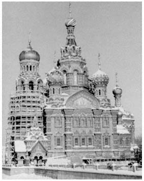
Figure 10.
Church of the Savior of the Blood.
to re-create a mythical national Russian architectural form (see Figure 10).[29]
Against this national romantic revival were posed the overtly internationalist predilections of those associated with the journal Mir iskusstva , which appeared from 1898 until 1904, as well as its successors Starye gody (1907–1916), Zolotoe runo (1906–1909), and Appolon (1909–1917). These journals represented the major Russian components of the international symbolist movement of the 1890s and early 1900s. Such groups were concentrated in the more Western-oriented capital, and were primarily attracted to the city's past, with the neo-classicism of Catherine II and Alexander I holding particular fascination for them. This movement's image was reflected in the works of the brothers Benois (Leontii and Alexander) as well as in Ivan Fomin's massive proposal for a "New Petersburg" project on Golodai (later De-cembrist) Island, a design every bit as classical in style and grand in execution as the original city (see Figure 11).[30]
These prerevolutionary reactions to the disintegration of the urban fabric caused by industrialization constitute the final imperial legacy for later generations of planners and architects in the Soviet period.
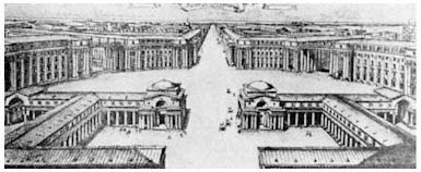
Figure 11.
Example of the "New Petersburg" project.
Their architectural strategies—which dismissed private property, demanded large-scale state intervention, and produced a style characterized by grandeur and unity—offered an urban vision that awaited an audience.[31] That audience was found by the end of the 1920s, as a new Stalinist cult of the state began to emerge, one that was receptive to fundamental characteristics of the Petrine-Catherinian-Alexandrine tradition of St. Petersburg as translated by the Mir iskusstva movement of the 1890s and early 1900s.
In the interim, the Bolshevik seizure of power on November 7 (October 24, Old Style), 1917 had unleashed a bloody civil war. By March 1918, Lenin was forced to transfer his government to the protective sanctuary of Moscow's Kremlin. With the seat of government removed to rival Moscow and with food supplies disrupted by fighting in the countryside, Petrograd residents fled their city. The gentry and merchant classes largely sought refuge abroad, while workers in many instances returned to their native villages or joined the Red Army. The city's population plummeted from a prewar high of 2,300,000 to a civil war low of only 720,000.
Once the new government had consolidated power and launched its New Economic Policy (NEP), designed to encourage small businesses, Petrograd—renamed Leningrad after Lenin's death in 1924—began to regain population. Still, with urban unemployment rates continuing high and trade flourishing in the countryside throughout the 1920s, its population remained well below pre-World War I levels. The launching of Stalin's collectivization and industrialization drive in 1928 unleashed yet another torrent of peasants fleeing the countryside. Every Soviet city expanded at unprecedented rates. The influx into Leningrad increased the local population by over 1.3 million between 1929 and the prewar census of 1939, which tallied a record population
of 3,119,000, with an additional 300,000 residing in the surrounding urban areas. This population increase combined with a revival of interest in grandiose neoclassicism to produce a distinctively Stalinist Leningrad.
Stalin's Soviet Legacy
The collapse of the Romanov dynasty touched off a vigorous anti-urban revolt among many intellectuals, particularly in the small community of professional urbanists and architects. At least among professional circles, this revulsion against the urban environment was centered in Moscow, where living conditions were every bit as pestilential as in Petrograd,[32] but where the city's physical unruliness offered none of the psychic relief provided by the lingering orderly aesthetic impact of the still-visible Alexandrine physical plant in Petrograd. In Petrograd, revulsion against the city's abysmal living conditions took a slightly different turn.[33]
As in Moscow, local Petrograd officials moved immediately to clean up particularly noxious neighborhoods.[34] Nevertheless, the local architectural community's image of the city remained essentially the original Romanov vision as transmitted through the prism of the "New Urbanism" of the city's turn-of-the-century artistic intelligentsia. The continued nurturing of this tradition by Leningrad architects throughout the 1920s psychologically prepared that community for Lazar Kaganovich's 1931 declaration that the Soviet Union's industrial future would be urban by definition.[35]
Immediately after Kaganovich's 1931 address, central elites instructed the city governments and Communist Party organizations in Moscow and Leningrad to prepare comprehensive physical development plans for their cities. In 1935 the Central Committee of the All-Union Communist Party (Bolshevik) and the USSR Council of People's Commissars joined with Moscow municipal institutions to promulgate a comprehensive plan for the reconstruction of Moscow.[36] The following year the same central institutions joined with the Leningrad city soviet to enact an equally far-reaching general development plan for the old imperial northern capital.[37]
According to the 1936 Leningrad general plan drawn up under the direction of Lev Il'in and Vladimir Vitman, the city would abandon its historic center focused on the Admiralty and Neva for a new and grander city center along an expansive boulevard (International [now Moskovskii] Prospekt) running directly south from the Peace Square for some ten kilometers (see Map 7).[38] This new city center, which together with the buildings of the 1920s has recently become a hub of historic preservation efforts,[39] was unified through a common focus on
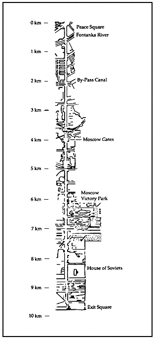
Map 7.
International/Moscow Prospekt project.
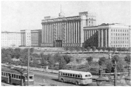
Figure 12.
House of Soviets building.
a gargantuan House of Soviets building placed strategically along the new thoroughfare.[40] That whole complex, when constructed, covered a total of 13 acres, nine of which were deemed to be usable building space.[41] Heavy and neoclassical, this ponderous building overwhelmed the as-yet vacant surrounding territory. The House of Soviets, and the 1936 general plan that produced it, captured not only the ethos of Stalinist statism but also that of the "New Petersburg" movement of three decades earlier (see Figure 12). This project represented the logical culmination of an imperial Petersburg tradition that sought to symbolize the pomposity of state authority in stone. Its neoclassical inspiration similarly testifies that the arrogant assertion of human order over nature, visible in the classicism of the Renaissance, continued to inspire imperial Russian and Soviet architects centuries later.
In his memoirs, Nikolai Baranov attests to the direct influence of Renaissance design principles and philosophy on his generation of Leningrad architects as they set to work during the Stalinist period.[42] Baranov, who was the city's chief architect from 1938 until 1950 and was one of the most influential Soviet city planners of his era,[43] reports that Lev Il'in, his predecessor as chief architect from 1925 until 1938, served as a primary mentor to the city's numerous young architects throughout the twenties and thirties (Il'in was later killed during a German bombardment of the city in December 1942).[44] Il'in, it turns out, collected eighteenth- and nineteenth-century furniture, paintings, carpets, china, and crystal.[45] He also compiled a 5,000-volume library of rare archi-
tectural works focusing primarily on the period of the Italian Renaissance, including works by Palladio, Alberti, and Piranesi.[46]
Il'in's chosen visual environment was that of Renaissance classicism and Russian neoclassicism. Through his thoughtful supervision of their work, he transmitted his aesthetic preferences to a generation of apprentice architects. Similarly, his own designs for Leningrad, as well as for Baku, where he also served as chief architect throughout most of the 1930s, displayed an intense interest in neoclassical principles.[47] Confronted with the strong neoclassical tradition of Leningrad and of its professional architectural elite, the new-found statism of the Stalinist regime saw in Peter's former capital a ready outlet for its pretensions.
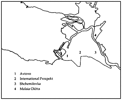
Soon, however, Leningrad city administrators came to view the initial 1936 general plan as impractical. In 1938, a team of architects under Baranov and Aleksandr Naumov revised the original plan, seeking a more effective use of the available land.[48] As part of this revision, the new city center project was scaled down from 99 acres to 28. Baranov later observed that this reduction brought the planned ensemble into scale with such urban vistas as the Mall in Washington, D.C., and the Champs-Elysées in Paris.[49] The new plan also noted that "serious inconveniences" would result from an immediate abandonment of the historic city center. Nevertheless, the primary thrust of new construction was still concentrated in the same four districts first designed in 1936: Avtovo, Shchemilovka, Malaia Okhta, and the International Prospekt Project (see Map 8).[50] From 1936 until 1941 more than 800,000 square meters of housing space, 213 schools, and 200 preschool facilities were built in the city, mainly in these four areas.[51]
Three overarching considerations explain the plan's preoccupation with moving the city's population southward. First, the new center was designed to overwhelm the historic city core, thereby destroying the political symbolism of the prerevolutionary architectural ensemble by erecting an even grander "socialist" statist environment nearby. Second, by moving the city to higher ground, the planners sought to reduce a tragic pattern of flooding. Third, once the decision was made to abandon the historic city center, movement to the south became inevitable. With the Finnish border only 22 miles to the north, national security interests demanded urban development in the opposite direction. The short but bloody Winter War with the Finns in 1939–1940 demonstrated the military wisdom of such a plan, as Leningrad was quickly transformed into a garrison city. Of the 200,000 Soviet casualties suffered in that war, by far the largest percentage were among Leningraders.[52] This loss was, of course, soon overshadowed by the virtual annihilation that occurred during World War II's blockade.
On the night of June 21–22, 1941, Hitler's Wehrmacht rolled across the Soviet Union's western frontier, and within a few weeks the
Map 8.
Major construction projects during the 1930s.
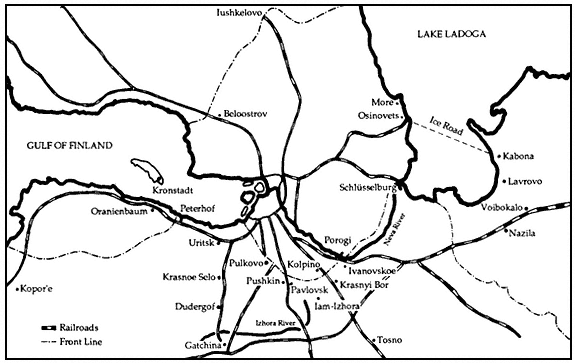
Map 9.
The front line on September 25, 1941.
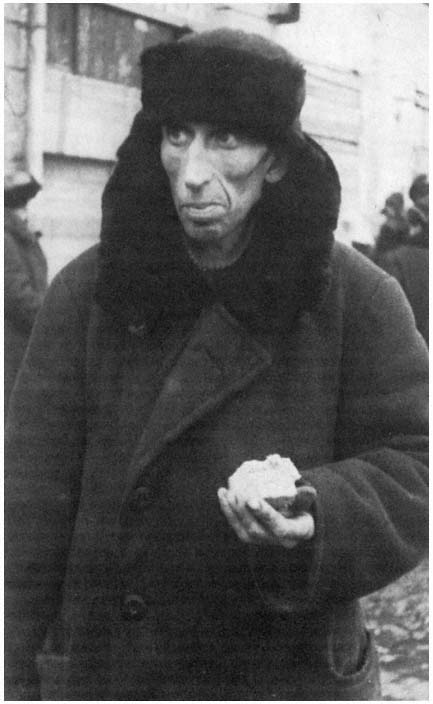
Figure 13.
Photo of effects of the blockade.
country's second largest city was under a siege that was to last two and a half years (see Map 9 and Figure 13).[53] The fate of over 40 percent of the city's prewar population is unknown and cannot be reconstructed from official Soviet statistics.[54] What is known is that, by early 1942, Leningrad's population had been cut by two thirds through war-related casualties, starvation (as many as 30,000 civilians died on each of the worst February days), and evacuation (over a half-million civilians successfully left the city on the 237-mile "Road of Life" across the ice of Lake Ladoga and through surrounding forests to the nearest railhead).[55] To put these figures into comparative perspective, the number of Leningraders who perished during the blockade approximately equals the total number of U.S. armed forces personnel who died in all wars from the American Revolution through the war in Vietnam.[56] By the end of the blockade's second winter, Leningrad had shrunk to only 639,000 residents—less than the city's population at the height of the Civil War—and its industrial base was operating at only 10 percent of its prewar capacity when measured by the value of industrial production.[57]