I
THE PHYSICAL ENVIRONMENT
1
The Petersburg Tradition
On one side, the sea;
on the other, sorrow;
on the third, moss;
on the fourth, Oh!
—Balakiriev, Court Jester of Peter the Great, early eighteenth century
A Tsar's Vision
St. Petersburg was founded by Peter I the Great in 1703 on the marshy frontier of two competing empires (those of Peter's Russia and the Sweden of Charles XII).[1] The Neva River delta's strategic importance in the imperial competition dictated its fortification despite the area's insalubrious climate and the absence of a commercial base (see Map 3).[2] Millennia before Peter proclaimed the Neva delta to be the site of his imperial capital, the region's 101 islands, 66 rivers, and 100 lakes and ponds lay under 1,000 meters of ice.[3] As the glaciers receded, a flat marshland remained, covered with scant vegetation and subject to frequent flooding.[4] In such an area, the construction even of a village, let alone a world-class metropolis, demanded the kind of perseverance and obstinacy that could be assured only by unrestrained greed for gain or by the iron-willed determination of an autocrat. In either case, the resulting settlement could never emerge as a "natural" extension of its environment. Peter's city—or any other community imposed upon this bleak landscape—would have to be an artifact of human willpower.
The city is situated on the 40-odd islands in the Neva River delta at the eastern end of the Gulf of Finland, surrounded by 50 rivers, streams, channels, and canals. The Neva's main streams divide the city into three general sectors: the right bank to the north and east, the left bank to the south and west, and the marshy islands in between. Nearly all the city's nineteenth-century core is under water once the river rises to four meters above flood stage.
As the present-day city approaches the end of its third century,
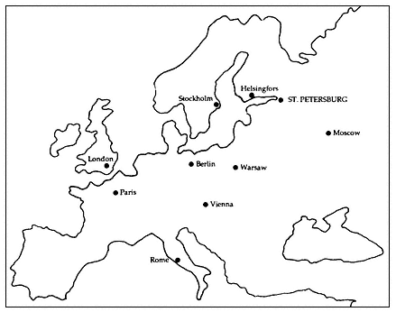
Map 3.
St. Petersburg in relation to other European capitals.
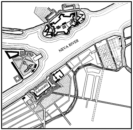
the continuing influence of Peter's original autocratic vision remains undeniable. Efforts to regulate contemporary Leningrad's urban environment must still deal with the imperial capital that Peter and his successors built along the Neva's now granite-lined embankments (see Figures 1 and 2). Before Peter's arrival, the delta's fate seemed to depend primarily on the fortunes of kings and princes hundreds of miles removed. Only some eight years later, in 1711, Peter proclaimed this precarious fortress-settlement as the site of his imperial court. He immediately commanded Russian noblemen and diplomatic emissaries to take up residence in his new capital, while importing conscripted serf labor and foreign artisans to reproduce Amsterdam on the Gulf of Finland. By the time Peter died in 1725, 40,000 souls had come to dwell in his new town (See Table 1 and Map 4).
For nearly 200 years following Peter's death, architects and planners consciously laid out the city as a symbol of the Romanov dynasty and its majesty, suitably encasing in stone the ostentation of Peter and his successors.[5] As a result of this imperial vision, Leningrad remains today anything but a typical Soviet city. The product of human planning and resolution, the city is living evidence of both the best and the worst of nearly three centuries of urban planning. As a "planned city" its successes and failures are shared with cities as diverse as Washington,
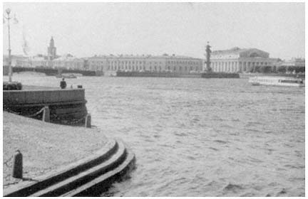
Figure 1.
View of the banks of the Neva River from the Palace embankment.
New Delhi, and Canberra, but not with Moscow, Tbilisi, and Kazan'. Moreover, as the former capital of an empire, it has been demoted to become a still-important but nonetheless provincial center. This experience it shares with Vienna, Istanbul, Rio de Janeiro, and Karachi, but not with Dnepropetrovsk, Novosibirsk, Sverdlovsk, and Vladivostok. Finally, as we have noted, the city's imperial architectural and planning legacies provide contemporary city planners and architects with a unified urban vision. The city's historic reliance on sweeping urban vistas and grand harmonious spaces filled with dynamic plastic facades continues to influence present-day efforts to regulate the urban environment.[6] To understand its role, we must return to Peter's original vision for his new capital city.
The Romanov Imperial Legacy
Peter conceived a well-ordered and regular brick town, similar to the Dutch cities he had seen during his famous excursion through Western Europe. He hoped that his little Dutch town would contrast sharply with the chaos of traditional Russian cities such as his native capital of Moscow.[7] His efforts focused initially on Vasil'evskii Island, where Peter, his governor Prince Menshikov, and his architect, Frenchman Jean-Baptiste Alexandre Le Blond, decided to locate the town's center
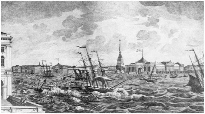
Figure 2.
The painting, executed in 1824, depicts the difficulties posed by the frequent floods of the Neva River for the city of Leningrad.
| |||||||||||||||||||||||||||||||||||||||||||||||||||||||||||||||||||||||||||||||||
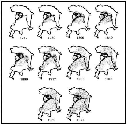
Map 4.
Settled areas of the city of Leningrad, 1717–1977.
(see Figure 3).[8] Le Blond's 1717 plan, the first of many citywide planning efforts, called for an overtly geometric configuration on Vasil'evskii Island, reminiscent of Amsterdam, with streets and canals intersecting at right angles, thereby dividing the city into strictly organized functional zones. These early plans were doomed to failure, however, by strains on the state budget caused by Peter's constant warring, together with the hazards of travel from the mainland across treacherous currents and the constant threat of severe flooding.[9]
Peter's city never truly conformed to the Dutch building practices of the day. Town planning concepts in Holland had begun to develop during the Middle Ages, and by the seventeenth and eighteenth centuries the Dutch were acknowledged leaders in the field.[10] For the Dutch, the concept of "town" had a very precise meaning. It always contained a market, was surrounded by a wall, and had been granted a charter. In short, the Dutch town remained a mercantile invention
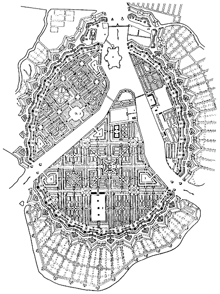
Figure 3.
Le Blond's 1717 plan.
developed over the years to meet the needs of multiple users. In contrast, St. Petersburg had only one prime user—the tsar, the Romanov autocrat—who wanted the capital to embody dynastic grandeur.
Peter visited Amsterdam a half-century after the Dutch had gained their independence from Spain in 1648. There he saw a boomtown that had developed according to one of the most comprehensive and ambitious town plans in all of Europe—the Amsterdam plan of 1607. By the time of Peter's visit, the plan, characterized by strict building codes and functional zoning, had created an orderly and compact city. Peter was also undoubtedly aware of the Copenhagen city plan, drafted by Dutch architects and implemented between 1588 and 1648.[11] Thus we should hardly be surprised that he would have desired to copy the bourgeois Dutch. Had he succeeded in the face of the Russian autocratic tradition, however, it would have been a miracle. True, the Saint-Iler plan of St. Petersburg developed in 1764–1773 at Catherine II's behest portrays in almost photographic detail networks of facades conforming to a uniform street line as in Dutch practice. In this sense, Dutch influence remained evident in the city's physical development well into the eighteenth century. Yet, just behind these formal facades vast open spaces and eclectic courtyards betray their essentially Russian origins.[12]
Following the reigns of Peter and later his widow, Catherine I (1725–1727), St. Petersburg embarked upon a stormy half-century that witnessed the capital's return to Moscow under Peter's grandson Peter II (1727–1730); its restoration to Petersburg by Peter's niece, Anna (1730–1740); and its embellishment during a brilliant explosion of Russian rococo under Peter I's daughter, Elizabeth (1741–1762) (see Chart 3).[13] The period proved critical for the city's development. The distinctive triradial street system centering on the Admiralty spire emerged during Anna's rule (see Map 5), while Elizabeth launched an impressive network of imperial parks and satellite palaces and towns. More importantly, the city's role as capital was secured as its population grew to 90,000 by the middle of the eighteenth century. By the time Elizabeth's niece by marriage, Catherine II, the Great (1762–1796), seized power in a palace coup, the city had developed a distinctive urban culture. Although this culture remained essentially Russian, it had become permeated with European ideas.[14]
In the reigns of Catherine II and her grandsons Alexander I (1801–1825) and Nicholas I (1825–1855), St. Petersburg grew into a great European capital. The city's center emerged as one of the world's leading ensembles of neoclassical architecture,[15] and the population more than quadrupled as migrants began to arrive from the countryside. Urban growth abated only slightly, after a mid-century cholera epidemic.
Catherine II and her progeny saw themselves as rulers of a major European power, and to express their new pretensions, they turned to
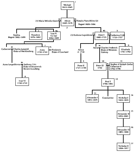
Chart 3.
The Romanov dynasty.
a neoclassicism then popular in France. The result was nearly a century of neoclassical construction as extensive as any similar project elsewhere in the world (see Figures 4 and 5). What is known today as Leningrad—and what Soviet architects of the 1930s sought to reproduce on an even grander scale—is the neoclassical city of Catherine the Great and her grandsons. It is the model against which all subsequent planning and design efforts for the city have been and continue to be judged.
The Catherinian achievement paved the way for the apex of Russian neoclassical architecture and urban design under Alexander I.[16] During Catherine's rule, as comprehensive planning efforts were under-
Map 5.
St. Petersburg at the end of the reign of Elizabeth. Outline highlights
the triradial street system focusing on the Admiralty spire.
taken, new spatial concepts for the architectural organization of the city had come to the fore. Town builders spared no effort to make their capital more magnificent and beautiful. Moreover, they believed that nothing served their purpose better than to fill the city's central core with significant buildings and regular squares (see Figure 6). Each building retained its individuality, while also being integrated into the entire urban ensemble. Large-scale building efforts were not always practical, so that only a limited number of monumental structures could be built. Consequently, for maximum effect vigorous buildings were to be placed at critical junctions, with secondary spaces left for later generations to deal with.
The immediate task of finishing Catherine's classical masterpiece
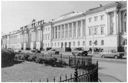
Figure 4.
The Senate/Synod building—an example of neoclassical architecture.
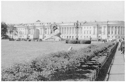
Figure 5.
The Senate/Synod building overlooking Senate Square.
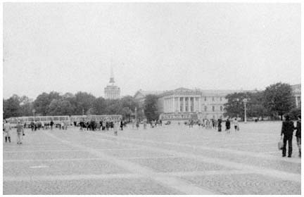
Figure 6.
The Admiralty from Palace Square.
fell to her son Paul I (1796–1801) and her grandsons Alexander I and Nicholas I. Under the autocracy, the selection of a chief architect and a general superintendent of government buildings remained the prerogative of the sovereign. It was thus inevitable that the monarch's fancies would influence the course of architectural history. During Paul's brief reign, which ended with his assassination in a palace closet, St. Petersburg assumed a somber military air appropriate for its dour autocrat's temperament. Under Alexander I, by contrast, the autocrat's good taste and clear understanding of what his grandmother had accomplished led to the pinnacle of imperial Russian neoclassicism. Alexander particularly wanted his capital to be the most harmonious and beautiful in Europe, and acted to ensure that it would become so. The near-realization of his goal has left an indelible mark on Leningrad to this day.[17] The construction of several central squares surrounding the Admiralty district and the beautification of Nevskii Prospekt mark the culmination of planning efforts of the Alexandrian epoch (see Map 6). A century and a half later, these achievements still influence the work of Leningrad city planners and architects (see Figures 7 and 8).
The completion of the city's central squares containing nearly 100 acres of open space, together with the establishment of Nevskii Prospekt as the city's central axis (see Figure 9), created an urban system that Soviet architects sought at first to surpass, but more recently to preserve.[18] Under Alexander I and Nicholas I, St. Petersburg was transformed into a grand spatial composition of seemingly unbroken chains

Map 6.
St. Petersburg's central squares.
of related ensembles. Present-day Leningrad architects have come to regard this "Petersburg tradition" as demanding a large expanse of unbroken facade. This legacy is now venerated, although during its own century it proved to be rather short-lived, as social forces unleashed by the industrial revolution swept away the order and predictability of the capital of Alexander I and Nicholas I.
Cradle to Revolution
The omnipresent order that the city had at the beginning of the nineteenth century faded under the press of industrialization. By the beginning of the twentieth century, St. Petersburg had become the most expensive and least healthful capital in all of Europe.[19] With a high
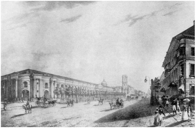
Figure 7.
Painting of Nevskii Prospekt.
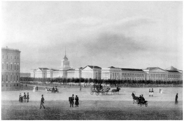
Figure 8.
Painting of corner near the Winter Palace.
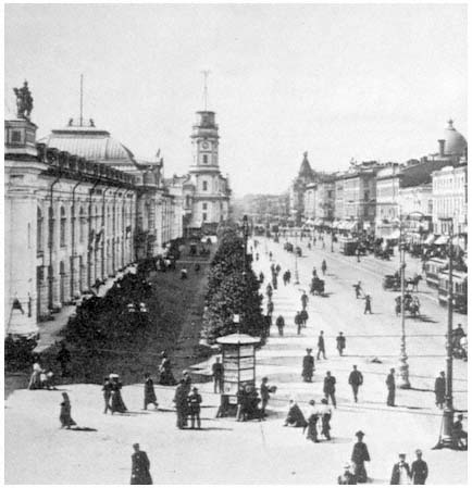
Figure 9.
Photo of Nevskii Prospekt at the turn of the century.
mortality rate even by urban Russian standards, the capital experienced fierce outbreaks of infectious diseases attributable in part to geography and climate and in part to municipal ineptitude. In addition, the city suffered from chronic epidemics of venereal disease, a high incidence of drunkenness, a soaring crime rate, abysmal housing conditions, and high levels of illiteracy.[20] St. Petersburg apartments housed twice as many people as apartments in the already overcrowded European capitals Berlin, Vienna, and Paris.[21]
Between 1870 and 1914, a million and a half new residents moved to the city; of these, a million came after 1890 and 350,000 arrived in the boom years of 1908 to 1913.[22] By 1914, when it was renamed Pet-rograd, the Russian capital was Europe's fifth largest city, surpassed only by London, Paris, Vienna, and Berlin. Its population and employment were dominated by businessmen and workers. Many of the latter,
however, had arrived fresh off the farm, as the city experienced its first major wave of migration from the countryside. The pressures of industrialization soon coincided with a rapidly escalating population, overwhelming municipal administrators. Housing and zoning codes were largely ignored, municipal services were far outstripped by demand, and the city's severe climatic conditions made a bad situation worse.[23]
The causes of the municipal administration's near-total collapse in the final quarter of the nineteenth century were cultural, structural, and financial. Russian society remained essentially preurban in outlook.[24] Prince and peasant alike regarded their residence in the capital as only transitory. For the nobility, St. Petersburg was the place to go for the winter social season. For the peasant, it was a place to earn money for the family back home. By harvest time many workers simply returned to the fields.[25] This generally low level of commitment to the city, combined with an autocratic administrative system, forced municipal officials to become more closely tied to the needs of the monarch than to those of the ostensibly passive populace. The city's largely underdeveloped municipal institutions retained essentially a static view of their role in a rapidly changing society.
One major reason for the municipality's apparent inaction remained financial. The city's operating budget was modest by European and even by Russian standards. City funds were derived largely from profits generated by such municipal concessions as the tram system, the water system, the gasworks, and a municipal slaughterhouse.[26] Under constant inflationary pressure, the city government eventually was forced to seek additional funds from the bond markets of London and Paris. The charges for servicing the municipal debt, while small by the practice of the period, nonetheless tripled between 1901 and 1910, reaching 2.9 million rubles annually.[27] In the end, the underdeveloped and underfinanced municipal structure was totally incapable of coping with the changes brought about by the industrial revolution.
Many in the city deplored the transformation of their capital from the relative order during the reign of Nicholas I to the growing chaos during that of Nicholas II. As industrialization swept across the Russian empire, antithetical nationalist and internationalist currents were felt throughout the capital's intellectual and cultural elites. In architecture, the nationalist movement shared broad concerns with the emergence throughout Europe of a romantic interest in the past.[28] As in Western Europe, this process of discovery took place in reverse chronological order, leading to an extensive eclecticism in design, which in St. Petersburg clashed with the city's predominantly classical spirit. Prime examples of this genre can be seen in the more "Russian" Moscow. In Petersburg, the Church of the Savior on the Blood, erected on the site of Alexander II's assassination, is the best local example of this drive
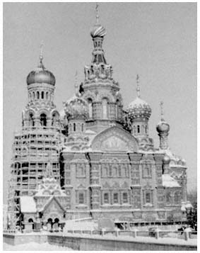
Figure 10.
Church of the Savior of the Blood.
to re-create a mythical national Russian architectural form (see Figure 10).[29]
Against this national romantic revival were posed the overtly internationalist predilections of those associated with the journal Mir iskusstva , which appeared from 1898 until 1904, as well as its successors Starye gody (1907–1916), Zolotoe runo (1906–1909), and Appolon (1909–1917). These journals represented the major Russian components of the international symbolist movement of the 1890s and early 1900s. Such groups were concentrated in the more Western-oriented capital, and were primarily attracted to the city's past, with the neo-classicism of Catherine II and Alexander I holding particular fascination for them. This movement's image was reflected in the works of the brothers Benois (Leontii and Alexander) as well as in Ivan Fomin's massive proposal for a "New Petersburg" project on Golodai (later De-cembrist) Island, a design every bit as classical in style and grand in execution as the original city (see Figure 11).[30]
These prerevolutionary reactions to the disintegration of the urban fabric caused by industrialization constitute the final imperial legacy for later generations of planners and architects in the Soviet period.
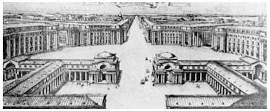
Figure 11.
Example of the "New Petersburg" project.
Their architectural strategies—which dismissed private property, demanded large-scale state intervention, and produced a style characterized by grandeur and unity—offered an urban vision that awaited an audience.[31] That audience was found by the end of the 1920s, as a new Stalinist cult of the state began to emerge, one that was receptive to fundamental characteristics of the Petrine-Catherinian-Alexandrine tradition of St. Petersburg as translated by the Mir iskusstva movement of the 1890s and early 1900s.
In the interim, the Bolshevik seizure of power on November 7 (October 24, Old Style), 1917 had unleashed a bloody civil war. By March 1918, Lenin was forced to transfer his government to the protective sanctuary of Moscow's Kremlin. With the seat of government removed to rival Moscow and with food supplies disrupted by fighting in the countryside, Petrograd residents fled their city. The gentry and merchant classes largely sought refuge abroad, while workers in many instances returned to their native villages or joined the Red Army. The city's population plummeted from a prewar high of 2,300,000 to a civil war low of only 720,000.
Once the new government had consolidated power and launched its New Economic Policy (NEP), designed to encourage small businesses, Petrograd—renamed Leningrad after Lenin's death in 1924—began to regain population. Still, with urban unemployment rates continuing high and trade flourishing in the countryside throughout the 1920s, its population remained well below pre-World War I levels. The launching of Stalin's collectivization and industrialization drive in 1928 unleashed yet another torrent of peasants fleeing the countryside. Every Soviet city expanded at unprecedented rates. The influx into Leningrad increased the local population by over 1.3 million between 1929 and the prewar census of 1939, which tallied a record population
of 3,119,000, with an additional 300,000 residing in the surrounding urban areas. This population increase combined with a revival of interest in grandiose neoclassicism to produce a distinctively Stalinist Leningrad.
Stalin's Soviet Legacy
The collapse of the Romanov dynasty touched off a vigorous anti-urban revolt among many intellectuals, particularly in the small community of professional urbanists and architects. At least among professional circles, this revulsion against the urban environment was centered in Moscow, where living conditions were every bit as pestilential as in Petrograd,[32] but where the city's physical unruliness offered none of the psychic relief provided by the lingering orderly aesthetic impact of the still-visible Alexandrine physical plant in Petrograd. In Petrograd, revulsion against the city's abysmal living conditions took a slightly different turn.[33]
As in Moscow, local Petrograd officials moved immediately to clean up particularly noxious neighborhoods.[34] Nevertheless, the local architectural community's image of the city remained essentially the original Romanov vision as transmitted through the prism of the "New Urbanism" of the city's turn-of-the-century artistic intelligentsia. The continued nurturing of this tradition by Leningrad architects throughout the 1920s psychologically prepared that community for Lazar Kaganovich's 1931 declaration that the Soviet Union's industrial future would be urban by definition.[35]
Immediately after Kaganovich's 1931 address, central elites instructed the city governments and Communist Party organizations in Moscow and Leningrad to prepare comprehensive physical development plans for their cities. In 1935 the Central Committee of the All-Union Communist Party (Bolshevik) and the USSR Council of People's Commissars joined with Moscow municipal institutions to promulgate a comprehensive plan for the reconstruction of Moscow.[36] The following year the same central institutions joined with the Leningrad city soviet to enact an equally far-reaching general development plan for the old imperial northern capital.[37]
According to the 1936 Leningrad general plan drawn up under the direction of Lev Il'in and Vladimir Vitman, the city would abandon its historic center focused on the Admiralty and Neva for a new and grander city center along an expansive boulevard (International [now Moskovskii] Prospekt) running directly south from the Peace Square for some ten kilometers (see Map 7).[38] This new city center, which together with the buildings of the 1920s has recently become a hub of historic preservation efforts,[39] was unified through a common focus on
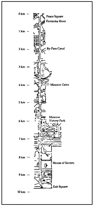
Map 7.
International/Moscow Prospekt project.
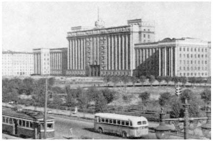
Figure 12.
House of Soviets building.
a gargantuan House of Soviets building placed strategically along the new thoroughfare.[40] That whole complex, when constructed, covered a total of 13 acres, nine of which were deemed to be usable building space.[41] Heavy and neoclassical, this ponderous building overwhelmed the as-yet vacant surrounding territory. The House of Soviets, and the 1936 general plan that produced it, captured not only the ethos of Stalinist statism but also that of the "New Petersburg" movement of three decades earlier (see Figure 12). This project represented the logical culmination of an imperial Petersburg tradition that sought to symbolize the pomposity of state authority in stone. Its neoclassical inspiration similarly testifies that the arrogant assertion of human order over nature, visible in the classicism of the Renaissance, continued to inspire imperial Russian and Soviet architects centuries later.
In his memoirs, Nikolai Baranov attests to the direct influence of Renaissance design principles and philosophy on his generation of Leningrad architects as they set to work during the Stalinist period.[42] Baranov, who was the city's chief architect from 1938 until 1950 and was one of the most influential Soviet city planners of his era,[43] reports that Lev Il'in, his predecessor as chief architect from 1925 until 1938, served as a primary mentor to the city's numerous young architects throughout the twenties and thirties (Il'in was later killed during a German bombardment of the city in December 1942).[44] Il'in, it turns out, collected eighteenth- and nineteenth-century furniture, paintings, carpets, china, and crystal.[45] He also compiled a 5,000-volume library of rare archi-
tectural works focusing primarily on the period of the Italian Renaissance, including works by Palladio, Alberti, and Piranesi.[46]
Il'in's chosen visual environment was that of Renaissance classicism and Russian neoclassicism. Through his thoughtful supervision of their work, he transmitted his aesthetic preferences to a generation of apprentice architects. Similarly, his own designs for Leningrad, as well as for Baku, where he also served as chief architect throughout most of the 1930s, displayed an intense interest in neoclassical principles.[47] Confronted with the strong neoclassical tradition of Leningrad and of its professional architectural elite, the new-found statism of the Stalinist regime saw in Peter's former capital a ready outlet for its pretensions.
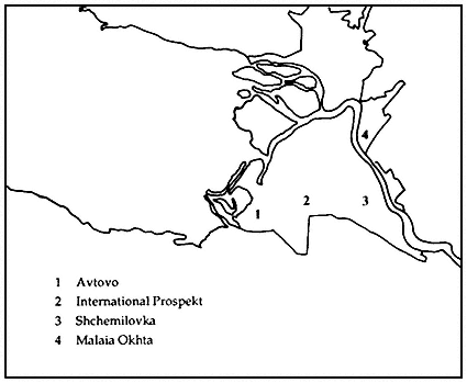
Soon, however, Leningrad city administrators came to view the initial 1936 general plan as impractical. In 1938, a team of architects under Baranov and Aleksandr Naumov revised the original plan, seeking a more effective use of the available land.[48] As part of this revision, the new city center project was scaled down from 99 acres to 28. Baranov later observed that this reduction brought the planned ensemble into scale with such urban vistas as the Mall in Washington, D.C., and the Champs-Elysées in Paris.[49] The new plan also noted that "serious inconveniences" would result from an immediate abandonment of the historic city center. Nevertheless, the primary thrust of new construction was still concentrated in the same four districts first designed in 1936: Avtovo, Shchemilovka, Malaia Okhta, and the International Prospekt Project (see Map 8).[50] From 1936 until 1941 more than 800,000 square meters of housing space, 213 schools, and 200 preschool facilities were built in the city, mainly in these four areas.[51]
Three overarching considerations explain the plan's preoccupation with moving the city's population southward. First, the new center was designed to overwhelm the historic city core, thereby destroying the political symbolism of the prerevolutionary architectural ensemble by erecting an even grander "socialist" statist environment nearby. Second, by moving the city to higher ground, the planners sought to reduce a tragic pattern of flooding. Third, once the decision was made to abandon the historic city center, movement to the south became inevitable. With the Finnish border only 22 miles to the north, national security interests demanded urban development in the opposite direction. The short but bloody Winter War with the Finns in 1939–1940 demonstrated the military wisdom of such a plan, as Leningrad was quickly transformed into a garrison city. Of the 200,000 Soviet casualties suffered in that war, by far the largest percentage were among Leningraders.[52] This loss was, of course, soon overshadowed by the virtual annihilation that occurred during World War II's blockade.
On the night of June 21–22, 1941, Hitler's Wehrmacht rolled across the Soviet Union's western frontier, and within a few weeks the
Map 8.
Major construction projects during the 1930s.
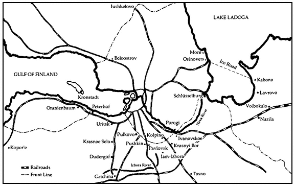
Map 9.
The front line on September 25, 1941.
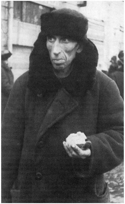
Figure 13.
Photo of effects of the blockade.
country's second largest city was under a siege that was to last two and a half years (see Map 9 and Figure 13).[53] The fate of over 40 percent of the city's prewar population is unknown and cannot be reconstructed from official Soviet statistics.[54] What is known is that, by early 1942, Leningrad's population had been cut by two thirds through war-related casualties, starvation (as many as 30,000 civilians died on each of the worst February days), and evacuation (over a half-million civilians successfully left the city on the 237-mile "Road of Life" across the ice of Lake Ladoga and through surrounding forests to the nearest railhead).[55] To put these figures into comparative perspective, the number of Leningraders who perished during the blockade approximately equals the total number of U.S. armed forces personnel who died in all wars from the American Revolution through the war in Vietnam.[56] By the end of the blockade's second winter, Leningrad had shrunk to only 639,000 residents—less than the city's population at the height of the Civil War—and its industrial base was operating at only 10 percent of its prewar capacity when measured by the value of industrial production.[57]
2
The Postwar City, 1945–1966
St. Petersburg, Petrograd had gone for ever. This was Leningrad. It had inherited many things from the other two, but it had its own substance, its own personality. . . . One no more felt like calling Leningrad "St. Petersburg" or "Petrograd" than one felt like calling Stalingrad "Tsaritsyn."
—Alexander Werth, 1944
Reconstruction
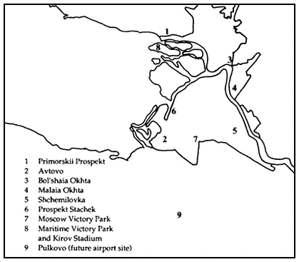
After March 1943, the city's fortunes began to improve, and the Finno-German blockade was lifted in January 1944. Later in 1944, when the city was fully liberated, the State Defense Committee in Moscow announced a plan for rebuilding Leningrad.[1] Recognizing that the population had fought and died for their "Peter," as residents affectionately called the city, the framers of the 1943–1947 reconstruction plan abandoned the previous effort to shift the city core southward and reasserted the primacy of Leningrad's historic center. For example, October 30 Prospekt once again officially became Nevskii Prospekt (while International Prospekt was also renamed, in honor of Stalin).[2] In 1945–1946 more than 700 million rubles were invested in the city's reconstruction, with 1.6 million square meters of housing erected in the traditional city center, as well as low-rise structures in the Primorskii Prospekt, Avtovo, Bol'shaia and Malaia Okhta, Shchemilovka, and Prospekt Stachek districts (see Map 10).[3] Gas heat was introduced on a large scale for the first time, and water and sewage systems were upgraded.[4] Two large victory parks were opened on Stalinskii Prospekt (the 250-acre Moscow Victory Park) and on Krestovskii Island (the 470-acre Maritime Victory Park).[5] The 1950 dedication of the 100,000-seat Kirov Stadium on that island marked the culmination of Leningrad's reconstruction period (see Figure 14).[6]
The placement of the massive Kirov Stadium along the Gulf of Finland reflected a new set of spatial priorities enunciated for the first time in a new 1947 general plan developed by a team of architects led
by Nikolai Baranov. The 1947 plan carried forward the city's development beyond the original postwar reconstruction period. Its overall conception for future development in Leningrad had several components that would dominate local city planning efforts for decades. In it, for example, Baranov set forth his pet notion that Leningrad should, at long last, become the true maritime city Peter I had initially envisioned.[7] He would later claim that the original idea for the city's "face to the sea" dated from the work of eighteenth-century architect Adreian Zakharov.[8] The 1947 general plan also anticipated new transportation facilities, with a major airport south of the city near the eventual site of today's Pulkovo airport.[9]
Despite these very real achievements, however, the final document—as with all Soviet general city plans of the period—largely ignored major social and economic trends then shaping the city's destiny. These forces rendered Chief Architect Baranov's plans fanciful and obsolete almost as soon as they left his drawing board. To fully appreciate how this was the case, it is necessary to review the entire postwar period down to the 1980s—a period of sweeping social and economic change in Leningrad.
Social Change
To begin with, a major social and demographic transformation was afoot. By September 1945, Leningrad's wartime population had doubled with the arrival of rural in-migrants (coming from such regions as Iaroslavl', Kalinin, Saratov, and Sverdlovsk oblasts) and demobilized soldiers (see Map 1).[10] In other words, a large number, perhaps even a majority, of the city's residents had not lived in the city before the outbreak of hostilities, had only limited personal or familial ties to the city, and, as a rule, had fewer work skills at the beginning of this migratory process than did the city's prior inhabitants.[11] It would take another decade and a half before prewar population levels would be achieved, but, by as early as 1945, Leningrad was becoming primarily a city of migrants. Such disproportionate reliance on migration as a source for new population magnified the demographic chasm created by the horrific civilian losses of the blockade.[12] Among the most visible manifestations of this intense social change have been the "feminization" and aging of the city's inhabitants throughout the postwar period.[13]
Fortunately for local economic and civil leaders, Leningrad continued to attract significant numbers of migrants well into the 1980s, with net annual increases through the 1960s and 1970s running mostly in the 20,000 to 40,000 range, so that the city's population has continued
Map 10.
Major postwar construction projects.
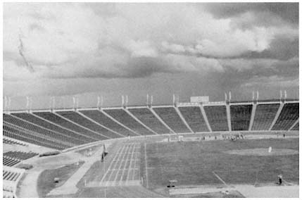
Figure 14.
Kirov Stadium.
to grow at a rather robust pace.[14] This ability to attract migrants reflects in large measure a general transfer of population from the Soviet countryside to urban centers. Nationally, each year from 1951 to 1974, an average of 1.7 million people moved from country to city.[15] Until very recently, this national pattern was magnified in the Northwest Economic Region around Leningrad (see Map 1), where demographer Grigorii Vechkanov had found that 70 of 100 school-age residents in selected rural districts left home to pursue educational opportunities in towns and cities.[16] This large-scale out-migration from nearby rural areas may finally have come to an end during the 1980s, although more data are necessary to verify a trend.[17]
National or even regional trends do not suffice to explain the city's continued attractiveness to migrants. The city's migrant profile demonstrates several rather singular characteristics. In the late 1970s, for instance, much of the city's in-migration consisted of young people attracted by Leningrad's numerous and, by reputation, high-quality educational establishments.[18] By decade's end, over a quarter-million students from all over the USSR were enrolled in the city's institutions of higher learning.[19] The possibility that many students manage to stay in the city after graduation is suggested by available data on the skills and educational levels of the population. These data indicate that the number of specialists in Leningrad with higher or specialized secondary education doubled between 1965 and 1980 alone.[20] Moreover, the city's
general level of educational achievement remained well above the national norm down through at least the 1970s.[21]
The Leningrad population's steady improvement in educational attainment may help compensate for the growing proportion who receive some form of pension or social insurance payment (nearly 25 percent, or 1,064,000 people, on January 1, 1982).[22] The city's elderly may form the core of a potential poverty problem since, nationally, a high correlation may be found between the number of pensioners and the number of residents below the official poverty level, which, during the mid-1970s, was set at a monthly per capita income of about 50 rubles.[23] The strain imposed by the large number of older dependents relative to the working population of Leningrad is apparent even in the limited summary data available on Soviet city budgets. In 1975, 0.8 percent of the average Soviet city budget went to social security payments,[24] whereas in Leningrad nearly 5 percent of the city budget was consumed by such obligations around that time.[25]
Another distinctive characteristic of Leningrad's migrant population has been that it now hails from nearly every economic region of the USSR.[26] Recent migratory data demonstrate that Moscow and Leningrad now stand alone among Soviet metropolitan centers in their sustained ability to attract new population from every corner of the Soviet Union. As the national capital, Moscow remains the single most important political, economic, educational, and cultural center for the country as a whole. In the case of Leningrad, the continued drawing power of the city's educational institutions undoubtedly explains the pattern to a considerable degree. In addition, major construction projects, such as the massive Gulf of Finland dam and flood control project, attract skilled labor from across the USSR.[27]
Ethnic Diversity
Whatever the motivation for moving to Leningrad, such continued migration has not substantially altered the Russians' overwhelming dominance of the town. Leningrad is a city where over 150,000 persons have the characteristically Russian last name Ivanov, over 300 are named Maria Krasovskaia, and over 200 are named Sergei Bobrov.[28] The city's urban diversity peaked as long ago as the time of the 1897 census, when there were over 60 ethnic groups represented in the city.[29] Still, migration throughout the postwar period has brought relatively large increases not only in the city's Russian population, but also especially in the Ukrainian, Belorussian, and Tatar populations (see Tables 2 and 3 and Map 1).
Large-scale Ukrainian and Belorussian migration to the city began over a century ago.[30] The emancipation of the serfs in 1861, combined
| ||||||||||||||||||||||||||||||||||||||||||||||||||||||||||||||||||||||||||||||||||||||||
| ||||||||||||||||||||||||||||||||||||||||||||||||||||||||||||||||||||||||||||||||||||||||
with the country's burgeoning industrialization, encouraged peasants of both nationalities to move to the city. Between the 1869 and 1897 censuses, for example, St. Petersburg experienced a sharp decline in the absolute and relative numbers of migrants from the gentry of these and all other nationalities, and a concomitant increase in the absolute
and relative numbers of peasant-migrants.[31] This trend was particularly pronounced among the Ukrainians and Belorussians.
Ukrainian migration to the city was relatively low throughout the late nineteenth century, in part because of the relative well-being of the Ukrainian countryside and in part because of the existence of alternative magnets—industrializing centers in the Ukraine such as the Donbas region.[32] During the twentieth century, and especially in more recent years, Leningrad's Ukrainian population began to grow more rapidly, so that by 1979 it had come to constitute the third largest ethnic group in the city behind the Russian and Jewish populations (see Table 3).
Belorussian migration to St. Petersburg/Leningrad has remained high ever since the emancipation of the serfs.[33] This pattern is a consequence of the relatively poor rural living standards in Belorussia, as well as the region's geographic proximity to the city. Prior to the Bolshevik Revolution, Roman Catholic peasant migrants from the Belorussian countryside were drawn to Polish cities, while their Orthodox brethren moved to St. Petersburg.[34]
Recent ethnographic research helps elucidate the underlying motivations for the continuing Tatar migration evident in Tables 2 and 3.[35] Tatars first arrived in the city during the late eighteenth century and, by the middle of the nineteenth, had become prominent in trade. The city continued to attract significant numbers of Tatar migrants throughout the Soviet period until the 1980s.[36] Today's Leningrad Tatars retain a strong ethnic identity across generational and educational barriers, as evidenced in widespread fluency in their native language and observance of traditional holidays. More than half migrated from rural areas, about a quarter from multiethnic cities, and the remainder from small towns scattered throughout the Tatar ASSR along the Volga River (see Map 1).[37]
The conspicuous decline over time in the local Jewish and Polish populations reverses historic trends and can be attributed in large part to the idiosyncratic status of both national groups in the contemporary Soviet scene. Their status reflects both national and international influences rather than purely local ethnic impulses and tendencies. For example, Jewish migration during the nineteenth century was adversely affected by laws and regulations governing Jewish settlement. Consequently, the largest migration of Jews to the city came during the early Soviet period, when such restrictions were removed.[38] The decline of the city's Jewish population more recently reflects local discriminatory practices that have prompted many Jews to leave Leningrad for Moscow, Israel, or the United States. A different pattern holds for the Poles, many of whom chose to return to their homeland following the establishment of an independent Poland at the close of World War I.[39]
Economic Change
The sweeping social changes just chronicled have been reflected in and are a consequence of significant economic transformations that have been taking place in Leningrad since the lifting of the blockade in 1944. To appreciate the extent of these trends, it is important to recall that St. Petersburg long served as an industrial center of considerable significance. Despite several distinct disadvantages—the city's location on the outer edges of Russia and Europe, its adverse climate, its lack of ready access to natural resources and to markets, and so on—in its early days the capital soon developed a small, primarily state-supported industrial base oriented toward the needs of the local economy and those of the emperor's army and navy.
By the late nineteenth century, the city had emerged as the focal point of one of the more powerful industrial regions in Europe. Until the Bolshevik Revolution, however, the city's industrial base continued its dependency on foreign and state capital markets, as well as on imported raw materials and finished manufactured goods brought in through its expanding port. As Steven Smith has suggested, by the outbreak of World War I, the city had come to represent a unique island of technologically sophisticated state-supported industrial production.[40] Unlike the more diversified industrial base in Moscow, St. Petersburg's industry remained heavily concentrated on such state-dependent large-scale industries as metalworking and chemical production.[41] Consequently, the city never came to hold overall sway in the Russian national market the way Moscow would.
St. Petersburg ultimately failed to retain national economic preeminence for numerous complicated reasons beyond the scope of this particular study. Certainly, the transfer of political power from the city in 1918 guaranteed Moscow's dominant position for the remainder of this century. However, other factors contributed to Moscow's relative economic power, even before the Bolsheviks moved their government. For example, by the late years of the nineteenth century it had already become apparent that St. Petersburg would not develop into an "import-replacing" city.[42] This failure was expressed in the city's historic and continuing inability to create an exuberant and productive city-region. Such areas manifest intense and diverse rural, industrial, and commercial activity tied together by the import-replacing city's overwhelming economic energy.[43] This all-encompassing dynamism can exist only when a city replaces its imports with internally produced products—a feat never accomplished on a sufficiently large scale to secure St. Petersburg/Leningrad's economic power over Moscow.
Initially, St. Petersburg's continued dependence on imported goods helped the capital emerge as a major transportation center, de-
spite its peripheral location. By 1851, Russia's first major railroad connected the capital's port to Moscow, and the next year, 38 percent (by value) of all Russian foreign trade passed through St. Petersburg (representing five times the value of foreign goods passing through the second largest port—Riga).[44] This preeminence was challenged as early as the century's end, once new rail lines linked Moscow and Odessa, Moscow and Riga, and eventually Moscow and Warsaw (and through Warsaw, directly with the heart of Europe). These developments emphasized St. Petersburg's numerous geographic limitations.[45]
Over the years of Soviet rule, Leningrad political elites and economic and urban planners have developed four distinct strategies to overcome economic and geographic liabilities:
1. Political laissez-faire . Reliance on political patronage ties to secure economic resources within the context of a decentralized, mixed state-private economy (1917–1926).
2. Skilled diversification . Reliance on a skilled labor force, an extensive heavy and defense-related industrial base, and a major light-industrial capacity to fuel economic expansion (1926–1945).
3. Consumer-oriented internationalism . Reliance on expanded consumer goods production, extensive trade with the West, and a disproportionate claim to postwar reconstruction funds to lead economic recovery (1945–1948).
4. Skilled specialization . Reliance on a skilled labor force, an increasingly specialized heavy and defense-related industrial base, and, especially since 1951, a leading scientific infrastructure combined with a reduction in light industrial capacity to sustain economic growth (1951–present).
The fourth and most recent strategy—skilled specialization—has significantly altered the contour of the city's economy to the point where a new Leningrad economic structure may be said to have emerged over approximately the past three to four decades. The focus of this study is principally on this new Leningrad as a special case of Soviet regional management. Before discussing the fourth strategy in greater detail, however, we should briefly review its predecessors.
The initial response (1917–1926) to the city's precipitous decline during the Civil War was largely political. The city's Communist Party organization remained subjugated to the whim of Comintern Chairman Grigorii Zinov'ev. Zinov'ev, who succeeded Leon Trotsky as Petrograd city soviet chairman in 1917, attempted to use his Petrograd post and power base to challenge Joseph Stalin for party leadership during the mid-1920s.[46] By 1926 Zinov'ev had lost that quest, as Stalin had members of Zinov'ev's "Left" opposition expelled from major party posi-
tions. Control over the Leningrad party organization quickly passed to a new regional party first secretary, Sergei Kirov.
Before being removed from his Leningrad posts, Zinov'ev had paid far greater attention to the care and maintenance of a loyal political machine than to the city's economic recovery. In short, his strategy, as well as that of his planners and managers, appears to have been simply not to develop a coherent response to the threat of permanent economic decline. Although Petrograd/Leningrad slowly managed to regain its population and economic base throughout the early and mid-1920s, the lack of a sustained program of economic development severely limited the scope and durability of that recovery.
Both Kirov and, following his assassination on December 1, 1934, Andrei Zhdanov, his successor as regional party first secretary, tried to build on their city's historic economic strengths (a skilled labor force, an extensive heavy and defense-related industrial base, and a major light-industrial capacity). This second Leningrad development strategy of the Soviet period (1926–1945), which conformed closely to that of the national five-year plans, catapulted the local economy into preeminence in numerous areas of highly sophisticated industrial production. By the eve of World War II, the city had reemerged as the Soviet Union's leading center for industrial innovation.[47]
The third approach to economic development proclaimed by the city's postwar leadership proved short-lived (1945–1948), quickly becoming entangled in some of the most bitter and destructive political struggles of Soviet history.[48] Leningrad elites of the period were outspoken proponents of major policy positions that subsequently failed to gain Stalin's endorsement.[49] For example, as early as June 1945, Aleksei Kuznetsov (who had replaced Zhdanov as Leningrad regional party first secretary earlier that year) argued before a joint session of the Leningrad regional and city party committees that the Communist Party should assume full responsibility for guaranteeing "normal relaxation," now that the war was over.[50] Kuznetsov repeated this theme in an address launching the 1946 Supreme Soviet campaign in Leningrad,[51] as did Zhdanov (who was now a member of the national Central Committee Secretariat in Moscow) in a remarkable address to the residents of Leningrad's Volodarskii Election District during that same campaign.[52]
While other national leaders of the period typically ignored local concerns in their election speeches,[53] Zhdanov relied heavily on his wartime experiences in the city to advocate policies designed to improve the quality of life of Leningrad citizens. The new Leningrad economy, Zhdanov argued, would be based on consumer-goods production, extensive trade with the West, and a disproportionate claim to postwar reconstruction funds. He thus linked Leningrad's resurgence
to particularly volatile leadership struggles in Moscow over the Soviet Union's peacetime relations with wartime allies and, ultimately, to his own fate.
Following Zhdanov's death in August 1948, his major rivals, Georgii Malenkov and Lavrentii Beria, set in motion a large-scale purge of Zhdanov protégés in Leningrad and elsewhere. Numerous Leningraders holding national posts together with nearly all senior city and regional officials were removed from their positions, never to be seen again, in what has become known as the Leningrad Affair.[54] Beyond Leningrad, in Gorky (previously Nizhnii Novgorod), where Zhdanov had served prior to his arrival in Leningrad, numbers of leading Communists also fell victim to the "provocative Leningrad Affair, fabricated by Malenkov."[55]
The conventional explanation of the affair interprets the events of 1948 and 1949 as a consequence of Zhdanov's protracted struggle for power with Malenkov. Robert Conquest, for example, observes that the one uncontestable outcome was for Zhdanov's men to be replaced by Malenkov's.[56] The few Soviet accounts of the Leningrad purges that have thus far come to light—including Mikhail Gorbachev's mention of these events in his address commemorating the seventieth anniversary of the Bolshevik Revolution—are not strikingly different from that offered by Conquest.[57]
Recently, Western analysts have identified policy issues within the personal struggles of the period. Werner Hahn identifies multiple and linked areas of policy concern that might underlie the purges of 1948 and 1949: the nature of Soviet relations with the West, the possibility of reorientation of the postwar Soviet economy toward consumer industries, and the distribution of a majority of reconstruction funds to "front-line" regions such as Leningrad (as opposed to "home-front" areas to the east).[58] The precise role that any one of these issues played in the Leningrad Affair is likely to remain uncertain. Nevertheless, one should note that Leningraders' ultimately unsuccessful plans for a postwar reorientation of their region's economy were tied to improved relations with the West, a reorientation of the economy toward consumer-goods production, and a disproportionate claim to postwar reconstruction funds. In this respect, Leningrad's resurgence became inexorably linked to Moscow's leadership struggles in a particularly explosive fusion of local and national politics. This blend ultimately proved the undoing not only of several senior Leningrad political officials and scores of their protégés, but also of their strategy of economic revitalization through the expansion of consumer industries and international trade.
Following the extensive purges of Zhdanov associates during 1948 and 1949, local leaders, together with their partners and sponsors in Moscow, returned to the basic strategy of the 1930s, but with several
important variations. In many ways, this fourth approach (1951–present) was merely a modification of the growth strategy of the prewar five-year-plan periods, relying on heavy-industrial production and technological innovation. Nonetheless, the current strategy varied from its predecessors in being predicated on economic specialization rather than diversification. Moreover, since the Fifth Five-Year Plan (1951–1955), the strategies have relied more explicitly on the interaction of science and industry than in the past. This fourth approach to Leningrad's economic development—the focus of the policy studies to follow—remained in force from the 1950s through the 1970s and was incorporated into the Leningrad general plan for 1986–2005.[59]
Its durability suggests that we must assume this latest approach to economic development has in fact come to represent an accepted official view of Leningrad's role in the national Soviet economy. Although it would be misleading to identify this most recent Leningrad growth strategy with any single official, we can turn to the pronouncements of two Leningrad regional party first secretaries—Frol Kozlov, who held the post from 1953 until 1957, and Grigorii Romanov, the incumbent from 1970 until 1983—for comprehensive recitations of this latest strategy for the city's economic development. While this rhetorical device allows us to examine the period under consideration by focusing on two end points, it should in no way be taken to mean that Kozlov and Romanov monopolized leadership during the past three and a half decades. Regional party first secretaries Ivan Spiridonov (1957–1962), Vasili Tolstikov (1962–1970), Lev Zaikov (1983–1985), and Iurii Solov'ev (1985–1989), as well as scores of other local and national political leaders, have also played critically important roles in developing this present-day regional economic strategy.
Kozlov's Development Strategy
Throughout the 1950s, Frol' Kozlov, initially as city party first secretary, then as regional party second and first secretary, and later as first deputy prime minister of the USSR, vigorously advocated the reorientation of the Leningrad economy around technologically specialized industrial production. This orientation conformed with his views on the national economy; in fact, some Western analysts see Kozlov as having led coalitions opposing Khrushchev's plans to shift national resources from industry to agriculture and light-industrial production.[60] In addition to an emphasis on heavy-industrial production, Kozlov argued that, given Leningrad's extensive scientific research community and its famous industrial plant, the city could come to serve very specific functions within the overall Soviet economy: those of innovator, producer of high-quality industrial goods, and leader in
precision-instrument making.[61] To Kozlov's mind, such a growth strategy would necessitate a phasing out of the city's light-industrial capacity—a goal quite at variance with the strategy of industrial diversity followed by previous Leningrad leaders.
Jumping ahead to the period of Grigorii Romanov's tenure as regional party first secretary, we find remarkably few changes in the rhetoric of Leningrad economic development.[62] More importantly, that strategy had come to fruition (in large part because of the specific policies examined later in this volume). The realization of this growth strategy, as seen in the growing dominance of machine and metal industries, and the accompanying decline in chemicals and petrochemicals, forestry, construction material, food processing, and other light industries, is a direct consequence of industrial investment policies.[63] The achievement of this pattern must be considered all the more striking when compared to trends in the Moscow and national Soviet economies and when taking into account the demographic trends described earlier, most of which inhibit the expansion of the workforce available for service in heavy industry (see Table 4).
Meanwhile, the role of science and related services in the Leningrad economy has expanded. By the 1970s, scientific and related institutions represented the city's second largest employer, behind industry.[64] The city's scientific research establishments and institutions of higher learning employed almost one fifth of the Leningrad work-force, and the city was second only to Moscow in the number of scientific workers employed in the local economy.[65] In 1982, one in 11 Soviet scientists worked in Leningrad, and a much higher share of the country's skilled specialists were to be found there.[66]
The close interaction between the city's enormous scientific community and its powerful industrial base is apparent in an emphasis on applied rather than basic research—an emphasis reflected in the distribution of Leningrad scientific workers by discipline during the 1970s.[67] Leningrad party leaders are quick to point out that the mission of the newly constituted Leningrad Scientific Center of the USSR Academy of Sciences, which was established in March 1983 by bringing together under a single institutional umbrella preexisting academy research institutes, was to improve the coordination of basic and fundamental research on the one hand and industrial activity on the other.[68]
The increasingly close coordination of Leningrad's scientific and industrial organizations pushed the city ahead of all other Soviet industrial centers in various measures of technological innovation. According to Leonid Bliakhman of Leningrad's Institute of Socioeconomic Problems, during the mid-1970s the city led the Soviet Union on a per capita basis in the annual economic impact of the introduction of new technologies into production, the number of new types of machines
| ||||||||||||||||||||||||||||||||||||||||||||||||||||||||||||||||||||||||||||||||||||||||||||||||||||||||||||||||||||||||||||||||||||||||||||||||||||||||||||||||||||||||
generated annually, and the number of newly automated production lines.[69] By the early 1980s, 9 percent of all new Soviet production technologies were being developed in Leningrad.[70] These innovations may help explain how Leningrad plants produced 10 percent of all export machinery, 52 percent of all turbines, 52 percent of all generators and 26 percent of all printing facilities, even though the city's economy constitutes but 3 percent of the Soviet Union's total national industrial capacity.[71]
The implementation of this economic development strategy contributed to the transformation of the city's industrial profile and the emergence of linkages and cooperation among local industrial and scientific organizations. In the short term, this strategy has been a success, as the city has achieved respectable rates of economic growth.[72] We should note further that such growth has occurred in part because Leningrad's dominant economic sectors (machine construction, shipbuilding, and other heavy industries) are precisely the sectors that have expanded the most throughout the Soviet Union during the past 30 years.[73] In this sense, then, the strategy may represent nothing more than the effective local implementation of national priorities. Whichever came first, the Leningrad approach or the national goals, it is clear that Leningrad benefited from central investment and growth patterns.
Spatial Consequences
These sweeping social and economic changes of the postwar period proved to have significant consequences for the physical organization of the city and its metropolitan region long before the 1947 general plan could be revised. For example, the city's sustained ability to attract migrants, noted earlier, combined with a massive housing construction effort to meet the needs of those migrants to produce extensive urban sprawl. In 1951, an average of 3.3 families lived in each Leningrad apartment.[74] Beginning in the mid-1950s, Leningrad construction trusts, in accord with Khrushchev's housing program, began expanding the city's housing stock at an ever-accelerating rate.[75] During most of the 1970s, for example, the average per capita living space available in Leningrad grew at a rate exceeding that of other major Soviet urban centers.[76] Despite a slowdown later in the decade, it is obvious that the city has begun to approach the national average of 80 percent of all families living in their own apartments (see Figures 15 and 16).[77] At the end of 1979, for instance, a Leningrad family of four would occupy, on the average, 684.4 square feet of living space—the size of a moderate one-bedroom apartment in New York. While many North Americans or West Europeans would probably consider this inade-

Figure 15.
Apartment buildings along Nevskii Prospekt.
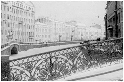
Figure 16.
Apartment buildings seen from the Moika River Canal
with the Pevchevskii Bridge in the foreground.
| ||||||||||||||||||||||||||||
quate, it represents an enormous improvement over the dreadful housing conditions of 1951.
Such achievements have not come without cost to the urban environment. In search of land for their gargantuan housing projects, local planners quickly turned to vacant sites beyond the city's boundaries. As the years have passed, successive layers of housing superblocks have built up, much as polyps build their coral reefs (see Table 5; Maps 8 and 10; and Figures 17–19). The city of Leningrad swelled from 323.4 square kilometers in 1957 to 570 in 1974.[78] This prodigious spatial growth transformed what had remained for many inhabitants a cozy nineteenth-century walking city of just 105.4 square kilometers in 1917 into a massive metropolitan agglomeration extending over 1,359 square kilometers in all by 1980.[79]
Unlike much of the urban sprawl in the West, local planners have relied extensively on subway-based mass transportation, rather than on the private automobile. This growth strategy inhibited the emergence of an efficient and flexible regionwide service, commercial, and cultural infrastructure. Except for Moscow and the largest cities of the People's Republic of China, no other urban center of comparable size has experienced such immense territorial expansion without reliance on the private automobile. If the historic central city could be traversed on foot, the new Leningrad of the late twentieth century must be crossed by wearisome bus, streetcar, and subway rides (see Figures 20 and 21).
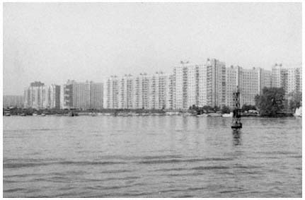
Figure 17.
View of housing superblock on Vasil'evskii Island.
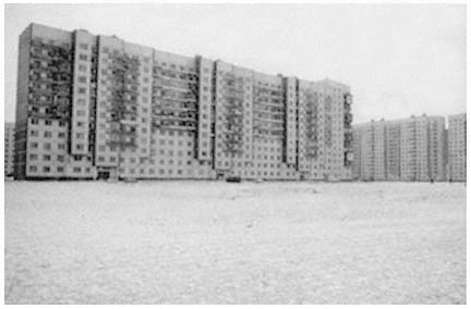
Figure 18.
Minidistrict.
Figure 19.
Small Avenue on Vasil'evskii Island. Examples of the old and new styles.
Figure 20.
Pedestrians in front of the old Singer building, now the House of Books.
Figure 21.
Streetcar on Middle Avenue on Vasil'evskii Island.
And traversed it must be, for housing and population have both moved outward (see Table 6). Fleeing decrepit communal apartments downtown, both residents and recent arrivals from the countryside have filled the massive new districts ringing the former city center. As a result, the city's center increasingly is becoming a home to students and pensioners—two groups requiring less personal space—while the typical Soviet family of three (parents and a single child) are relocating further and further out (see Table 7). This trend has placed considerable pressure on the service infrastructure of Leningrad's new districts.
Industrialized Construction and Superblocks
Once one moves beyond the city's historic center into these massive new neighborhoods, Leningrad becomes a far less special—and more typically "Soviet"—city. Quite early on, postwar municipal leaders created several new institutions to streamline and improve the planning and the design of these new districts, in accord with Baranov's 1947 general plan.[80] They also sought to speed up the construction cycle. In 1955, for example, the Main Leningrad Construction Administration (Glavleningradstroi) commenced operations, with the Main Leningrad Construction Materials Administration (Glavlenstroimaterialy) following suit a year later.[81] These bodies are the Leningrad offices of the State Committee on Construction and the State Committee
| ||||||||||||||||||||||||||||
| ||||||||||||||||||||||||
on Construction Materials, two agencies of the USSR and the 15 union republic councils of ministers charged with responsibility for directing the construction industry throughout the nation. In Leningrad, the trusts operate within departments and main administrations of the Leningrad city soviet. They are among the largest administrative agencies of the city soviet, with the Main Leningrad Construction Administration, for example, operating nearly two dozen smaller construction
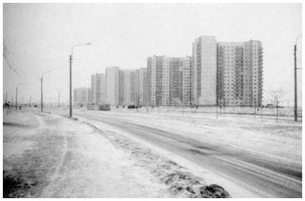
Figure 22.
Example of the new minidistrict.
firms. One such firm, the first Housing Construction Combinant (DSK no. 1) opened for business during the 1950s.[82] In short, Glavleningradstroi and Glavlenstroimaterialy are the Leningrad construction industry.
Leningrad quickly emerged as a pioneer in large-scale industrialized construction methods. The Soviet Union launched the world's most ambitious housing construction program after a July 1957 party and state decree on the further development of housing construction.[83] This effort relied on the introduction of assembly-line production of prefabricated building units. This so-called block-section construction technique, now used throughout the Soviet Union, was largely developed and perfected in Leningrad during the late 1950s and early 1960s.[84]
Widespread utilization of the block-section method produced a network of instant neighborhoods as enormous housing projects sprang up in a matter of months. These superblocks or minidistricts (mikroraion ) became inexorably linked to the introduction of new construction technology.[85] The minidistrict—a planning rather than a political unit—can be traced to the European modernist tradition (see Figure 22). It represents an effort by the architects and planners involved to create safe and attractive residential districts by removing all basic neighborhood functions from the street, streets being viewed as dangerous, chaotic, and generally inhospitable environments. Urban designers therefore anticipated that developing social amenities in self-
contained communities would make such services more convenient and accessible to larger numbers of citizens.[86] In the Soviet Union the concept evolved considerably, so that a complex doctrine concerning the minidistrict had emerged by the 1970s.[87]
Leningrad architects now generally view the minidistrict as an extension of the Petersburg tradition of grand ensembles. Few casual observers can distinguish Leningrad's standard new minidistricts from those found in Moscow and in such typical provincial cities as Sverdlovsk in the Urals and Vladivostok on the Pacific coast. A handful of experimental minidistricts that are spread throughout the city's new developments undeniably benefit from greater concern for aesthetics than do the typical residential districts in other Soviet communities.[88] Nonetheless, the emergence of industrialized construction techniques, the commitment to mass-scale housing, and the rigid control of construction agencies have generally produced mile upon mile of low-grade and unimaginative structures, both in Leningrad and elsewhere in the Soviet Union.
The 1966 General Plan
By the early 1960s many municipal officers saw that Baranov's 1947 plan had outgrown its usefulness. A new and more comprehensive plan was now needed for the effective management of the city's continuing development and growth, especially in the new minidistricts being built by a technology that did not exist when Baranov's plan took effect.[89] Moreover, the Soviet architectural community was slowly emerging from its Stalinist isolation. In 1958 the World Congress of Architects met in Moscow, and in 1960 the All-Union Conference on City Planning convened the first gathering of its kind in years.[90] These meetings mark the initiation of the post-Stalinist thaw in architecture and planning, a thaw that came just as work began on a new 25-year general plan for Leningrad's development that was to take effect in 1966.[91]
In 1966 the USSR Supreme Soviet enacted the General Plan of Development of Leningrad and the Leningrad Suburban Zone, in accordance with a draft prepared over a seven-year period by Leningrad city planning agencies—especially the Main Architectural Planning Administration—and endorsed by the Leningrad city and regional soviets and party committees.[92] The city soviet's Main Architectural Planning Administration was established to formulate not only the general plan for the city, but also various thematic and district plans that elaborate future construction in the city for up to 30 years. A parallel institution to Glavleningradstoi, the city soviet agency responsible for construction activities, the Main Planning Administration submits draft
plans for review and approval by the city soviet. At various points in Leningrad history, there has also been an office of the chief architect subordinate to the Main Architectural Planning Administration. At present, the position of chief architect is distinct from the main administration, reporting in parallel fashion directly to the city soviet's executive committee. While the chief architect is responsible for the city's architectural integrity, the Main Architectural Planning Administration has assumed full authority over the preparation of the increasingly multipurpose general plan.
Once approved at the city level, a draft general plan must then be approved by the Leningrad regional soviet and passed as a state law by the USSR Supreme Soviet. As will become apparent in our discussion of the 1986 general plan, changes may be introduced at any stage prior to the plan's enactment as law. This review process is complicated by party oversight at every stage. Although party agencies do not have formal legislative authority, no draft general plan will be ratified by a soviet until the parallel party committee has approved it. Each review prolongs the planning process—helping to explain why it took seven years to prepare the 1966 general plan. None of these reviews are public, however, as the actual plan document is classified as secret for reasons of national security.
Once completed, the 1966 plan provided a general urban orientation to coordinate and provide direction for future regional components of national economic and technical plans—the five-year plans—during the next quarter century. Put forward and implemented under the direction of the city's chief architect, Valentin Kamenskii, the document drew explicitly on the city's planning and architectural traditions.[93] The existing historic city center was as much of a model for this new projection of Leningrad's future as were central decrees emanating from Moscow.
Seeking to create a more salubrious urban environment, the creators of the 1966 general plan shifted the focus of construction toward the Gulf of Finland. Thus, the low-lying areas near the coastline were to become the city's focal point. As noted earlier, this "movement to the sea" had first been proposed in the 1940s by Nikolai Baranov. It required the elevation of the low-lying areas by extensive landfill and flood control projects, as well as the construction of massive housing projects on reclaimed land at the western tip of Vasil'evskii Island and in the southwest.[94] The plan also provided for the development of major recreational facilities to the northwest along the Gulf of Finland. Such movement to the north and west became acceptable from a strategic point of view once the international boundary with Finland had been shifted from 22 miles away from the city to over 100 miles distant as a consequence of the Soviet victories in the 1939–1940 Winter War and World War II. More detailed plans for the city's 16 districts were
developed to further refine general planning objectives (see Map 11).
The 1966 plan enumerated eight primary objectives that deserve special attention:[95]
1. Limitation of population and territorial expansion
2. Movement to the sea
3. Creation of new districts
4. Historic preservation
5. Improvement of intraurban transportation and communications
6. Development of the city's scientific traditions
7. Improvement of transportation approaches to the city
8. Satellite cities, greenbelts, and regional planning
Limitation of Population and Territorial Expansion
The chief goals of all Leningrad plans throughout the Soviet period have included the limitation of population growth, reduction of population densities, and minimization of built-up territories.[96] Despite repeated failures on each of these fronts, the 1966 general plan continued to restate population targets that had already been overtaken or would soon be. Under the provisions of the plan, municipal officials were to limit the city's population to 3.5 million residents by 1990. Gosplan, the State Planning Committee in Moscow, also projected a ceiling of some 4 million persons tied in one way or another to the city's economy. By 1970, these figures were already surpassed.[97]
During preliminary discussions of the plan, as early as 1960, Valentin Kamenskii had identified the need to limit urban sprawl by concentrating territorial development in a few areas.[98] Provisions to implement Kamenskii's proposals found their way into the 1966 general plan. Accordingly, city officials were to contain the area of urban development within 200 square miles, of which 185 were to be in use by 1990 (as opposed to 107 square miles in 1966).[99] Moreover, the city's population was to be distributed more evenly throughout Leningrad, with inner-city districts losing population to outlying regions. To a considerable degree, this last plan projection has been fulfilled.
Movement to the Sea
By the mid-1960s, Aleksandr Naumov had endorsed various proposals to redirect Leningrad's development in the direction of the Gulf of Finland.[100] Nikolai Baranov supported Naumov's efforts, characterizing this attempt "to reorient the city and to turn it into a real maritime city" as one of the most successful elements of the new general plan.[101] In its final form, the 1966 plan provided for the widespread develop-
Map 11.
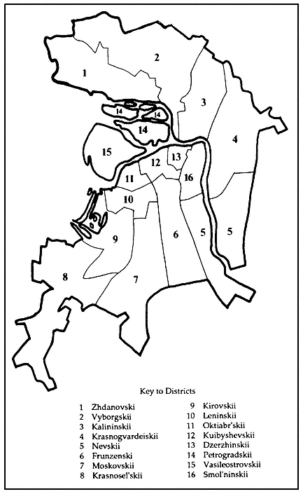
Districts (raiony) of the city of Leningrad.
ment of the regional shoreline—especially of the gulf's north shore—for recreational use.[102] This vision was based on extensive analysis of the region's geological conditions:[103]
1. The shoreline areas would have to be elevated, with bogs and swamps being drained in the northwest and southwest.
2. The best site for a new airport was to the city's south, a location that would limit population expansion in that direction.
3. The best lands for agricultural production were to the north, northeast, and southeast.
4. Urban development would have to be limited to landfill areas in previously undeveloped lands of the Neva floodplain.
On the basis of such surveys, the planners suggested that a combination of landfill and flood control—including the construction of the aforementioned dam across the gulf from Lomonosov through Kronstadt to Gorskaia—could prevent major flooding (see Map 12).[104] Accordingly, specific construction plans were developed for high-density experimental housing districts on the west end of Vasil'evskii and Dekabristov islands and along the Neva to Rybatskoe and the gulf north to Ol'gino.[105]
Creation of New Districts
Increasing population, combined with a policy of reduced population densities, created pressures for the rapid development of new housing stock in outlying areas. The 1966 general plan projected the construction of scores of new minidistricts with up-to-date cultural, economic, and educational amenities. Forty-five percent of all new housing was charted for areas north of the city, and 50 percent to the south, with the remaining 5 percent to be built in the existing city (primarily on Vasil'evskii and Dekabristov islands).[106] These apartment buildings were to be constructed in accordance with the most recent industrialized techniques in districts located in a circle around the historic city center. During the plan's first eight years 393,000 apartment units were completed and made available to 1.25 million residents.[107] But, as will be discussed later, local architects have criticized such massive construction efforts as lacking aesthetic standards.
Historic Preservation
The 1966 general plan emphasized preservation of the traditional city center as the focal point of Leningrad life. It acknowledged the need to preserve and to cultivate a townscape formed by "generations of Russian artists" into "one of the most beautiful cities in the world."[108] Historical preservation efforts were to extend to "Lenin
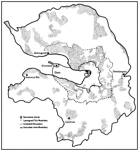
Map 12.
Projected recreational zone and greenbelt in the 1966
general plan, showing the Gulf of Finland dam.
Places," a decision that brought large swaths of the nineteenth-century cityscape under protective measures.[109] The plan also provided for major restoration efforts at satellite palaces and parks in Pushkin, Pavlovsk, Petrodvorets, Lomonosov, and Gatchina.[110] Such concerns would become more pronounced as time passed, with entire proletarian districts from the end of the late nineteenth century coming under preservation scrutiny by the late 1980s.[111]
Improvement of Intraurban Transportation and Communications
The combined emphasis on constructing new districts and maintaining the historic city center necessitated an extensive transportation improvement program. Indeed, transportation problems have emerged as perhaps the most troublesome feature of contemporary Leningrad. Residents have moved away from the central city, but major employment sites, commercial and city services, and tourist attractions are still concentrated in the historic central core. By the early 1980s, one quarter of the pedestrians along the city's main commercial axis—Nevskii Prospekt—were visitors from out of town.[112] Moreover, approximately half of the population of the city's surrounding suburbs worked in the city center.[113] All these nonresidents of the city must rely on public transportation to move about Leningrad's major urbanized areas.
From 1950 until the early 1970s, the number of passengers using the city's public transportation system doubled, the duration of an average trip increasing to approximately 30 minutes.[114] Much of this expansion occurred after the city's subway system opened in 1955, which had a substantial impact on transportation ridership patterns throughout the Leningrad region.[115]
The 1966 general plan provided for an increase in subway and private auto use and projected declining ridership on other transportation systems.[116] Consequently, the plan recommended extensive subway and highway construction programs, as well as development of improved services for the burgeoning Soviet automobile ownership. Despite these efforts, however, highways and auto service facilities have not kept pace with auto ownership.
Development of the City's Scientific Tradition
Although Leningrad's position declined after the transfer of the headquarters of the Academy of Sciences to Moscow in 1934, the city is still a vital scientific center. The 1966 general plan called for further exploitation of such scientific resources.[117] The importance of the local scientific community for Leningrad's economic development will be discussed in greater detail in Chapter 4.
Improvement of Transportation Approaches to the City
The 1966 general plan proposed the construction of new port and airport terminals, as well as the rationalization of rail routes within the city limits.[118] Within a few years these new facilities began to be put into operation. The Moskovskii Station complex was expanded and modernized and plans are under way to phase out the operation of the Varshavskii Station, shifting all passenger traffic to the Baltiiskii Station less than a kilometer away. This consolidation of rail service constitutes a critical development for a city where more than 50 times as many people arrive by rail as by air.[119] Subsequent to the 1966 general plan, a new airport opened south of the city at Pulkovo, and a new passenger port for cruise ships was established at the western end of Vasil'evskii Island.[120]
Satellite Cities, Greenbelts, and Regional Planning
Leningrad planners began to emphasize the need for regional planning approaches during the late 1950s.[121] The plan ratified in 1966 incorporated this regional vision as it sought to govern land-use decisions for some 14,000 square kilometers beyond the city's traditional boundaries, including a 2,590-square-kilometer outer greenbelt free from all development and a 518-square-kilometer inner belt with only limited and strictly controlled use.[122] The plan also urged the full development of satellite centers at Kolpino, Pushkin, Pavlovsk, Gatchina, Petrodvorets, Lomonosov, Sestroretsk, Zelenogorsk, and Petrokrepost'-Kirovsk (see Map 2).[123]
This expansion of city planning to encompass the entire metropolitan area represented a significant innovation in Soviet planning efforts. It was permitted in part by the dominant role in Leningrad of planning agencies of regional-level party institutions that traditionally have sought to integrate the entire region (oblast) under their direct control. This pattern stands in sharp contrast to the situation in Moscow, for example, where city and region remain distinct political and administrative entities. Consequently, the city of Moscow has annexed more and more territory, never quite keeping pace with metropolitan expansion.
More significant, perhaps, was the Leningraders' strategy of planning for metropolitan expansion before development had occurred, thereby channeling growth into desired patterns. The emphasis on greenbelts and satellite cities reflected an awareness among planners of the need to keep ahead of physical growth.
Although planners were unable to stay ahead of the game—in large part because of their striking underestimation of the rate of increase in the region's population—the efficacy of their regional vision became
increasingly apparent with the passage of time. By the late 1970s, several leading economic planning specialists were arguing that the entire Leningrad region—an oblast, please recall, only slightly smaller than Indiana—must be considered as part of a fully integrated unit with the city itself.[124] This conception, as we shall see in a moment, came to form the core of the proposals for the 1986–2000 general plan. It now constitutes a major Leningrad contribution to Soviet urban planning practice and philosophy.
As proposals for the regionalization of planning approaches emerged over the course of the 1970s, the regional party committee took the lead in encouraging integrated plans and, by mid-decade, secured the cooperation of republican and national planning agencies.[125] Again, as we shall see, this development has since transformed all economic and physical planning efforts.
3
Toward a New City Plan, 1966–1986
Leningrad is celebrated as having the highest architectural culture. But for how long must we travel to the historic center for rations of this culture?
—S. P. Zavarikhin, 1986
Aftermath of the 1966 Plan
Any evaluation of the 1966 general plan's impact should begin by noting its calculated optimal population ceiling of 3.5 million residents up to the year 1990. That projection bore little relationship to reality, as Leningrad's population had passed that limit by the time the plan was ratified in Moscow, and it continued to increase, gaining by nearly 1 million residents over the next 15 years.[1] This increase, approximately 70 percent attributable to in-migration, contradicted central policies intended to limit population and economic growth in Leningrad, as well as in other major urban centers such as Moscow and Kiev. The objective of such policies was to force a redistribution of rural population to urban centers spaced more or less evenly across the USSR.[2]
Housing plans encountered immediate difficulty, owing to the pressure of unplanned-for population increases. The plan had specified that only 5 percent of the new housing was to be built within the city's traditional boundaries. As already noted, the remaining 95 percent of projected new housing was to be distributed fairly equally among new districts built to the south, north, and northwest of previously developed neighborhoods. Such spatial projections were designed to alleviate population pressures on the old city center.[3]
While the measures for reducing population densities at the city's center were successful,[4] other creative housing programs in the 1966 general plan faced several obstacles from the start. To begin with, housing construction must conform to central standards, a requirement that helps explain the incredibly monotonous cityscape built up across the USSR in recent years. Leningrad planners sought and sometimes received permission to bypass these norms by designating as experimental—and therefore beyond the reach of centralized construction
| ||||||||||||||||||||
norms—major projects such as the one on Vasil'evskii Island mentioned earlier. Local architects wishing to apply higher design standards also confronted locally generated difficulties. For example, the new industrialized prefabricated construction developed by the Leningrad construction industry ultimately accelerated housing construction, but exacted a high aesthetic price.[5]
Competition among enterprises and municipal agencies for control of local housing and services presented additional difficulties for Leningrad planners, as it did elsewhere in the Soviet Union.[6] Ironically, the Leningrad city soviet controls a far greater percentage of consumer services and housing than do municipal authorities in virtually any other Soviet city, so that the city's government developed many of the new residential superblocks erected over the course of the past 15 years.[7] Instead of alleviating problems of social services' control and coordination, however, this jurisdiction only exacerbated the problems, as municipally controlled land was located at the city's outskirts, far from employment sites and existing service centers. For the most part, services have not moved outward from the city center along with residents (see Table 8).
Unsatiated Demand
In the final analysis, the main housing problem was simply the very heavy demand. The pressures of this unsatiated demand led the best planners and architects to drop many of their most creative designs
in favor of efficiency and speed. The resulting emphasis on the pace of construction compounded long-standing difficulties in coordinating the service sector and residential development in a centrally planned economy. New Leningrad districts were served particularly poorly by consumer, health, educational, and recreational facilities.[8] During the mid-1970s, for example, the city ranked tenth among the 21 Soviet million-plus population metropolitan centers and union-republican capitals in the number of doctors available per capita, and ranked last among these same cities in the number of hospital beds per capita.[9] Concern over inadequate services led some local officials to discuss, and to a limited degree to experiment with, various schemes to place responsibility for developing social and commercial services under the same housing and construction agencies that were responsible for building the new districts in the first place.[10] While the results of these various experiments were never released, they apparently had scant impact, at least beyond the immediate neighborhoods involved. Consumer services in Leningrad remained terribly inadequate throughout the first half of the 1980s. Conceivably, this situation will improve once the small-scale cooperative stores legalized in May 1987 take hold.[11] As with several other Gorbachev-era reforms announced as this volume was going to press, such changes were not yet sufficiently developed to discern an impact. In many ways, such policy initiatives were responses to the futile experimentation of the period under examination here.
The continuing absence of services proved both psychologically detrimental and socially disruptive. Crime became acknowledged as a significant problem, especially where cultural amenities were thought to be deficient.[12] Both officials and the populace grew concerned. A major 1981 survey of popular attitudes toward the quality of urban life found that citizens' ratings of local services and general style of life consistently ranked Leningrad last among the five major cities examined (Moscow, Alma-Ata, Baku, Kiev, and Leningrad).[13]
Urban Sprawl
As might be imagined, the sprawling new residential districts also increased the demand for mass transportation. The city's transit system—particularly its subway—continued to expand rapidly (see Map 13), but the improved facilities failed to keep pace with increasing ridership. This state of affairs was due both to the city's continuing population growth and to the location of new housing construction on the city's outskirts. Meanwhile, other forms of transportation, especially the bus system, failed to meet rising demand.[14]
Local Leningrad authorities have been more successful than most Soviet municipalities in enforcing land-use laws, so that any expansion
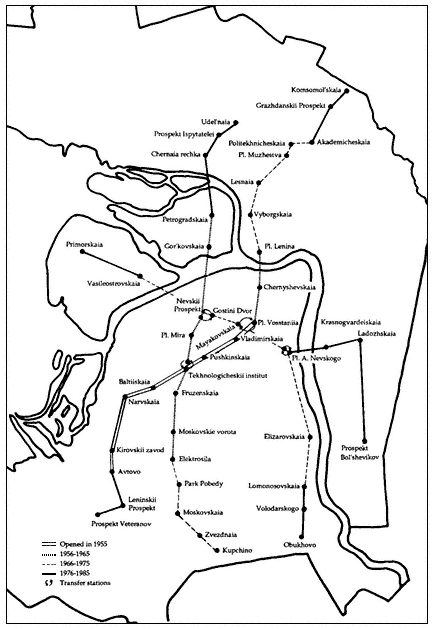
Map 13.
Development of the Leningrad subway, 1955–1985.
of the Leningrad economy came about through more intensive development of already existing facilities, rather than through the construction of new plants.[15] Consequently, employment opportunities were still concentrated in almost precisely the same districts as before 1966, while housing migrated outward. According to one study, the central city population will decline to a half-million residents by the year 2000, while 1.4 million people will be employed by institutions located in the same area.[16] Future city residents will therefore have to travel farther to work, making the commute even longer than the present average of two hours daily.[17] Finally, slow development of service infrastructures in new residential districts required many residents to travel to the city center to shop or meet other obligations.[18]
The pressure on the city's transit system to move people from the periphery into the city center suggests yet another issue: namely, the role of the historic city core in Leningrad's future development.[19] The general plan provided for preservation of the historic center, a goal that has been attained to a remarkable degree. The urban fabric of nineteenth-century Petersburg remains largely intact, helped by the designation of 1,017 structures as architectural monuments, 1,150 as cultural monuments, and 222 as "Lenin Places" to be preserved in honor of the founder of the Soviet state. Few Leningrad planners viewed this marriage of the old city with the new as merely an issue of historic preservation.[20] Instead, discussion of the proper place of the center city in overall regional development also engendered an intense and at times bitter debate over the architectural quality of newer districts.[21]
Environmental Angst
Public concern over the region's natural environment accompanied the concern over Leningrad's man-made environment. The 1966 general plan provided for establishment of a forest-park zone devoted almost exclusively to recreational purposes as well as a suburban greenbelt restricted to carefully controlled development (see Map 13).[22] Both zones have come under tremendous developmental pressure, owing to the region's unpredicted (and therefore unplanned-for) population growth.[23] The inner recreational zone suffers particularly severe strain from overuse by city dwellers who inadvertently tear up fields and forests in pursuit of leisure pleasures. This damage raises questions, for some, of the environmental desirability of maintaining any district solely for recreational purposes.[24]
In addition to general land-use decisions, problems of pollution also must be confronted. Here, as in other industrial societies, solutions are easier to propose than to implement. Many Leningrad municipal officials and industrial managers now appreciate that the nature of pollutants has changed over time, from the biological ones in the pre-
industrial city, through industrial contaminants during the industrial revolution, to the ever more toxic petrochemical pollutants of late-industrial production.[25] In recognition of the problem, local officials at times have supported a variety of coordinated measures that depend on a myriad of institutional actors.[26] Authorities in Moscow and Leningrad have planned to introduce unleaded gasoline at local gas pumps and to launch more aggressive testing programs for automotive exhaust and chimney emissions. Leningrad city planners have recommended removal of the most noxious factories to outlying areas, together with the construction of suburban arterial transportation systems designed to reduce commercial traffic on city streets.[27] Moreover, in 1984, the city undertook preparation of a soil map for a region within a 100-kilometer radius of the city to chart the changing chemical composition of the area's soil, and hence the impact of industrial fallout from the atmosphere.[28] Only a half year later, the city announced a major air-pollution control program.[29]
The paucity of available data prevents us from evaluating the success of these various environmental protection programs. Officially, academic commentators claim that Leningrad's air is less polluted than that of other major Soviet industrial centers. Unofficially, one is told of "black snow" and river water made so warm by chemical pollutants that it will no longer freeze even in the coldest winter. We can hope that the glasnost' (openness) campaign of the Gorbachev administration will make it possible for some meaningful data to be released on the city's air, water, and soil quality. Until such data appear, we must be satisfied to report that various air-pollution control programs are being initiated.
Officials and specialists responsible for protecting Leningrad's environment have voiced concern over the quality of the region's water resources. Local water-pollution control projects have been complicated by the Neva River's relative shallowness and shortness, which limits the natural exchange of stale and fresh water throughout the river and its tributaries. By the end of 1986, local scientists were warning that the region's water resources were threatened by the previously discussed flood-control dam being built across the Gulf of Finland through Kronstadt. According to these reports, the dam would inhibit even further the limited exchange of stale with fresh water that previously had taken place in the river and its tributaries, ensuring that pollution levels would increase and water life would be seriously threatened. Despite continuing protests, these concerns appear to have fallen on deaf ears.[30] At last report, the party's Central Committee moved in March 1987 to expedite completion of the dam and flood-control system, and plans for even more massive new coastal and landfill development on Vasil'evskii Island were being discussed as this volume went to press.[31] It should be noted, however, that municipal
authorities have recently taken some measures to restrict water pollution and now acknowledge the existence of an increasingly severe problem of petrochemical pollution.[32]
Controversy over the dam project refuses to die. Concern about the diversion of scarce resources to the project as well as its potentially negative environmental impact emerged as one of the most emotional issues in the Winter 1989 Leningrad district caucuses to nominate candidates for the Congress of People's Deputies. At one such meeting, Iurii Nikiforov, a Baltiiskii Plant worker and environmental candidate, declared to the voters of Election District no. 47 on Vasil'evskii Island that "Peter I Romanov hacked through a window to Europe, but Grigorii Romanov barricaded it up with a dam."[33] Nikiforov defeated all other candidates that evening but did not make it through the complicated nomination and election procedure to take a seat on the Supreme Soviet.
Specialists also became concerned with uniquely urban forms of "pollution" caused by intense human activity, such as noise pollution and the spread of infectious diseases. Leningrad city officials and their colleagues around the Soviet Union in such cities as Baku have long been aware of the health hazards of intense urban noise levels.[34] Moreover, the city's dank climate makes disease control difficult, encouraging seemingly annual massive influenza outbreaks.[35] Several Leningrad research institutions support programs studying environmental hazards and make recommendations to municipal and industrial leaders concerning environmental protection programs.[36] Finally, a lively academic discussion over the economic costs of environmental deterioration has developed in the national urbanist professional press.[37]
The Lessons of St. Petersburg
Such discussions over the quality of urban life and the city's environment increased after the accession of Mikhail Gorbachev and the initiation of his glasnost campaign. The summer 1986 conference of the 1,550-member Leningrad Division of the RSFSR Union of Architects (the main professional organization for architects) proved especially stormy as delegates excoriated their leadership for past mistakes.[38] In particular, local architects used the forum of the conference to decry what they see as the city's lost qualitative advantage in architectural design construction methods. For example, several delegates pointed to a failure in recent years to develop a sufficient variety of individual apartment unit-types to reflect changing family patterns. The quality of construction of new districts was similarly criticized. Concern was expressed that, unless a higher level of "urban planning culture" was rediscovered in the city, younger architects would lose their motivation to innovate and produce high-quality designs. Most interestingly, the architectural achievements of the city's pre- and postrevolutionary past
were pointed to as possible models for future architectural development.
Just one month later, Leningradskaia panorama published an eloquently biting comparison of historic Petersburg and contemporary Soviet patterns of urban development under the title "Stroll along Prospect Enlightenment."[39] The author, a professional architect, began by recalling an old Russian literary form based on the author or his hero rambling through a given country, city, town, or countryside. By reporting on his impressions, the author is able to share a social critique of the scene under scrutiny. What, queried our contemporary author, would such a literary observer have to say if he were to take just such a stroll through the new districts of contemporary Leningrad? His answer was a withering attack on the visual impact of the neighborhood along Prospect Enlightenment, its substandard quality of construction, and the theoretical underpinnings that led to the design in the first place.
Upon entering the avenue in question, the author tells the reader that an inquisitive reporter would be correct in feeling as if his "soul had been seized." To begin with, the stretch of Prospect Enlightenment in question is almost 200 meters wide. This boundless space could contain within it any of Leningrad's major squares. Unfortunately, the buildings, which were erected during the 1970s, have been placed so that they contribute to the funneling of wind and the acceleration of ground-level wind speeds. Understandably, therefore, our tour leader discovers that a strong wind constantly howls throughout this enormous expanse of open space. Such extravagant use of space is all the more extraordinary when one considers, as the author urges us to, that the traffic needs of the area are served by a two-lane road no more than ten meters wide.
The literary stroll along Prospect Enlightenment continues in this vein at some length, as the author points out various aesthetic and practical difficulties created by the choice of brick color, poorly laid-out internal space of buildings and courtyards, thoughtless landscaping, repetitive use of glass, and the like. Underlying this at times shrill commentary is an explicit belief that architectural design must be freed from dogged adherence to central decrees. Instead, architects are urged to seek inspiration from the historic ensembles of central Leningrad.
Discussions of this sort dominated the local professional press for months following the Union of Architects conference, with ever more strident calls for historic preservation in the center and a learning of the "lessons of Petersburg" by those who design Leningrad's new districts. In November 1986, for example, Stepan Khrulev, chair of the Oktiabr'skii District soviet executive committee, emphasized the need to renovate, reuse, and generally protect the area's aging and substan-
dard housing stock, 98 percent of which was constructed before the 1917 Bolshevik Revolution.[40] This plea was remarkable both for the candid manner in which it set forth the inadequacies of existing housing and for its concern for historic preservation. A month later, Leningradskaia panorama ran yet another article demanding the restoration and reuse of the city's prerevolutionary apartment buildings as the optimal response to the city's housing problems.[41] Here again, aesthetic considerations were among the justifications for rehabilitating existing housing, rather than simply tearing down older buildings to make way for new ones.
An even more authoritative plea for abandoning utilitarian approaches to city building appeared in January 1987 when Boris Ugarov, president of the Leningrad-based USSR Academy of Arts, demanded a perestroika (restructuring) of existing practices in the decorative arts and architecture. Ugarov's views, published in an interview in Leningradskaia panorama, praised the virtues of Petersburg classicism of the late eighteenth and early nineteenth centuries.[42] He spoke kindly of some of the architecture of the early Soviet period as well. However, he strongly denounced the finance-driven approaches to architectural and urban design of the past two decades. Such heartless functionalism, Ugarov contended, deprives the artist and architect of opportunities and destroys the city's unique appearance.
To the Street
Professional architects and even politicians were not the only Leningraders concerned about the limits of modern aesthetics and the inadequacies of current historic preservation efforts. In March 1987, scaffolding went up around two of the city's most historic hotels: the Astoria, from the bar of which John Reed and his fellow Western journalists witnessed much of the revolutions of 1917, and the Angletera where, in room no. 5, the poet Sergei Esenin committed suicide, writing a final verse in his own blood. Immediately following the first appearance of construction materials at each site, the city's morning paper, Leningradskaia pravda , was deluged with phone calls and letters. To quiet the storm, the editors ran a special interview with the city's chief architect, S. I. Sokolov, in which the renovation plans for the two hotels were set forth.[43]
Most of Sokolov's remarks dealt with plans for the more famous Astoria, a style moderne hostelry on St. Isaac's Square now reserved largely for foreigners (see Figure 23). Sokolov promised that the Astoria would be returned to its prerevolutionary magnificence, becoming a monument to the achievements of "the leading masters of Petersburg
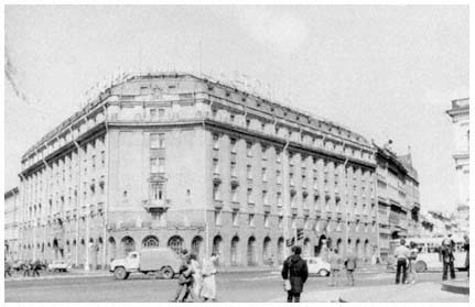
Figure 23.
The Astoria Hotel.
style moderne ." Accordingly, particular attention would be paid to restoring the hotel's facade and major public spaces to their original appearance, while service areas would be rationalized. Individual guest rooms, "several of which do not conform to contemporary levels of comfort," would be upgraded.[44]
Sokolov continued by indicating that the future prospects for the Angletera next door were more complex. The building, located on the corner of Maiorov Prospekt and Gogol' Street in central Leningrad, is much older, having been initially constructed in the 1840s and remodeled many times to suit various purposes. Sokolov noted that it would not, therefore, be possible to restore the Angletera to its original form. Rather, the city's chief architect promised that several major elements of the building's facade would be reconstituted, and some effort would be made to preserve the room in which Esenin died. The vagueness of his statements about the Angletera was emphasized at the close of the interview when Sokolov reported that the Finnish construction firm working on the Astoria site had committed itself to completing its work by August 1989, but gave no indication as to when the Angletera reconstruction would be completed.[45]
Only four days after the appearance of Sokolov's interview—and just days after the erection of construction barriers and scaffolding around both hotels—Leningradskaia pravda reported that hundreds of people had been demonstrating day and night at both sites, carrying placards reading, "Friends, the History of Our City Is Our Root! Save
Our Monuments!"[46] The paper went on to publish conversations with several participants in the increasingly raucous vigil, which had begun on March 18, the day following the Sokolov interview.[47]
Aleksandr Zhuk, an honored architect of the RSFSR and a corresponding member of the Leningrad-based RSFSR Academy of Arts, defended the renovation projects by pointing out that the plans had been developed as early as 1978 at the behest of Intourist, the agency responsible for foreign tourists in the USSR, and had been approved by the USSR Council of Ministers.[48] Zhuk observed further that the buildings had become quite dangerous. Meanwhile, Iurii Andreev, editor in chief of the publication series "Library of the Poet," joined with Zhuk to argue for renovation, pointing out that every effort would be made to preserve those rooms associated with Esenin and to turn them into a special memorial to the poet.[49]
Only days later, however, the influential national literary paper Literaturnaia gazeta recounted the entire incident in an article by Mikhail Chulaki.[50] Chulaki excoriated city officials for their mishandling of the affair, citing extreme heavy-handedness on the part of Chief Architect Sokolov as well as Leningrad city soviet Deputy Chair Boris Surovtsev. Chulaki thought the situation would have been better managed and the fate of the Angletera more secure had Leningrad officials practiced Gorbachevian glasnost.
The ruckus refused to disappear.[51] Weekly demonstrations continued each Saturday morning, sometimes leading to confrontations with the police. Letters continued to pour into the editorial offices of Leningradskaia pravda (and, presumably, to other public agencies) denouncing the insensitivity of Leningrad planners and politicians to their city's cultural heritage.[52] Meanwhile, the Finnish construction crew hired to carry out the job had totally dismantled the Angletera in a matter of weeks.[53]
As time passed, the Leningrad regional and city party committees attempted to assert their control over the situation. Evidently, party leaders moved on two fronts, both of which suggest that the real crime from their point of view was public disorder rather than the destruction of an historic building. On one hand, party agencies began quite early on to lay blame for the incident at the feet of city officials. Party agencies severely criticized city soviet Chair Vladimir Khodyrev, Deputy Chair Boris Surovtsev, and others for their lack of openness in dealing with the public prior to the beginning of demolition and for their clumsy handling of the street demonstrations once public order had broken down.[54] While few commentators seemed to argue that the Angletera could not have been saved (there appears to have been a clear consensus that the building was simply beyond repair), from the party's point of view, those involved with the project should have engaged the public in various review and deliberative sessions before the erection of con-
struction fences and the arrival of the wrecking crews. Within a year, such lessons may have been absorbed, as open discussions between planners and the public over the fate of the city center became more frequent.[55]
On the other hand, the party was not kind to the demonstrators. By some accounts, all students involved in the demonstrations were expelled from their institutions of higher learning (presumably non-student demonstrators suffered some form of punishment at work as well). After a process of negotiation, many students were readmitted, but their "leaders" were not permitted to return to their studies. In a more public vein, the regional party committee observed that, "under conditions of widening democracy," groups, on the whole, "performed patriotic and socially useful roles." Some groups, however, became "characterized by the display of nationalism, Slavophilism, unhealthy temper, and absence of civil maturity."[56] Such tendencies were seen by the regional party committee as manifest in the Angletera demonstrations and were clearly identified as violations of the public good.
Another important postmortem of the affair appeared in the July 1987 issue of Leningradskaia panorama .[57] Some architects contributing to this review reiterated those points made by Chief Architect Sokolov months before.[58] The Astoria, they argued, is one of the finest examples of Petersburg style moderne and is in urgent need of rehabilitation. The proposed plan will return the hotel to its previous splendor. The Angletera, on the other hand, is nearly a century and a half old, was originally constructed for other purposes, has been remodeled over and over again, suffered significant war damage, and simply can not be saved. Nevertheless, the architects involved in the project have worked closely with the Finnish construction crews to ensure that at least the facade will be restored before the construction has been completed. Additionally, the architect-commentators noted, plans for the project had been under consideration for nearly a decade, with relevant articles regularly appearing in professional publications since 1979. Therefore, they suggested, it is simply incorrect to assert that the city's architects have not been mindful of Leningrad's history and of the public interest.
Other commentators took exception to this position, pointing out that contemporary preservation methods, as internationally practiced, would permit restoration of the Angletera facade and interior.[59] If only Leningrad architects and builders were willing and able to practice their craft at the world level, they lamented, the entire issue could have been avoided. As it is, these commentators feared, Leningrad will be left with just another memorial plaque reading not even "In this building. . . ," but only "On this site stood a building in which. . . ."
Finally, some sought to separate questions of public decorum from the various architectural issues under contention.[60] "Youthful maximalism" cannot become the basis for serious professional deliberation,
this argument went. Although buildings of particular merit should be protected and preserved, everyone must recognize that cities are living organisms and must change. The Angletera has little architectural merit and is historically significant only insofar as someone committed suicide there. Therefore, the planners were correct in directing their attention to the more important Astoria. In conclusion, they suggested, professionals should approach complex problems such as those posed by the Astoria-Angletera project in a fully professional manner.
The commentary in Leningradskaia panorama summarizing the positions captures some of the emotion encountered and many of the practical problems raised as Leningrad architects have struggled to come to terms with the rich architectural heritage of their city. Even more important, perhaps, it helps illustrate precisely why the Angletera demonstrations mark an important watershed in public concern for historic preservation in Leningrad. As the opponents to the hotel's destruction stated over and over, what was at stake was the preservation and protection of the city's history and character from the onslaught of modern architecture. Rejection of two decades or more of architectural construction design and planning practices had now moved from the pages of professional journals to the city's streets.
At their core, such critiques of Leningrad and Soviet planning, design and construction practices—like those highlighted by the stroll along Prospect Enlightenment and by the demonstrators on St. Isaac's Square—rested on a shared rejection of modernist planning theories. Leaving aside the fact that construction in Leningrad is of lower quality than in the West, Prospect Enlightenment is not significantly different in conception from Sarcelles outside of Paris or the Southwest Redevelopment Project in Washington, D.C., or other dehumanized urban spaces created during the third quarter of this century. All these projects rest on a "radical" architectural vision that sought to liberate cities and their inhabitants from the tyrannies of bourgeois industrial development. Ironically, they do so through the construction of mass-produced apartment blocks that, by virtue of their size, psychological and physical isolation, and visual monotony, only fragment the social fabric and emphasize the tyranny of the individual over that of the public.[61] A socialist state system explicitly concerned with promoting collective values clings to an urban design philosophy that elevates res privata over res publica , even after architects and planners in various capitalist societies have turned their backs on many of these aspects of the modernist "revolution."
A New Role for an Old Center
The increasingly open calls for a retreat from the architectural and city planning principles of the 1960s and 1970s and movement toward the warm embrace of traditional Leningrad design practices spurred an
intense interest in historical preservation, and continued to do so for quite some time. Preservation efforts captured the public interest in Leningrad, with articles appearing in the daily press, mass magazines, and the professional press. But the actual restoration of historic monuments is only one of many interconnected issues that involve linkages of industrial and residential districts, balancing of service needs, reduction of overcrowding and population densities, and improvement in the distribution of cultural services.[62] Leningrad planners also attempted to improve communication and transportation links between old and new districts.[63] For example, by 1984 the city's streetcar lines, bus and trolleybus routes, and subway lines were carrying approximately 8.5 million passengers each day.[64] Somewhat at odds with standard Soviet practice—and despite the sustained expansion of the city's subway—the lowly streetcar remained a centerpiece of the city's transportation system.[65] In 1985 several existing streetcar routes were changed, and plans were announced for express streetcar routes from new districts to an ever-expanding subway system.[66] The subway system, in turn, had grown by year's end to extend 76 kilometers (about 47 miles), incorporating some 50 stations and carrying 2.3 million passengers on an average day.[67] To improve the distribution of services, Leningrad planners also initiated sociological studies to establish the service, housing, and occupational profiles of residential, commercial, and industrial districts.[68]
While the city's record on historical preservation is world-renowned and continues to attract tourists from around the globe,[69] complex issues like those already discussed have raised questions about the role of the central urban core. With the traditional role of the city center firmly protected by the 1966 general plan, Leningrad officials began to grapple with the problem of maintaining this preserved quarter as a vital and lively district.[70]
To begin with, the city's historic center continued to serve as the region's economic and cultural heart, and this status prevented central Leningrad from becoming a "museum city," despite its rather significant loss of population.[71] Preservation of the city center provided Leningrad's architects and planners with an alternative model of urban development to the one offered by central planning authorities in Moscow.[72] Leningrad's professional publications readily reflected the resulting preoccupation with architectural history and theory, with the psychological impact of physical structures, and with underlying aesthetic values.[73] In February 1985, in a plan designed to accentuate these values, the city announced a major effort to revamp 392 hectares of central Leningrad along and surrounding Nevskii Prospekt.[74] The plan, which was carried out in time for the celebration in 1987 of the seventieth anniversary of the Bolshevik Revolution, called for improving the design of existing commercial facades to bring them more into char-
acter with the avenue's original image. Further proposals advocated turning parts of the Nevskii into traffic-free pedestrian zones.[75] Meanwhile, as we have already noted in the discussion of Prospect Enlightenment, local architects inquired in print why the new districts were not more "cozy." How could the new districts really be called "Leningrad"?[76]
Official Responses
As we have just seen, a number of negative developments were not anticipated by the framers of the 1966 General Plan of Development of Leningrad and the Leningrad Suburban Zone. These include changing population dynamics, housing shortages, consumer service shortfalls, inadequate health care, overcrowded transportation facilities, unsatisfactory architectural aesthetic standards, and environmental deterioration. At varying times, to differing degrees and in different ways and with contrasting levels of success, numerous Leningrad publics—professional and nonprofessional—commented on these continuing urban problems. Local Leningrad authorities have also tried to deal with each of the problems mentioned thus far through official actions. The data supporting the preceding discussion are, after all, drawn almost exclusively from Soviet sources, and for the most part, generated by specialists and politicians in Leningrad itself. Furthermore, the concern of Leningrad's leaders has not been limited to mere recognition of pressing urban problems. They have relied on professional and academic specialists to identify emerging dilemmas; mobilize local resources to cope with such conditions; search the Leningrad past for possible solutions; and, when necessary, turn to central institutions for assistance.
We will now examine how Leningrad officials have sought systematic regulation of a wide range of activities carried out in their community by economic and political actors whose primary allegiance has been to central institutions in Moscow rather than to local institutions in Leningrad. The most important factors determining this process have been (1) the sustained political power of the Leningrad party organization under such national figures as Kirov, Zhdanov, Kozlov, Romanov, Zaikov, and Solov'ev; (2) the sustained presence of a cohesive and unified cohort of professional specialists; and (3) the enduring alternative urban vision of the neoclassical city built by Catherine and her grandsons, praised by turn-of-the-century architectural utopians such as the brothers Benois and Ivan Fomin, and given socialist credibility by Lev Il'in and his students such as Nikolai Baranov.
To explore these relationships further it is helpful to examine four major ways Leningrad officials have reacted to the difficulties encountered, as we noted, in implementing the 1966 general plan: (1) inter-
jection of a social dimension into physical urban planning; (2) a series of limited policy responses to specific emerging problems; (3) regionalization of the local planning process; and (4) initiation of efforts to draft a new general plan, which took effect in 1986. Examining each of these sets of responses in greater detail should shed more light on the complex process whereby Leningrad's leaders modified and adapted public policy objectives to meet local conditions.
Interjection of the Social Dimension
Soviet urban planning encompasses the long-standing conflicts between the two complementary processes of economic planning (planirovanie ) and physical planning (planirovka ). Over the past several decades, both processes have been infused with the tension between the goals of economic institutions controlled by central ministries and those of local municipalities. Leningrad planners have become particularly creative in trying to deal with these fundamental strains in Soviet urban life.[77]
As the discussion in Chapter 6 will indicate, Leningrad's industrial sociologists and labor relations specialists first introduced sociological methodologies into the enterprise planning process as early as the mid-1960s. Linked to growing concern over labor productivity, such socioeconomic planning sought to integrate factory production and social plans. From these early steps there slowly emerged the concept of district, city, and regional socioeconomic planning, whereby the economic plan of a city or region is tied to plans for social, educational, and cultural services. This new interest in socioeconomic planning stimulated considerable research focused on Leningrad, which viewed the urban organization as an integrated whole—a process that created the data base local planners now use for their projections.[78] Accordingly, a good deal of work has been done on developing indices to measure social, productive, and institutional infrastructural change, as well as to assess the general quality of urban life.[79]
These ideas, many of which first emerged in Leningrad, quickly spread to other Soviet planning centers through various conferences, professional publications, and other forums of professional interaction, such as meetings sponsored by the Union of Architects. Indeed, as will be noted in Chapter 6, social scientists and planners in other communities soon contributed, along with their Leningrad colleagues, to the unfolding planning philosophy.[80] For example, during the period of the Tenth Five-Year Plan (1976–1980), Leningrad, Moscow, and Sverdlovsk all had introduced a social dimension into their city five-year economic plans.[81] Finally, in July 1979, city socioeconomic planning received the official stamp of approval of the Communist Party's Central Committee and the USSR Council of Ministers. Both central
political institutions urged implementation of such planning techniques throughout the Soviet Union.[82]
According to resolutions of both bodies, the goals of socioeconomic planning in cities and regions should be (1) the proportional development of the sectorial structure of the local economy (e.g., no single sector should be promoted excessively at the expense of other spheres of economic activity); (2) the "harmonic personality development" of local citizens through improved services (e.g., the service sector, broadly defined, should promote the well-rounded development of the city's residents); (3) enhanced distribution of engineering equipment throughout the urban center (e.g., various technical services, as well as the city's general infrastructural development, should be evenly shared by all districts within the city); and (4) the rational use of material and human resources (e.g., the urban environment should be structured in such a way as to maximize economic efficiency).[83]
Over the course of the 1960s and 1970s, Leningrad's social scientists perfected a model for optimal socioeconomic plans for cities and regions.[84] According to this Leningrad model—which is used as a guideline for planning practices elsewhere[85] —a city's socioeconomic plan will take some 15 years to produce and should include the following eleven sections:
1. A statement of the overall conception of a city's socioeconomic development and its goals for further growth
2. Social characteristics of the city and/or region
3. Scientific development
4. Industrial development
5. Demographic and social development
6. Branch social and engineering infrastructural development
7. Social, "life style," and educational development
8. Protection of society against antisocial influences
9. Development of external and regional economic and social ties
10. Resource utilization and protection
11. Perfection of methods of the administration of territorial economic and social development[86]
Leningraders continued to be leaders in the evolution of these planning techniques at both the factory and the city level. During approximately the past two decades Soviet planning authorities elsewhere have joined in this Leningrad concern for the need for more fully integrated and far-reaching planning approaches. Nevertheless, municipal authorities in the Soviet Union exercise relatively little control over the development of major economic institutions operating within their boundaries, let alone over those in surrounding areas. The Leningrad experience thus continues to stand out not only for its academic so-
phistication, but also for the attention paid to integrated planning by senior political officials, and for, to a considerable extent (at least by Soviet standards), a concern among local municipal agencies for control over the activities of central institutions operating within their jurisdictions. These developments were initiated by responses to inadequacies of the 1966 general plan's population projections, which spurred sociological and demographic research. In short, the relatively successful interjection of a social dimension into Leningrad economic and urban planning emerged as a major response to difficulties encountered in implementing the 1966 city plan. The development of new approaches and their theoretical adaptation in cities throughout the Soviet Union illustrate the manner in which local elites were able to respond to local conditions on the periphery and to alter the planning practices and policies of central elites in Moscow that had previously ignored social considerations.
Limited Planning Responses
In addition to the major restructuring of Soviet urban and economic planning methods, local planners systematically attempted to foster a series of more limited responses to the initial difficulties of implementing the 1966 general plan: for example, control of urban sprawl through increased efforts at "in-filling" (construction of new residential and commercial complexes on vacant land within previously developed districts), promotion of increased population densities, greater attention to renovation, and reduction of the rate of housing construction to allow more care for quality.[87] These diverse efforts will be discussed in the context of a single initiative that embodies many of these somewhat less ambitious planning innovations of Leningrad officials. The proposal for municipal and consumer services in central Leningrad's Dzerzhinskii District put forward by local social scientists and architects illustrates how relatively minor alterations in planning concepts and practices can in time cumulatively cause major changes in accepted approaches to comprehensive urban planning.[88] This more recent plan appears to be moving ahead, in conjunction with an earlier socioeconomic plan for the district discussed later in Chapter 6.
As will be noted in Chapter 6, the Dzerzhinskii District shares unusual problems with the rest of the historic central city (see Map 11). Ninety-seven percent of its housing stock was originally constructed before 1917. Institutions located in the district employ nearly twice as many people as live there. The population is better educated (25.6 percent having higher or specialized secondary degrees, as opposed to a city average of 19.6 percent) and has more younger individuals (students) and older ones (pensioners) than other Leningrad neighborhoods. People also live much closer together in the Dzerzhinskii District
than in Leningrad as a whole (2,300 versus 400 per square kilometer). The district's historic and cultural attractions draw tourists and short-term visitors, who compete with local residents and employees for various consumer services. Finally, whatever the neighborhood's past industrial base may have been, the area is now primarily an educational, scientific, and service district, generating only 0.3 percent of Leningrad's total industrial output.
These rather unusual qualities prompted the proposal of several future socioeconomic developments. The district party committee, acting through its council on economic and social development, cooperated with various planning and academic research institutes located in the district.[89] These agencies developed short-range (5-year), medium-range (10-year), and long-range (20-year) plans for social, economic, and physical development, which were designed to maximize the district's uncommon heritage and to preserve its prominence and vitality. The result included improved recreational facilities (e.g., "vest-pocket" parks and specialized clubs), consumer services (e.g., outdoor cafes), and tourist amenities (e.g., apartment hotels located on the ground floor of residential buildings), intended to guarantee the district's social and economic well-being. The accompanying physical plans assume that the existing urban environment has proven itself to be essentially successful.[90]
Thus, official plan goals came to resemble those less official responses of architects and the public described at the outset of this chapter. Planners now seek to maximize the architectural and environmental potential of the prerevolutionary urban fabric by a variety of measures: for example, incorporating various public conveniences into one courtyard, a cafe into the next, and a small vest-pocket park into a third. This approach recognizes the existing environment as an ideal to be perfected rather than torn down and replaced. Moreover, the plan demonstrates not only a professional capacity to act on the widespread recognition of the failure of central architectural policies, but also a confidence in the ability of local officials to secure sufficient resources to implement their plans. Even on the district level, some Leningrad municipal officials have sufficient maneuvering room and adequate resources for effective responses to local conditions.
Regionalization of Urban Planning
Leningrad has been a pioneer in regional planning throughout the Soviet period, just as it was before. From the days of Peter I and Catherine II, the region's historic integration was fostered by the development of satellite palaces and cities.[91] Kolpino, Kronstadt, and Petrodvorets were all established during Peter's reign, Lomonosov and Pavlovsk during that of Catherine; Pushkin was formally incorporated
in 1808, and Sestroretsk followed in 1917.[92] All these cities were brought together under the jurisdiction of the Leningrad city soviet in December 1931.[93] By the mid-1960s, another two dozen or so communities had similarly been brought under the supervision of the Leningrad city soviet.[94] Then, in 1966, city planners were able to incorporate the entire Leningrad suburban zone into the city's new general plan.[95] Nevertheless, although local elites and common citizens both recognized the presence of a large suburban region around the traditional city limits, few saw these interrelated areas as a single regional urban system , where urban, suburban, and rural areas were locked together as part of a functional unit.
Since the late 1950s, there has been a revolution in the thinking of Soviet urban geographers, economists, and urbanists concerning the nature of the "city."[96] Soviet scholars no longer consider the city merely a large population point. Instead, conventional wisdom has come to define cities as hubs in an agglomeration of settlements linked by various functional subsystems into a unified whole and extending across the length and breadth of the Soviet Union. These views suggest the substantial intellectual impact of the systems approaches of the West on Soviet social science.[97] We will also observe this influence in Chapter 6 when we discuss the emergence of socioeconomic planning. Such procedures combine social and economic subsystems as part of a unified and interrelated system. We can possibly detect an even more pervasive influence of systems analysis in the recent intellectual history of Soviet urban geography.
The ascendancy of systems theory in the body of Soviet thinking about cities can be seen on several different levels. An extensive body of theoretical literature has appeared in recent years describing the systemic nature of Soviet settlement patterns. Since the late 1950s, a number of geographers, including Georgii Lappo, Boris Khorev, David Khodzhaev, and Kazys Seselgis, have pioneered in establishing a distinctively Soviet outlook on urban agglomerations. This literature eventually produced the overarching concept of the Unified Settlement System (Edinaia sistema rasseleniia —ESR) encompassing the entire Soviet Union.[98] Several Leningrad scholars contributed both to the development of that concept and, more generally, to an emerging literature on the city as a system. Indeed, their contribution represents one of the major findings of this study.
At a more practical level, systems approaches to the city have fostered urban planning and management philosophies that seek balanced and harmonious regional development of urban centers in their entirety rather than exclusively promoting the physical development of the central cities.[99] Some authors, such as Leningraders Ivglaf Sigov, Nikolai Agafonov, and Sergei Lavrov, as well as Muscovite Boris Khorev, identify the goal of balanced development as a primary feature
of Soviet settlement theory, thus differentiating it from systems approaches to urbanization emanating from the capitalist West.[100]
Moscow University geographer Khorev was for a long time a particularly prominent Soviet advocate of urban systems theory. He began vociferously to advocate systems approaches during the late 1960s and early 1970s when he first discussed the Unified Settlement System. His volume Problemy gorodov (Problems of Cities ), a work that sought to demonstrate the existence of such a settlement pattern, is still a basic textbook of urban geography in Soviet undergraduate and graduate programs.[101] Khorev elaborated his notions further in more specialized works, among them a coauthored discussion arguing for the necessity of developing an effective demographic policy for the Soviet Union.[102] Khorev defines the balanced and harmonious development of interrelated industrial, transportation, resource utilization, spatial, and social policies as the primary objective of urban and regional planning efforts.
One critical element in conceptualizing the urban system has been the companion notion of the urban hierarchy. Here the Soviet penchant for putting everything in its appropriate hierarchical niche combines with the systems classifications of the West in a steady flow of efforts to assign every Soviet community to some national, republican, regional, or local settlement pyramid. In the Ukraine, for example, Petr Kovalenko has identified a three-tier urban system that is itself a subsystem of the national urban settlement pattern.[103] According to Kovalenko, this Ukrainian subsystem incorporates major population centers (Kiev, Kharkov, Donetsk, Odessa, and L'vov) and large ones (Poltava, Cherkassy, Kherson, and others), as well as medium and small ones, into a unified hierarchy. Kovalenko finds that the republic's major and large urban centers have their own extensive subsystems, with urban agglomerations growing up around such cities as Kiev, Kharkov, Dnepropetrovsk, and Odessa. He then chronicles the various functional subsystems (industrial, commercial, cultural, scientific, and so on) that become integrated through their relationship to the overall urban settlement system. He concludes by arguing that Ukrainian planners should not view the city as merely a population point. Instead, it has become the nexus of a series of multifaceted and multifunctional economic, spatial, and cultural subsystems.[104]
Oleg Litovka has been engaged in a similar study of the Leningrad urban region,[105] identifying several tiers of urban settlements around the first-tier center of Leningrad. For Litovka, Novgorod and Pskov represent second-tier centers linked to the Leningrad agglomeration, while such communities as Vyborg, Luga, and Boksitogorsk are third-tier focal points (see Map 2).
Leningrad social scientists have made significant contributions to new conceptualizations of the "city." These include the general theo-
retical works of such geographers and economists as Nikolai Agafonov, Evgenii Murav'ev, Sergei Uspenskii, Oleg Litovka, and Marat Mezhevich, which examine the methodological problems of investigating socialist settlement patterns. Much of this work has been based on studies of the Leningrad region.[106] One practical result of such academic endeavors has been to persuade planners that the Leningrad agglomeration in fact includes the entire area within 90 minutes' commuting time from the city center by rail, and not just those areas traditionally considered to be part of the metropolitan region or subordinate to the city soviet.[107]
The widespread acceptance of systems approaches to urban settlement patterns drastically altered Soviet urban planning practices in general and Leningrad planning approaches in particular. The central focus of planners shifted from the specific structural environment of a given urban area to the interaction of that region with its surrounding communities through, various demographic, economic, spatial, transportation, communication, cultural, and environmental subsystems. This movement from a static architectural view to a dynamic systems view of the planning process marked a significant departure from traditional Soviet urban planning and managerial strategies.
In the case of Leningrad, the transformation meant that city administrators no longer saw their city merely as the urban system that was in place at the time of Alexander I. Instead they have accepted the vision of a "Leningrad" that comprises an extensive interlocking network of central, suburban, and exurban districts, many but not all of which are now under the jurisdiction of the Leningrad city soviet—rather than the regional soviet—and all within a relatively well-defined commuting radius of the city center.
The consequences of such a metamorphosis have been substantial. While the city's boundaries and direct authority were not extended outward, regional state and party agencies came to provide an integrating mechanism for the entire metropolitan region. In recreational design, for example, a new spectrum of nonurban facilities has fallen within the range of options open to Leningrad planners.[108] Similarly, industrial location policies are no longer limited by old geographic boundaries; nor, for that matter, are capital investment strategies.[109] Finally, planners have begun to consider the removal of entire urban functions from the central city to self-contained settlements on the periphery. In this last regard, Leningrad architects developed plans for self-contained academic communities, to the southwest of the city near Petrodvorets for the new campus of Leningrad State University, and to the north at Shuvalovo for the new complex of the USSR Academy of Sciences' Leningrad Scientific Center.[110]
In addition to expressing academic theories and planners' visions, expansion of the concept of the city and region conformed closely to
long-standing political and institutional arrangements. Throughout the postwar period, regional institutions and officials have dominated the Leningrad Communist Party organization. Consequently, institutional and political frameworks to support regional urban management approaches were already in place long before the 1970s. Since urban management and planning decisions had previously been made on a scale larger than the boundaries of the central city and adjacent suburbs, regional political elites probably viewed the new planning approaches as the logical extension of existing institutional patterns.[111]
By the 1970s, then, the same factors that will be mentioned in our next policy studies (academic expertise, enlightened administrative responses, and regional political custom) produced an innovative response to inadequacies in public policy implementation—in this case, inadequacies in the 1966 general plan. The plan's static architectural nature and its relatively confined geographic scope came to be widely rejected in Leningrad and elsewhere.[112] As in the other policy areas, Leningrad scholars, managers, and politicians were ahead of their colleagues, their inventiveness taking the form of a series of proposals incorporating the entire oblast into a new Leningrad general plan.[113]
Proposals for a New General Plan
By the mid-1970s, it had become obvious that the 1966 general plan was giving little guidance for the future development of the Leningrad urban system. Before the decade's end, the local branches of the Soviet Sociological Association (the professional organization for sociologists) and the Union of Architects had organized and published the results of a major multidisciplinary conference focused on the city's future development until the year 2000.[114] The discussions provide ample evidence that local party, municipal, and planning authorities, along with professional architects, designers, and social scientists, all recognized the obsolescence of the 1966 plan. Initial proposals for a new plan began to be circulated.
As a new decade began, references in the professional press indicated that a new general plan would become effective as early as 1984.[115] Since the actual planning process and documents are classified as secret—and public discussion of their content, as well as informal discussion with foreigners, constitutes an illegal activity—we can only speculate about the process on the basis of a limited public record. The primary objective of all of these recommendations appears to have been the incorporation into a comprehensive document of social and economic components, along with more traditional physical planning targets. As a major factor in the proposed expansion in the scope of architectural planning, advocates of new strategies pointed to the in-
ability of city administrators to adjust physical planning goals to changing social and economic realities.
Preparing a new general plan of development for an urban community as large and complex as Leningrad has become a mammoth undertaking, made even more complicated, of course, by the classified nature of the process. In the Soviet context, plan drafters initially consult with economic leaders to produce a statement of the region's long-term economic priorities. Such economic objectives are then established in an unpublished document, the "technical-economic foundations" (tekhniko-ekonomicheskie osnovy —TEO) for the future planning project. Next, architects and physical planners develop a detailed strategy to transform these economic objectives into construction and architectural design programs. The documents prepared for this second planning stage then become the basis for the proposed new general plan.[116]
A close reading of Leningrad's leading daily newspapers, Leningradskaia pravda and Vechernyi Leningrad , indicates that preparation of the new general plan moved forward with deliberate speed. In September 1983, a meeting of the city soviet executive committee's main architectural-planning administration convened to examine the status of the draft general plan's technical-economic foundations.[117] Reports published following that session indicated that the effective date for the new plan was postponed from 1984 to 1985 and that the overall planning orientation was still the city and its suburban zone. Participants expressed particular concern over the need to control urban sprawl through in-filling projects, as well as over the importance of developing more comprehensive transportation forecasts in general and subway ridership projections in particular. The following month, preparations for the new plan were discussed at a meeting of the executive committee of the Leningrad regional soviet.[118] Public reference was made at this point, and for the first time, to the possibility of expanding the general plan's scope beyond the 521-square-mile immediate Leningrad metropolitan area to incorporate projections for the Leningrad region as a whole.
In early 1984, regional party First Secretary Lev Zaikov informed delegates to the twenty-sixth Leningrad regional party conference that initial draft documents for a comprehensive regional general plan would appear before year's end.[119] By April, Zaikov was reporting further that Communist Party General Secretary Konstantin Chernenko had congratulated Leningrad officials on their preparation of a new general plan.[120] Despite all these references, no clear image of the nature of the new plan had been enunciated prior to the summary report of a session of the regional party committee in June 1984.[121] In discussions at that meeting, regional party committee members observed that the
executive committees of the city and regional soviets were preparing a unified general plan for both jurisdictions.
These efforts drew on the expertise of several departments of regional, city, and district party committees throughout the oblast, as well as the planning commissions of regional and city soviet executive committees, the main architectural-planning administrations of those same institutions, the Northwestern Branch of the RSFSR State Planning Committee's (Gosplan RSFSR's) Central Scientific-Research Economics Institute, the USSR Academy of Sciences' Institute of Socioeconomic Planning, local design institutions, and several other major organizations in design, architecture, and construction.[122] The projected plan sought to define regional development for the period 1986–2005, and would be issued in two stages. First, the draft technical-economic foundations would appear prior to December 1, 1984. Next, the draft general plan would be released for discussion before November 1, 1985. Then, the final plan documents would be ratified by the appropriate local and central agencies and put into effect prior to 1986.
Shortly thereafter, the city party committee secretary, Anatolii Fateev, reported to his committee that the proposed general plan would be the first project of its kind in Soviet history to integrate both city and regional planning processes.[123] Further evidence of the genuinely regional approach adopted by plan framers may be found in the September 1984 issue of the local architectural community's professional journal, Leningradskaia panorama , in which Iurii Baranov, the chairman of the Boksitogorsk city soviet executive committee, reported on his city's participation in the preparation of the new regional general plan.[124]
Leningradskaia pravda and Vechernyi Leningrad summarized yet another session of the Leningrad city council executive committee's main architectural administration in November 1984.[125] The papers' reports of the meeting noted that nearly every Leningrad political or economic official of any consequence, including the entire regional and city party committees' bureaus, convened in joint session with the main architectural-planning administration to discuss the "Technical-Economic Foundations of the Unified General Plan of Development of Leningrad and the Leningrad Region in 1986–2005." Regional party First Secretary Zaikov and city Chief Architect Gennadii Buldakov were among the most prominent officials to address the gathering. The rather brief communiqué nonetheless offered one of the most comprehensive statements concerning the contents of the new general plan's technical-economic foundations that had yet appeared in the Soviet press. Even in this truncated form, the articles made it clear that the new 1986 plan was based on extreme concern over labor shortages and would therefore stress technological innovation, increased economic specialization, and
regional integration. This statement of goals was reinforced when the entire city soviet executive committee ratified the plan's technical-economic foundations the following January.[126]
In the spring of 1985, Mikhail Gorbachev toured Leningrad and gave his blessing to the draft 1986 general plan.[127] A few weeks later, in early June, the Central Committee's Politburo also approved the document, thereby paving the way for public discussion of plan details.[128] The day after the Politburo's action, planning commission Chairman Kazimir Labetskii, in a front-page interview with Leningradskaia Pravda , revealed that the plan's primary objectives included more balanced regional development; technological intensification of the Leningrad economy; greater efficiency in the use of water, energy, and heating; strengthened environmental protection; and improved services for transportation, health care, child care, housing, and consumers.[129] Housing and service facilities would also expand, thereby improving the region's quality of urban life.
The proposed integration of regional and city planning, Labetskii continued, would end the disproportionate concentration of the region's productive capacity in the city of Leningrad. The more balanced approach to the regional economy would be achieved by reducing the number of workplaces in the city, while local labor productivity and aggregate production would be increased by stepped-up programs of technological innovation. Labetskii's portrayal of the draft plan was echoed in Iurii Solov'ev's initial appearances as regional party committee first secretary.[130]
Next, in October 1985, Leningrad's chief architect, Gennadii Buldakov, and the chief of the general planning process, Valentin Nazarov, coauthored a lead article in the journal Leningradskaia panorama spelling out the overall goals and parameters of the new general plan.[131] According to Buldakov and Nazarov, the plan was based on the previously mentioned technical-economic fundamentals approved by the Politburo earlier in the year. Covering the period 1986–2005, the new plan sought (1) intensive development of the local economy; (2) improvements in the city's consumer services, water supply, energy and heating systems, and transportation network; and (3) enhanced environmental protection measures.
The 1986 General Plan
The editors of Leningradskaia panorama devoted the better part of their July 1986 issue to a summary of the 1986 general plan.[132] This report provided the most publicly available detailed description of what is contained in the final (and still classified) plan documents approved by various regional governing bodies in late 1985.[133] Significantly, even
this overview of the 1986 general plan provides insufficient information for meaningful public participation in the planning process. Furthermore, it appeared only after the plan had been approved in Leningrad as well as in Moscow.
According to these articles, the 1986 plan represented a major departure from previous practices in that it included provisions for the entire Leningrad oblast.[134] This observation confirmed the previous evidence—noted earlier—that local planners had expanded the conception of the urban planning process to extend well beyond the boundaries of the city and its extensive surroundings to encompass much of Leningrad's hinterland. It also represented a strengthening of the general plan by bringing it into closer conformity with economic planning procedures, since the five-year economic plans governing Leningrad's economy are for the most part developed on a regionwide basis.[135]
The journal's editors also chided the drafters of previous Leningrad plans for not being sufficiently concerned with economic and social factors.[136] The 1986 general plan, they continued, placed prime importance on such broad social and economic contexts of urban development as the size and character of the existing workforce and the measures taken to support regional integration of science and industry. In this manner, the articles appearing in the July 1986 issue of Leningradskaia panorama confirmed the prominence of the various socioeconomic planning and managerial techniques that will be discussed in Part 2.
Science Dominates
Beyond these general observations, the articles focused on some of the more important provisions of the new general plan. At this point, the journal praised the "Intensification-90" campaign (to be discussed in Chapter 4) for its vision of a technology-dominated Leningrad economy by the turn of the century.[137] More specifically, the new plan called for the elimination of several smaller enterprises and the creation of a more limited number of larger and fully automated shops, assembly lines, and plants. In this manner, the previously mentioned trend toward increased concentration of the region's productive capacity in fewer and fewer institutions promised to continue.
In language that echoed the proclamations of Frol' Kozlov some three decades before, the journal's editors declared that the shift to a more scientific economic base would be accompanied by increased reliance on such sectors as machine construction, energy, shipbuilding, instrument making, electronics, and computers.[138] Infrastructural, housing, and cultural developments would be dominated by concern for the needs of these economic sectors.
Regional Integration
In preparing the new general plan, Leningrad officials concluded that labor shortages remained the fundamental factor limiting economic development in their region.[139] The plan endorsed regional integration as one means for reducing the negative impact of such shortages through improved resource allocation. In this regard, planners pointed out that 75 percent of the oblast's population lived in the immediate Leningrad metropolitan area, as opposed to 57 percent of the inhabitants of the Moscow oblast residing in metropolitan Moscow, 56 percent of the population of the Kiev oblast living in Kiev, and only 27 percent of the residents of the Sverdlovsk oblast living in and around the city of Sverdlovsk.[140] The Leningrad planners saw this concentration as restricting the possibilities for flexible regional growth strategies. Therefore, they sought to limit the metropolitan area's population growth over the next two decades to a ceiling of 5 million, with any additional population expansion being pushed off to the eastern areas of the Leningrad region.[141] To achieve this goal, the plan proposed to reduce the city's labor force from 945,000 in 1985 to 890,000 in 2005, while simultaneously increasing the population and housing stock of districts lying beyond the Leningrad metropolitan area.[142]
Despite the professed desire to expand economic activity outside the city, planners continued to view Leningrad itself as the focal point for the entire region.[143] The Leningrad neoclassical architectural tradition continued to be valued for providing both a blueprint for the restoration of existing structures and a set of principles that should govern the planning and construction of new areas.
Overall, the plan distinguished among six different urban zones within Leningrad (see Map 14):[144]
1. A central zone (including such areas as Kronverk, the point of Vasilev'skii Island, and the Admiralty district), which would retain some population while serving primarily as an architectural and cultural museum
2. A middle urban zone (stretching along Nevskii Prospekt roughly from the Fontanka River to the Moskovskii Station and in analogous areas elsewhere in the city), which would be subject to strict preservation regulations while continuing to have a multifunctional character
3. A zone of secondary urban development encompassing both green areas (such as those on Elagin Island and in the Smolenskii cemetery and Aleksandro-Nevskaia monastery) and mixed residential-commercial areas (such as are found in the Smol'ninskii District)
4. An industrial/residential zone (such as those areas on Krestovskii Island, in the Sovetskaia street system, and near the
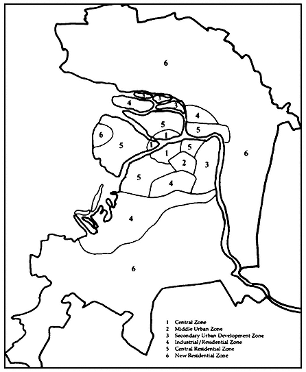
Map 14.
Major urban zones in the 1986 general plan.
technological institute), which would become the focus of efforts to modernize production facilities and to impose more stringent ecological controls
5. A central residential zone (including much of Petrogradskaia Storona, Dekabristov Island, and Aptekarskii Island), which would be home to large-scale industrial and scientific establishments, in addition to residential areas, smaller institutions in the area having been removed to create more open space
6. A new residential zone (including the west bank of the Neva and newer districts in outlying areas), which would remain residential in character while requiring significant reconstruction of apartment complexes built during the Stalin and Khrushchev eras, as well as the imposition of more stringent environmental controls to prevent future overdevelopment
Differentiated Development Strategies
To achieve the distinctive goals established for each of these zones, three different preservation/development strategies would be employed. First, the central city essentially would be preserved in its entirety. Second, the new residential zone would be subject to the "Moscow" approach, whereby all but the most significant structures are replaced. Third, the remaining areas would be developed according to the "Leningrad" strategy by making optimal use of existing structures, remodeling internal space to preserve facades whenever possible, and expanding open space while permitting new development that will not violate the essential character of a given district. This third strategy was thought to be the most expensive as it placed greatest demand on capital construction funds.[145] As the plan was for the entire Leningrad region and not just for the city and its metropolitan area, equivalent strategies were formulated for agricultural areas, as well as for the towns and cities spread out across the oblast beyond the immediate Leningrad area (such as Luga, Lodeinoe Pole, Priozersk, and Vyborg).[146]
Social Infrastructure
In addition to architectural and economic concerns, the new general plan was said to pay significant attention to the region's social infrastructure, including provisions for expanded facilities for education and health care.[147] In keeping with the regional thrust of the new plan, health care and cultural facilities were to be concentrated as much as possible away from central Leningrad. Moreover, the policy of relocating major scientific and higher education facilities in the city's suburbs (e.g., the move of Leningrad State University to Petrodvorets and that of the USSR Academy of Sciences' Leningrad Scientific Center
to Shuvalovo) was to continue. These shifts were to be facilitated by transportation and infrastructural development policies (canals, energy lines, and the like) that emphasized regional interdependence.[148]
Environmental Choice
In keeping with the various responses to the insufficiencies of the 1966 general plan, over the next two decades greater attention was to be paid to environmental concerns.[149] In particular, the movement of population outward from Leningrad was to be channeled away from environmentally vulnerable areas. Furthermore, in response to intense criticism of environmental degradation, special efforts were to be made to free Lake Ladoga, the central source of fresh water in the area, from industrial pollution by 1995.[150] This last goal would be of considerable import for the city, given its location in the delta of a river, the Neva, fed by waters from the lake.
Learning from the Past
Many of these provisions of the 1986 general plan were in keeping with the nature of the popular, specialist, and political discussion of the various inadequacies of the 1966 general plan described at the outset of this chapter. It appears, then, that the new planning document was a product of several years of probing, experimentation, and debate. Furthermore, the explanations of plan objectives that have appeared in various public forums (e.g.. the print media, lectures, television, and radio) are less reticent in commenting on the plan's potential limitations than was the case in 1966.[151] For example, local specialists are skeptical of the ability of local institutions to exert authority over the activities of the ministries within their jurisdictions.[152] This new-found public appreciation of the difficulties inherent in bringing to life provisions of a city plan, plus the considerable degree to which those provisions have drawn on the shortcomings of previous plans, suggests that many of those charged with regulating Leningrad's urban environment have attempted to learn from the past.
At the most general level, then, the new general plan identifies highly specialized, technologically intensive industries as the core of all future regional development. Furthermore, the plan's technical-economic foundations emphasize the importance of increased specialization throughout the regional economy. The plan document also apparently contains several specific recommendations to reconstruct and retool the region's operating industrial plant.
As a logical consequence of this orientation toward development, the plan stresses the primacy of workforce needs. In fact, as we will
see in Part 2, the draft document interjects into the physical planning process the same social variables that were developed some 15 years earlier in response to industrial planning needs during the emergence of socioeconomic planning methods. Capital investment and construction plans in the physical planning protocols will reflect the same over-arching economic priorities.
The new general plan focuses on integrated regional economic-social-infrastructural development.[153] The technical-economic foundations single out energy and transportation resources for special attention. Beyond the confines of the immediate urban agglomeration, the plan pays particular attention to long-term land reclamation projects, as well as to the vital role of the forestry and woodworking industries. Furthermore, the plan enunciates strategies for improving local living standards, and includes programs for service, health, cultural, and housing infrastructural development.
The heavy emphasis on both regional planning and balanced development reflects the strong intellectual influence of Western systems approaches on contemporary Soviet urban geographers. The sweeping pronouncements on living standards and urban infrastructural development are evidence of the extensive planning innovations of Leningrad urbanists over the past two decades. Those same pronouncements offer indirect testimony to the continuing symbolism of the traditional central city as an effective model of urban development. The incorporation of a social and an economic dimension into the physical planning process testifies to the long-term significance of the original socioeconomic planning experiments of the 1960s. To understand precisely how this is so, we now need to direct our attention to efforts to plan and manage Leningrad's socioeconomic environment.