11—
Sunset Cliffs and Point Loma
Description of the Area
The community of Ocean Beach extends south into Sunset Cliffs, a residential area in the city of San Diego at the north end of Point Loma. The northern part of Ocean Beach is laid out on a remnant of the old delta deposit of the San Diego River plus sand dunes (fig. 89). Historically, the beach in this area was subject to periods of accretion following floods. Since the building of the San Diego River jetties, the beach has had to be maintained by the spoil from dredging.
South of Ocean Beach the coast rises, consisting of Cretaceous and Pleistocene sedimentary formations, forming the scenic Sunset Cliffs area of Point Loma. The point itself rises to a height of about 400 feet, with steep sides at the southern end. The structure of this area, which forms a counterpart to Soledad Mountain, is described by Kennedy (1975a , 1975b ).
Rapid Erosion of Sunset Cliffs in Recent Years
It was noted by Kennedy (1973) that sea cliff retreat at Sunset Cliffs amounted to three feet in the last seventy-five years, or about two inches per year. Where a cave roof collapsed, however, local retreat could be much greater. In recent years, rapid retreat has endangered the road along the cliff, necessitating the dumping of concrete debris at several locations (fig. 90). Unfortunately, the debris has actually accelerated erosion by grinding away at the cliff face, aided by the wave action throwing the coarser material against the cliffs, as shown in our study at Oceanside (Kuhn and Shepard 1980).
As evidenced from examination of photographs taken in 1938, 1946, and again in 1968 (figs. 91a , 91b , 91c ), originally there was an offshore arch and another attached to the cliff. By 1945, the longshore arch had collapsed, and the offshore arch was well developed. In 1968, only a small pedestal remained of the offshore arch, and the isolated rock near the former cliff arch had completely disappeared. Also, a large quantity of concrete and asphalt debris had been dumped down the cliff to retard further erosion.
In recent years, the U. S. Army Corps of Engineers (1976) investigated the coastal retreat at Sunset Cliffs and determined that as much as thirty-eight feet of landward retreat occurred at the toe at Del Mar Street and forty feet along the top of the bluff (fig. 92). The majority of the erosion at this site is the result of surface runoff, overwatering of the bluff top, pedestrian traffic, and burrowing by animals. Erosion has occurred in many places as far back as the coastal road, and city authorities have dumped concrete debris and asphalt at these locations in an attempt to slow erosion. In March 1968, a section of Sunset Cliffs separated from the cliff and slumped as a result of an earthquake, and the coast road was endangered (fig. 93).
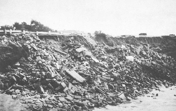
Figure 90
View of erosion along Sunset Cliffs, Point Loma, 1980. Note that large amounts of concrete debris have been
dumped along the area to slow erosion of the cliffs and the adjacent road.
Photo : G. Kuhn.
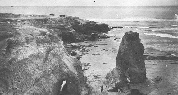
Figure 91a
View of sea arches at Sunset Cliffs, 1938. Note that one arch is formed in the center of a sea stack and the
other is connected to the mainland cliff.
Photo : F. Shepard.
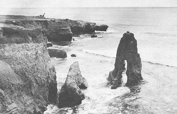
Figure 91b
View of the same site as that in 91 a , 1946. Note that the arch previously connected to the mainland has collapsed.
Photo : F. Shepard.
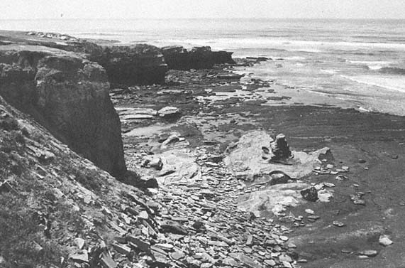
Figure 91c
View of the same site as that in 91 a and 91b , 1968. Note that only a small pedestal remains to mark the
site of the arch. The isolated rock near the cliff has also disappeared.
Photo : F. Shepard.
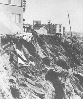
Figure 92
View looking south along the bluffs at Del Mar Street,
Sunset Cliffs, 1976. A line indicates 1954 property
line. The bluff top retreated forty feet, and the cliff
base retreated thirty-eight feet between 1962 and
1976. From 1952 to 1976, the total retreat at the top
of the bluff was approximately seventy-five feet.
Photo : D. Pain.
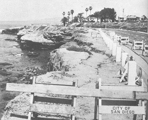
Figure 93
Slumping as a result of an earthquake at Sunset Cliffs, endangering the coastal road.
Photo : F. Shepard.
Ballast Point
What is now Ballast Point was originally named Punta de los Guijarros, or Cobblestone Point, by the early Spanish explorers. The stones found there were a natural phenomenon. Because this area, on the east side of Point Loma, was an obstacle to entering the bay, it was a favorite place to dump ballast while the ships waited for sailing tide, and hence the name change. The point was originally fortified as a military defense for the harbor and the city of San Diego. In 1847, however, all but one cannon from the fort located on the point were dismantled and thrown into the deepest part of the bay. The point was later utilized by whalers, and thousands of whales, killed in nearby waters, were processed at this location. In fact, the first smog in the area was created from the whale-oil smoke. The smog finally disappeared when the whale population in the area was sufficiently reduced so that the whaling operation was no longer profitable. Guns were installed again in 1873 but were not fully operational until the 1890s. One wonders what nation might have attacked us at that time. Since then, the Navy has continued various operations at Ballast Point and elsewhere on Point Loma.
The sedimentary formations near the lighthouse at the southern, outer end of Point Loma contain some boulders with dimensions of up to twenty feet, consisting of metamorphosed volcanic rock completely foreign to the area. This is a most difficult occurrence for geologists to explain because no well-known method for transporting such large boulders seems to apply. It is obvious that there were no icebergs or glaciers at the time which could explain the placement of these foreign rocks. It has been suggested that faulting, and landslides resulting from the faults, might have produced the phenomenon, but no such faults have been found. Another possibility is that there were great slides on the sea floor, as are occasionally seen in submarine canyons, which might have carried the boulders for miles from the crystalline rock zone to where they are now found. We are finding that great displacements are possible on the sea floor, although we do not totally understand their mechanism.
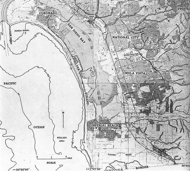
Figure 94
Location map of Coronado and Imperial Beach south to the Mexican border.