The Impact of Transportation
In encouraging the outward movement of families who seek space, status, good schools, and accessible governments, transportation has played a crucial role in the New York region as in other urban areas. Commuter railroads fostered the region's early suburbs; and the massive postwar decentralization of the region was made possible by widespread automobile ownership and the development of the nation's most extensive urban highway system, composed of over 1,500 miles of limited access expressways, parkways, and turnpikes, as well as over 5,000 arterial highways. By freeing the region's development from the constraints imposed by the fixed-rail systems, the automobile and the highway opened up vast new territories for development and "made possible a more lavish use of the land by adding so much to the urban supply."[22]
The scale of the New York region, its immense central business district, and the extensive rail network produced considerable suburbanization before the advent of the automobile. Located primarily in the inner ring along the commuter rail lines that radiate out from the core, most of these older suburbs were settled in the late nineteenth century and first three decades of the twentieth century. Their development patterns were strongly influenced by the rail system. Since most of their residents wanted to be within walking distance of the station, land use was fairly intensive in suburbs like Great Neck on the Long Island Rail Road, Larchmont on the New Haven, Scarsdale on the New York Central, Ridgewood on the Erie, and Montclair on the Lackawanna.
Large homes on relatively small lots predominate in these and a score of similar communities, together with extensive apartment house development in the vicinity of some local stations. Most of the commuters who originally settled in these communities had white-collar jobs in the CBD and above-average incomes. With their superior school systems, spacious and expensive housing, high social status, and relative proximity to Manhattan, many of the older suburbs have continued to attract upper-income CBD executives and professionals. Others in the higher-income levels have exchanged the convenience of the close-in commuter rail towns for the more spacious exurbs of the intermediate and outer rings. Although the ride is longer and the plots considerably larger, suburbs like Pound Ridge, Westport, Rumson, and Bernardsville have been almost as dependent on the commuter railroads for their development as the older suburbs.
The new suburbs of the automobile age differ in several important respects from the older suburban communities along the commuter rail lines. Initial development in the postwar towns has been almost exclusively in single-family homes. In Suffolk and Monmouth, two of the suburban counties that grew most rapidly, 95 percent of the housing built during the 1960s was
[21] Vernon, Metropolis 1985, p. 191.
[22] Ibid., p. 199.
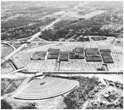
Shopping malls proliferated in the region's suburbs
throughout the 1960s and 1970s, typically at the
intersection of major highways, as in the case of the
Garden State Plaza in Paramus, New Jersey.
Credit: Louis B. Schlivek, Regional Plan Association
single-family. In the newer suburbs, lots have been a good deal larger, with correspondingly lower residential densities than those found in the suburban areas settled before World War II.
Unlike the pioneer suburbanire who generally commuted to the CBD, most of the residents of the new automobile-oriented suburbs work outside Manhattan. Between 1950 and 1970, the number of employed people in the outlying counties increased by 500,000, but less than 100,000 new commuters were added to the CBD work force during the same period. Relatively few residents of the new suburbs use public transportation for their journey to work, or for any other travel. Another contrast with the older suburbs is the much higher proportion of working-class residents. Upwards of 40 percent of the residents of the postwar suburbs are blue-collar workers, almost all of whom drive to their jobs. These people live in what the Regional Plan Association calls "spread city," a rapidly growing area encompassing the outer reaches of the region's inner ring and everything beyond in which residences, stores, factories, schools, churches, roads, and every other facility requires more and more space.
Speaking of this rubber-borne revolution, Louis Schlivek notes that it is "changing the face of the region more rapidly and extensively than any other phenomenon in three hundred years of history."[23] In 1950, there were fewer than 2,000 residents in Plainview, a truck farm community astride the path of the Long Island Expressway on the Nassau-Suffolk line. By 1960, almost 28,000 people lived in Plainview, which also acquired shopping centers, industrial parks with ninety-five industrial facilities employing 7,000 people, and a phalanx of restaurants and hotels along the expressway. The transformation of Waldwick in northwestern Bergen County also is typical. Waldwick had less than 3,000 residents when the developers arrived in 1946. Fourteen years later, 10,500 people lived in the community, 44 percent of whom were of school age. Between 1950 and 1960, school enrollment increased 500 percent, requiring 1,340 new places in the borough's elementary schools, the construction of a new high school, and a threefold increase in local taxes. Elsewhere along the region's rapidly advancing frontier, the story was similar as people and automobiles combined to produce explosive growth.
The new suburbs' low residential densities mean that almost everyone lives beyond walking distance of stores, schools, churches, commuter railroad stations, and bus stops. In addition, an increasing proportion of the new suburbs' residents work outside the core; for most there is no alternative to the automobile even if they sought one. Thus, the average suburbanite portrayed in a recent Nassau County advertisement was not the stereotyped CBD-bound commuter, but "the man who works minutes from home," who "gets into his car in the morning to drive the few miles to work."
These developments, as the Port Authority points out, have produced a "pattern of regional travel [that] is becoming more diffuse, less distinct. More points of origin are becoming linked with more points of destination, but the links do not form any continuous linear arrangement. Travel paths are growing in number and channelization is being eroded by dispersal. The opportunities for group travel diminish, the demands for individual travel increase."[24] The result has been a phenomenal increase in automobile use in the newer suburbs. Morris and Suffolk counties have more than 1.5 autos per household, compared with one for every two households in Brooklyn and one for every four in Manhattan. Despite the heavy use of mass transportation, the automobile accounts for two-thirds of the weekday trips made in the region's intensively developed 3,600 square miles. Because of the growing diffusion of origins and destinations in the new suburbs, the focus of highway development shifted in the 1960s from radial to circumferential roads.[25]