9—
NATIONAL AND REGIONAL RIPARIAN TRENDS
TOWARD A BROADER PERSPECTIVE
California Riparian Systems
A Renewable Resource Awaiting Renewal[1]
Huey D. Johnson[2]
Looking through the agenda of this conference I see a preponderance of papers reviewing the technical aspects of riparian systems. I charge that you may not be able to see the riparian forest in your enthusiasm for studying the individual trees. I am afraid if special care is not taken, this conference will be a funeral for the last vestiges of our once extensive riparian areas, instead of a rededication to the importance of preserving and enhancing our limited and constantly diminishing riparian resources.
Should the doctor spend his time studying a dying patient's condition, or should he concentrate on curing the disease and saving the patient's life? The answer is clear.
Our riparian systems are not merely sick or degraded, they are virtually destroyed. The systems did not cause their own destruction. Man caused the destruction through poor resource management unduly influenced by politics, policies, and economics. We can maintain and restore these systems using the same forces that helped in their destruction—enlightened politics, and forward-looking management policies which recognize cost:benefit ratios favoring natural systems and renewable resources.
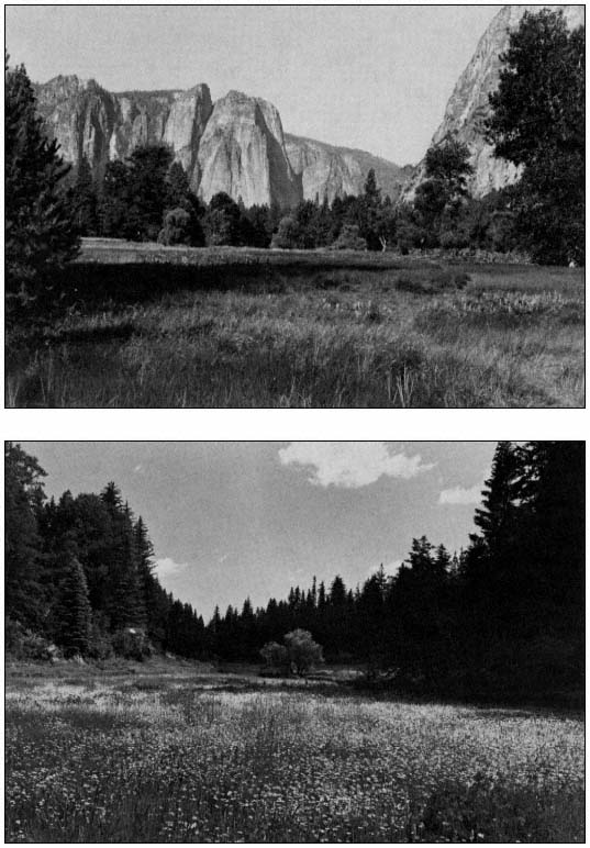
Natural areas are imperative to our wellbeing. By saving riparian systems, we will save values badly needed in our urban society. These areas provide the recreation, open space, and aesthetics that we need to maintain our physical and mental health. The only place I know where I can guarantee that I can take you in only a short drive from Sacramento where you can hear the wildness of a coyote howling, or see the splendor of a wild Sandhill Crane, is a riparian area on the Cosumnes River. This spot is a remnant of what California once was, and it is needed as an escape from the congestion of urban living. And, ironically, or maybe just as history tends to repeat itself, Man wants to conquer the Cosumnes River, and destroy the riparian vegetation along this, the last undammed river in the central Western Sierra Nevada. There is a proposal for up to 11 dams. What good are these dams, and the possible water and power they will provide, if we lose the aesthetics, the open space, and the ability to return to nature?
The concept of damming the Cosumnes is just a modern example of Man's greed and ignorance, destroying his environment as he has so often in the past. We can reflect on civilizations lost because of the overexploitation of resources: the Sumerians, Romans, Mayans, and Aztecs.
I also think of the Asazi Indians of New Mexico. A detailed account of their 12th century "conquest" of the Chaco Wash, a tributary of the Colorado River, can be found in "A River No More," by Phillip Fradkin (Knopf, 1981). This is a book I highly recommend. It gives a wonderful overview of the many problems faced by our river systems. The amenities of the location chosen by the Asazis included a meandering streambed which irrigated the canyon floor, and extensive pine forests. The native riparian vegetation was stripped for planting. Over 75,000 trees were felled to build structures. The massive disruption of vegetative cover and the denuding of the soil allowed Chaco Wash to become Chaco Canyon, a canyon 25 ft. deep and between 100 and 300 ft. wide. The riparian system, so complex and integrated, was destroyed. The Asazis moved on after destroying the amenities that attracted them to the spot in the first place. This is just one example of Man's tendency to ignore a system's carrying capacity and foul his nest. The Colorado River System alone gives numerous examples of poor resource management resulting from urbanization, water development, logging, grazing, agriculture, mining, and off-road vehicle use.
We now have an understanding of the problems we have created through poor resource management. The facts that over the last 150 years America has lost 70 to 90 percent of its indigenous riparian system—and over 90 percent in the Central Valley—and that salmon numbers, an indicator of the quality of our streams, have been declining steadily, until the point that we have now lost 65 percent, show us a trend of resource mismanagement. But we have really lost so much more than trees and salmon. There has also been a reduction in the quality of life and in the potential for recreational experiences. Many people use riparian and other forested areas as their way of returning to nature. John Muir's love for trees sent him around the world to write about them. In Muir's first book, "The Mountains of California," he describes the beauty of a
[1] Paper presented as a Keynote Speech at the California Riparian Systems Conference. [University of California, Davis, September 17–19, 1981].
[2] Huey D. Johnson is Secretary, The Resources Agency, State of California.
winter storm in the Sierra. He recounts the fragrance, the music, the colors, and the experience of climbing a 100-ft. Douglas fir to be a part of the tree traveling in the wind. We all need to be a part of nature, maybe not to this extent, but we all need that opportunity.
Laws and policies are helping us get a handle on some of these uses of riparian areas. In the North Coast, timber harvest regulations have tightened, and in the Central Valley we have learned about revegetation of levees. There is an increasing awareness of instream values, and we have been able to apply the Resources Agency wetlands policy to protect some riparian wetlands. But houses are still being built on the levees of the Sacramento River, and politicians are still serving special interests.
The Executive Orders which have protected our public lands from destruction by off-road vehicles have recently been attacked by James Watt. Wet meadows, and the highly fragile riparian systems which form the major basis for wildlife in California's arid and semi-arid areas, could have been open to an onslaught of off-road vehicles. But we fought, and we won the battle. However, the war goes on. And now there is a proposal to revise the grazing management regulations for Bureau of Land Management lands. The proposed change would undoubtedly accelerate desertification of our arid lands and destruction of sensitive riparian systems.
Just as we are getting somewhere, more problems arise. Just as we begin to understand an area, new mysteries unfold. We think we know the values of riparian systems, and are beginning to see the increased need for sustained yield use of all our renewable resources. Yes, riparian species can be beneficial for paper, fuel, and furniture, but what were we overlooking?
It brings to mind Azolla , a fresh-water fern, found here in Davis. When a rice farmer discovered it in his rice field, he called out crop dusters to apply aerial herbicides. Unbeknownst to him, this tiny fern is nitrogenfixing and has been used in Asia for centuries to nourish rice in lieu of chemical fertilizers. In a world faced with a steadily increasing population and soaring fertilizer shortages and costs, this "green manure" has increased the productivity of food crops and saved us energy. Just a few weeks ago, an article in the "San Francisco Chronicle" described the discovery of a tree in China that yields an oil similar to diesel oil. These trees are rapidly disappearing. Will this renewable resource be wisely used, possibly with energy farms, or overexploited? It is embarrassing to think that we could destroy something this valuable when we need it so badly—for every energy equivalent of a barrel of oil we get out of our crops we invest the equivalent of eight barrels in fuel, fertilizers, and pesticides.
What unknown discoveries lie in riparian systems? What part of our gene pool will we lose if we sit by and watch the other 10 to 30 percent be destroyed? The prime threat to species lies in loss of habitat. The economic exploitation of natural habitats must cease if we are to maintain the earth's stock of genetic material and preserve species diversity. Maybe some plant like Azolla , or a disease-curing insect, will be lost if we lose more of our riparian systems. Possibly the economic vitality of our nation depends upon riparian resources. It is up to the scientist to untangle the mysteries of riparian systems and to the managers and environmentalists to make sure that what we have left is preserved. And what can the politician and manager do to save these areas from destruction while the scientist ferrets out the secrets and develops methods for restoration and enhancement?
In response to problems such as those pointed out in the "Global 2000 Report," California has developed a program called "Investing for Prosperity." This 20-year plan states our resource management objectives. We can no longer sit back, watching the destruction of our natural systems. We need to restore our forests, renew our fisheries, reverse the loss of productivity of our farm and range soil, and make the wisest use of our energy resources. We have developed programs designed to achieve these goals. We have also included programs in urban areas to install awareness in the youth, the decisionmakers of tomorrow. What good is rehabilitation of salmon habitat today if tomorrow's leaders have no appreciation for its values and allow it to deteriorate once again? We must continue to expand upon our programs and involve enough people who will demand needed, enlightened, long-term management. One good example we could follow is a United Nations program being implemented in India. They call it "for-every-child-a-tree". The government will supply trees to be planted, nurtured, and appreciated by the children. In India they will be fruit trees; why not riparian species here? We need programs like this if an awareness is to be instilled in future generations while restoring areas.
"Investing for Prosperity" is only a step in the direction we need to take if we are going to manage our resources properly to insure the future for not just the next few generations, but for hundreds of generations to come. In what other way can we save the Cosumnes River, or the finest riparian forest we have left along the South Fork of the Kern? How can we get the public and private sectors to come together? These are some of the challenges that lie before us.
The pioneering work found in many of the papers presented at this conference, and the research which follows, will be instrumental in helping us to find a new path. But each individual can do only so much alone. We must unite and put our ideas together, form task forces to fight the forces that want to dam our rivers and destroy our remaining riparian systems. Our energies must be focused to provide a direct path away from the destructive tendencies of "progress" which we have been following and toward responsible, farsighted use of our resources.
Overview
National Trends in Floodplain Management[1]
Frank H. Thomas and Gerald D. Seinwill[2]
Abstract.—The federal role in floodplain management expanded greatly between 1960 and 1980 as flood-loss reduction, environmental-loss reduction, and disaster assistance programs were united in a national floodplain management concept. In the 1980s, reduced federal funding and regulation will force the leadership role in floodplain management upon each of the individual states.
Introduction
The organizers of this conference, and especially Rick Warner, are to be commended for providing a timely opportunity to assess the current and future status of riparian systems management. The management of riparian systems faces the challenge of adjusting to a redefined federal role, as expressed through reduced federal budgets and through a revised concept of federalism which vests leadership in the states, with the federal government playing a supporting role.
In this paper, we shall first assess the trends and current status of floodplain management from a national perspective, but with a focus on the federal role. We shall discuss the new concept of federalism and some of its implications for floodplain management. Throughout, we shall consider floodplain management as generally encompassing riparian systems.
National Water Policy 1960—1980
Context for Floodplain Management
The development of national water policy from 1960 to 1980 provides a context for understanding trends influencing floodplain management. This was a period in which the federal role expanded and specific federal programs were sorted out. There were repeated evaluations of water issues, first by the Senate Select Committee in 1961 and then by the National Water Commission, the National Commission on Water Quality, and more recently by the Carter administration. National goals were revised. Environmental quality became a national objective; water quality maintenance became a high-priority; and disaster assistance expanded greatly. The number of federal programs increased accordingly, first emphasizing planning and later regulations to solve water resource problems.
This was also a period of sorting out responsibilities within the federal government and among federal, state, and local governments. Informal and formal coordination mechanisms, including the US Water Resources Council, were established. Some states waited and followed the lead of the "Feds" while other states, like California, aggressively led the federal government. Except for communities located in the more aggressive states, local governments tended to wait for the federal lead and thus became increasingly dependent upon federal funds and projects.
In general, during this period the major water resource issues of the nation were defined, and in most cases the direction of resolution for these issues was set. It was a sometimes painful, incremental process of sorting out a federal role and programs. Today, the question associated with most water resource issues is "how to do it," rather than "whether to do it."
Development of National Floodplain Management
During the last two decades, the federal role in floodplain management also expanded, passing through the phases of reassessment, reconceptualization, and integration of related objectives. The reassessment was led by a 1966 task force on federal flood control policy, which concluded that more than 20 years of federal flood control had been inadequate to arrest rapidly rising flood losses (US 89th Congress 1966). The task force advocated greater reliance on nonstructural approaches to flood-loss reduction, including establishment of a National Flood Insurance Program. The task force recommended an executive
[1] Paper presented at the California Riparian Systems Conference. [University of California, Davis, September 17–19, 1981].
[2] Frank H. Thomas is Assistant Director for Policy and Gerald D. Seinwill is Acting Director; both are with the U.S. Water Resources Council, Washington, D.C.
order directing federal agencies to evaluate flood hazards before they located new federal installations. The Presidential executive order[3] issued immediately thereafter represented a first step for the coordination of federal flood-loss reduction activites.
In 1968, the Congress passed the National Flood Insurance Act,[4] which offered subsidized insurance in return for community regulation of future development in flood hazard areas. This quidproquo arrangement brought local communities into direct contact with federal floodloss reduction programs. This act also recognized the need for intergovernmental coordination and called for the President to prepare for the Congress "A Unified National Program for Floodplain Management," a task subsequently assigned to the US Water Resources Council.
In 1973 and 1974, Congress passed two acts strengthening federal flood-loss reduction efforts by linking flood insurance with federal disaster assistance.[5] Community participation in the flood insurance program was made a prerequisite for federal disaster assistance. State and local hazard mitigation and long-term disaster recovery were tied to the flood insurance program.
In 1977, Executive Order 11988—Floodplain Management, and its companion Executive Order 11990—Protection of Wetlands, directed federal agencies to avoid actions that would adversely affect floodplains and wetlands (US Water Resources Council 1978). The floodplain order states that if avoidance is not practical, agencies are to restore and preserve natural floodplain values as part of carrying out their action. It also cited the National Flood Insurance Act for its authority; from that act it established the insurance program's flood frequency standards as those to be used by all federal agencies. Thus, the floodplain management executive order became a significant mechanism for coordinating federal policies and programs. Since 1977, more than 50 federal agencies have issued procedures for implementing Executive Order 11988 at the field level.
In 1979, the Water Resources Council's "A Unified National Program for Floodplain Management" (US Water Resources Council 1979) was transmitted by the President to the Congress. Central to the unified program is a holistic conceptual statement articulating the policy linkages that had evolved between 1960 and 1980. Floodplain management is a decision-making process. The management goal is the wise use of the nation's floodplains, subject to two constraints: satisfactory accommodation of flood-loss reduction and environmental-loss reduction. Loss reduction constraints include equal consideration of: 1) all structural and nonstructural approaches; 2) all upstream and downstream impacts; and 3) all preflood, during flood, and postflood disaster assistance actions. This concept also recognizes that authority for floodplain decisions is partitioned by law among federal, state, local, and nongovernmental entities, and that at each level of government authority is further fragmented. For example, 28 federal agencies have major floodplain management program authority. The unified program provides a framework for articulating policy relationships and coordinating floodplain decision-making authorities.
In 1980, the Office of Management and Budget issued a directive to 12 federal agencies to coordinate postflood disaster recovery programs with long-term basin planning programs (US Office of Management and Budget 1980). Subsequently, interagency hazard mitigation teams have been sent to flood disaster sites to work with state and local government officials to ensure that federal disaster recovery assistance does not result in reconstruction or new development in high-hazard areas. This coordination effort has produced promising results thus far.
Current Status of National Floodplain Management
As we survey the scene in 1981, we find that progress has been made. First, we do have an adequate conceptual statement of national floodplain management in the US Water Resources Council's (1979) "Unified Program."
At the federal level, there are a number of useful coordinating mechanisms—the Office of Management and Budget directive, the executive orders, and the Floodplain Management Task Force of the Water Resources Council.
In the National Flood Insurance Program, a single program provides common floodplain delineation and risk standards used by all federal agencies, each of the 50 states, more than 17,000 communities, and over 2 million insurance policyholders. Indeed, the flood insurance program has become the backbone of national floodplain management.
We now face a major task in improving the effectiveness and coordination of existing programs. Few, if any, new programs are needed.
[3] President of the United States. 1966. Executive Order 11296. Evaluation of flood hazards in locating federally owned or financed buildings, roads, and other facilities, and in disposing of federal lands and properties. Federal Register 31(155). August 11, 1966.
[4] PL 90-448, 82 Stat. 572, 42 USCA 4001 etseq .
[5] Flood Disaster Protection Act (PL 93-234, 87 Stat. 980, 42 USC 4001 etseq .). Comprehensive Disaster Assistance Act (PL 93-288, 88 Stat. 163, 42 USC 5201).
New Federalism in the 1980s
With the advent of the Reagan administration, the concept of federalism is again evolving. The new federalism is based upon three premises: 1) problems should be solved at the level of government closest to the problem; 2) the federal budget is bloated; and 3) federal programs are overexpanded and unduly burdensome.[6] Accordingly, the administration has three action strategies to change the federal role.
The first strategy is devolution or shifting of federal responsibility to the state and local levels. Federal agencies will bear the burden of proof to justify their programs by answering the questions: 1) Why isn't this function at the state level? and 2) Why isn't this function at the local level?
The objective of this evaluation of federal programs is to strengthen state government at the expense of federal government and to keep a statusquo relation between state and local government. In order to insulate local government from the federal government, funds are to be channeled through states to local governments. The expected net result is a shift from federal leadership to that of federal assistance to support state and local initiatives.
The second strategy is to reduce the federal budget. The 1982 Budget Reconciliation Act[7] represents action by the Congress, with the support of the administration, to place a ceiling on federal budget expenditures. One major element of the act is an approximately $35 billion overall reduction in expenditures, primarily in program areas other than defense, the Social Security "net," and federal debt servicing. This translates into an estimated 20% reduction in the natural resource program category. Another major element in the act is the consolidation of individual grant programs into block grants in order to reduce administrative costs. Although no block grants were instituted in the natural resource program area in 1981–82, it is likely that some form of natural resource block grants to the states will be introduced in fiscal year 1983.
Apart from the Reconciliation Act, there is a clear trend toward full cost recovery in proposed legislation and in the federal role, as indicated by the Cabinet Council on Natural Resources and Environment. The federal role would be reflected in the principle that the cost of all services produced by water projects should be paid for by direct beneficiaries of the services. The implication is that we can expect new policies on discount rate financing and cost sharing for new water projects.
The third strategy, deregulation, is aimed at reducing the federal regulatory burden placed on local governments and private parties by simplifying regulations, terminating all regulations not explicitly required by legislation, and shifting responsibility for regulatory programs to state government. A Vice-Presidential task force has identified over 100 burdensome regulations, especially those affecting block grants. Three of these regulations directly affect riparian locations: Executive Order 11988—Floodplain Management; Executive Order 11990—Protection of Wetlands; and the regulations of the National Flood Insurance Program. A final decision on whether block grants will be exempt from the requirements of these regulations is expected soon. To this point, congressional initiatives aimed at reducing the regulatory burden have been very limited. In the near future, it seems certain that the Congress will take up the Clean Water Act Section 404 permit program, and may redefine the relationship of the Environmental Protection Agency and the US Army Corps of Engineers (CE) and transfer program implementation to the states.
Conclusion
Based on our assessment of the current floodplain management status and the new federalism, significant adjustments will need to be factored into the state strategy for riparian system management in California. The following observations are offered for consideration in the development of the state strategy.
(1) Expanded state leadership and responsibility for grants and regulations will cause intensified lobbying at the state level and will decrease the relative importance of federal decisions made in Washington.
(2) States will be less able to avoid issues by saying "the Feds made me do it," especially when federal regulations are relaxed, as is expected in the case of Section 404 permits.
(3) Because of a reduced federal role, adjacent states may have more frequent conflicts over management priorities for interstate floodplains.
(4) Reduced federal budget and full repayment policies could mean few if any new water project starts and more emphasis on nonstructural solutions to flood problems. States and communities now waiting for federal flood control project funds will have to fund or forget their projects.
(5) More emphasis on economic evaluation will increase the importance of flood-loss reduction costs as a negative factor for floodplain development. Environmental-loss reduction may
[6] Carlson, Robert, and James Kelly. 1981. Comments presented at the Federal Executive Institute's seminar "Reagan Federalism." [Washington, D.C., August 12, 1981.]
[7] Omnibus Budget Reconciliation Act of 1981. PL 97-35, August 13, 1981.
have to be carried more frequently under the standards of the flood insurance program.
(6) More emphasis on economic evaluation and benefit:cost analysis will increase the pressure for dollar evaluation of floodplain and other riparian values such as wildlife habitat, biomass production, etc.
(7) Floodplain and other riparian system managers will have to obtain more of their funds from nongovernmental sources. They will also have to find inexpensive tools for accomplishing preservation.
Finally, there is a lack of explicit performance goals with completion deadlines. Targets are needed so that progress can be measured. In California:
(a) Can the losses of floodplain and other riparian natural resources be reduced by a fixed number of acres or units by the year 1990?
(b) Can a certain number of acres or units of riparian system be restored by 1990?
(c) Can the federal agencies with large land holdings in the state be formally brought into a state restoration and preservation program?
(d) Can the state establish and pursue finite performance goals for riparian systems management?
Literature Cited
US 89th Congress, 2nd Session. 1966. A unified national program for managing flood losses. House Document 465. Government Printing Office, Washington, D.C.
US Office of Management and Budget. 1980. Nonstructural flood protection measures and flood disaster recovery. Executive Office of the President, Washington, D.C. July 10, 1980.
US Water Resources Council. 1978. Floodplain management guidelines (includes Executive Order 11988 and Executive Order 11990). Federal Register 43(29) February 10, 1978.
US Water Resources Council. 1979. A unified national program for floodplain management (revised 1976). Government Printing Office, Washington, D.C.
Important Riparian/Wetland Systems of Peninsular Baja California
An Overview[1]
Norman C. Roberts[2]
Abstract.—The peninsula of Baja California, Mexico, and its phytogeography are described. Climatological factors and their historical and present impact on the land and its inhabitants are noted. An inventory of peninsular wetlands and some of the dominant plants are provided. Some conclusions concerning the future of the peninsula are presented.
Introduction
Riparian/wetland systems, for the purposes of this paper, are defined as being periodically, seasonally, or continually submerged lands populated by species and/or life forms different from those of the immediately adjacent vegetation, maintained and dependent upon conditions more mesic than those provided by the immediate precipitation (Brown 1978).
While the original Latin usage of the term "riparian" apparently related to freshwater, the term has occasionally been applied to tidewaterand estuarine-adjusted zones (Warner 1979). Tidelands have been included in this study because of their critical importance to the future of both the peninsula and the adjacent seas of Baja California, Mexico.
Geography
Baja California is a jagged finger of land extending from the southern border of California to south of the Tropic of Cancer. It wanders irregularly south and east from latitude 32°30'N and longitude 117°W at the northern International Boundary and Tijuana, to terminate in the Pacific Ocean 1,300 km. further south at Cabo San Lucas (22°50'N, 110°W) after penetrating well past the Tropic of Cancer.
The peninsula is separated from mainland Mexico by a 160-km. wide body of water usually known as the Gulf of California or the Sea of Cortez. To the west and south lies the Pacific Ocean. Baja California varies in width from 250 km. at the International Border in the north to 135 km. at the Bahía de La Paz, 155 km. above its southernmost tip. Baja California comprises an area of 143,790 km2 , and has 3,240 km. of shoreline. Figure 1 illustrates the geography of the region and indicates locations of sites referred to in the following discussions.
Geology
The peninsula split off the mainland 25 million years ago and began moving northwest. It has continued to do so at the rate of 1.5–3 cm. per year ever since, widening the Gulf as it moves (Anderson 1971). In addition, most of the peninsula, with the exception of the northern mountains, those at the Cape, and a few peaks in between, underwent submergence during the Miocene period (ibid .; Murphy 1975).
The relatively recent geologic separation of the peninsula from the mainland has been a somewhat limiting factor in the development of endemic species of plants (Wiggins 1980). There is, however, a high degree of endemism, or nearendemism, of both floral and faunal elements on the peninsula (ibid .; Savage 1959).
Climate
The climate is generally hot and dry over most of the peninsula. Average annual rainfall ranges from 250 mm. at Tijuana, 200 mm. at Ensenada, 125 mm. at San Quintín, 100 mm. at El Rosario, to 50 mm. mid-peninsula. The highest mountain ranges of both the north and south, however, each receive approximately 750 mm. of annual precipitation.
Most of the peninsula has a two-season rainfall pattern. In the northern mountains, 70% of the precipitation occurs in winter—some in the form of snow (particularly in the Sierra de San Pedro Mártir)—and 30% occurs in the summer. The Sierras de la Giganta and de la Laguna in the
[1] Paper presented at the California Riparian Systems Conference. [University of California, Davis, September 17–19, 1981].
[2] Norman C. Roberts is Staff Assistant, U.S. Department of Interior, Washington, D.C.
[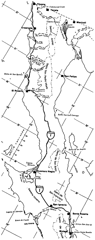
Figure l.
Map of Baja California (northern portion).
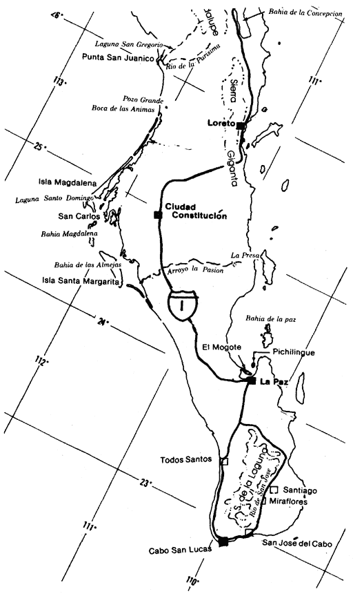
Figure 1 (cont.)
Map of Bajaj California (southern portion).
Cape Region receive 70% of their rainfall during the summer months (Hastings and Humphrey 1969). Both the Desert Region and the lower elevations of the Cape Region receive 50% or more of their precipitation in the summer.
Three general types of storms occur on the peninsula. Winter cyclonic storms moving south from the Gulf of Alaska bring rain to the north. These weaken as they move south, seldom reaching beyond the northern mountains. During the summer and fall, monsoon storms, also known as "Sonora storms", come across the Gulf of Baja California from the Mexican mainland. These are sometimes called "aquaceras" or "equipatas;" the former bring more rain to larger areas than the latter.
Tropical cyclonic storms that originate off Acapulco in the southeastern Pacific are known as "chubascos" by the natives of Baja California. Due to the violent nature of these storms and the winds accompanying them, the potential benefit of
the rainfall is more than offset by the damage done as water rushes down the arroyos to the sea.
Normally chubascos do not make it as far north as California. However, on 10 September 1976, "Kathleen" reached the head of the Gulf and slammed into Southern California with winds of up to 160 km. per hr.[3] The storm caused at least 10 deaths and damage in excess of $10 million in San Diego and Imperial Counties. The northern peninsula was unaffected by "Liza" which followed "Kathleen" on 28 September 1976. The same cannot be said for La Paz; winds of up to 208 km. per hour and torrential rains burst a dam near the town and buried between 2,000 and 3,000 inhabitants.[4]
The San Diego Union reported the final chubasco of the season on 12 October 1972, "El Cardonoza de San Francisco", the shiplash of St. Francis. It dumped 250 mm. of rain on San Felipe in two days.[5] The average annual rainfall in San Felipe is only 55 mm. (Humphrey 1974).
In September, 1939, four chubascos struck Bahía de Magdalena, dumping a total of 570 mm. of rain. Between 1939 and 1962, the same area received an additional 750 mm., equal to 57 mm. annually.[6]
During the fall of 1978, in Arroyo de la Pasión, north of La Paz, one goat rancher measured 6 m. of water rushing past his house in what had been a dry stream bed the previous week.[7]
But there have been times when peninsula natives prayed for a chubasco. There have been periods of up to four years when not one drop of rain fell in some areas. During one dry period, or "seca," Antero Dias of Bahía de Los Angeles fed viznaga (barrel cactus) (Ferocactus spp.) and cardóns (Pachycereuspringlei ) to his livestock. The cacti were made more palatable by dousing them with kerosene and then lighting them to burn the spines.[8] During these dry years untold damage is done to the vegetation by overgrazing.
Phytogeographic Regions
There is considerable variation in the vegetative elements within the 1,300-km. peninsula. Additionally, the altitude goes from sea level to 3,096 m., and annual precipitation varies between 50 and 750 mm. The phytogeography of the peninsula is best characterized as three more or less distinct vegetative zones: the California Region, the Desert Region, and the Cape Region (Wiggins 1959).
The California Region can be considered an extension of the southwestern California mountain ranges and their Pacific slopes. The Desert Region includes the eastern scarps of the northern mountain ranges, the central one-third of the peninsula, with the exception of the Sierra de la Giganta and the Cape Region. The Desert Region is generally divided into four subregions. The Cape Region includes the Sierras de la Laguna and de la Giganta ranges in addition to their drainages, and the southern mangrove forests on the seacoasts.
The California Region
The California Region includes the mountains and their western drainages to the Pacific Ocean from the International Border to the southern terminus of the Sierra de San Pedro Mártir. The transition to desert vegetative elements is gradual, becoming increasingly xeric from north to south coinciding with decreasing rainfall. On the Pacific slopes, this transition is well advanced at El Socorro (30°17'N), a few kilometers below Bahía San Quintín.[9]
There are two principal mountain ranges in the California Region. They are considered extensions of the peninsular ranges of Southern California and San Diego County. The northern-most, the Sierra Juárez, extends from the International Border south to Valle Trinidad, and has the highest representation of Southern California flora. Vegetation at the higher elevations consists of yellow pine forest and Jeffrey pine (Pinusjeffreyi ), with a more or less typical chaparral group below, replaced by coastal sage scrub to the west as the elevation declines. The Sierra Juárez range average elevation is 1,400 m.
The Sierra San Pedro Mártir is the highest range in Baja California with an average elevation of 2,700 m. The forests are generally more open than those of the Sierra Juárez. Jeffrey pine is dominant, with sugar pine (P . lambertiana ) occurring on the ridges. Lodgepole pine (P . murrayana ) and quaking aspen (Populus tremuloides ) are also found there, but not in the Sierra Juárez or in San Diego County. This range is a climatic island with the closest comparable plant community being the Santa Rosa Mountains 250 km. to the north.[10] The Sierra San Pedro Mártir lies at the southern
[3] San Diego Union, September 12, 1976.
[4] San Diego Union, October 3 and 4, 1976.
[5] San Diego Union, October 12, 1972.
[6] Schwenkmeyer, Richard. 1977. Baja California seminar, San Diego Natural History Museum, San Diego, California.
[7] Rancher at El Paso, in Arroyo de la Pasion, Baja California Sur. 1978. Personal communication.
[8] Dias, Antero. 1973. Personal communication, Bahía de Los Angeles.
[9] Moran, Reid. 1975. Plant life of Baja California, Baja California Seminar, San Diego Natural History Museum, San Diego, California.
[10] Moran, Reid. 1977. Plant geography of Baja California. Presented at Biogeography of Baja California Symposium, California State University, Fullerton.
extreme of the north temperate zone, influenced by both the Pacific and Gulf climates (Hastings and Turner 1965). This climatic interaction with the regional topography creates the greatest diversity of speciation and habitat to be found on the peninsula (Wiggins 1980).
The vegetation of the riverine corridors in the California Region is generally characteristic of comparable undisturbed riparian systems in Southern California. Riparian systems on the Pacific slopes of the peninsula all share many characteristics. At higher elevations and in the numerous deeper canyons, characteristic willow (Salix spp.), cottonwood (Populusfremontii ), oak (Quercus spp.), and sycamore (Platanusracemosa ) bosques remain with minimal disturbance. The streams are semi-perennial at lower elevations because of agriculture in the lower valleys and floodplains. None reach the sea except during heavy rains and flooding. With the exception of Río de Tia Juana, no major dams or water projects obstruct the arroyos of the peninsula.
Flooding during cyclonic storms from the north or south continues to discourage extensive human invasion in the canyons. In the valleys and on the coast, however, bridges, dikes, and flood channels are now being built to protect agricultural projects. When first constructed in 1973, trans-peninsular Highway 1 had few bridges along the 1,600+ km. stretch from the northern border to the tip of the peninsula. Truck and passenger traffic is increasing, and bridges are reconstructed after the roads are washed out during storms.
Although each riparian system exhibits individual characteristics, certain species are common in systems that have remained relatively pristine. The overstory may be open or closed, with willow the dominant tree comprising most of the overstory, along with sycamore, cottonwood, and oak. The understory is composed of Ceanothus spp., coffeeberry (Rhamnus californica ), scrub oak (Quercusdumosa ), chamise (Adenostomafasciculatum ), rose (Rosa minutifolia ), arrowweed (Pluchea spp.) and Baccharis spp., as well as willow.
The Río de Tia Juana is the northernmost, and one of the more extensive riparian systems in the California Region. It is formed by the confluence of two major drainage systems, one on either side of the International Boundary. The mouth of the river is 135 km. from the most distant source. One of the two tributaries joining to form the Río de Tia Juana is the Río de las Palmas. A Baja California semi-perennial stream, during periods of drought it is dry over much of its course. Along the river where agriculture is not extensive, there are numerous stands of willow and sycamore. Farther east, cottonwoods and oaks join the riparian corridor. At lower elevations or in disturbed areas, Baccharis and arrowweed are found.
The second tributary of Río de Tia Juana is Cottonwood Creek. It drains a considerable area in southern San Diego County, becoming Arroyo del Alamar as it crosses into Baja California 9 km. east of the Pacific Ocean. It joins Río de las Palmas, then becomes Río de Tia Juana just east of the town of Tijuana. The river is being channelized through the city of Tijuana.
The sole major dam on the peninsula is Presa Rodriquez located 11 km. east of Tijuana. Constructed in 1937, it impounds water from Río de las Palmas. There are seven major dams in San Diego County alone draining a much smaller area of comparable mountain ranges. The lake impounded by the dam is now 7 km. long. The spillway was in use all during the spring of 1981. Five years ago however, the lake bed in its entirety was farmed. It was also a dry lake bed in the early 1960's.
Valle de las Palmas, 30 km. above the dam, has extensive olive and other fruit orchards in addition to variegated crops. The valley is so named because of a generous stand of California fan palms (Washingtoniafilifera ) that existed in previous years. Although common in the peninsular deserts, this was the only grove on the Pacific slopes of northern Baja Califorfornia. Most of the trees fell to the machete long ago.
The Tia Juana River estuary is located on the American side of the International Border, its southern bank adjacent to the International Boundary marker at the Pacific Ocean.
"The Tia Juana Estuary of San Diego is recognized by ecologists as a model ecosystem, to be used in determining how to restore many modified coastal wetlands in the San Diego region. Its structure and function have been examined in detail and compared with other local wetlands, as well as more disturbed parts of Tia Juana Estuary itself, in order to establish how activities such as reduced tidal exchange, altered elevation, reduced species diversity, and altered channel morphology have changed southern California coastal wetlands."[11]
Río Guadalupe is the next important stream to the south. It flows west from its origin in the Sierra Juárez (32°5'N). Río Guadalupe is fed by springs and contains the only lake in the Sierra Juárez range, Laguna Hansen. Both the Río Guadalupe and Laguna Hansen sometimes go dry during long secas. The estuary at the mouth of the river is located at La Misión. This formerly rather extensive estuarine system has been drastically changed by the presence of several wells pumping water north 55 km. to the city of Tijuana. The estuary is now a salt water lagoon.
[11] Zedler, Joy. 1981. Personal communication.
Throughout most of its 100-km. course the river has been altered by heavy demands on the water table in the valleys through which it flows. Only at the higher elevations in the coniferous and chaparral zones of the mountains and in few steep canyons has the ecosystem remained relatively pristine.
Río San Carlos (31°45'N), another semi-perennial stream similar to Río Guadalupe, originates 30 km. to the south of Río Guadalupe. Its arroyo reaches the ocean at Estero Beach below Ensenada. There are at least three geothermal seeps along the river. The Río San Carlos corridor runs through chaparral for much of its course. Extensive dryland farming is practiced in the Ojos Negros Valley through which the river flows. For several kilometers at lower elevations, the river passes through an oak woodland with only subsistence farming to disturb the riparian system. The riparian corridors of this drainage include Tecate cypress (Cupressus forbesii ) in some arroyos at lower elevations. A small population of western pond turtles (Clemmysmarmorata ), and introduced bullfrogs (Ranacatesbeiana ) occur above the resort of San Carlos, inland from Ensenada.
Río Santo Tomás (31°35'N), the next semi-perennial stream to the south, crosses Highway 1 approximately 40 km. south of Ensenada. Originating from a seep in the chaparral zone below the almost abandoned mining town of El Álamo, the riparian vegetation has remained relatively undisturbed for the first half of the corridor to the sea. For 25 km. the stream courses through one of the most beautiful arroyos in the northern peninsula.
Evidence of increasing xerification becomes apparent in this arroyo as northern riparian elements are joined by stands of cholla (Opuntiacylindropuntia ), Our Lord's candle (Yuccawhipplei ), and "pitaya agria" (Machaerocereusgummosus ), which nears the northernmost extension of its range in this arroyo. Western pond turtles and red-legged frogs (Ranaaurora ) are found in the river east of Highway 1.
Río San Vicente (31°30'N) (fig. 2) is the southernmost of the western-flowing streams originating in the Sierra Juárez drainage system. Like the others in this northern mountain chain, it remains relatively unaltered by humans wherever it passes thorough steep canyons. At lower elevations, or where subsistence farming is practiced, the native vegetation is substantially altered. Río San Vicente disappears into the sand during secas, leaving a dry stream bed with a few pools remaining. From its origin to the sea, it has one of the longest courses of any stream in the Sierra Juárez, nearly 100 km. Populations of Tecate cypress occur in the foothills and arroyos of this area.
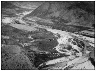
Figure 2.
Arroyo San Vicente above the town.
Río San Rafael (31°07'N) is the northernmost drainage system of the Pacific slopes of the Sierra de San Pedro Mártir. It has few entering tributaries, and until recent years was little disturbed over much of its course. Considerable water flows down this arroyo during storms (Welsh 1976). Arroyo San Rafael has a more direct corridor than other drainages to the north and is usually a permanent stream until it reaches the floodplain. Heavy willow bosques are dominant in the upper portion of Arroyo San Rafael. There is considerable agriculture for the final 20 km. of the river as the canyon opens into the floodplain and water sinks into the streambed.
The next large drainage system to the south is Arroyo San Telmo. It crosses Highway 1 in a broad valley at 30°55'N, 11 km. below Arroyo San Rafael. There is substantial agriculture along much of its course. The stream disappears in the upper San Telmo Valley 40 km. from the ocean. At higher elevations however, considerable undisturbed native woodland remains.
Continuing southward, Arroyo Santo Domingo (30°55'N) is located 15 to 25 km. south of Valle San Telmo. This stream has considerable pristine vegetation with few ranches because of the inaccessibility of the riparian corridor. At Mission Santo Domingo, the arroyo widens into a floodplain. For the remainder of its course to the sea, about 11 km., the arroyo intermittently carries water. Like most other streams of the California Region, it is characterized by heavy willow bosques along the streambed, joined by arrowweed and Baccharis at lower elevations and in agricultural areas.
In the arroyos of the California Region, the vegetation of the transition zones (upland to riparian) may include junco (Juncusacutus ), oak, mountain mahogany (Cercocarpusbetuloides ), toyon (Heteromelesarbutifolia ), Rhus spp., Ceanothus spp., and in some areas Tecate cypress.
Bahía de San Quintín (fig. 3) is the first salt water lagoon of major significance south of the International Boundary. The average annual
Figure 3.
Estero de San Quintín.
rainfall there is 120 mm. This relatively pristine salt marsh is located 275 km. south of Tijuana at 30°31'N. It is quite similar to the few remaining undisturbed Southern California salt marshes (Neuenschwander etal . 1979).
The bay itself is large, resembling an inverted J with the rounded base pointing towards the sea. From the entrance to the uppermost salt marsh is approximately 11 km. Much of the bay is shallow; the channel is tortuous and difficult to navigate even for small ocean-going fishing vessels.
The littoral marshes have dense stands of eelgrass (Zosteramarina ) in the channel bottoms. The channel banks are lined with cordgrass (Spartinafoliosa ), as well as glasswort (Salicorniabigelovii ) and saltwort (Batismaritima ) (ibid .). Three vegetationtypes dominate the upper, middle, and lower littoral; they are salt cedar (Monanthochloelittoralis ), pickleweed (S . virginica ), and cordgrass, respectively (MacDonald and Barbour 1974).
The Desert Region
The Desert Region includes the eastern escarpment of the northern mountain ranges. The mountains are precipitous, dropping sharply between 1,000 and 2,000 m. to the desert floor. The Sierra de San Pedro Mártir escarpments in particular are spectacular, with the highest peak, Picacho del Diablo, rising abruptly to over 3,096 m. from the San Felipe Desert to the east.
The eastern scarp of the Sierra Juárez has several deep canyons cutting into the mountains. These narrow streambeds have steep gradients and are often relatively straight in their course to the desert, where they fan out sharply into large fans known as "bajadas" by the natives. Several of these canyons have water year-round and some also have geothermal seeps. In the Sierra Juárez all the larger arroyos, except the northernmost, are palm-lined with California fan palm and the endemic blue palm (Braheaarmata ).
The largest and most beautiful of these canyons is called Tajo (Cantilles Canyon to early botanists). It usually carries water thoughout the year. Other picturesque palm canyons in the range are Carrizo, Guadalupe, and Palomar. During the summer and fall however, none have sufficient streamflow to reach their respective bajadas in the desert. These bajadas are littered with trunks of palms and large boulders washed down from higher elevations in the canyons during the often violent storms that occur in this region.
The eastern escarpment of the Sierra San Pedro Mártir also has several steep canyons cutting into its eastern face—Las Canada, del Diablo, Toledo, Oso, San Marcos, and San Luís. None have palms however, possibly because of their steep gradient (Rodriquez 1981). Like those of the Sierra Juárez, they have some water throughout the summer. In recent years, there has been considerable invasion of tamarisk (Tamarix spp.) in many of these arroyos.
The southwestern extension of the Colorado Desert, known as the San Filipe Desert, extends south along the eastern scarps of the northern mountains to join the Central Desert southwest of the town of San Felipe, above 30°N. The San Felipe Desert is considered the driest area on the peninsula—annual rainfall is 50 mm. One weather station in the northeast records 31 mm. of rainfall annually (Hastings and Humphrey 1969). In this region evaporation from a pan occurs at an estimated annual rate of 350 mm. per year during the summer.[12]
East of the Sierra Juárez, in an area formerly known as Laguna Salada, a new freshwater lake is now being formed. It is known as Laguna Maquata and extends from a few kilometers below the International Border south for 30 km. Laguna Maquata is being filled by a canal running north and west from the Río Hardy, a branch of the Río Colorado. It could become an important agricultural and vacation area for Mexicans in the future. The impact this lake will have on the surrounding desert is unknown.
Further east in the Colorado Desert lies the Mexicali Valley and the channelized Lower Colorado River. Both the Imperial and Mexicali Valleys are gradually being filled in by siltation from the Colorado River and peripheral canals. Because of irrigation and the canals involved, the Río Colorado no longer empties directly into the Gulf of California. However, the canals are dumping silt and salts into the upper Gulf, filling both it and the San Andreas
[12] Bloyd, Richard M. 1978. Water Resources talk presented at the California Desert Advisory Comm., USDI Bureau of Land Management public forum, Riverside, California.
Fault running down the middle of the Gulf. Ultimately this silt will raise the floor of the Gulf sufficiently to cause flooding of the entire adjacent low desert region.[13]
A detailed discussion of the Colorado River has been omitted. Originating far to the north, less than 200 km. of its long course to the Gulf of California winds through Mexico; it is not a Baja California river. Previous riparian symposia have adequately discussed the lower Colorado River (Ohmart etal . 1977; Johnson 1978).
Río El Rosario (30°5'N) is the last of the perennial streams with drainage from northern mountain ranges. It is formed by the confluence of two large arroyos, Rosario and Cardonal. The tributaries originate on either side of Cerro El Matomí (30°40'), a 1,500 m. desert peak 30 km. below the southern slope of the Sierra de San Pedro Mártir range, only 30 km. from the Gulf. In this area, the transition to Desert Region vegetation is nearly complete. Chaparral and coastal sage scrub have disappeared.
Both Arroyo El Rosario and Arroyo El Cardonal are pristine over much of their drainages and represent the first streams to be found in a "cardonal", a cardón (Pachycereus pringlei ) forest. Arroyo El Rosario has been particularly subject to flooding during chubascos, and occasionally from northern storms in winter. In recent years, numerous wells have been drilled and crops are being raised where the arroyo widens 30 km. east of the ocean. In times of drought, both Río El Rosario and Río El Cardonal dry up, leaving only a few pools in protected areas. The average annual rainfall at El Rosario is 100 mm.
Laguna Manuela (28°10'N) is a substantial estuarine system. This narrow, shallow lagoon and the much larger adjacent Estero de San José (Guerrero Negro) are extensive and relatively untouched salt water estuarine marshes. They form part of the huge Ojo de Liebre (Scammons Lagoon) complex located in the region of 28°N, the state boundary between Baja California Norte and Baja California Sur. Laguna Ojo de Liebre extends nearly 60 km. into the Vizcaíno desert.
Much of the inland, or eastern, area of Scammons Lagoon is botanically rather sterile and is diked for salt production. These huge salt beds are known as Salina Vizcaíno. It is the largest seawater salt-producing facility in the world. Both Estero de San José and Laguna Manuela have rich biotas, however. Like many of the Pacific saltwater marshes they have beach barrier formations in which fine sandy sediments dominate (MacDonald and Barbour 1974). The species composition and zonal distribution in Estero de San José are apparently quite similar to that of San Quintín with cordgrass, salt wort, glasswort, and salt cedar again succeeding one another as the elevation increases (ibid .).
No gray whales (Eschrichtiusgibbosus ) enter Laguna Manuela, but they winter and calve in adjacent Laguna Ojo de Liebre. Formerly a favorite visiting site for whale watching by boat, Scammons Lagoon has been closed by the Mexican Government to protect the whales. There is, however, a road off Highway 1 where visitors can watch whales from shore.
To the immediate south is the Laguna Abreojos/Estero del Coyote/San Ignacio group of marshes. San Ignacio (27°N) (fig. 4) is the largest of the three lagoons and extends into the Vizcaíno Desert 30 km. It is deep enough for large vessels. The Abreojos and Estero de Coyote lagoons are too shallow and narrow for ships. All three lagoons have extensive salt marshes with scattered mangrove shrubs and estuarine systems.
Figure 4.
Laguna San Ignacio, south side.
There are four species of mangrove-like plants occurring in Baja California: black mangrove or "mangle negro" (Avecennia germinans ), white mangrove or "mangle blanco" (Lagunculariaracemosa ), "mangle dulce" (Tricermaphyllanthoides ), and red mangrove or "mangle rojo" (Rhizophoramangle ). Another bush tree in the family Combretaceae that occurs in this region is the button mangrove (Conocarpuserecta ). It is sometimes called "mangle" by the natives.
Laguna Abreojos, also called Pond Lagoon, is the northernmost Pacific extension for white and red mangrove in the low marsh, with saltwort and glasswort dominating the littoral marshes at higher elevations.
[13] Jahns, Richard. 1978. Geological History talk presented at the California Desert Advisory Comm., USDI Bureau of Land Management public forum, Riverside, California.
Laguna San Ignacio has a 25-km. wide opening interrupted by a large, mostly sand barrier island known as Isla Arena, 15 km. long. South of the lagoon and island, shallow tidal lagoons extend for another 35 km., to 26°38'N. Gray whales winter in this lagoon and whale watching trips are popular. Vegetative elements in Laguna San Ignacio include white mangrove, red mangrove, and cordgrass in the low marsh; with glasswort, saltwort and salt cedar occurring in the high marsh.[14] The eastern and southeastern shore of the lagoon is called "La Laguna" locally. It is the largest marsh area of the complex. In the low marsh dominant vegetative elements are red mangrove followed by white mangrove with some cordgrass. The high marsh is dominated by saltwort mixed with glasswort.[15]
Río San Ignacio (fig. 5), located midpeninsula between 27°N and 28°N at 113°W, is the first true river south of the northern mountains. It flows west from a long, narrow, springfed lake at the town of San Ignacio. The elevation is 165 m. at the lake and town. Annual rainfall of the area is slightly under 130 mm. At the river's origin and around the town, native vegetation has been replaced largely by date palms (Phoenixdactylifera ), introduced by the missionaries. Dates are the only important industry of San Ignacio, there being no other agriculture with the exception of family gardens and a few cattle.
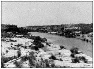
Figure 5.
Arroyo and Río San Ignacio.
The geology of the San Ignacio region is similar to much of the Vizcaíno Desert: an ancient sea bed overlain with volcanic rocks, some of which are of recent geologic origin. Río San Ignacio winds its course west towards Laguna San Ignacio and the Pacific Ocean for approximately 30 km., disappearing into the sand as the shallow arroyo widens into the open Vizcaíno Desert. The river fails to reach Laguna San Ignacio by 20 km.
Río San Ignacio has been little disturbed by man; there are only two ranches located along the riparian corridor. These are both subsistence operations—one raising a few cattle and the other, goats. The riverbed itself is either lava rock, "caliche", or sandstone, affording little nourishment for plants. Below the palm grove and town of San Ignacio, a mesquite (Prosopis spp.) bosque follows the course of the river. There has been a considerable invasion of introduced tamarisk in some areas.
Bullfrogs have been introduced into the lake at the town of San Ignacio but they have not extended their range to the river below the date palm grove. Río San Ignacio is the northernmost extension of the range of pond slider (Chrysemys scripta on the peninsula (Van Denburgh 1922; Roberts[16] ).
Laguna San Gregorio (26°7'N) is a 10-km. long, narrow estuary just east of Punta San Juanico. Prior to 1958, the mouth of the lagoon was open and ships had navigated it for decades. A chubasco in 1958, followed by another in 1959 (a rare occurrence) caused extensive damage and several deaths in the area. The storm also closed the mouth of the laguna with a sand barrier.[16] It has remained shut to seagoing ships since then. The estuary is below the confluence of two of the larger Pacific drainage systems of the Sierra de la Giganta. The northernmost of these, Arroyo San Gregorio, has water over some of its riparian corridor only during wet periods.
Intertidal vegetation of Laguna San Gregorio includes some new elements in addition to the common high marsh species found at Laguna San Ignacio. Sea purslane (Sesuvium portulacastrum ) and iodine bush (Allenrolfea occidentalis ) are both found in the estuary. Other than red mangrove seedlings, there are no mangroves in this marsh. Dominant vegetative elements are saltwort and glasswort.[17]
The Río de la Purísima (fig. 6) is the next drainage system to the south of Río de San Gregorio; it empties into Laguna San Gregorio, flowing from the heart of the Sierra de la Giganta range from the region of 26°20' southwest to the lagoon. This is the largest perennial stream of the southern peninsula. It flows above ground for approximately 32 km. Midway a low dam, El Zacatón, about 300 m. long, blocks the arroyo, creating a shallow lake. There are numerous larger pools along the course of the
[14] Mudie, P.J., A. Johnson, J. Rutherford, and F.H. Wolfson. 1975. Shoreline vegetation of Baja California. Unpublished report prepared for Foundation of Ocean Research, San Diego, Calif.
[15] Mudie, Peta J. 1981. Personal communication.
[16] Roberts, Norman C. 1981. Unpublished manuscript.
[17] Mudie, Peta J. Diversity in the salt marsh floras of Southern California and western Baja California. Unpublished manuscript.
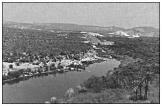
Figure 6.
Río de la Purísima.
river; many have apparently stable populations of pond sliders. Downstream from the dam two small towns, San Isidro and La Purísma, have subsistence agriculture using water from a dam flume. Several kilometers below the towns, the stream flows through limestone caliche and the water sinks into the stream bed.
Willow, "torote" (Bursera spp.), "palo verde" (Cercidium spp.), "palo colorado" (Colubrina viridis ), "palo adan" (Fouquieriadiguete ), "lomboy" (Jatropha spp.), "garambullo" (Lophocereusschottii ), mesquite, and cholla are all found in the riverine corridor.
The Cape Region
The southernmost phytogeographic region of the peninsula includes the Sierra de la Laguna (Cape Mountain Range) and the Sierra de la Giganta, a lesser range that extends northwest along the Gulf of California towards Bahía Concepcion. The Sierra de la Laguna extends nearly due north from 23°N to 24°10'N. This range consists primarily of granitic blocks, while the Sierra de la Giganta is volcanic in origin. Floristic elements of the two ranges are similar; both have semi-deciduous forests that share many species of plants not found in other regions of the peninsula (Carter 1980).
The vegetative elements of the region are widely diversified, generally dry and tropical, but with pine/oak woodland only at the higher elevations of the Sierra de la Laguna. At lower elevations is semi-deciduous forest prominent in leguminous trees and shrubs.
Southern peninsular coastal salt marshes and mangrove swamp forests have been included in the Cape Region flora (Wiggins 1980). These forests are extensive in the larger saltwater lagoons and estuaries. They are found from Laguna Abreojos (26°50') south around the Cape and north in the Gulf to Bahía de Los Angeles (29°N).
Bahía Magdalena (fig. 7, 8) is 960 km. south of San Diego. It is the third and southernmost of the gray whale mating grounds on the peninsula. The bay area covers approximately 260 km2 composed of quiet deep water with a network of uncharted small canals, islets and islands of estuarine character.
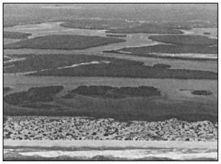
Figure 7.
Boca de las Animas, upper end of Magdalena Bay.
Bahía Magdalena (fig. 8) is the largest and most extensive saltwater lagoon on the peninsula, and contains a most impressive deep water harbor. The bay extends from the town of La Poza Grande (25°45'N) over 200 km. south in a dog-leg that terminates in a narrow shallow lagoon. Much of Bahía Magdalena is separated from the Pacific Ocean by narrow sand barriers that are often submerged during major storms.

Figure 8.
Magdalena Bay, south end.
The sea entrance to Magdalena Bay is protected by two large islands, Isla Magdalena and Isla Santa Margarita. Isla Magdalena, the northern island, is 100 km. long, low, narrow, and mostly sand. It protects the section of Magdalena Bay known as Laguna Santo Domingo and the port of San Carlos, used by ocean-going vessels for commerce. Isla Santa Margarita, to the immediate south, is mountainous and 40 km. long. The principal bay is 40 km. long and 25 km. wide.
The channel running between Puerto San Carlos and Puerto Lopez Mateos 45 km. to the north is known as the Hull Canal. This is a favorite playground for the gray whale. When the tides are favorable, smaller ocean vessels can navigate this canal north to the town of La Poza Grande from Puerto San Carlos.
Ciudad Constitución, located on Highway 1 in Valle Santo Domingo, is 58 km. inland from Puerto San Carlos. The valley, formerly a broad cardonal, has for the past decade been under intensive agricultural development. Hundreds of irrigation wells perforate an underlying fossil aquifer. Within a few years this irreplacable water supply will be depleted and saline. Rainfall in the area is replacing less than 10% of the groundwater being removed at present rates (Palacios 1978).
The wetland vegetative elements of Magdalena Bay include: red mangrove, cordgrass, and white mangrove in the low marshes; saltwort, salt cedar, and black mangrove in the high marshes. In the estuaries are iodine bush, a glasswort (Salicornia subterminalis ) and mangle dulce.[15]
Dense beds of eelgrass occur in most of the lagoons but are absent from the estuaries. Ditchgrass (Ruppia maritima ) is found in shallow open ponds in the salt marshes and mangroves. Red mangrove is the dominant mangrove species from Laguna Santo Domingo south. Black mangrove joins the other mangroves at Laguna Santo Domingo. It is much more common in the Gulf because of the warmer waters (MacDonald and Barbour 1974). Red mangrove increases in height southward from Laguna Abreojos and becomes the dominant mangrove species from the northern end of Laguna Santo Domingo.
Arroyo de la Pasión (fig. 9) is a shallow arroyo located below the 25th parallel. It meanders west for over 80 km., practically crossing the peninsula to terminate in Bahía Almejas at the southern end of Bahía Magdalena. This arroyo, located 250 km. north of La Paz, at 24°55'N and 111°W drains the low southern extension of the Sierra de la Giganta. It is semi-perennial with water remaining in the deeper pools during dry periods. Less than 30 km. of the arroyo has water. Pond slider turtles are found in many of these ponds at La Presa, Las Tinajitas and El Paso. This is the southernmost extension of this species, although they were formerly found in the Sierra de la Laguna drainages at the cape (Van Denburgh 1922, Roberts[16] ).
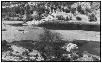
Figure 9.
Río de la Pasíon.
The town of Todos Santos, on the west side of the peninsula south of La Paz, has little marsh, but button mangrove first occurs at Las Piedritas to the south. This appears to be the northernmost extension of its range on the Pacific coast.[15]
The Sierra de la Laguna Range of the Cape Region extends almost north/south in direction, the drainages are east and west. The plant communities are oak/pinyon woodland above and semi-deciduous forest below. The Sierra de la Laguna weather station is in a meadow known as La Laguna. It is at approximately 1,900 m. elevation. Records indicate 350 mm. of rain falls in the summer months and about the same amount during the rest of the year. The average annual rainfall at the La Laguna station is 735 mm. (Hastings and Humphrey 1969).
The Sierra de la Laguna watershed empties into the tropical Pacific by several relatively straight canyons. None of the streams normally reach either the Gulf or the Pacific. The arroyos on the west scarp are precipitous and only carry water after rainfall. The larger and more gradual east-facing arroyos carry water much of the year and have considerable runoff during the summer months. There are subsistence farming or ranching operations on the lower slopes of the mountains, as well as in the arroyos.
Two of the largest arroyos have extensive drainages and pass through the towns of Santiago and Miraflores. Both streams are perennial in the mountains; even during periods of drought deep pools remain at the lower elevations. Both arroyos have bosques of willow (S . taxifolia ) along their courses. The beautiful "zalate", a fig (Ficus sp.), is common here.
The town of San José del Cabo (23°5'N) (fig. 10) at is at the middle of the peninsular tip. It overlooks the estuary and mouth of the broad valley through which the Río San José formerly flowed. The valley extends north for over 50 km. When Nelson visited the area there was extensive agriculture and a well-established town (Nelson 1922). The river no longer flows except during flood periods because of ever increasing agricultural and population demands. The valley has not suffered the damage of other areas because rainfall is sufficient to replenish the aquifers (Palacios 1978).
The Sierra de la Giganta range extends north roughly from Cerro Machado, a peak of 1,025 m. just north of Bahía La Paz (24°35'N) to about 30 km. northwest of Loreto (26°30'N). The

Figure 10.
San José del Cabo.
eastern escarpment of the Giganta range is precipitous and close to the Gulf. The western slopes decline more gradually to the Llano Magdalena.
There are several large mangrove lagoons on the west side of the Gulf between La Paz and Bahía de Los Angeles. Most of these areas have extensive salt marshes whose vegetative species include glasswort and saltwort. Bahía de La Paz (24°10'N) is well inside the Gulf of California and has the largest port on the Gulf side of the peninsula. Several areas in the bay have wetlands. Pichilingue in the outer bay has black, red and white mangrove at the lowest littoral zone. Saltwort dominates at higher elevations. Inside La Paz Bay and on the El Magote peninsula the same three mangroves are present, but glasswort replaces the saltwort at higher littoral zones.[15] The town of Loreto also has some mangrove and salt marsh vegetation.[16]
In the Sierra Giganta west of Loreto is an area known as Las Parras, a beautiful arroyo draining these mountains to the east. "Palma de taco" (Braheabrandegeei ), an endemic palm, is found in abundance here (Coyle and Roberts 1975).
Mulegé and Bahía Concepción to the immediate south are rimmed with mangroves. Río Mulegé, in Arroyo Santa Rosalea (26°05'N) is actually a brackish water lagoon. It exists for only 3 km., running from below a bridge and dam in the town to the Gulf. The river is navigable for small boats. It is surrounded by palms, both native Mexican fan palms (Washingtoniarobusta ) and introduced date palm. The wide valley, Arroyo Santa Rosalea, above Mulegé (fig. 11) has been under intensive cultivation for many years.
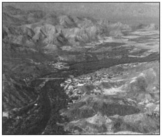
Figure 11.
Mulegé and Arroyo Santa Rosalea.
Río San José de Magdalena is one of the perennial streams in the Gulf drainage system. It is located just above 27°N. There is substantial subsistence farming in much of the arroyo and the willow overstory has been largely replaced by small agricultural plots. The stream disappears where the mouth of the canyon opens into the bajada leading to the Gulf. There is a large stand of the endemic "güéribo trees" (Populusbrandegeei ) in the arroyo above the town of San José de Magdalena. This is the northernmost population of this beautiful cottonwood species (Coyle and Roberts 1975). It is most common in the arroyos of the Cape, but a few trees are also found in the Sierra Giganta.
Farther north, San Lucas (27°30'N) has a relatively small bay, with red mangrove, black mangrove, and glasswort. There is also a Suaeda that resembles Suaeda californica but may be an undescribed species.[15]
Bahía de Los Angeles has a large salt marsh at te head of the bay with some red mangrove, also saltwort and glasswort. To the north, San Luís Gonzaga (29°42'N) has saltwort and glasswort in some areas of the bay.
With the exception of the California Region, the transition zones of vegetation over most of the peninsula are brief or absent in the riparian corridors. Species found in Desert Region transition zones include mesquite, palo verde, ironwood (Olneyatesota ), creoste bush (Larrea tridentata ), and lomboy (Jatropha spp.).
Much of the transition zone along both peninsular coasts is comprised of sand dunes or sea bluffs. The most common dune species in the northern and central sections of the west coast are sand verbena (Abroniamaritima ), ice plant (Mesembryanthemumchilense ) and sea purslane (Sesuviumverrocosum ) (Johnson 1973). Other coastal dune plants include species of Ambrosia , Oenothera , and Verbena . Sea bluff community plants are confined to the Pacific side of the peninsula. They include Dudleya spp., ice plant, marsh-rosemary (Limoniumcalifornicum ), and Eriophyllum spp. (Wiggins 1959, 1980).
From Todo Santos south, sand verbena, ice plant, and sea purslane are replaced by the tropical grasses, dropseed (Sporobolusvirginicus ) and Jouvea pilosa . These grasses continue on the Gulf side of the Cape where sea purslane is absent and sand verbena is only found in scattered patches.
Whither the Peninsula
When the first dozen Europeans arrived at Loreto in 1697, there were probably 40,000 aborigines living a rather precarious existence on the entire peninsula (Aschmann 1967). Baegert, a German Jesuit missionary, returned to Europe after 20 years in Baja California and spent the remaining four years of his life writing an excellent account of the peninsula (Baegert 1772). In Chapter VIII entitled "The Vermin of California" he wrote:
To this group belong the snakes, toads, bats, wasps, ants and locusts. Of the first named there are twenty different kinds in California, and every year thousands of them are buried in the stomachs of the California Indians (ibid .).
The entire peninsula of Baja California could apparently only support 40,000 Indians in bare subsistance. It is difficult to imagine how long this fragile landmass, two-thirds of it desert, will sustain the rapidly expanding population of 2.25 million and the concurrent development. Since 1940, the average rate of population growth for Tijuana alone has been over 9% per year (Navarro 1976).
Last year, Baja California Norte produced nearly 300,000 tons of agricultural crops and shipped 152,000 head of cattle.[18] During the entire missionary period, the southern half of the peninsula never supported more than 1,000 ha. of agricultural crops, most of which were raised adjacent to or in riparian systems (Palacios 1978).
Engineer Raul Palacios has provided the following critique of that situation:
It is estimated that from 1921 to 1930 the Magdalena plain of Baja California Sur did not cultivate more than 5,000 hectares. Cattle raising activity was more extensive. The limiting factor was water. At the present time, approximately 50,000 hectares are annually cultivated; in this same region, 600 wells are being used to furnish water.
Of the water removed by pumping from wells, 90.6% is coming from aquifers and only 9.3% is available from surface water. In all cases except the San José del Cabo region, this extraction is substantially higher than the new charge or recovery.
Due to over-exploitation, the resulting salt water intrusion, and new pumping areas, at least 100 wells will now have to be relocated farther away from the coast. The conception that underground waters are renewable resources must be changed by all means." (ibid .)
This headline appeared in the San Diego Union: NO WATER FOR 500,000 OF TIJUANA'S POOREST.
This city's antiquated water system and a sharp drop in reservoirs have left an estimated 500,000 of Tijuana's poorest residents without running water for two to six weeks. State officials said no water can be pumped to an estimated 80 affected neighborhoods until late 1982. That is when a new aqueduct from the Colorado River in Mexicali to Tijuana is scheduled to be completed.[19]
The California Region in the north has the greatest water resource potential, but it must be developed, and at prohibitive costs. At the present rate of growth in the north, it is doubtful that future water sources, including the new Colorado River aqueduct, will be capable of supplying the needs of the expanding population.
The northern mountain ranges and their riparian corridors have not yet suffered serious damage. Hydrologic development in the north, should it occur, will accelerate deterioration of the remaining riparian systems. The mid-peninsular Desert Region has no water available for development other than that supplied by depleting two fossil aquifers. The Vizcaíno Desert and the Magdalena Region will be forced to transport water from elsewhere or allow present agricultural projects to revert back to desert within a few years when the fossil aquifers are depleted. The Cape Region is growing less rapidly than the north and the government has not aggressively attempted to expand industry there.
[18] Annual Report of the Sec. de Desarrollo, Dir. de Agricultura y Ganaderia, annual report of the state. 1979–1980.
[19] San Diego Union. August 22, 1981.
The Mexican Government is attempting to exploit marine resources at an accelerating pace throughout the peninsula. In most areas, shellfish beds have been so severely depleted that conservation efforts may prove futile. As the ports of Bahía Magdalena are developed, increasing pressures will cause further deterioration of the natural resources of this enormous wetland. The philosophy of the Mexican Government is oriented towards development of resources, not their conservation.
Scientists and others involved in natural resources programs are consequently charged with investigating possibilities for exploitation. Basic research or even long-range research is severely limited in favor of attempts to provide food and shelter for the rapidly expanding population.
Conservation programs, if initiated at all, are generally underfunded and understaffed. In Mexico, as in most Latin American countries, there is a very limited political constituency for the management of natural resources at the present time. However, in recent years both the USDI Fish and Wildlife Service and the Office of Environmental Services of the U.S. State Department have been working with Mexican officials to develop conservation programs applicable to Mexico.
Literature Cited
Anderson, D.L. 1971. The San Andreas Fault. Scientific American 225(5): 52–68.
Aschmann, Homer. 1967. The central desert of Baja California: demography and ecology. p. 145–148. The Central Desert of Baja California: demography and ecology. Manessier Publshing Company, Riverside, Calif. 282 p.
Baegert, Johann Jakob. 1772. Observations in lower California. Second edition. Translated in 1952. University of California Press, Berkeley, California. 218 p.
Brown, David E. 1978. Southwestern wetlands—their classification and characteristics. p. 269–282. In : R.R. Johnson and J.F McCormick (tech. coord.). Strategies for protection and management of floodplain wetlands and other riparian ecosystems: proceedings of the symposium. [Callaway Gardens, Georgia, December 11–13, 1978]. USDA Forest Service GTR-WO-12. 410 p. Washington, D.C.
Carter, Annetta. 1980. The vegetation of the Sierra de la Giganta Baja California Sur: its scientific and potential economic importance. Presented at the eighteenth annual symposium of the Asociacion Cultural de Las Californias. [Loreto, Baja California Sur, Mexico, May, 1980]. 5 p.
Coyle, Jeanette, and Norman C. Roberts. 1975. A field guide to the common and interesting plants of Baja California. 206 p. Natural History Publishing Company, La Jolla, Calif.
Hastings, James R., and Robert R. Humphrey (ed.). 1969. Climatological data and statistics for Baja California. Technical report on meteorology and climatology of arid regions, No. 18. 85 p. University of Arizona, Tucson.
Hastings, J.R., and R.M. Turner. 1965. Seasonal precipitation regimes in Baja California, Mexico. Geografiska Annaler 47:204–223.
Humphrey, Robert R. 1974. The Boojum and its home. 214 p. University of Arizona Press, Tucson.
Johnson, Ann. 1973. A survey of the strand and dune vegetation along the Pacific coast of Baja California. Masters Thesis, University of California, Davis. 126 p.
Johnson, R. Roy. 1978. The lower Colorado River: a western system. p. 41–62. In : R.R. Johnson and J.F McCormick (tech. coord.). Strategies for protection and management of floodplain wetlands and other riparian ecosystems: proceedings of the symposium. [Callaway Gardens, Georgia, December 11–13, 1978]. USDA Forest Service GTR-WO-12. 410 p. Washington, D.C.
MacDonald, K.B., and M.G. Barbour. 1974. Beach and salt marsh vegetation of the North American Pacific coast. p. 175–233. In : R.J. Reimold and W.H. Queen. An ecology of Halophytes. 605 p. Academic Press, New York, N.Y.
Murphy, R.W. 1975. Two blind snakes (Serpentes: Leptotyphilopidae) from Baja California with a contribution to the biogeography of peninsular and insular herpetofauna. Proc. Calif. Acad. of Science series 4, 40:99–103.
Navarro, Gabriel Cuevas. 1976. Acueducto Rio Colorado-Tijuana, Baja California, Mexico. p. 3–22. In : J. Fernandez (ed.). Proceedings of XIV symposium of Baja California. [Tecate, Baja California, Mexico, May 1–2, 1976]. 59 p. Instituto de Investigaciones Esteticas de la U.N.A.M., Mexico.
Nelson, Edward W. 1922. Lower California and its natural resources. 194 p. Manessier Publishing Company, Riverside, Calif.
Neuenschwander, L.F., T.H. Thorsted, Jr., and R.J. Vogl. 1979. The salt marsh and transitional vegetation of Bahía de San Quintín. Bull. So. Calif. Acad. Sci. 78(3): 163–182.
Ohmart, R.D., W.O. Deason, C. Burke. 1977. A riparian case history: the Colorado River. p. 35–77. In : R.R. Johnson and D.A. Jones (ed.). Importance, preservation and management of riparian habitat: a symposium. [Tuscon, Arizona, July 9, 1977]. USDA Forest Service GTR-RM-43. 217 p. Rocky Mountain Range and Experiment Station, Fort Collins, Colorado.
Palacios, Raul Aviles. 1978. Evolution of the agriculture in south Californian desert. In : J.C. Agundez (ed.). Proceedings of the XVI Symposium de la Asociacion Cultural de las Californias. [San José del Cabo, Mexico, May 1978]. 254 p.
Rodriguez, Fernando. 1981. Baja California: its coast and highlands along the Sea of Cortez. p. C8–10. In : Kirchner, W.M. Mathes, D. Kerig, R. McFarlane (ed.). Proceedings of Baja California symposium XIX. [California State University, Los Angeles, May 16–17, 1981]. California State University, Los Angeles.
Savage, Jay M. 1959. Evolution of a peninsular herpetofauna. p. 184–212. In : J.S. Garth (ed.). Biogeography of Baja Califorina and adjacent seas: proceedings of the symposium. Part 3. [San Diego State College, San Diego, Calif., June 16–17, 1959]. 88 p. Society of Systemic Zoology, Washington, D.C.
Van Denburgh, John. 1922. Reptiles of western North America. 980 p. California Academy of Sciences, San Francisco.
Warner, Richard E. 1979. The California riparian study program: background information and proposed study design. 177 p. California Department of Fish and Game, Sacramento.
Welsh, Hartwell H., Jr. 1976. Ecogeographic distribution of herpetofauna of the Sierra de San Pedro Mártir region. Masters Thesis, California State University, Humboldt, Arcata, Calif. Unpublished. 169 p.
Wiggins, Ira L. 1959. The origin and relationships of the land flora. p. 148–165. In : J.S. Garth (ed.). Biogeography of Baja Califorina and adjacent seas: proceedings of the symposium. Part 3. [San Diego State College, San Diego, Calif., June 16–17, 1959]. 88 p. Society of Systemic Zoology, Washington, D.C.
Wiggins, Ira L. 1980. Flora of Baja California. 1025 p. Stanford University Press, Stanford, California.
Riparian Problems and Initiatives in the American Southwest
A Regional Perspective[1]
R. Roy Johnson and Lois T. Haight[2]
Abstract.—Southwestern riparian systems support some of the world's most endangered ecosystems. These rich riparian areas are high-energy zones, supporting some of the richest biotas in North America, as well as being in great demand for human use. Estimated losses of these natural ecosystems range from approximately 70% to more than 95%. Associated problems include wildlife and recreational losses as well as diminishing water quality.
Introduction
. . . For eons we dreamed of and labored toward escaping from the anxieties and hardships of a wilderness condition only to find, when we reached the promised land of supermarkets and air conditioners, that we had forfeited something of great value. (Nash 1978)
The southwestern United States is drained by two major river systems, the Colorado and the Rio Grande. Both rivers drain large areas, but flow levels are low due to sparse precipitation and high evaporation rates. The region is generally arid, except for some high montane areas and scarce riparian wetlands. Warm weather and accompanying long growing seasons permit production of semitropical crops and high-production food, forage, and fiber agribusinesses. Water withdrawal for irrigation, mining, municipal, and industrial uses results in heavy demands on both surface water supplies (streams and lakes) and groundwater reserves (aquifers). Little water reaches the Pacific Ocean from the Colorado or the Atlantic from the Rio Grande. Destruction of much of the Southwest's riparian zone is the result of two basic processes: 1) depletion of riverine waters by consumptive uses; and 2) mechanical damage from grazing, mining, and engineering activities associated with railroad and road building (Dobyns 1981), and more recently with suburban and urban developments.
Characteristics and Values of Southwestern Riparian Ecosystems
Recent investigations have demonstrated that southwestern riparian zones support some of the most productive ecosystems in North America (Johnson and Jones 1977; Johnson and McCormick 1978). Characteristics which contribute to the ecological richness of southwestern riparian ecosystems include the following.
1. As linear ecosystems, riparian systems provide a maximum amount of edge per unit area. The importance of this edge effect is discussed by Johnson (1978) and Odum (1978).
2. The ecotonal nature of riparian systems is due to their interfacing with adjacent aquatic and terrestrial ecosystems.
3. As islands of mesophytic and hydrophytic vegetation in the arid and semiarid West, riparian systems support a uniquely diverse fauna and flora. Western riparian ecosystems are high energy systems due in part to ". . . high water tables and alluvial soils from drainage and erosion of adjacent uplands on the one side, or from periodic flooding from aquatic ecosystems on the other" (McCormick 1978). As high-energy systems, riparian systems are in great demand by humans for recreation and by both wildlife and humans for food, water, dwelling sites, and a large variety of other uses.
Southwestern Riparian Systems
Endangered Ecosystems
Southwestern riparian/wetland zones support truly endangered ecosystems. This is especially true of riparian zones of the arid and semiarid lowlands. Johnson etal . (1977), for example, found that of 166 species of birds nesting in the southwest lowlands, 47% are entirely dependent, and an additional 30% partially dependent, on riparian and other wetlands. To date little
[1] Paper presented at the California Riparian Systems Conference. [University of California, Davis, September 17–19, 1981].
[2] R. Roy Johnson is Unit Leader and Lois T. Haight is Research Associate; both are with the Cooperative National Park Resources Studies Unit, USDI National Park Service, School of Renewable Natural Resources, University of Arizona, Tucson.
has been done to conserve the paltry remnants of our southwestern riparian ecosystems. Laws protecting riparian zones from destructive activities such as housing and business developments have been inadequate. A current strategy to protect prime riparian ecosystems is their purchase by groups such as The Nature Conservancy, Defenders of Wildlife, and the USDI Fish and Wildlife Service (FWS). Additional efforts in Arizona and New Mexico consist largely of attempts by governmental, scientific, and private groups to inventory and evaluate the miniscule remnants of what were often extensive riparian areas and to establish natural areas in what little remains (Smith 1974).
The overall result of riverine technological developments in the Southwest has been a diminished diversity of wildlife and vegetationtypes. This constant erosion of ecological diversity has in turn resulted in a lack of recreational opportunities and a downward trend in the quality of human life itself. This downward trend does not refer just to the niceties of life. It refers to more than whether a reservoir is to be built to provide speedboating and water-skiing, in place of canoeing, camping, picnicking, and bird-watching. The concern is for subsistence—life itself—food and water.
Still, growth continues unchecked and with a lack of water resource planning in large southwestern cities. Populations continue to expand while surface water and groundwater supplies diminish. An example of a pending crisis brought on by river mismanagement is the effects on fisheries and the food and recreation they provide. Several papers presented by Paulsen and co-investigators in a recent symposium on aquatic resources of the Colorado River point out problems along the Colorado itself. Here, the construction of Glen Canyon Dam has degraded the fishery of downstream Lake Mead, important as a recreational fishery. We are all familiar with estuarine losses from water pollution. Less, however, is known of the rapid degradation of the important marine fishery further downstream in the Gulf of Lower California. Little attempt has been made to determine the influence of gargantuan dams upstream on the Colorado. The reservoirs behind these dams serve as gigantic sinks, trapping nutrients which formerly flowed into the Gulf, thereby providing an important energy source for these fisheries. And, if the fishery has deteriorated, (that is, the higher trophic levels are in "poor health,") then so has the rest of the ecosystem, (that is, the lower trophic levels on which the fish depend). Much of these aquatic nutrients originated in the riparian zone (Meehan etal . 1977). These same reservoirs have an annual evaporation rate of approximately one million acre-feet (AF) of water, enough for four million people (van Hylckama 1971; Jassby 1980), from a system already over-allocated by more than two million AF per year (Dracup 1977). The Colorado River is little more than a series of reservoirs and canals from Lake Powell to its delta, more than 1,287 km. (800 mi.) downstream. Even the worldfamous Grand Canyon "whitewater" is at the mercy of Glen Canyon Dam releases. The Rio Grande has suffered a similar fate, with little more than 10% of its length flowing before the river is impounded.
Reclamation projects in the United States, instead of conserving water, may actually be "desertification projects." Sheridan (1981) recently wrote a treatise on "desertification," published by the US Council on Environmental Quality, which points out some startling commonalities between the results of many of our "reclamation projects" and the characteristics used to determine desertification. These characteristics include salinization of soil and water, diminishing groundwater supplies, high soil erosion, reduction of surface water, and loss of native vegetation. This technology of water salvage has misled us in two important ways. It has not provided an efficient, environmentally safe means of using our water resources and, in fact, has in the long run actually diminished the quality of our environment.
Riverine Management and the Status of Riparian Systems
In the same sense that riparian systems concentrate natural resources (e.g., energy, nutrients, plants, and animals), they also serve to concentrate cultural resources. This is true for agricultural, urban, and recreational factors. Unfortunately, in many cases the riparian characteristics which originally attracted humans are in turn destroyed by improper use and management. On the surface these management activities often sound respectable, even desirable or necessary. Many projects have led to the loss of riparian values and eventually even to desertification. Water management projects which have produced conditions resulting in desertification (ibid .) include reclamation, flood control, channelization, and phreatophyte control.
Primary, secondary, and even tertiary tributaries of major southwestern rivers have all been greatly affected by riverine management. The Gila-Salt-Verde River system is an example of a large riverine network which originally flowed into the Colorado. In the early 1900s, a series of storage dams was constructed on the three rivers. By the mid 1900s these rivers had been so greatly altered that less than one-half of the approximately 1600 km. (1000 mi.) of watercourse remained in a relatively free-flowing state. The remainder of the system had been converted to a series of storage reservoirs (above dams) and dry channels (below dams), greatly reducing the natural diversity of these riverine ecosystems. Today the Gila River flows into the Colorado River only during flood stage. In turn, water from the Colorado River is so heavily allocated that the last segment of this great river is dry, rarely debouching across its delta into the Gulf of Lower California.
Flood Control
The two basic means of flood control are a) construction of temporary holding reservoirs, and b) channelization. Each has advantages. The building of dams, often earth-filled and gravel types, has the advantage of requiring less maintenance than channelization. However, an interesting political problem has arisen recently with flood control dams in the Southwest, where water is such a scarce resource. Once floodwaters accumulate in the reservoir behind the dam, the local citizenry resists attempts to drain the reservoir in preparation for the next flood. Painted Rock Dam, on the Gila River near Gila Bend, is an example of this problem becoming a major local political issue. The draining of stored water represents a great resource loss to the people of arid areas, where water-based recreation such as fishing, water-skiing, boating, and swimming is at a premium. Orme Dam, a proposed dam associated with the Central Arizona Project, has been promoted by its backers as both a recreational and a flood control dam. The two uses are basically incompatible, for in order to fulfill their planned functions, reservoirs of flood control dams are best kept empty and those of recreational dams full.
Channelization has been advocated by numerous water salvage interests as a means of reducing vegetation, especially saltcedar, and thus allowing floodwaters to pass through an area with minimal damage. A major problem with the practice of channel clearing or ditching is continual expensive maintenance. Even worse, although it may reduce flooding in the area of channelization, the practice often increases flood damage downstream, since the floodwaters increase in velocity as they move through the channelized portion of the watercourse. Belt (1975) found that navigation works and levees caused significant rises in the stage of floods on the Mississippi and Missouri rivers. According to studies conducted on the Gila River and Tonto Creek, a tributary of the Salt River (Carothers and Johnson 1975), unchannelized areas supported approximately two to three times as many breeding bird species and individuals compared to channelized areas.
Phreatophyte Control
Many of the problems facing riparian systems today exist because the riparian zone has been so poorly understood. This may seem surprising for a widespread (but limited) zone of such great importance to both humans and wildlife. Until the 1970s, there was not a discipline which might be termed "riparian ecology." Up to that time, the term "phreatophyte" was often used, at least partially incorrectly, as a synonym for "riparian." As late as 1964, two well-known scientists, Campbell and Dick-Peddie (1964), published a paper in the prestigious journal Ecology entitled: "Comparison of phreatophyte communities on the Rio Grande in New Mexico." The paper is actually about riparian communities composed of a mixture of phreatophytes and non-phreatophytes.
Phreatophyte control has been one of the most damaging activities carried on by resource management agencies. Vegetation is usually removed from floodplains using chain saws or bulldozers, often in conjunction with stream channelization projects. Our own research findings indicate that removal of woody riparian vegetation drastically reduces wildlife usage of these disturbed areas. Proponents of these programs have suggested that phreatophyte removal may create open spaces, thereby increasing habitat diversity, and thus even improve wildlife values (Arnold 1972). On the contrary, our studies in the Verde Valley showed a linear relationship between the number of mature cottonwood trees per acre and the number of nesting birds (Carothers and Johnson 1971; Johnson 1971; Carothers etal ., 1974); thus, the fewer the trees, the fewer the birds.
Phreatophyte clearing (control) has taken a heavy toll on southwestern riparian forests. Babcock (1968) estimated that there were 113,000 ha. (279,000 ac.) of "phreatophyte" (riparian) vegetation in Arizona, while Ffolliott and Thorud (1974) estimated approximately 121,500 ha. (300,000 [280,000–320,000] ac.). This comprises less than 0.4% of the total land area in Arizona. Swift and Barclay (1980)[3] estimated that ". . . at least 70% of the original area of riparian ecosystems has been cleared . . ." in the United States. We estimate that less than 5% of the original riparian vegetation remains in the southwestern lowlands.
Historically, the Pacific Southwest Interagency Committee (of federal and state agencies) established a Phreatophyte Subcommittee in 1951. This subcommittee was especially concerned with the spread of saltcedar (Tamarixchinensis ) and associated problems (e.g., water usage through evapotranspiration [van Hylckama 1980] and clogging of river channels). The Subcommittee philosophy can be better understood by examining the proceedings of its third symposium, held in 1966, where only one of the eight papers addressed multiple-use values; the other seven being concerned only with water yield. Although early eradication programs were aimed largely at saltcedar, as time progressed more and more native riparian forests were also destroyed. In addition to the loss of shade and reduction in catchable fish (Stone 1970), high-value recreational sites apparently eroded more rapidly after the removal of trees (personal observation). Recent studies have shown that practices,
[3] Swift, B.L., and J.S. Barclay. 1980. Status of riparian ecosystems in the United States. Paper presented at 1980 American Water Resources Association National Conference, Minneapolis, Minn. 29 p. Unpublished manuscript. USDI Fish and Wildlife Service, Kearneysville, W. Va.
such as "phreatophyte control" and grazing, which degrade the natural riparian zone also commonly degrade associated aquatic ecosystems, including fisheries (Johnson and Jones 1977; Kennedy 1977; Cope 1979; Graul and Bissell 1978; Johnson and McCormick 1978; Boles and Dick-Peddie 1983). In addition to damaging and destroying riparian and aquatic ecosystems, it has not been shown that there is actually a net gain in water yield from areas where phreatophytes have been removed. Recent studies by USDI Geological Survey (GS) and other investigators on the Pecos River have failed to demonstrate increased river flows after removal of several thousand acres of saltcedar (Tamarix sp.).[4] Thus, phreatophyte control, like channelization, is a dubious method of flood control at best. In addition, these practices reduce plant and animal diversity in the riparian zone.
The year 1968, which appears so often in phreatophyte publications, is more than happenstance. This was the year during which activities peaked in phreatophyte control research, publications, and application. By 1970, only two years later, a drastic change in public attitude resulted in the following:
1) increased conservation activities in regard to rivers, culminating in the Sierra Club's fight with and victory over the Bureau of Reclamation (BR) in 1966, thereby preventing the construction of Marble Canyon and Bridge Canyon Dam on the Colorado River in Grand Canyon (Nash 1978);
2) a series of environmental laws and executive orders affecting riverine management including: a) the Wilderness Act of 1964; b) the Federal Water Project Recreation Act of 1965; c) the Wild and Scenic Rivers Act of 1968; and d) the National Environmental Policy Act (NEPA) of 1969; and
3) a growing body of knowledge regarding the values of riparian (phreatophyte) habitat to wildlife, water quality, and recreational activities. For example, the fact that southwestern riparian habitats support the highest density of noncolonial nesting birds in the United States was first presented by Carothers and Johnson at the annual American Ornithologists Union meeting in Fayetteville, Arkansas in 1969. The information was later published (Carothers etal . 1974).
In 1968, the Twelfth Annuual Arizona Watershed Symposium featured a panel entitled "Phreatophyte Control Pro and Con." This was a definite change from past symposia where papers were almost all pro control. The paper on wildlife values was presented by Bristow (1968), now Director of the Arizona Game and Fish Department and an early leader in "wildlife rights for phreatophytes." Subsequent symposia often contained papers which discussed other watershed values in addition to water yield.
By 1970, the word phreatophyte was considered problematic enough that the Pacific Southwest Interagency Committee changed the name of its Phreatophyte Subcommittee to Vegetation Management Subcommittee, as though closing out the chapter on single-use value in watershed management.
Riparian Ecology—A New Discipline
At first glance it might seem contradictory that a science dealing with riparian systems would originate in the arid Southwest. But water resources, like gold, are most appreciated where they are scarcest. Thus, the rapid if belated growth of riparian ecology in the Southwest as one of the newest of the environment sciences is not as irregular as it might seem. It was here that early authors (Austin and Bradley 1971) first used the terms "stream riparian" and "desert riparian" (Lowe 1964) to differentiate between riparian system types. For example, cottonwood/willow is associated with flowing or intermittent streams, while mesquite/desert willow is associated with ephemeral watercourses.
Western riparian ecosystems differ strikingly from their eastern counterparts. The presence of water, scant though it might be, creates conditions that contrast sharply with those of the surrounding arid and semi-arid uplands. Because of this obvious, visible difference, a different terminology has developed from bottomland hardwoods, swamp forests, and similarly named eastern wetland types.
Previously, only a few scattered studies had addressed specific problems in riparian systems. The importance of these riparian areas had been recognized earlier, often in theses and dissertations (e.g., Arnold 1940; Beidleman 1948, 1954). Some of these early studies related to the bottomland hardwoods, or floodplains, of the eastern deciduous hardwood forests. An early outstanding treatment of these floodplain forests was presented in a chapter by Shelford (1963) in his book "The Ecology of North America." Shelford and others, such as Everitt (1968), were especially concerned with successional processes along streams and the associated plant species and communities. Most of these earlier riverine studies were conducted in the East, a few of them in the Great Plains of the Midwest. However, no attempt had been made to amalgamate these studies into a unified discipline.
By the late 1960s, a new focal point was evolving in the Southwest. Here, where water is a primary limiting factor, studies first focussed on phreatophytes and evapotranspiration. Although phreatophytes are not limited to riparian systems, they commonly occur along watercourses and around springs and lakes. A data base, meth-
[4] Personal conversation with investigators.
odology, literature, and terminology for riparian entities other than phreatophytes developed rapidly during the 1970s.
In 1974, Carothers etal . published a definitive paper dealing with the importance of southwestern riparian habitat to nesting birds. The conclusions in this paper were based on studies begun in 1969 (Carothers and Johnson 1971), which demonstrated that the highest concentrations of noncolonial nesting birds in North America occurred in cottonwood forests along western perennial streams (Johnson 1971). In addition to the fact that a large majority of the southwestern nesting lowland avifauna is dependent on perennial and intermittent riparian habitat, Raitt and Maze (1968) had earlier pointed out the vital importance of desert watercourses (arroyos) to nesting birds in creosotebush desert. Hensley (1954) had even earlier called attention to the importance of desert washes in Organ Pipe Cactus National Monument to nesting and migrating birds.
Although Carothers and Johnson's papers in the early 1970s provided the first published, scientifically documented proof of the importance of riparian systems to wildlife populations, numerous papers published since these early studies have reinforced those original findings (Johnson and Jones 1977, Johnson and McCormick 1978). While early studies documented the importance of these riparian ecosystems to birds, more recent studies suggest riparian systems are equally important to mammals, other vertebrates, and flowering plants. In addition, since a large percentage of southwestern riparian birds are insectivorous, it can be assumed that insect productivity is also very high in riparian systems (Stevens 1976).
Emerging Trends in Riparian Conservation
National Efforts
After decades of decimating riparian ecosystems, there are now good indications of a growing awareness of riparian values. Attempts are being made by some management agencies to lessen or prevent further destruction. A series of position papers addressing riparian issues was presented by several federal agencies concerned with riverine resource management in the Southwest at the first national riparian symposium (Johnson and McCormick 1978). These agencies included the US Environmental Protection Agency, USDA Forest Service, FWS, USDI Soil Conservation Service, and USDI Bureau of Land Management. In addition, papers were presented which discussed projects being conducted by other agencies involved in riparian resource management, including the US Army Corps of Engineers, BR, US Council on Environmental Quality, GS, National Recreation Service, Office of Water Research and Technology, Science and Education Administration, and Tennessee Valley Authority. All of these federal agencies were cosponsors of the symposium, along with 10 private organizations including the American Forestry Association, Conservation Foundation, Environmental Law Institute, National Parks and Conservation Association, Nature Conservancy, National Wetlands Technical Council, Sport Fishing Institute, Oak Ridge Associated Universities, Wildlife Society, and Wildlife Management Institute.
Several projects, which have included local, state, and federal government and private organizations, have addressed the general problem of the demise of Southwestern riparian ecosytems. Foremost among those attempting to lessen riparian damages are several sections of FWS. Projects have included an unsuccessful attempt to develop a western riparian program. The results were an excellent draft by Robert Hays of the Western Energy and Land Use Team. His 63-page draft program was never initiated.
The efforts of the Eastern Energy and Land Use Team (EELUT), Kearneysville, West Virginia to develop a riparian program were also unsuccessful. However, efforts of this group resulted in outstanding synthesis draft manuscripts by Mark M. Brinson, Reubin Plantico, Bryan L. Swift, and John S. Barclay; a workshop by EELUT resulted in an important position paper (Warner 1979). Some of these scientists—e.g., Brinson and Barclay—are cooperators from academic ranks. EELUT has recently been dismantled. So far these programs have been thwarted due to a lack of money and manpower. This lack is due largely to political maneuvering, since the "riparian movement" is considered by some to be competitive rather than complementary to the FWS National Wetlands program.
State and Local Programs
Several state and local programs have emphasized the protection and proper management of riparian ecosystems. The Arizona Natural Areas Program, a joint program of the Arizona Academy of Science and the Arizona Department of Planning and Development, was begun in 1973. The purpose of this program was to recommend outstanding natural areas in Arizona for protection for their research, educational, recreational, aesthetic, biotic, geologic, archaeologic, and other values (Bergthold 1978, Bergthold and Johnson 1980). A majority of these designated and suggested natural areas include riparian ecosystems.
Today this umbrella program involves coordinators from the Arizona State Parks, and Game and Fish departments, a Natural Areas Advisory Council appointed by the Arizona-Nevada Academy of Science, and a cooperative program between The Nature Conservancy and the state. In addition to encouraging landowners to properly mangage riparian zones, the program advises utility companies and highway and other construction groups on whether planned or existing projects may be detrimental to outstanding natural areas.
Another example of a cooperative program was undertaken in the Lower Gila River Valley, New Mexico by six state and federal agencies (Hubbard
1977). This project also included investigations by numerous scientists from research and educational institutions. The project was instrumental in establishing the outstanding biological importance of the Lower Gila River Valley. Interest generated by the information from the investigations led to the purchase of riparian lands by The Nature Conservancy and continuing efforts to establish a wildlife preserve.
A final example consists of a study along the San Pedro River, a tributary of the Gila River. The Office of Arid Land Studies, University of Arizona, financed by The Nature Conservancy, examined the feasibility of purchasing riparian areas along the San Pedro River. Negotiations to acquire and protect some of the outstanding riparian areas along the San Pedro River are continuing.
Numerous other activities have been conducted by groups concerned with riparian wetlands. A few which bear mentioning include: a FWS project along the Verde River where Orme Dam may be built for the Central Arizona Project (McNatt etal . 1980); a program for fencing riparian vegetation to exclude grazing along the Salt and Verde rivers (USDA Forest Service 1979); attempts to organize programs designed to prevent urban, suburban, and rural developments in floodplains and riparian zones (Kusler 1979; Clark 1980). Growing concern is being expressed by other agencies. The US Council on Environmental Quality (1978) stated in its ninth annual report "No ecosystem is more essential to the survival of the nation's fish and wildlife." The National Park Service, noted for its protection of outstanding natural areas, has conducted extensive research on riparian lands under its jurisdiction (Carothers etal . 1976; Schmidly and Ditton 1978; Johnson 1981; Carothers and Johnson 1983). Recent synopses regarding values and problems in riparian ecosystems have been prepared by the USDA Forest Service (Waldrip and Malespin 1979; Crumpacker etal .;[5] Johnson and Carothers 1982), the FWS (Swift and Barclay[3] ), and even private organizations (American Fisheries Society 1980).
Much remains to be done. Numerous instances of unnecessary riparian destruction continue. Often they are the result of activities—or lack of preventative action—by the very agencies which are entrusted with the management of these important systems. Only by an increase in active, scientifically based management will we succeed in leaving even a viable remnant of Southwestern riparian ecosystems for posterity.
Acknowledgments
Thanks are due Lupe P. Hendrickson for editing and typing the manuscript. Bryan T. Brown, Kenneth J. Kingsley, and James M. Simpson aided in gathering information.
Literature Cited
American Fisheries Society, Western Division. 1980. Management and protection of western riparian stream ecosystems. 24 p.
Arnold, J.F. 1972. Ecology and management of riparian vegetation (abstract only). J. Ariz. Acad. Sci. (Proc. Suppl. 16th Ann. Meeting) 7:20.
Arnold, L.W. 1940. An ecological study of the vertebrate animals of the mesquite forest. M.S. Thesis, University of Arizona, Tucson. 79 p.
Austin, G.T., and W.G. Bradley. 1971. The avifauna of Clark County, Nevada. J. Ariz. Acad. Sci. 6(4):238–303.
Babcock, H.M. 1968. The phreatophyte problem in Arizona. p. 34–36. In : Twelfth annual Arizona watershed symposium. 49 p. Arizona State Lands Department, Phoenix.
Beidleman, R.G. 1948. The vertebrate ecology of a Colorado Plains cottonwood river bottom. M.S. Thesis, University of Colorado, Boulder. 351 p.
Beidleman, R.G. 1954. The cottonwood riverbottom as a vertebrate habitat. Ph.D. Thesis, University of Colorado, Boulder. 358 p.
Belt, C.B., Jr. 1975. The 1973 flood and man's constriction of the Mississippi River. Science 189:681–684.
Bergthold, P.M. 1978. Arizona State Park's Natural Area Program. p. 243–247. In : R.R. Johnson and J.F. McCormick (tech. coord.). Strategies for the protection and management of floodplain wetlands and other riparian ecosystems: Proceedings of the symposium. [Callaway Gardens, Georgia, December 11–13, 1978]. USDA Forest Service GTR-WO-12, Washington, D.C. 410 p.
Bergthold, P.M., and R.R. Johnson. 1980. The relationship of natural areas on National Park lands to other natural areas. Proc. 2nd Conf. Sci. Res. in the Natl. Parks: Ecosystem Studies. Natl. Park Serv., Washington, D.C. 4:323–329.
Boles, P.H., and W.A. Dick-Peddie. 1983. Woody riparian vegetation patterns on a segment of the Mimbres River in southwestern New Mexico. SW. Nat. 28(1):81–87.
[5] Crumpacker, D.W., R. Roy Johnson, James O. Klemmedson, Paul A. Rechard, Robert G. Woodmansee. Effects of livestock grazing on resource values of western riparian ecosystems. 57 p. Unpublished manuscript.
Bristow, B. 1968. Statement by Arizona Game and Fish Department of phreatophyte clearing project. p. 41–44. In : Twelfth annual Arizona watershed symposium. 49 p. Arizona State Lands Department, Phoenix.
Campbell, C.J., and W.A. Dick-Peddie. 1964. Comparison of phreatophyte communities on the Rio Grande in New Mexico. Ecology 45:492–502.
Carothers, S.W., and R.R. Johnson. 1971. A summary of the Verde Valley breeding bird survey. Project FW-16-10, Land and Water Project Investigations. 20 p. Arizona Game and Fish Department, Phoenix, Ariz.
Carothers, S.W., and R.R. Johnson. 1975. The effects of stream channel modification on birds in the southwestern United States. p. 60–76. In : R.V. Corning etal . (ed.). Stream Channel Modification: Proceedings of the symposium. [Harrisonburg, Virginia, August 15–17, 1975.] 172 p. Rt. 1, Box 312, Grottoes, Va.
Carothers, S.W., and R.R. Johnson. 1983. Status of the Colorado ecosystem in Grand Canyon National Park and Glen Canyon National Recreation Area. p. 139–160. In : V.D. Adams, and V.A. Lamarra (ed.). Aquatic resources management of the Colorado River ecosystem: Proceedings of the symposium. [Las Vegas, Nevada, November 6–18, 1981.] 697 p. Ann Arbor Science, Ann Arbor, Mich.
Carothers, S.W., R.R. Johnson, and S.W. Aitchison. 1974. Population structure and social organization of southwestern riparian birds. Amer. Zool. 14:97–108.
Carothers, S.W., Stewart W. Aitchison, Marin M. Karpiscak, George A. Ruffner, N. Joseph Sharber, Philip L. Shoemaker, Lawrence E. Stevens, Michael E. Theroux, and Dennis S. Tomko. 1976. An ecological survey of the riparian zone of the Colorado River between Lees Ferry and the Grand Wash Cliffs, Arizona. Colorado River Technical Report No. 10, Grand Canyon National Park, Ariz. 251 p.
Clark, J. (project director). 1980. Coastal environmental management. Guidelines for conservation of resources and protection against storm hazards. 161 p. The Conservation Foundation, Washington, D.C.
Cope, O.B. (ed.). 1979. Grazing and riparian/stream ecosystems: proceedings of the forum. 94 p. Trout Unlimited Inc., Denver, Colo.
Dobyns, H.F. 1981. From fire to flood: Historic human destruction of Sonoran Desert riverine oases. 222 p. Ballena Press, Socorro, N.M.
Dracup, J.A. 1977. Impact on the Colorado River basin and southwest water supply. p. 121–132. In : J. Wallis (ed.). Climate, climatic change, and water supply. National Academy of Science, Washington, D.C.
Everitt, B.L. 1968. Use of the cottonwood in an investigation of the recent history of a flood plain. Amer. J. Sci. 266:417–439.
Ffolliott, P.F., and D.B. Thorud. 1974. Vegetation management for increased water yield in Arizona. Agricultural Experiment Station Bulletin 215. University of Arizona, Tucson. 38 p.
Graul, W.D., and S.J. Bissell (tech. coord.). 1978. Lowland river and stream habitat in Colorado: A symposium. [Greeley, Colorado, October 4–5, 1978.] 195 p. Colorado Chapter of the Wildlife Society and Colorado Audubon Council.
Hensley, M.M. 1954. Ecological relations of the breeding bird population of the desert biome in Arizona. Ecol. Monog. 24(2):185–207.
Hubbard, J.P. 1977. A biological inventory of the Lower Gila River Valley, New Mexico. 56 p. New Mexico Department of Game and Fish, Santa Fe.
Jassby, A.D. 1980. The environmental effects of hydroelectric power development. p. 32–43. In : Study of nuclear and alternative energy systems. Supporting paper 8: Energy and the fate of ecosystems. Rpt. Ecosystems Impact Res. Group. Risk and Impact Panel, Comm. Nuclear and Alt. Energy Sys. Natl. Res. Council, Natl. Acad. Press. Wash., D.C.
Johnson, R.R. 1971. Tree removal along southwestern rivers and effects on associated organisms. Amer. Phil. Soc. Yearbook 1970: 321–322.
Johnson, R.R. 1978. The lower Colorado River: a western system. p. 41–55. In : R.R. Johnson and J.F. McCormick (tech. coord.). Strategies for the protection and management of floodplain wetlands and other riparian ecosystems: proceedings of the symposium. [Callaway Gardens, Georgia, December 11–13, 1978]. USDA Forest Service GTR-WO-12. Washington, D.C. 410 p.
Johnson, R.R. 1981. Riparian resources and endangered ecosystems. Pac. Park Sci. 1(3): 1–2.
Johnson, R.R., and S.W. Carothers. 1982. Southwestern riparian habitats and recreation: interrelationships and impacts in the Southwest and Rocky Mountain Region. Eisenhower Consortium Bull. 12, USDA Forest Service Rocky Mountain Forest and Range Experiment Station, Fort Collins, Colo. 31 p.
Johnson, R.R., and D.A. Jones (tech. coord.). 1977. Importance, preservation, and management of riparian habitat: a symposium. [July 9, 1977, Tucson, Arizona.] USDA Forest Service GTR-RM-43. Rocky Mountain Forest and Range Experiment Station, Fort Collins, Colo. 217 p.
Johnson, R.R., and J.F. McCormick (tech. coord.). 1978. Strategies for the protection and management of floodplain wetlands and other riparian ecosystems: proceedings of the symposium. [Callaway Gardens, Georgia, December 11–13, 1978]. USDA Forest Service GTR-WO-12. Washington, D.C. 410 p.
Johnson, R.R., L.T. Haight, and J.M. Simpson. 1977. Endangered species vs. endangered habitats: a concept. p. 68–79. In : Johnson, R.R., and D.A. Jones (tech. coord.). 1977. Importance, preservation, and management of riparian habitat: a symposium. [July 9, 1977, Tucson, Arizona.] USDA Forest Service GTR-RM-43, Rocky Mountain Forest and Range Experiment Station, Fort Collins, Colo. 217 p.
Kennedy, C.K. 1977. Wildlife conflicts in riparian management: water. p. 52–85. In : Johnson, R.R., and D.A. Jones (tech. coord.). 1977. Importance, preservation, and management of riparian habitat: a symposium. [July 9, 1977, Tucson, Arizona.] USDA Forest Service GTR-RM-43. Rocky Mountain Forest and Range Experiment Station, Fort Collins, Colo. 217 p.
Kusler, J.A. 1979. Consultants' report. Summary: emerging issues in wetland/floodplain management. Report of a technical seminar, US Water Resources Council, Washington, D.C. 41 p.
Lowe, C.H. (ed.). 1964. The vertebrates of Arizona. 270 p. University of Arizona Press, Tucson.
McCormick, J.F. 1978. A summary of the National Riparian Symposium: a proposal for a national riparian program. p. 362–363. In : R.R. Johnson and J.F. McCormick (tech. coord.). Strategies for the protection and management of floodplain wetlands and other riparian ecosystems: proceedings of the symposium. [Callaway Gardens, Georgia, December 11–13, 1978]. USDA Forest Service GTRWO-12. Washington, D.C. 410 p.
McNatt, R., R.J. Hallock, and A.W. Anderson. 1980. Riparian habitat and instream flow studies, lower Verde River: Fort McDowell Reservation, Arizona. Riparian Habitat Anal. Grp, USDI Fish and Wildlife Service, Albuquerque, N.M. 52 p.
Meehan, W.R., F.J. Swanson, and J.R. Sedell. 1977. Influences of riparian vegetation on aquatic ecosystems with particular reference to salmonid fishes and their food supply. p. 137–145. In : R.R. Johnson and D.A. Jones (tech. coord.). Importance, preservation, and management of riparian habitat: proceedings of the symposium. [July 9, 1977, Tucson, Arizona.] USDA Forest Service GTR-RM-43. 217 p. Rocky Mountain Forest and Range Experiment Station, Fort Collins, Colo.
Nash, R. 1978. Who loves a swamp? p. 149–156. In : R.R. Johnson and J.F. McCormick (tech. coord.). Strategies for the protection and management of floodplain wetlands and other riparian ecosystems: proceedings of the symposium. [Callaway Gardens, Georgia, December 11–13, 1978.] USDA Forest Service GTR-WO-12, Washington, D.C. 410 p.
Odum, E.P. 1978. Opening address: ecological importance of the riparian zone. p. 204. In : R.R. Johnson and J.F. McCormick (tech. coord.). Strategies for the protection and management of floodplain wetlands and other riparian ecosystems: proceedings of the symposium. [Callaway Gardens, Georgia, December 11–13, 1978]. USDA Forest Service GTR-WO-12. Washington, D.C. 410 p.
Raitt, R.J., and R.L. Maze. 1968. Densities and species composition of breeding birds of a creosotebush community in southern New Mexico. Condor 70:193–205.
Schmidly, D.J., and R.B. Ditton. 1978. Relating human activities and biological resources in riparian habitats of western Texas. p. 107–116. In : R.R. Johnson and J.F. McCormick (tech. coord.). Strategies for the protection and management of floodplain wetlands and other riparian ecosystems: proceedings of the symposium. [Callaway Gardens, Georgia, December 11–13, 1978]. USDA Forest Service GTR-WO-12. Washington, D.C. 410 p.
Shelford, V.E. 1963. The ecology of North America. 610 p. University of Illinois Press, Urbana.
Sheridan, D. 1981. Desertificaion of the United states. 142 p. US Council on Environmental Quality, Washington, D.C.
Smith, E.L. 1974. Established natural areas for Arizona. 300 p. Arizona Academy of Science and Arizona Office of Economic Planning and Development, Phoenix.
Stevens, L.E. 1976. Insect production of native and introduced dominant plant species. p. 129–135. In : S.W. Carothers, S.W. Aitchison, M.M. Karpiscak, G.A. Ruffner, N.J. Sharber, P.L. Shoemaker, L.E. Stevens, M.E. Theroux, and D.S. Tomko. 1976. An ecological survey of the riparian zone of the Colorado River between Lees Ferry and the Grand Wash Cliffs, Arizona. Colorado River Technical Report No. 10. 251 p. Grand Canyon National Park, Ariz.
Stone, J.L. 1970. Cottonwood clearance program on the Verde River and its tributaries. Completion report, FW16-10, Fisheries Eval. of Salt River Proj. 6 p. Arizona Game and Fish Department, Phoenix.
U.S. Council on Environmental Quality. 1978. Environmental Quality. Ninth Annual Report. 599 p. U.S. Council on Environmental Quality, Washington, D.C.
USDA Forest Service. 1979. Action program for resolution of livestock-riparian conflicts on the Salt River and Verde River. 129 p. Region Three, Arizona, Tonto, Prescott and Coconino National Forest. Albuquerque, N.M.
van Hylckama, T.E.A. 1971. Water resources. p. 135–155. Sinauer Associates, Stanford, Conn.
van Hylckama, T.E.A. 1980. Weather and evapotranspiration studies in a saltcedar thicket, Arizona. USDI Geological Survey Paper 491-F. 78 p. US Government Printing Office, Washington, D.C.
Waldrip, G., and M. Malespin. 1979. The importance of riparian habitats and their management of wildlife and fisheries: a current resumé of knowledge. 28 p. USDA Forest Service, Intermountain Region.
Warner, R.E. 1979. Proceedings of a workshop on fish and wildlife resource needs in riparian ecosystems. Natl. Water Res. Anal. Grp. Eastern Energy and Land Use Team. USDI Fish and Wildlife Service. 53 p.
Regional Riparian Research and a Multi-University Approach to the Special Problem of Livestock Grazing in the Rocky Mountains and Great Plains[1]
David W. Crumpacker[2]
Abstract.—A selected survey of Rocky Mountain/Great Plains riparian research with emphasis on livestock grazing impacts and management is presented. A multiuniversity plan for studying interactions between livestock grazing and riparian resources in the region is presented. The power of an integrated, regionwide approach is compared with that of one involving the conduct of numerous independent, site-specific studies. An analogy is made to California, considering the State as a region. The need for support of long-term riparian research by traditional academic funding sources is also stressed.
Introduction
This report is meant to serve three purposes: 1) provide a Rocky Mountain and Great Plains regional perspective on riparian research to complement similar reports at this conference on the American Southwest and Intermountain Region; 2) discuss relationships between livestock grazing and riparian resources; and 3) describe a regional, multi-university approach to riparian research.
Status and Value of Western U.S. Riparian Ecosystems
Recent estimates indicate that 70–90% of the natural riparian ecosystems in the United States have been lost to human activities (US Council on Environmental Quality 1978; Warner 1979a; Swift and Barclay[3] ). Losses have been estimated at 98.5% in the Sacramento Valley of California (Smith 1980) and 95% or more in Arizona (Warner 1979b). In the Rocky Mountain/Great Plains region Johnson and Carothers (1981) believe that 90–95% of the cottonwood/willow riparian ecosystems of the plains and lower foothills have been lost. Beidleman (1978) has stated that this is unquestionably the most productive and highly diversified ecosystem type in the Rocky Mountains and Great Plains. Perhaps 80% of the publicly and privately owned riparian areas that still exist in the United States are in an unsatisfactory condition or are dominated by human activities (Almand and Krohn 1978; Warner 1979b).
Western U.S. riparian ecosystems contain disproportionately great concentrations of wildlife species and populations compared to adjacent uplands. This has been well documented in the American Southwest (Davis 1977; Johnson 1971; Johnson and Carothers 1975; Johnson, Haight and Simpson 1977; Stevens etal . 1977) and the Pacific Northwest (see discussion and references cited in Thomas, Maser and Rodiek 1979). The situation is similar in the Rocky Mountains
[1] Paper presented at the California Riparian Systems Conference. [University of California, Davis, September 17–19, 1981].
[2] David W. Crumpacker is Professor of Environmental, Population and Organismic Biology, University of Colorado, Boulder, Colo. He is also President-Elect of the Eisenhower Consortium for Western Environmental Forestry Research which has its main office at 240 W. Prospect St., Fort Collins, Colo.
[3] Swift, B.L. and J.S. Barclay. 1980. Status of riparian ecosystems in the United States. Unpublished manuscript. 29 p. USDI Fish and Wildlife Service, Kearneysville, W. Va. [Prepared for presentation at the 1980 American Water Resources Association National Conference, Minneapolis, Minn.] Cited in Johnson, R. Roy and Steven W. Carothers. 1981. Southwestern riparian habitats and recreation: interrelationships and impacts in the Rocky Mountain Region. Eisenhower Consortium Bulletin. [In press]. USDA Forest Service, Rocky Mountain Forest and Range Experiment Station, Fort Collins, Colo.
and Great Plains. Beidleman (1978) estimated very conservatively that the cottonwood/willow ecosystem type contains at least 40% of the vertebrate species found in that region. The South Platte River Valley of northeastern Colorado in Weld and Morgan Counties has 151 vertebrate species of which 147 (97%) make at least seasonal use of the riparian and associated aquatic zones (Fitzgerald 1978). The mixed cottonwood/willow community type has the most species of birds and mammals, whereas the openpark, open-cottonwood, and aquatic types have the most reptilian and amphibian species (Fitzgerald 1978). The native trees and shrubs in the moist hardwood draws of northern plains grasslands comprise less than 1% of the regional ecosystems, but are believed to provide valuable, and possibly critical, wildlife habitat (Boldt, Uresk, and Severson 1978).
Livestock Grazing and Riparian Resources
Impacts
Livestock grazing is the most pervasive land use in the western United States. Eighty-three percent of the 11 conterminous western states is in forest and range and much of this is grazed by livestock. Nationwide, it has been estimated that 70% of the forests and rangelands are grazed (Platts 1979). Cattle derive great value from western riparian ecosystems. They strongly prefer them for a number of reasons (Ames 1977), the most important of which is access to water. This preference increases as summer progresses and the adjacent upland vegetation becomes depleted or desiccated (Dahlem 1979; Martin 1979).
The major direct impacts of livestock grazing are on vegetation and soils. This can cause severe indirect effects on wildlife. Grazing for only a few days or weeks has sometimes been observed to cause serious damage to woody regeneration (Ames 1977; Duff 1979). Extensive grazing can lead to virtually no reproduction of trees and a decadent riparian forest. If too much protective ground cover is removed, the soil becomes compacted, infiltration of precipitation decreases, and erosion of topsoil into the aquatic zone occurs (Moore etal . 1979; Thomas, Maser and Rodiek 1979; Platts 1979). Major detrimental effects to trout habitats and populations can then occur (Behnke and Raleigh 1978). Excessive use of the riparian zone by livestock also lowers its commercial grazing value. Soil compaction by trampling tends to favor shallow-rooted, herbaceous perennials or tap-rooted perennial shrubs in place of fibrous-rooted plants which are usually more palatable, nutritious and dependable on a yearround basis (Platts 1979).
Recovery under Livestock Exclosure or Withdrawal
Numerous observations on recovery of riparian and aquatic ecosystems following complete exclusion of livestock have been reported in recent years. Many of the observations involved unreplicated comparisons and none included statistical analyses of the results. Nevertheless, the combined weight of this evidence suggests that there is considerable resilience in western U.S. riparian and aquatic systems. Platts (1979) and Keller, Anderson and Tappel (1979) reviewed a number of these studies that focused on streams and fisheries. Moderate to large percentage improvements were observed in riparian vegetation, streambank stability, channel morphology, substrate, water temperature, and trout number and biomass. A period of up to five years may be needed for reasonable recovery of an aquatic system, following removal of livestock (Behnke and Raleigh 1978; Moore etal . 1979; Skovlin[4] ).
Some information is also available on the response of riparian trees and shrubs following livestock exclosure. Glinski (1977) observed large increases in cottonwood regeneration in an area of relatively abundant water and long growing season in southeastern Arizona, following eight years of exclosure. Davis (1977) has observed that young cottonwood, alder, and sycamore can grow 3–4.6 m. (10–15 ft.) in a few years in the American Southwest if protected from grazing. Crouch (1978) noted a doubling of woody understory in a cottonwood/willow community along the South Platte River in northeast Colorado, after seven years of exclosure. No further increases were observed during 18 additional years. Although the number of cottonwoods decreased in both the grazed and ungrazed areas that Crouch studied, the decline was 38% less for the ungrazed area. (The decline in the ungrazed area was attributed to other factors, one of the most important being managed stream flows which are detrimental to cottonwood germination and establishment.) A literature survey by Skovlin[4] led him to suggest that five to eight years may be required for acceptable recovery of riparian shrubs in most areas. A high-altitude willow community at 2650 m. in the North Park region of north central Colorado (46 frost-free days) was observed by Knopf and Cannon (1981) to recover at a slow rate following removal from chronic, heavy grazing pressure. They noted that their results lend quantitative support to Myers' estimate (1981) that: a) 10 to 12 years may be insufficient time for a southwestern Montana willow community to recover from prolonged, excessive grazing; and b) it is more difficult to improve a damaged riparian ecosystem by removing it from grazing than it is to maintain a good one while grazing it. These various observations suggest that riparian ecosystems do not undergo
[4] Skovlin. Impacts of grazing on wetlands and riparian habitat—the state of our knowledge. Unpublished draft manuscript, presented at National Academy of Sciences/National Research Council workshop: Impacts of grazing intensity and specialized grazing systems on use and value of rangelands. [March 16–17, 1981, El Paso, Tex.].
general recovery from overgrazing as rapidly as their aquatic counterparts, particularly in regions with short growing seasons.
Grazing Management Options
A number of grazing management options have been suggested for riparian/aquatic systems by wildlife and fishery researchers and managers (e.g. Behnke and Raleigh 1978; Benson 1979; Moore etal . 1979; Skovlin;[4] Storch 1979). These include alternatives such as the following: complete exclosure from grazing; management as a separate pasture in a grazing system; tailoring the management to specific flora, conditions, etc.; location of watering, salt, and supplement sites away from the riparian zone; intensive herding; reduction of stocking rates; seasonal deferments and/or yearly rests; specially designed grazing systems with six or more pastures instead of the standard two to five; changing the age and class of livestock; initial exclosures of five or more years to allow recovery of degraded riparian vegetation. There have been few suggestions from range scientists concerning riparian management under rangeland conditions. Their suggestions are also needed in order to achieve satisfactory solutions.
There has been considerable interest recently concerning the effectiveness of rest-rotation grazing systems in permitting adequate recovery and maintenance of riparian and aquatic ecosystems. There are many possible types of these grazing systems and they may include seasonal deferments in addition to the year-long rests for which they are named. Rest-rotation grazing was originally developed for upland ranges in ponderosa pine ecosystems (Stoddart etal . 1975) and is now commonly recommended by the Bureau of Land Management (BLM) in other grazing environments (Lea 1979).
Since rest-rotation systems were designed primarily for the maintenance of herbaceous range plants rather than woody riparian vegetation (Thomas, Maser and Rodiek 1979), it is certainly desirable to question their value for use in riparian recovery and maintenance. Wildlife and fishery biologists have been concerned that too much dependence on rest-rotatation systems will result in continued deterioration of riparian and aquatic systems (Armour 1979; Behnke and Raleigh 1978; Severson and Boldt 1978; Platts 1979). Although general observations and experience suggest this may be so, strong supporting evidence has not yet been produced. There is an obvious need for experimentally reliable tests of the effects of rest- and deferred-rotation grazing systems on riparian and aquatic ecosystems (Armour 1979; Platts 1979; Raleigh 1979a,b).
Furthermore, most previous observations have compared the effects of heavy, uncontrolled or unmanaged grazing to no grazing, whereas the more interesting comparisons involving light or moderate grazing have not been reported (Lea 1979; Skovlin[4] ).
Current Research Initiatives
Several new investigations involving livestock-riparian interactions have been briefly described by Moore et al . (1979). Skovlin and Meehan are conducting a five-year study in the Blue Mountains of northeast Oregon. They are evaluating the effects of livestock grazing management strategies and effects of big game on soil, water quality and quantity, fish populations, benthic fauna, and productivity and utilization of herbaceous and woody vegetation.
According to Duff (as reported by Moore etal . 1979), effects of a three-pasture, restrotation system in southwest Utah will be monitored by exclosures in conjunction with BLM's Hot Desert Environmental Statement. Data will be obtained on recovery of vegetation and on fisheries and water quality in selected stream reaches.
According to Platts (as reported by Moore etal . ibid .) and Janes[5] , a large 10-year study involving private (Saval Ranch) and Federal (BLM and USDA Forest Service (FS)) lands in Nevada is now underway. One aspect of this "Saval Ranch Study" will be to evaluate upland, riparian and aquatic responses to a new experimental grazing system which involves the use of a number of pasture units. Exclosures will also be maintained as controls. The Nevada Fish and Game Department will assist by conducting wildlife surveys and the USDA Science and Education Administration will perform hydrologic studies and inventories of soils and vegetation.
Various new Federal riparian research initiatives are either planned or underway in the Rocky Mountain/Great Plains region. Some of these will be described in order to indicate the current direction of riparian research.
USDI Fish and Wildlife Service
The Denver Wildlife Research Center of the USDI Fish and Wildlife Service (FWS) has recently initiated several studies of riparian ecosystems (Knopf[6] ). Previous wildlife reports have indicated that higher elevation riparian systems have fewer species (Burkhard 1978; Schrupp 1978), as well as fewer stenotopic species (Burkhard 1978; Salt 1957), than lower riparian systems in the Rocky Mountains/Great Plains region. However, these observations have not been quantified within the different vegetation-types occurring along an altitudinal cline. Therefore, one of the projects will determine the significance of riparian vegetation to avian and mammalian communities on an altitudinal gradient. Faunal densities and vegetative parameters will be estimated in both
[5] Janes, Eric A. 1981. Personal communication. USDI Bureau of Land Management, Denver Service Center, Denver, Colo.
[6] Knopf, Fritz L. Personal communication. USDI Fish and Wildlife Service, Denver Wildlife Research Center, Fort Collins, Colo.
riparian and adjacent upland communities in north central and northeast Colorado as follows: willow vs. Engelmann spruce/subalpine fir at 2900 m.; willow and two stands of narrowleaf cottonwood/willow vs. ponderosa pine at 2100–2560 m.; open narrowleaf cottonwood/willow vs. mountain mahogany shrub at 2000–2200 m.; willow and plains cottonwood/willow vs. sagebrush steppe at 2650 and 1200 m. respectively; willow vs. aspen at 2600 m. Thus the significance of riparian vegetation to birds and mammals will be determined at each location as well as any changes in significance with altitude. Each of the study sites has been protected from livestock grazing for at least three years.
Research is in progress at the 2650 m. willow site mentioned above (Arapahoe National Wildlife Refuge) to monitor the effects of a three-year, rest-rotation grazing system on vegetation and avifauna.
The FWS in conjunction with the Colorado Division of Wildlife (Knopf[6] ) also plans to assess vegetative and vertebrate responses to cattle grazing in a lowland, broadleaf cottonwood/willow community on the northeast plains of Colorado. The study site has been protected from livestock grazing for 30 years. This interesting experiment is essentially the reverse of those in which responses are observed in overgrazed riparian zones following removal of livestock. The effects of light to moderate grazing on a long-ungrazed riparian ecosystem will be determined. Interest will also be focused on identifying the most useful indicator species for the effects of grazing practices.
USDA Forest Service
The Rocky Mountain Forest and Range Experiment Station of the FS has a continuing interest in riparian studies in two parts of its region of responsibility, A southwestern section of the Station, with headquarters at Tempe, Arizona, is developing a comprehensive program that includes, or will include, studies on classification of plant communities, methods of artificial regeneration, effects of livestock on regeneration and maintenance of riparian systems, livestock behavior, and mammalian associations (Martin 1979; Smith[7] ). A northern plains section of the Station, with headquarters at Rapid City, South Dakota, is conducting research on multiple-use management of woody riparian draws (e.g., see Boldt, Uresk and Severson 1978).
The Station has proposed in its 1980 Forest and Rangeland Renewable Resources Planning Act (RPA) program plan to expand both the southwestern and northern plains studies and to initiate new projects over the next 10 years as follows (Smith[7] ; location of project headquarters in parentheses): management of riparian and associated aquatic systems within rangeland environments (Laramie, Wyoming); marketing and silviculture of bottomland hardwoods, primarily cottonwoods (Lincoln, Nebraska); integrated management of riparian systems in forest environments (Fort Collins, Colorado). This last project will complement the existing effort at Tempe which deals with integrated management of riparian systems in rangeland environments. "Integrated management" refers in this context to managing riparian ecosystems without fencing the riparian zone or including it in a separate pasture of a grazing system.
USDI Bureau of Land Management
A very interesting, worthwhile effort is being made by the Rock Springs, Wyoming District of the BLM to provide information on recovery of overgrazed riparian/aquatic ecosystems by constructing and monitoring approximately 60 exclosures in southwest Wyoming (Smith[8] ). Some of the exclosures will be maintained as controls while others will be used as experimental grazing units. The program was begun in 1976. It includes 20 exclosures, each 8 ha. (20 ac.) in size, and nine special grazing management units that will be located in the Big Sandy drainage. Sites will range from the lower sagebrush steppe area in the cold desert, which presently contains only sparse remnants of riparian vegetation, to willow communities in the foothills and aspen/willow communities in montane regions.
The Big Sandy system of exclosures is about 80% completed. Fenced plots already installed in the foothills zone of the Bear River drainage include five riparian/aquatic exclosures and eight riparian/aquatic special pasture units. Other exclosures have been set up in the Green River basin in the vicinity of Big Piney, Wyoming. Fenced plots have been constructd in the region south of Rock Springs, Wyoming to determine the feasibility of using beaver to restore the riparian water in a gulley-cut, eroded situation.
The immediate purpose of BLM's efforts in the Rock Springs District is to provide demonstrations of riparian/aquatic recovery. However, the potential clearly exists to utilize these exclosure systems for cooperative scientific investigations on a diverse group of riparian ecosystems and on the relation of riparian/aquatic resources to livestock grazing.
A Proposed Multi-University Approach
The tremendous concentration of natural diversity in western riparian ecosystems, which are rapidly shrinking in both quantity and quality, calls for an extensive program of research and development directed towards im-
[7] Smith, Dixie R. Personal communication. USDA Forest Service, Rocky Mountain Forest and Range Experiment Station, Fort Collins, Colo.
[8] Smith, Bruce H. Personal communication. USDI Bureau of Land Management, Rock Springs District, Rock Springs, Wyo.
proved multiple use management. Since livestock grazing is the most pervasive land use in much of the western U.S. and is acknowledged to have major impacts on riparian ecosystems, research on the relationship of livestock grazing management to riparian resources appears to have the greatest potential for maintaining and enhancing these resources. This situation led the Eisenhower Consortium for Western Environmental Forestry Research to develop a regional research plan for the states of Wyoming, Colorado, New Mexico, and Arizona (Crumpacker etal . 1981[9] ).
The Eisenhower Consortium Plan
Study Design
The Eisenhower Consortium plan involves a long-term study to provide comparative information on the response of previously overgrazed riparian ecosystems to three kinds of experimental treatments:
1. a new rotation grazing system that includes one or more seasonal deferments and/or a year-long rest (e.g., a 3-pasture rotation with early- and late-season deferments or a 4-pasture rotation that also includes a year-long rest);
2. no grazing (achieved by fenced exclosures);
3. no grazing for several years (using exclosures) followed by the rotation grazing system used for (1), above.
The grazing systems described in treatment 1 are examples of systems which the BLM is actually recommending in their range improvement programs with the primary intention of improving upland ranges.[10] The treatments would be implemented by commercial operators on public grazing lands managed by one or more Federal or state agencies. A main purpose of the study would be to monitor the riparian responses in the setting of a commercial cattle operation.
The investigation should last 9–12 years, and preferably longer, in view of the evidence cited earlier on recovery of woody vegetation following exclosure, the expectation of even longer recovery periods associated with treatment 1, and the need to sample a representative set of climatic conditions. The riparian zone would not be treated separately, e.g., by separate fencing or designation as a separate pasture in the grazing system. Instead, each experimental plot would include portions of the riparian zone as well as the adjacent upland and aquatic zones. All plots would be included within one pasture of the grazing system.
A four-pasture, four-year, rest-rotation system of the following type appears preferable for experimental study in the Eisenhower Consortium region because it includes several components which are basic to many grazing systems:
1. early-season deferment (graze after flowering of upland range grasses)—protects young riparian vegetation during germination, sprouting, and early growth, and during maximum susceptibility of soils and stream banks to compaction and erosion;
2. early- and mid-season deferment (graze after seed ripening of upland range grasses)—extends the protection of 1, above, further into the riparian growing season;
3. mid- and late-season deferment (graze in spring until flowering of upland range grasses)—protects young riparian vegetation during warmest part of the year when less succulent upland vegetation is available and cattle tend to congregate more often in the riparian zone;
4. no grazing throughout the year.
The actual chronological sequence for a particular pasture might be 1, 3, 2, 4. A threepasture, three-year, deferred-rotation could be obtained by the sequence 1, 3, 2, but would presumably be more likely to require a longer time for riparian improvement and be less likely to permit riparian recovery.
Half of the experimental plots would be closed by fencing to provide the compariaon of riparian, aquatic, and upland responses to grazing vs. no grazing (treatment 1 vs. 2). Additional exclosed plots could be maintained until a decision was made to open them to grazing (treatment 3), after which a second comparison would be available (treatment 3 vs. 2). A more efficient means of obtaining treatment 3 might be to begin the experiment with double-sized closed plots (recording data from one-half of each closed plot) and then to open one-half of each such plot to grazing in order to create treatment 3.
Data Collection and Analysis
Data on basic soil, vegetative and aquatic parameters would be collected from the riparian, upland, and aquatic zones in each plot, as applicable. Several possible experimental designs could be used to provide the desired group of replicated plots. For example, a relatively large number of relatively small plots could be located at approximately equal distances along a drainage, half of them designated at random for fencing to provide exclosures. If there is extreme spatial heterogeneity of riparian vegetation, one alternative would be to locate a few
[9] Crumpacker, David W., R. Roy Johnson, James O. Klemmedson, Paul A. Rechard, Thomas A. Wesche, and Robert G. Woodmansee. 1981. Effects of livestock grazing on resource values of western riparian ecosystems. Research plan prepared for the Eisenhower Consortium for Western Environmental Forestry Research, 240 W. Prospect, Fort Collins, Colo.
[10] e.g., see USDI, Bureau of Land Management, Draft Environmental Impact Statement of Grazing Management in the Missouri Breaks of Montana.
relatively large, homogeneous main plots at strategic positions to include riparian vegetation, half of them open and half closed. A number of small subplots within each main plot could then be randomly assigned as replicates. In either case, a certain distance would have to be maintained between plots in order to minimize upstream effects on neighboring downstream plots. This would be a more serious source of bias in the aquatic than in the riparian and upland parts of each plot.
Since all experimental plots would be assigned to one pasture in a four-pasture, restrotation grazing system, the open plots would be exposed to each of the four components of the system described above only once every four years. Hence, comparisons such as the difference between grazed and ungrazed treatments when the grazing involved an early-season deferment vs. when it involved a mid- and late-season deferment would be confounded with years. However, this still appears to be one of the most satisfactory ways to obtain the desired information within the practical limitations of a commercial ranching operation.
The longer the period of study, the more opportunity there would be to overcome the confounding effects of individual years on comparisons involving different components of the rotation grazing system. The comparisons of most interest, viz. those of grazing vs. no grazing (1 vs. 2, see previous page) and grazing following an initial period of rest vs. no grazing (3 vs. 2, see previous page) fortheentiresystem can be made once every four years at the completion of each full cycle of the rotation. A 12-year experiment would provide three such comparisons.
Tradeoffs
The sacrifice of an ideal experimental situation in which riparian and other responses to each grazing system component are studied each year must be weighed against the advantages of the Eisenhower Consortium scheme which utilizes public lands, public land managers, and commercial ranching operations. The cost of leasing fully experimental lands, combined with the considerably larger size of an ideal experiment, would be much greater. It might also be difficult to find a reasonably homogeneous site for such a large experiment. In addition, scientific results obtained under realistic conditions of operation are much more likely to be accepted by the livestock industry.
Another alternative approach would be to study individual grazing system components, such as early-season deferment, in completely separate experiments. However, the cumulative cost of a full set of such experiments might be as high as the holistic Consortium approach and the need would still exist to test certain combinations of the most effective components in a commercially applicable grazing system.
It is well known that cattle will utilize riparian areas rather intensely under any stocking rate or grazing system (Hormay, in Armour 1977). This has led a number of wildlife and fishery biologists to suggest that riparian zones must either be fenced or treated as separate rotational pasture units in a grazing system (e.g., see Ames 1977; Behnke and Raleigh 1978; Thomas, Maser and Rodiek 1979). However, these alternatives are not acceptable to the livestock industry (Swan 1979), and they create access problems for wildlife and recreationists. It is important, then, to determine if more realistic management techniques can be devised which will fit into commercial grazing systems and still provide for riparian maintenance or enhancement.
For these and other reasons, the Eisenhower Consortium plan includes a second level of experimentation that would be superimposed at some point on the basic design previously described. This would be tailored more to the site-specific conditions of the watershed and riparian ecosystem, as well as to the interests of local ranchers, public land managers, and university scientists. The secondary experiments might involve studies on such things as cultural aids to riparian recovery (fertilization, replanting, treatment of woody vegetation to discourage browsing); differences in palatability among woody riparian species; simulation by mechanical means of cattle grazing and trampling effects on vegetation and soils; placing of salt, supplements, shading structures, windbreaks, and alternative sources of water in the uplands; behavior of cattle in the riparian zone; and utilization of the riparian and aquatic zones by wildlife and fish.
Values of Broader Regional Application
Although the basic grazing study would be an independent experiment capable of producing results that could be extrapolated to other sites in the immediate vicinity, the potential for much more powerful generalizations exists if several similar experiments are conducted in widely different locations. The Eisenhower Consortium plan calls for a minimum of four such experiments, each in a region characterized by a different major watershed vegetation type of importance to the cattle industry. Since climatic factors are not expected to be constant over the Eisenhower Consortium region, there would be no urgent need to initiate these experiments simultaneously. Instead, they could be set up incrementally, depending on the availability of funding.
The four major watershed types suggested are as follows: sagebrush steppe of southwestern Wyoming; juniper/pinyon woodland of western Colorado; grama/galleta steppe of northern and central New Mexico; and grama/tobosa shrub steppe of southeastern Arizona. If careful attention were given to criteria such as elevation, aspect, and slope at each location, these four semiarid ecosystem types would form an interesting gradient along a north-south transect from Wyoming
to Arizona. Differences among these ecosystems in amount of energy available for vegetative regeneration and growth would result primarily from differences in their characteristic length of growing season and daily temperatures during the growing season. Available energy would increase steadily from north to south, as would the general level of moisture stress in the ambient environment as measured by evapotranspiration potential. Data obtained from the different ecosystems on this transect could then be used to answer the following types of questions.
—Is the speed of recovery of woody riparian vegetation without grazing similar in the Colorado and New Mexico ecosystem types? Is recovery more rapid in these ecosystems than in those of Wyoming and Arizona where more severe limitations may exist as a result, respectively, of lower amounts of available energy and higher ambient moisture stress during seedling germination and establishment?
—Is exclosure from grazing for several years, followed by the rotation grazing system, a more effective way to stimulate recovery of herbaceous riparian vegetation in the Wyoming than in the Arizona ecosystem type?
—Do compacted riparian soils and unstable streambanks show some recovery over time in all ecosystems when subjected to the rotation grazing system from the start? Are there differences among ecosystems in these types of responses?
The extent to which these sorts of questions can be satisfactorily answered will depend on the maintenance of a reasonable amount of background constancy across locations for a group of important variables related to watershed, riparian communities, and grazing. For example, grazing management intensities (Laycock and Conrad 1981), stocking rates, and age-classes of cattle would need to be standardized as much as possible, in addition to the type and degree of previous overgrazing (Knopf and Cannon 1981), in order not to obscure effects of the different experimental grazing treatments and grazing system components. While the riparian and aquatic communities might differ considerably at each location, constancy could be maintained for factors such as number of vegetative layers, presence of obligate, woody, riparian vegetation, and size of the associated stream.
Cost
The set of four experiments suggested by the Eisenhower Consortium plan would be expensive. However, the total annual cost over all locations would not likely exceed that of the site-specific Saval Ranch study described above, in which the riparian studies are only one part. The costs of fencing and maintaining exclosures, and of payments to lease-holders for loss of production within exclosures and other inconveniences would be relatively small compared to those associated with salaries and travel of scientific personnel an technicians.
The Consortium Strategy
The regional nature of the Eisenhower Consortium makes it an effective vehicle for conducting this type of research. The Consortium could assemble by competitive means an interdisciplinary research team for each of the four experimental sites, drawing from the faculty pool of its nine member universities: Wyoming, Colorado State, Colorado, Texas Tech, New Mexico, New Mexico State, Northern Arizona, Arizona State, and Arizona. The tenth member of the Consortium is the Rocky Mountain Forest and Range Experiment Station of the FS. The researchers would be familiar with regional problems. Proximity of certain of the campuses to some or all of the experimental sites would decrease logistic problems and experimental costs. The Consortium would also have a "political" advantage resulting from previous contacts between its member universities and local ranchers and land managers.
The California Analogy
An analogy exists between the Eisenhower Consortium and its region, on the one hand, and the California system of state universities and colleges, on the other. It would appear desirable in California to integrate regionwide riparian research activities by means of some type of consortium structure. The University of California Natural Land and Water Reserves System might provide sites for a set of riparian projects. Alternately, a series of denovo sites could be selected as was in part done for the International Biological Programme Studies. One of the major advantages of an integrated regional approach is that it provides an opportunity to ask questions which, if properly framed, can provide more broadly generalizable answers. A less desirable alternative would be a series of completely independent, small projects springing up over time throughout the same region, involving more total cost, and providing less satisfying answers to important regional questions.
Once the initial investment has been made in a long-term, regional research project, the individual research sites have the potential of attracting funds for ancillary research. The longer the experimental sites are maintained and their baseline data accumulated, the more valuable they will become as locations for additional research efforts. Several workers have previously suggested that examples of different riparian communities should be protected over time as validation sites (Patton 1977), benchmarks (Moore etal . 1979) and places where, in general, concentration of efforts would produce maximum results (Claire and Storch 1977).
The Long-Term Ecological Research (LTER) program of the National Science Foundation should be considered as a potential source of funding for research on an integrated set of western U.S. riparian ecosystems. This program currently supports long-term studies on major ecosystem
types such as northern lakes, coniferous and deciduous forests, tallgrass prairies, and estuaries. Support of riparian research might require some adjustment in the LTER programmatic philosophy since riparian ecosystmes are not organized at major levels such as biomes. Their mature successional stages are also less stable, more open to nutrient and energy fluxes, and less likely to contain a characteristic group of stenotopic species than are many other ecosystem types. Nevertheless, their biological value is so high that they are worthy of greatly increased consideration by traditional funding sources for ecological research.
Literature Cited
Almand, J. David, and William B Krohn. 1978. The position of the Bureau of Land Management on the protection and mangement of riparian ecosystems. p. 359–361. In : R.R. Johnson and J.F. McCormick (tech. coord.). Strategies for protection and management of floodplain wetlands and other riparian ecosystems: Proceedings of the symposium. [Calloway Gardens, Ga., December 11–13, 1978] USDA Forest Service General Technical Report WO-12. 410 p. Washington, D.C.
Ames, Charles R. 1977. Wildlife conflicts in riparian management: grazing. p. 49–51. In : R.R. Johnson and D.A. Jones (tech. coord.). Importance, preservation and managment of riparian habitat: a symposium. [Tuscon, Ariz. July 9, 1977] USDA Forest Service Technical Report RM-43. 217 p. Rocky Mountain Forest and Range Experiment Station, Fort Collins, Colo.
Armour, Carl L. 1977. Effects of deteriorated range streams on trout. USDI Bureau of Land Management. 7 p. Idaho State Office, Boise Ida.
Armour, Carl L. 1979. Livestock management approaches and the fisheries resource. p. 39. In : O.B. Cope (ed.). Grazing and riparian/stream ecosystems: Proceedings of the forum. [Denver, Colo., November 3–4, 1978] Trout Unlimited Inc. 94 p. Denver, Colo.
Behnke, Robert J., and Robert F. Raleigh. 1978. Grazing and the riparian zone: impact and management perspectives. p. 263–267. In : R.R. Johnson, and J.F. McCormick (tech. coord.). Strategies for protection and management of floodplain wetlands and other riparian ecosystems: Proceedings of the symposium. [Calloway Gardens, Ga., December 11–13, 1978] USDA Forest Service General Technical Report WO-12. 410 p. Washington, D.C.
Beidleman, Richart G. 1978. The cottonwood-willow riparian ecosystem as a vertebrate habitat, with particular reference to birds. p. 192–195. In : W.D. Graul, and S.J. Bissell (tech. coord.). Lowland river and stream habitat in Colorado: a symposium. [Greeley, Colo., October 4–5, 1978] Colorado Chapter of Wildlife Society and Colorado Audubon Council. 195 p.
Benson, Patrick C. 1979. Land use and wildlife with emphasis on raptors. USDA Forest Service. 32 p. Intermountain Region.
Boldt, Charles E., Daniel W. Uresk, and Kieth Severson. 1978. Riparian woodlands in jeopardy on northern high plains. p. 184–189. In : R.R. Johnson and J.F. McCormick (tech. coord.). Strategies for protection and management of floodplain wetlands and other riparian ecosystems: Proceedings of the symposium. [Calloway Gardens, Ga., December 11–13, 1978] USDA Forest Service General Technical Riport WO-12. 410 p. Washington, D.C.
Burkhard, Walter T. 1978. Vertebrate associations in lowland versus high elevation river and stream habitat in Colorado. p. 52–55. In : W.D. Graul and S.J. Bissell (tech. coord.). Lowland river and stream habitat in Colorado: a symposium. [Greeley, Colo., October 4–5, 1978] Colorado Chapter of Wildlife Society and Colorado Audubon Council. 195 p.
Claire, E.W., and R.L. Storch. 1977. Streamside management and livestock grazing: an objective look at the situation. In : J.W. Menke (ed.). Livestock and wildlife-fisheries relationships in the Great Basin. [In press] USDA Forest Service. Pacific Southwest Forest and Range Experiment Station, Berkeley, Calif. (Cited in Moore, Elbert, Eric Janes, Floyd Kinsinger, Ken Pitney, and John Swainsbury. 1979. Livestock grazing management and water quality protection—state of the art reference document. U.S. Environmental Protection Agency, Seattle, Wash., and USDI Bureau of Land Management, Denver, Colo. 147 p.)
Crouch, Glenn L. 1978. Effects of protection from livestock grazing on a bottomland wildlife habitat in northeastern Colorado. p. 118–125. In : W.D. Graul and S.J. Bissell (tech. coord.). Lowland river and stream habitat in Colorado: a symposium. [Greeley, Colo., October 4–5, 1978] Colorado Chapter of Wildlife Society and Colorado Audubon Council. 195 p.
Dahlem, Eugene H. 1979. The Mahogany Creek watershed—with and without grazing. p. 31–34. In : O.B. Cope (ed.). Grazing and riparian/stream ecosystems: Proceedings of the forum. [Denver, Colo., November 3–4, 1978] Trout Unlimited Inc. 94 p. Denver, Colo.
Davis, Gary A. 1977. Management alternatives for the riparian habitat in the Southwest. p. 59–67. In : R.R. Johnson and D.A Jones (tech. coord.). Importance, preservation and management of riparian habitat: a symposium. [Tuscon, Ariz., July 9, 1977] USDA Forest Service Technical Report RM-43. 217 p. Rocky Mountain Forest and Range Experiment Station, Fort Collins, Colo.
Duff, Donald A. 1979. Riparian habitat recovery on Big Creek, Rich County, Utah—a summary of 8 years of study. p. 91–92. In : O.B. Cope (ed.). Grazing and riparian/stream ecosystems: Proceedings of the forum. [Denver, Colo., November 3–4, 1978] Trout Unlimited Inc. 94 p. Denver, Colo.
Fitzgerald, James P. 1978. Vertebrate associations in plant communities along the South Platte River in northeastern Colorado. p. 73–88. In : W.D. Graul and S.J. Bissell (tech. coord.). Lowland river and stream habitat in Colorado: a symposium. [Greeley, Colo., October 4–5, 1978] Colorado Chapter of Wildlife Society and Colorado Audubon Council. 195 p.
Glinski, Richard L. 1977. Regeneration and distribution of sycamore and cottonwood trees along Sonoita Creek, Santa Cruz County, Arizona. p. 116–123. In : R.R. Johnson and D.A. Jones (tech. coord.). Importance, preservation and management of riparian habitat: a symposium. [Tuscon, Ariz., July 9, 1977] USDA Forest Service Technical Report RM-43. 217 p. Rocky Mountain Forest and Range Experiment Station, Fort Collins, Colo.
Johnson, R.R. 1971. Tree removal along the southwestern rivers and effects on associated organisms. American Philosophical Society Yearbook, 1970. p. 321–323.
Johnson, R. Roy, and Steven W. Carothers. 1975. The effects of stream channel modifications on birds in the southwestern United States. In : Proceedings of symposium on stream channel modification. [Harrisburg, Va., August 15–17, 1975]
Johnson, R. Roy, and Steven W. Carothers. 1981. Southwestern riparian habitats and recreation: interrelationships and impacts in the Rocky Mountain Region. Eisenhower Consortium Bulletin. [In press] USDA Forest Service. Rocky Mountain Forest and Range Experiment Station, Fort Collins, Colo.
Johnson, R. Roy, Lois T. Haight, and James M. Simpson. 1977. Endangered species vs. endangered habitats: a concept. p. 68–74. In : R.R. Johnson and D.A. Jones (tech. coord.). Importance, preservation and management of riparian habitat: a symposium. [Tuscon, Ariz., July 9, 1977] USDA Forest Service Technical Report RM-43. 217 p. Rocky Mountain Forest Range Experiment Station, Fort Collins, Colo.
Keller, Charles, Loren Anderson, and Paul Tappel. 1979. Fish habitat changes in Summit Creek, Idaho, after fencing the riparian area. p. 46–52. In : O.B. Cope (ed.). Grazing and riparian/stream ecosystems: Proceedings of the forum. [Denver, Colo., November 3–4, 1978] Trout Unlimited Inc. 94 p. Denver, Colo.
Knopf, Fritz L., and Richard W. Cannon. 1981. Structural resilience of a willow riparian community to changes in grazing practices. In : J. Peek (ed.). Livestock-wildlife relationships symposium. [Coeur D'Alene, Idaho, April, 1981. In press.] University of Idaho, Moscow, Ida.
Laycock, W.A., and P.W. Conrad. 1981. Responses of vegetation and cattle to various systems of grazing on seeded and native mountain rangelands in eastern Utah. Journal of Range Management 34:52–58.
Lea, George D. 1979. BLM management and policy for riparian/stream ecosystems. p. 13–15. In : O.B. Cope (ed.). Grazing and riparian/stream ecosystems: Proceedings of the forum. [Denver, Colo., November 3–4, 1978] Trout Unlimited Inc. 94 p. Denver, Colo.
Martin, S. Clark. 1979. Evaluating the impacts of cattle grazing on riparian habitats in the national forests of Arizona and New Mexico. p. 35–38. In : O.B. Cope (ed.). Grazing and riparian/stream ecosystems: Proceedings of the forum. [Denver, Colo., November 3–4, 1978] Trout Unlimited Inc. 94 p. Denver, Colo.
Moore, Elbert, Eric Janes, Floyd Kinsinger, Ken Pitney, and John Swainbury. 1979. Livestock grazing management and water quality protection—state of the art reference document. U.S. Environmental Protection Agency, Seattle, Wash., and USDI Bureau of Land Management, Denver, Colo. 147 p.
Myers, L.H. 1981. Grazing management vs. riparian management in southwestern MontanA . In : Proceedings on management of riparian ecosystems. [In press.] Montana Chapter of the Wildlife Society, Great Falls, Mont. (Cited in Knopf, Fritz L., and Richard W. Cannon. 1981. Structural resilience of a willow riparian community to changes in grazing practices. In : James Peek (ed.). Livestock-wildlife relationships symposium. [Coeur D'Alene, Idaho, April, 1981. In press.] University of Idaho, Moscow, Ida.)
Patton, David R. 1977. Riparian research needs. p. 80–82. In : R.R. Johnson and D.A. Jones (tech. coord.). Importance, preservation and management of riparian habitat: a symposium. [Tuscon, Ariz., July 9, 1977] USDA Forest Service Technical Report RM-43. 217 p. Rocky Mountain Forest and Range Experiment Station, Fort Collins, Colo.
Platts, William S. 1979. Livestock grazing and riparian/stream ecosystems—an overview. p. 39–45. In : O.B. Cope (ed.). Grazing and riparian/stream ecosystems: Proceedings of the forum. [Denver, Colo., November 3–4, 1978] Trout Unlimited Inc. 94 p. Denver, Colo.
Raleigh, Robert F. 1979a. Introduction. p. 1. In : O.B. Cope (ed.). Grazing and riparian/stream ecosystems: Proceedings of the forum. [Denver, Colo., November 3–4, 1978] Trout Unlimited Inc. 94 p. Denver, Colo.
Raleigh, Robert F. 1979b. Closing remarks. p. 89–90. In : O.B. Cope (ed.). Grazing and riparian/stream ecosystems: Proceedings of the forum. [Denver, Colo., November 3–4, 1978] Trout Unlimited Inc. 94 p. Denver, Colo.
Salt, G.W. 1957. An analysis of the avifaunas in the Teton Mountains and Jackson Hole, Wyoming. Condor 59:373–393.
Schrupp, Donald L. 1978. The wildlife values of lowland river and stream habitat as related to other habitats in Colorado. p. 42–51. In : W.D. Graul and S.J. Bissell (tech. coord.). Lowland river and stream habitat in Colorado: a symposium. [Greeley, Colo., October 4–5, 1978] Colorado Chapter of Wildlife Society and Colorado Audubon Council. 195 p.
Severson, Kieth E, and Charles E. Boldt. 1978. Cattle, wildlife, and riparian habitats in the western Dakotas. In : Management and use of northern plains rangeland. Regional rangeland symposium. [Bismark, No. Dak., February 27–28, 1978].
Smith, Felix E. 1980. A short review of the status of riparian forests in California. p. 1–2. In : A. Sands (ed.). Riparian forests in California—their ecology and conservation: Proceedings of the symposium. [Davis, Calif., May 14, 1977] Division of Agricultural Sciences, University of California, Berkeley, Calif. 122 p.
Stevens, Lawrence E., Bryan T. Brown, James M. Simpson, and R. Roy Johnson. 1977. The importance of riparian habitats to migrating birds. p. 156–164. In : R.R. Johnson and D.A. Jones (tech. coord.). Importance, preservation and management of riparian habitat: a symposium. [Tuscon, Ariz., July 9, 1977] USDA Forest Service Techical Report RM-43. 217 p. Rocky Mountain Forest and Range Experiment Station, Fort Collins, Colo.
Stoddart, Laurence A., Arthur D. Smith, and Thadis W. Box. 1975. Range management. Third edition. 532 p. McGraw-Hill Book Co., New York, N.Y.
Storch, Robert L. 1979. Livestock/streamside management programs in eastern Oregon. p. 56–59. In : O.B. Cope (ed.). Grazing and riparian/stream ecosystems: Proceedings of the forum. [Denver, Colo., November 4–5, 1978] Trout Unlimited Inc. 94 p. Denver, Colo.
Swan, Bill. 1979. Riparian habitat—the cattlemen's viewpoint. p. 4–6. In : O.B. Cope (ed.). Grazing and riparian/stream ecosystems: Proceedings of the forum. [Denver, Colo., November 4–5, 1978] Trout Unlimited Inc. 94 p. Denver, Colo.
Thomas, Jack Ward, Chris Maser, and Jon E. Rodiek. 1979. Wildlife habitats in managed rangelands—the Great Basin of southeastern Oregon—riparian zones. USDA Forest Service General Technical Report PNW-80. 18 p. Pacific Northwest Forest and Range Experiment Station, La Grande, Ore. (Also published under the title "Riparian zones in managed rangelands—their importance to wildlife." 1979. p. 21–31. In : O.B. Cope (ed.). Grazing and riparian/stream ecosystems: Proceedings of the forum. [Denver, Colo., November 4–5, 1978] Trout Unlimited Inc. 94 p. Denver, Colo.)
US Council on Environmental Quality. 1978. Environmental quality. The Ninth Annual Report of the Council on Environmental Quality. 599 p. US Government Printing Office, Washington, D.C. [Stock No. 041011-00040-8]
USDI Bureau of Land Management. Draft environmental statement on grazing management in the Missouri Breaks of Montana. Montana State Office.
Warner, Richard E. (recorder). 1979a. Fish and wildlife resource needs in riparian ecosystems: Proceedings of a workshop. [Harpers Ferry, W. Va., May 30–31, 1979] 53 p. National Water Resources Analysis Group, Eastern Energy and Land Use Team, USDI Fish and Wildlife Service, Kearneysville W. Va.
Warner, Richard E. 1979b. California riparian study program: background information and proposed study design. 177 p. Planning Branch, California Department of Fish and Game, Sacramento, Calif.
Riparian System/Livestock Grazing Interaction Research in the Intermountain West[1]
William S. Platts[2]
Abstract.—Research which identifies the influences livestock grazing has on riparian and aquatic ecosystems is limited. A research study initiated in 1975 by the USDA Forest Service is studing these influences and finding solutions so managers will have better information to evaluate range management alternatives. Preliminary findings on continuous and rest-rotation grazing systems are discussed.
Introduction
Research which identifies the influences livestock grazing has on riparian and aquatic ecosystems is limited. Even less research exists that offers corrective management alternatives should detrimental grazing practices occur. This necessary research has lagged because riparian zones have frequently been ignored in rangeland planning and management. They constitute only a small portion of the total range picture, and managers have difficulty meshing them into present management schemes. Skovlin and Meehan (1975) believe that streamside use problems evolved because of the lack of concrete information for judging how much of a resource can be utilized before that use infringes on the output of other resources. Utilization limits must be determined because world food demands make it essential that ranges come under multiple-use management, for both efficient red meat production and maintenance of the many other range resources.
Behnke (in press) believes rehabilitating riparian environments offers the most productive and efficient way to increase wild trout populations in the western United States. Thomas et al . (1977) believe riparian zones are the single most critical zones for multiple-use planning in the Blue Mountains of eastern Oregon. Riparian features such as shade, drinking water, gentle terrain, and higher production of more palatable forage lead to preferential use of this area by livestock. Armour (1977) quotes Hormay who, in personal communication, said:
Vegetation in meadows and drainageways is closely utilized (by livestock) under any stocking rate or system of grazing. Reducing the livestock or adjusting grazing seasons usually will not solve the problem.
Based on such discussions it is easy to see why Leopold (1974) and Platts (1979) have identified management of riparian systems as a national issue.
A research study initiated in 1975 by the USDA Forest Service (FS) identifies the type and magnitude of streamside impacts under different grazing strategies and classes of livestock. The purpose of the study is to give managers better information to evaluate alternatives for making grazing more compatible with riparian resources.
Defining the Problem
Riparian zones are often grazed more heavily than upland ranges (Holscher and Woolfolk 1953; Armour 1977). This grazing can affect the riparian environment by changing, reducing, or eliminating vegetation and by actually eliminating riparian areas by channel widening, channel aggradation, or lowering of the water table. Other literature indicates that streams modified by improper livestock grazing are wider and shallower (Marcuson 1977; Platts 1979; Van Velson 1979), contain more fine sediment and have more unstable streambanks, less bank undercut, and higher summer water temperatures than those of natural streams; therefore, fish populations are often reduced (Armour 1977; Behnke and Zarn 1976).
Despite extensive literature reviews, Meehan and Platts (1978), Gifford and Hawkins (1976), and Platts (1981) were unable to identify any commonly used grazing strategy compatible with all the environmental requirements of fish-producing streams. McGowan (1976) and Platts
[1] Paper presented at the California Riparian Systems Conference. [University of California, Davis, September 17–19, 1981].
[2] William S. Platts is Research Fishery Biologist, USDA Forest Service, Intermountain Forest and Range Experiment Station, Boise, Idaho.
(1978) expressed doubts that present grazing strategies are capable of solving the impacts of grazing on riparian systems. Also, because much former sheep range has been converted to cattle range and because cattle prefer to graze streamside environments, the deterioration of riparian systems may become even more significant. Sheep have the potential of converting forage to red meat without extensively affecting the riparian zone, but they are no longer utilized on many allotments.
For the land manager, then, insufficient information is available to determine alternate strategies when livestock are exerting stress on the fishery. To compound the problem, valid analytical techniques for assessing the magnitude of livestock impacts on riparian/stream environments have yet to be fully developed. Without these techniques, it is difficult to determine whether changes in existing grazing patterns are needed, and if so, what new strategies should be implemented.
Ongoing Research
This report principally addresses the research being conducted by the Intermountain Forest and Range Experiment Station of the FS. Methodology used in this study is described in Platts (1974, 1976) and Ray and Megahan (1978). To determine how sheep and cattle grazing interact with riparian/fishery habitats, 17 research sites in Idaho, Nevada, and Utah are being studied (fig. 1). The Idaho sites are in moist, high mountain meadows surrounded by forests, while the Utah and Nevada sites are in arid meadows surrounded by sagebrush. The Idaho studies test grazing effects on chinook salmon (Oncorhynchustshawytscha [Walbaum]), steelhead rainbow trout (Salmogairdneri [Richardson]), brook trout (Salvelinusfontinalis [Mitchell]), sculpin (Cottus spp.), resident rainbow trout (Salmo gairdneri [Richardson]), cutthroat trout (Salmo clarki [Richardson]), bull trout (Salvelinus confluentus [Suckley]), and mountain whitefish (Prosopiumwilliamsoni [Girard]).
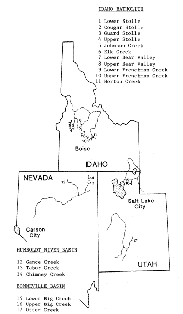
Figure l.
General location of livestock-fishery study sites.
In the Idaho study areas, waters are low in mineral content because of the predominance of granitic bedrock in the Idaho Batholith. The study areas are in meadows at 1,890 to 1,950 m. (6,200 to 6,400 ft.) elevation, which were formed as an outwash train from extensive Pleistocene glacial deposits. The mountain meadows cover 1.62 million hectares (4 million acres) in the 11 western states (US Department of Agriculture 1972) and support more beef per hectare (acre) than any other range type (Skovlin in press).
The Utah-Nevada study areas are in the Basin-Range province in broad valley-type streams with relatively high mineral content. Riparian areas are much narrower than in the Idaho sites and are usually only thin ribbons along the borders of the streams. The Nevada studies evaluate grazing effects on the Humboldt cutthroat trout, a threatened and endangered species, as well as on rainbow trout and sculpin. The Utah studies evaluate grazing effects on rainbow trout and brown trout (Salmotrutta [Lineaus]).
The first stage of these studies will compare commonly used grazing strategies at different levels of herbage use in different riparian/fishery types. The second stage will develop and test those grazing strategies believed to be more compatible with riparian systems. The overall study objectives are:
1) to improve riparian/stream methodology so it will more accurately determine stream conditions and changes in these conditions;
2) to determine the potential of rehabilitating riparian/fishery environments altered by overgrazing;
3) to determine the difference in riparian/stream influences from grazing by different classes of livestock (sheep and cattle);
4) to determine the influences that different types of grazing strategies have on riparian/fishery environments; and
5) to determine the optimum mix of riparian forage utilization and fish needs.
Study sites have been established in grazed and nongrazed ranges. Historically grazed areas are being rested from grazing to determine rehabilitative processes and potentials. Previously nongrazed ranges are now being grazed to determine the effects and the processes that cause these effects on riparian/stream systems. All study sites may not yield immediate answers because environmental changes caused by livestock grazing may accumulate slowly over a long time.
Livestock/fishery research is difficult because in the early stage of degradation streams are often resilient and adaptable to change. Streams have a variety of ways of compensating for applied stress, a capacity which allows for assimilating and/or masking of small, short-term effects. These effects can accumulate until they reach the incipient lethal level for the fish population; then sudden collapse of the population can occur. Livestock grazing can each year cause microchanges in the environment, changes which can accumulate over many decades and thus be difficult to detect in short-term studies. Whether a stream suffers a catastrophic degrading event from a flood or the degradation of small events accumulating over a long period, the result for fish can be the same. In either case the stream and its fisheries have been altered, and, even once stress is relieved, recovery may take many years.
Preliminary Findings
Sheep Grazing
Different classes of livestock graze watershed in different ways. Sheep usually use slopes and upland areas, while cattle tend to use the lesser slopes or bottomlands that might have riparian zones. Because sheep grazing on public lands is usually controlled by herding, it is possible for sheep to graze a watershed without exerting direct significant influence on the riparian system. However, if sheep are not controlled properly impacts to riparian areas would be expected. Two types of sheep grazing systems are being studied: continuous grazing and rest-rotation.
Continuous Grazing
Statistically significant differences exist between reaches of the same stream on the Horton Creek site (fig. 1, site 11). One stream reach flowed through a heavily grazed meadow, but an adjacent downstream reach in the same meadow received light or no grazing each year (table 1). Although grazing intensity was insignificant in the fenced portion of the meadow, there was some trespass grazing in years when fences were not maintained properly. When the meadow was heavily grazed by sheep in large numbers, the stream reach became four times wider and only one-fifth as deep as the reach in the adjacent, lightly grazed meadow (fig. 2). In the heavily grazed meadow, streambanks were sloped sharply out, undercut banks were almost eliminated, the quality of riparian system decreased, and bank alteration was 15 times greater. In addition, four times as much stream surface was exposed to solar radiation, and streamside water depth was only one-thirteenth as deep as in the reach in the lightly grazed area. Fish density and biomass (annual average from 1978 through 1980) per unit area were 7.6 and 10.9 times greater, respectively, in the lightly grazed stream reach than in the heavily grazed stream reach (table 1). In the reach in the lightly grazed pastures, trout numbers per linear foot of stream were about 1.7 times greater than in the reach in the heavily grazed pasture. Fish density was much higher in the reach in the lightly grazed pasture, due in part to the narrower stream width there.
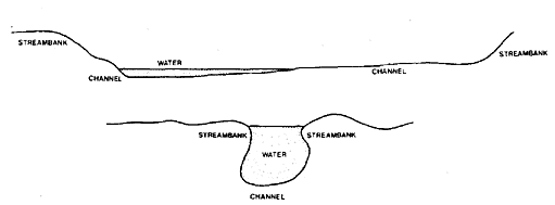
Figure 2.
A typical stream channel profile
in the heavily grazed site (above)
and the lightly grazed site (below).
Rest-Rotation
No significant changes in trends were found in environmental factors in that portion of Frenchman Creek that flowed through a series of meadows grazed by sheep using a herded rest-rotation system. On all of the sites grazed by sheep, the water column, stream channel, streambank, and riparian vegetation are exhibiting no detectable alterations from grazing. The stream is healthy; no significant artificial changes in the existing high fish populations could be detected. The herder has been able to graze the sheep lightly in the streamside zones, with
| ||||||||||||||||||||||||||||||||||||||||||||||||||||||||||||||||||||||||||||||||
riparian herbage utilization less than 5%. Sheep bedding has been offsite.
A rest-rotation grazing system that includes proper herding of sheep to control animal distribution and forage utilization apparently results in insignificant onsite impacts to this type of riparian/stream environment. This is a significant finding, and it sheds new light on statements by Skovlin (in press), Platts (1975, 1979), and McGowan (1976) that no known range management strategy has proven effective in adequately protecting riparian environments. The rest-rotation system should work well throughout the Rocky Mountain area where animal distribution is tightly controlled. It is possible, however, that a continuous, light-to-moderate grazing strategy under good herding could also give good results. This technique has not been tested.
Cattle Grazing
Rest-Rotation Strategy
Cattle have been grazing for two years (the early and late grazing phases of the three-stage rest-rotation cycle) on four Idaho sites in formerly ungrazed meadows (fig. 1, sites 1–4). Cattle grazing has also been introduced at two sites previously grazed lightly by sheep (fig. 1, sites 9 and 10). The riparian areas within these sites were grazed at different intensities, ranging from 25–80%.
After two years of cattle grazing, no significant changes could be detected in any water column or stream channel environmental conditions. The changes that were detected were some minor streambank instability and increased vegetation use. To date no detectable changes have occurred in fish population because of grazing influences.
It is too early to determine if these rest-rotation grazing systems with their different degrees of grazing intensity are compatible with the stream and its fisheries. A minimum of two grazing cycles (six years) will be needed before sufficient trend information will be available.
A key conclusion evolving during the early stages of the study is that when riparian systems are first grazed, initial adverse impacts will show on the streambanks and riparian vegetation. If this trend remains consistent, it may be possible to detect and correct livestock impacts occurring on good-conditioned riparian/stream environments before the fishery is affected.
Continuous Grazing (Nevada and Utah)
Statistically significant differences in riparian/stream environmental condition measurements were observed over two years between continuously grazed pastures (60–100% utilization) and adjacent rested pastures (fig. 1, sites 12–14). The rest from grazing usually resulted in less streambank erosion and allowed streambanks to rebuild, with a corresponding decrease in stream width. Average stream depth and streamside water depth were usually greater in the rested areas. Vegetative overhang was usually much greater and streambank stability better in the rested areas. The studies have shown that continuous grazing with commonly used grazing intensities causes riparian/stream environment deterioration. In none of the study sites did improvements occur when a continuous grazing system was used.
Future Range Research Needs
To date most rangeland research has been devoted to forage conditions, animal growth, and sediment movement off rangelands. Skovlin (in
press) found abundant information on the effects of grazing systems and intensities on plant communities, livestock production, and watershed response (not including streams), but very little on riparian response. Clearly, there is insufficient information to assist land managers in determining if conventional grazing systems are causing stress to riparian/stream systems. It becomes imperative then that research determine those grazing strategies compatible with each of the riparian/stream habitat types, and find ways to modify those strategies that are not. To do this the following questions need better answers.
1. What grazing timing and intensity is most compatible with the ecological needs of riparian systems?
2. Can depleted riparian vegetative communities be restored using present grazing systems?
3. How do different classes of livestock affect the riparian environment?
4. What are the responses of fish and wildlife to different levels of riparian forage use?
5. How much riparian vegetation canopy is needed for optimum stream temperatures and overhead cover for fish?
6. What amount and type of riparian vegetation is needed to maintain streambank stability?
7. What environmental indicators first signal changes in the quality of riparian environment?
8. What techniques are available to rehabilitate degraded riparian systems?
To answer these questions research should be directed toward three targets.
Target I—Develop, test, and standardize methods to document the status and changing trend of riparian/stream systems.
Target II—Use these refined methods to evaluate all commonly used grazing management strategies to determine their potential for maintaining healthy riparian/stream systems.
Target III—Using the positive features found in these systems, design new grazing management strategies that are more compatible with riparian/stream systems.
After seven years of testing our methodology, we are not completely satisfied with the accuracy and precision of our environmental measurements. Consequently, we are having difficulty evaluating the commonly used grazing strategies. Researchers need to complete Target I before Targets II and III can be completed, but Target I is mostly ignored while researchers try to jump directly into II and III. Researchers must be able to measure small environmental changes and to differentiate between natural and artificially caused changes before valid results can be obtained.
Our methods, although crude in some aspects, have allowed us to do some evaluating of commonly used grazing strategies. This evaluation shows that successful management of riparian/stream systems requires the range manager to use or develop grazing strategies where timing, utilization, and especially animal distribution can be controlled within the entire allotment.
Literature Cited
Armour, C.L. 1977. Effects of deteriorated range streams on trout. 7 p. USDI Bureau of Land Management, Idaho State Office, Boise, Idaho.
Behnke, R.J. (in press). Livestock grazing impacts on stream fisheries: problems and suggested solutions. In : John Menke (ed.). A symposium on livestock interactions with wildlife, fisheries and their environments. [Sparks, Nevada, May 1977]. USDA Forest Service Pacific Southwest Forest and Range Experiment Station, Berkeley, Calif.
Behnke, R.J., and M. Zarn. 1976. Biology and management of threatened and endangered western trouts. USDA Forest Service GTR-RM28. 45 p. Rocky Mountain Forest and Range Experiment Station, Fort Collins, Colo.
Gifford, G., and R. Hawkins. 1976. Grazing systems and watershed management: a look at the record. Journal of Soil and Water Conservation 31(6):281–283.
Holscher, C., and E. Woolfolk. 1953. Forage utilization by cattle in the Northern Great Plains Range. US Department of Agriculture Circular No. 918. 27 p.
Leopold, A.S. 1974. Ecosystem deterioration under multiple use. p. 96–98. In : Proceedings of the wild trout management symposium. 103 p. USDI Fish and Wildlife Service, and Trout Unlimited, Denver, Colo.
McGowan, Terry. 1976. Statement on improving fish and wildlife benefits in range management. p. 97–102. In : Proceedings of a seminar on improving fish and wildlife benefits in range management [Washington, D.C., March 1976]. 118 p. USDI Fish and Wildlife Service, Biological Services Program, Washington, D.C.
Marcuson, Patrick E. 1977. The effect of cattle grazing on brown trout in Rock Creek, Montana. Project No. F-20-R-21-11-a. 26 p. Montana Department of Fish and Game, Helena.
Meehan, William R., and William S. Platts. 1978. Livestock grazing and the aquatic environment. Journal of Soil and Water Conservation 33(b):274–278.
Platts, W.S. 1974. Geomorphic and aquatic conditions influencing salmonids and stream classification with application to ecosystem classification. 200 p. USDA Forest Service, Surface Environment and Mining Project, Billings, Mont.
Platts, W.S. 1975. Livestock interactions with fish and aquatic environments: problems in evaluation. p. 498–504. In : Transactions of the Forty-third North American Wildlife and Natural Resources Conference. Wildlife Management Institute, Washington, D.C. 510 p.
Platts, W.S. 1976. Validity in the use of aquatic methodologies to document stream environments for evaluating fishery conditions. Instream Flow Needs Proceedings 2:267–284. American Fish Society, Bethesda, Md.
Platts, W.S. 1979. Livestock grazing and riparian/stream ecosystems: an overview. p. 39–45. In : O.B. Cope (ed.). Proceedings of the forum on grazing and riparian/stream ecosystems. [Denver, Colo., Nov. 3–4, 1978]. 94 p. Trout Unlimited, Inc. Vienna, Va.
Platts, W.S. 1981. Overview of the riparian/fish habitat issue in the western United States. p. 195–201. In : Proceedings of sixtieth annual conference of the Western Association of the State Game and Fish Commissioners. [Kalispell, Mont.]. 649 p.
Ray, G.A., and W.F. Megahan. 1978. Measuring cross sections using a sag tape: a generalized procedure. USDA Forest Service GTRINT-47. 12 p. Intermountain Forest and Range Experiment Station, Ogden, Utah.
Skovlin, J. (In press.) The impacts of grazing on wetlands and riparian habitats. In : Impacts of grazing intenstiy and specialized grazing systems workshop. [El Paso, Texas, March 1981]. National Science Foundation, Washington, D.C.
Skovlin, J.M., and W.R. Meehan. 1975. Draft study plan—the influence of grazing on restoration of riparian and aquatic habitats in the Central Blue Mountains. USDA Forest Service, Pacific Northwest Experiment Station, LaGrande, Oregon.
Thomas, Jack Ward, Chris Maser, and John E. Rodiek. 1977. Riparian zones—their importance to wildlife and their management. 14 p. USDA Forest Service, Pacific Northwest Forest and Range Experiment Station, Corvallis, Oregon.
US Department of Agriculture. 1972. Western regional working conference—results of work group sessions—delegate ratings. National Program of Research for Forest and Associated Rangelands. 39 p. USDA Forest Service, Intermountain Forest and Range Experiment Station, Ogden, Utah.
Van Velson, R. 1979. Effects of livestock grazing upon rainbow trout in Otter Creek, Nebraska. p. 53–55. In : O.B. Cope (ed.). Proceedings of the forum on grazing and riparian/stream ecosystems. [Denver, Colo., Nov. 3–4, 1978]. 94 p. Trout Unlimited, Inc. Vienna, Va.
Senate Bill 397
A New Approach to Riparian Area Protection in Oregon[1]
Nancy E. Duhnkrack[2]
Abstract.—Legislation enacted by the State of Oregon in August, 1981, established an innovative program for protection or rehabilitation of privately owned riparian lands through use of tax incentives for property owners. This voluntary incentive program has support from a diverse base of interests in Oregon and could be an effective alternative or companion to programs based on regulations or acquisition in other states.
Introduction
The Legislative Assembly declares that it is in the best interest of the State to maintain, preserve, conserve and rehabilitate riparian lands to assure the protection of the soil, water, fish and wildlife resources of the State for the economic and social well-being of the State and its citizens.
So begins the preamble to Senate Bill 397, legislation enacted by the State of Oregon during the 1981 legislative session to encourage the protection or rehabilitation of privately owned riparian zones. With passage of SB 397, Oregon took a major and much-needed step forward in riparian area protection, setting in place a cornerstone upon which to build a comprehensive riparian system protection program. Passage of SB 397 was due, in large part, to the design of the bill and its consequent appeal to a broad variety of interests. This paper will outline the impetus for and content of SB 397. The paper will also discuss the issues surrounding and components of the legislative campaign which resulted in its passage. But first I will give a brief overview of efforts in Oregon to protect riparian areas prior to passage of SB 397.
Past Riparian Area Protection in Oregon
The Private Sector
There is no coordinated effort in Oregon to inventory, study, or protect privately owned riparian areas. A multitude of programs under many jurisdictions have, to a greater or lesser extent, recognized riparian areas and acted to protect them. I will discuss two of the programs unique to Oregon and some of their more notable aspects.
Since 1973, the State of Oregon has had a land-use planning program (codified as Oregon Revised Statute [ORS] 197) which requires local jurisdictions (cities and counties) to develop comprehensive plans for land use in compliance with 19 statewide planning goals. In the process of developing these plans, the jurisdictions must complete an inventory of resources within their boundaries, establish land-use policies based on these inventories and in compliance with the goals, and develop ordinances to implement such policies. One of the statewide goals, Goal 5, specifically mentions the protection of scenic and natural areas and fish and wildlife habitat. To comply with Goal 5, local jurisdictions have inventoried riparian areas and adopted a variety of ordinances to protect them. These ordinances include building setbacks, overlay zoning, "greenway" zoning, density transfers, and permit systems. The strength of these ordinances varies greatly from jurisdiction to jurisdiction. At a minimum, Goal 5 and the statewide land-use planning process have fostered an awareness among local officials and planners of riparian areas and their significance.
In 1970, Oregon established a Scenic Waterways program (ORS 390.805–390.925) very similar in purpose to the National Wild and Scenic Rivers System. Through the state program eight river segments, totalling 510 river miles, are protected from adverse development. Private land use along these rivers is regulated through a permit system. Both Oregon's Scenic Waterways and land-use planning programs have had far more success in controlling construction and development (e.g., houses, marinas, industrial parks) in
[1] Paper presented at the California Riparian Systems Conference. [University of California, Davis, September 17–19, 1981].
[2] Nancy E. Duhnkrack is Water Resources Coordinator for the Oregon Wilderness Coalition, Eugene, Oregon.
riparian areas than in regulating forest or agricultural practices.
Oregon has many additional programs, similar to those of other western states, which address management of riparian lands. The State Forest Practices Act (ORS 527.610–527.730), Agricultural Framework Plan, and efforts funded under Section 208 of the Clean Water Act are examples. Of these, the Forest Practices Act has done the most to promote wise management of riparian areas, particularly in western Oregon. However, the narrow focus of each of these programs has limited their effectiveness in riparian area protection. The Forest Practices Act, for example, only governs commercial forest operations. It does not regulate grazing in riparian areas on forestlands.
The Public Sector
The 52% of Oregon which is publicly owned consists primarily of lands managed by the USDA Forest Service (FS) and the USDI Bureau of Land Management (BLM). Here, in contrast to private lands, specific management direction for inventory, study, protection, and enhancement of riparian lands has been developed. In 1979 the Riparian Habitat Subcommittee of the Oregon/Washington Interagency Wildlife Committee (composed of representatives of the FS, BLM, USDA Soil Conservation Service [SCS], USDI Fish and Wildlife Service [FWS], Oregon Department of Fish and Wildlife [ODFW], and Washington Department of Game [WDG]) prepared "Managing Riparian Ecosystems (Zones) For Fish and Wildlife in Eastern Oregon and Eastern Washington" (Oregon/Washington Interagency Wildlife Committee, Riparian Habitat Subcommittee 1979). This report outlines, in very basic terms, broad procedures for evaluating the present condition of riparian ecosystems, projecting potentials for enhancement, and establishing recommended habitat conditions for managing fish and wildlife within riparian ecosystems.
Other research available to public land managers in Oregon includes work coordinated by Dr. Jack Thomas of the Pacific Northwest Forest and Range Experiment Station, La Grande, Oregon, and published by the FS on wildlife habitats in managed forests and rangelands. Research has been completed for the Blue Mountains of eastern Washington and Oregon (Thomas 1979) and for the Great Basin of southeastern Oregon (Thomas etal . 1980). Preparation of similar reports for other geographic areas wthin the region is well underway. These reports provide valuable definitions of riparian areas, specify wildlife habitat needs met by riparian zones, and suggest specific management prescriptions for these zones.
Work done cooperatively by the USDC National Marine Fisheries Service, the FWS, and the ODFW on fish habitat restoration in eastern Oregon has added another dimension to research on riparian areas in Oregon. This work, begun in 1978 under a USDI Bureau of Reclamation (BR) authorization and nearing completion, has quantified the magnitude of streamflow augmentation possible when riparian areas are restored.
Region 6 of the FS (Washington and Oregon) has adopted the evaluation procedure for assessing the condition of riparian areas contained in the Interagency Wildlife Committee Report, (Oregon/Washington Interagency Wildlife Committee, Riparian Habitat Subcommittee 1979), a supplement to the Forest Service Manual. Following inventory and evaluation of riparian areas, each National Forest has been directed by the Regional Office to recommend habitat objectives for these areas and develop management prescriptions to meet these objectives. The FS mandates that development of these prescriptions include an analysis of the trade-offs involved and the cost-effectiveness of each management prescription, a time frame for implementation, and a monitoring procedure. This process will be part of the new land management planning process mandated by the National Forest Management Act (1976). Since no National Forest within the region has completed a draft Forest Plan under the new process it is difficult to assess the degree to which these guidelines will be implemented.
Rather than adopt the Interagency Wildlife Committee Report as agency policy, the Oregon State Office of BLM issued, in 1980, supplemental policy and procedures to BLM Manual 6740—Wetland-Riparian Area Protection and Management.[3] This supplement provides very specific direction to BLM district managers for the inventory and management of riparian areas. For example, the policy states, with regard to degraded riparian systems: "areas that are not currently classified as riparian habitats but have the potential for producing significant amounts of riparian vegetation should be considered for restoration; e.g., former wet meadows or marshes."
A preliminary judgement, at least, can be made of BLM's implementation of this supplemental policy as grazing management plans have been completed for several BLM districts in Oregon. In general, definitions of riparian areas are narrow, inventory is less than adequate (in one instance riparian areas were restricted to those adjacent to perennial streams and springs), evaluation procedures are not uniform, and management direction provides for protection or enhancement of a very small percentage of the total riparian area within the district (see Lakeview, Ironside, or Drewsey District Grazing Environmental Impact Statement[4] .
[3] Memorandum No. 8243, February 22, 1980. From the Oregon State Director, USDI Bureau of Land Management, to District Managers, Portland, Oregon.
[4] Lakeside grazing environmental impact statement, Portland, Ore., 1981. Ironside grazing environmental impact statement, Portland, Ore., 1980. Drewsey grazing environmental impact statement, Portland, Ore., 1979.
Full implementation of both the BLM and FS riparian area management policies has been and will continue to be hampered by a number of factors, including the following.
1. Lack of an adequate inventory—neither BLM nor FS has a complete inventory on the lands they manage. The time constraints imposed by each agency's land-management planning process have forced both to make management decisions without full area inventories or inventories of resources in the riparian areas. This problem has been compounded by the absence of a common definition of riparian areas.
2. Lack of funding—neither BLM nor FS has funds adequate to restore or protect riparian areas. This has forced the agencies to pick and choose specific riparian areas for protection rather than to implement broad policies for the management and enhancement of all areas.
3. Pressure from other uses—as in other states, riparian areas in Oregon are subject to use pressures from livestock grazing, timber cutting, road construction, rock and gravel quarries, and recreational development. The most significant of these use pressures is from livestock grazing. Evidence of this is seen in the management of Malheur National Wildlife Refuge in southeastern Oregon. Established in 1908, primarily because of its value to migratory waterfowl, the area has been the focus of unabated controversy over cattle grazing. In 1948, 50,000 Mallards were counted in the refuge; in the early 1970s the number was 2,000. Again, in the early 1970s for two consecutive years, 230 nesting pairs of Sandhill Crane produced only two young. Destruction of habitat and increased predation stemming from overgrazing by cattle have been cited as the principal cause of the Mallard population decline and lack of Sandhill Crane nesting success. Since the early 1970s, cattle allotments have been reduced. The Mallard population now numbers close to 14,000, and the cranes succeeded in hatching 46 young in 1980. Nevertheless, this is an example of the kind of pressures land managers face in Oregon when determining the highest and best use of public riparian areas.
An unfortunate attitude was encountered among public land managers and land-use planners in interviews. Many of these professionals regarded the issue of riparian area management as unduly polarized and subject to ready compromise. Their attitude was generally expressed: "The environmentalists want to lock up these areas, the Cattlemen's Association wants to ravage them—we'll come down somewhere in the middle with 'multiple use' for some and 'single use' for others." This attitude, while making the planner's job easier ("I know I'm doing the right thing when nobody is happy with the decision") ignores the wide range of possibilities for creative management and education to meet many or all resource demands within the planning unit (e.g., seasonal grazing after full recovery in certain riparian zones). Most public land managers in Oregon recognize the multiple benefits of healthy riparian zones, and most know what management techniques will protect or enhance riparian areas. Broad-based implementation of these techniques is the missing element.
Pilot Projects
The several experimental efforts to rehabilitate riparian areas on eastern Oregon rangelands (both public and private lands) are noteworthy examples of riparian area enhancement in Oregon. There, cooperative efforts have been conducted among state and federal agencies, private landowners, and other concerned organizations such as the Northwest Steelheaders. In these 10 or more pilot projects the level of stream corridor recovery has been phenomenal. The vegetative extremes between grazed and ungrazed stream reaches provide a vivid contrast. Adjacent landowners have removed livestock from the stream corridor after noting the revegtation of streambanks in the livestock exclosure and the corresponding increase in streambank stability.
The success of these experimental efforts provided much of the impetus for Senate Bill 397. The question arose: if these efforts have been so dramatically successful, why is there not more rehabilitation of riparian areas? The resistance of landowners to regulatory restrictions of commodity production on their lands without some form of compensation, the cost to landowners, the small return on their investment, the lack of incentives, and the perception of landowners that "things had always been that way" were all cited as factors. SB 397 was specifically designed to counterbalance these factors and provide constructive solutions to the problems of cost and lack of incentives. The bill emphasized enhancement, avoided the spectre of "bureaucratic regulation" by being voluntary, provided tax incentives directly to the person performing the work, and focused on the local nature, significance and solution to the problem. The remainder of this paper is devoted to the content of SB 397 and its legislative enactment.
Senate Bill 397
Establishment of new government programs, particularly new programs based on tax incentives, is no easy task in years of revenue shortage. The mood in the Oregon Statehouse during the 1981 legislative session was far from festive as conservatives and liberals alike were forced to slash agency budgets and scrape for every penny. Yet, on August 1 the Legislative Assembly established a new program for riparian area protection, a program based on a property tax exemption and income tax credit.
What gave SB 397 the edge this session when everything from weatherization tax credits to farm deferrals came under attack? A broad base of support, a strong grass-roots network, the voluntary nature of the program, and a slide
show that convinced even the most skeptical were a few of the elements that made SB 397 a winner.
The Legislation
SB 397 contains two mechanisms to encourage the maintenance or rehabilitation of privately owned riparian areas:
1. it provides an advalorem property tax exemption for riparian lands that are protected or enhanced; and
2. it grants a 25% personal or corporate income tax credit for costs incurred in fish habitat improvement projects (anything, for example, from spawning gravel enhancement or pool construction to streamside fencing).
Both programs are voluntary. The legislation makes no provision for public access to exempted properties, nor does it exclude all uses from the riparian area.
The programs are administered by the ODFW, the state agency responsible for fish and wildlife management. ODFW responsibilites, as spelled out in SB 397, and the responsiblities of the landowner and the local taxing authority, in this case the county assessor, are outlined below.
As defined in the legislation, designated riparian land includes "the beds of streams, the adjacent vegetative communities and the land thereunder, which are predominantly influenced by their association with water." Over the next year ODFW is required to develop standards and criteria for the designation of riparian areas. It must also develop a list of approved restoration practices which, when implemented, would result in the recovery of degraded riparian areas.
A landowner desiring a property tax exemption under the SB 397 program must first make an application to the county assessor. The application must describe the land for which the exemption is requested and the current use of the land. Once the county assessor notifies ODFW of an application, the ODFW field staff will make an on-site survey of the property and negotiate a signed management agreement with the landowner. The management agreement specifies allowed uses of the riparian area as well as the boundaries and size of the exempted property. No property may be exempted under the SB 397 program unless the activities specified in the management agreement are in compliance with ODFW standards and guidelines.
The ODFW must notify the county assessor and the applicant of its approval or disapproval of an application. If approved, the county assessor notes on the assessment roll that the land is exempt from taxation.
In addition to outlining this procedure, SB 397 sets up a penalty for withdrawal from the program in the form of a required payment of up to five times the amount of taxes due on the exempted property during the most recent tax year (the amount to be determined by the number of years the land was held in the program). The act authorizes assessors to request and receive land-use reports from owners of exempted lands. An assessor may also request ODFW to determine whether lands continue to qualify for the tax exemption, if there is reason to believe the management agreement has been violated.
Administration of the income tax credit portion of SB 397 follows a similar procedure. Over the next year, ODFW must develop rules and procedures for the tax credit program, specifying the criteria to be used to evaluate fish habitat improvement projects and the standards for project approval. The ODFW is required to make both a pre-project and a project-completion certification for each project.
Any resident individual is allowed a 25% income tax credit for funds expended on fish habitat improvement projects provided:
1. he/she is the person who actually expended the funds for construction or installation of the project, and
2. the project was not required by existing state or federal statute.
To receive the tax credit, an individual must apply for and receive a pre-project and project-completion certification. The pre-project application must include a description of the proposed project and its expected benefits, a drawing of the project and an estimate of project costs. After project completion, ODFW inspects the project and issues a final certification of the project costs, which can be no more than 10% in excess of the amount approved in the preliminary certification.
Enactment of SB 397
Passage of the two tax incentive programs reflected in SB 397 was a complex process which involved much compromise and negotiation. The issues raised by legislators were many; the bill went through three sets of comprehensive amendments before its final passage. The bill was heard by three committees—the Agriculture and Natural Resources and Revenue committees in the Senate, and the House Revenue Committee. Different versions of the bill were passed by the House and Senate and, ultimately, the bill had to go to a conference committee where a compromise, different than either of the two passed versions, was negotiated. This version passed both the House and Senate on the last day of the legislative session.
Revenue Impact
Chief among the concerns expressed by legislators was the impact of SB 397 on state revenues. Even those legislators most supportive of measures to protect the environment hesitated to support a bill that contained tax-exemption and tax-credit provisions. Two things were done to alleviate legislators' concerns: 1) SB 397 was amended to minimize its impact on revenue; and 2) an accurate assessment of the projected property tax revenue shift was made.
The point was continually made that the tax exemption portion of SB 397 was "a shift, not a gift," that is, those taxes foregone because of granted exemptions would be made up through slightly higher taxes on other lands within each taxing district. To minimize the property tax shift, limits were placed on the amount and types of riparian areas eligible for the property tax exemption. These limits are listed below.
1. Lands eligible must be designated forestor farmlands (including rangelands) outside of adopted urban growth boundaries. This type of limitation was possible because of the comprehensive, statewide land-use planning and zoning process mentioned earlier.
2. Lands exempted can be no more than 33 m. (100 ft.) from the line of non-aquatic vegetation.
3. No more than 160 km. (100 mi.) of streambank can be exempted each year in any one county. Oregon has 36 counties, for a total limit of 5,760 km. (3,600 mi.) of newly exempted streambank each year.
Once these limitations were established, an accurate assessment of the maximum total property tax shift had to be made. Based on geography and land use, eight representative counties were selected. Supporters of the bill visited each county planning and assessor's office to obtain up-to-date land-use and tax lot maps of the county. Ten lots each in the forest and farm land-use zones were selected. Each lot contained or abutted a free-flowing stream.
Data were then compiled on each lot. These included: description, size, tax rate, lot valuation, current tax, and stream footage. These data were used to compute the riparian area valuation together with tax and tax rate, such that an average riparian area tax rate could be computed for each land-use category in each county. An overall average rate was determined and applied to the 28 other counties to give a total maximum tax shift under SB 397.
Based on an estimated 40-ft. average width of exempted properties, the total tax shift in Oregon, if the program is fully implemented, will be $215,000 statewide in 1983 (less than $6,000 per county) and $450,000 in 1984. This low figure went far to alleviate legislators' concerns. The true test of the methodology came when the bill came before a former tax assessor, now a legislator, in the House Revenue Committee. It held up under his scrutiny and won his support for the legislation, even though he hadn't voted for one other bill providing a tax break the entire session!
Resolving legislative concerns regarding the tax credit portion of SB 397 was somewhat easier. A limit was set on the total dollar amount of projects eligible annually for preliminary certification.
In addition to these limitations, tax credits and tax exemptions under SB 397 cannot be granted until 1983. This gives ODFW time to develop program guidelines and procedures, and, more important to legislators, it means no fiscal impact during this budget biennium.
A Small Investment with a Big Return
"Vote Yes on SB 397—A Small Investment With a Big Return" was the slogan when the bill went to the Senate floor for a vote on final passage. Supporting literature read: "Would you believe one mile of dry eroding gulch in Oregon can be transformed into a stable meadowland with yearround streamflow for less than $1,500?" Emphasis was placed on how little SB 397 would cost and the value of the benefits it would provide—from increased salmon and trout production, to bank stabilization, to increased late-season flows. Then the cost of providing these same benefits through alternate means—such as rock revetments, dams for water storage, fish hatcheries, and water treatment plants—was emphasized. The data provided to the committees and individual legislators covered subjects from the number of wildlife species found in a healthy riparian area, to the rate of silt deposition in healthy riparian zones during periods of peak spring runoff, to the value of the sport and commercial fishery in Oregon.
The message was: SB 397 is the most cost-effective means of providing all these benefits with a minimum of both regulation and public expenditure.
The Broad Base of Support
SB 397 was introduced at the request of the Oregon Chapter, American Fisheries Society (AFS). Even if AFS members could have convinced legislators on their own of the dollar-wise nature of SB 397, its passage would not have occurred without a broad base of supporters actively working for passage of the bill. The bill was designed to attract a wide spectrum of support. Its voluntary nature appealed to landowners who have repeatedly called for more incentives and less regulation. The bill also meshed well with existing state and federal efforts in Oregon, such as the ODFW Salmon, Trout Enhancement Program which works with volunteers to increase fish production through, for example, stream habitat improvement or egg-box installation.
For these and other reasons, farmers and ranchers, sport and commercial fishermen, members of the timber industry, hunters and wildlife enthusiasts, state agency representatives, and fish and wildlife biologists wrote or called their legislators in support of SB 397 and came to Oregon's state capitol to testify at hearings on the bill. This kind of support made it possible for a leading liberal Democrat from Portland to sign with a conservative Republican from eastern Oregon as chief sponsors of the legislation. This broad base kept the legislation from being stereotyped as one to which a legislator's response would be an automatic yes or no. Moreover, the bill did not become trading stock in the political marketplace and, instead, had to be judged on its own merits.
The Slide Program
A separate section of this paper is devoted to one very special, pivotal element of SB 397's legislative campaign: the slide program. The program was simple; it utilized two projectors and was narrated in person. It varied in length from five to 20 minutes. It was shown in semilit rooms and rooms where legislators had to crane their necks to see the screen. Committee staff people hated the idea of a slide program—it was a struggle sometimes to set it up. But in every case it was well worth the struggle, for if any one element of the legislative campaign can be singled out as that which won the day, it was the slide show.
Professionals sometimes fail to realize just how foreign the word "riparian" sounds to a lay person. Many legislators, who are insurance salespersons, schoolboard members, or realtors during the off session, have never heard of riparian areas. "Is that something like artesian?" "You mean those bushes along the stream are good for something?" The slide program convinced legislators that riparian areas were indeed important, that their values were not some nebulous silver-lining pulled from the sky by a feverish biologist.
The slide program documented two areas in eastern Oregon where riparian rehabilitation has taken place. It began with a "before" slide, then traced the phenomenal regrowth of vegetation that occurred in the years after fencing to exclude livestock grazing. The program showed the eroded gulch filling in, the shoreline stabilizing, and year-round streamflow being restored. It showed the transformation of a dry, hot ditch to a cool stream shaded by lush, green trees in a period of five years. One slide sequence is shown in figure 1. After viewing the slide show, legislators knew what SB 397's purpose was, and they voted for its passage. The visual element of the legislative campaign was simple, inexpensive, and indispensible.
Conclusion
This paper has touched upon many of the existing methods of inventory and protection of riparian areas in Oregon. It has dealt in depth with SB 397—recently enacted legislation which provides incentives for rehabilitation or maintenance of privately owned riparian land. Results from implementation of SB 397 remain to be seen. Many compromises were made during the course of the bill's enactment. In particular, strict limitations were placed on the bill's application in order to minimize its fiscal impact. However, supporters of the legislation believe that those riparian areas in Oregon most in need of protection are in the farm- and forestlands eligible for the tax exemption program. SB 397 is an innovative approach to riparian area protection, an approach that supporters feel will work in Oregon and could work well in other states. The programs have already sparked a great deal of interest among landowners. Once implementation begins and results are produced, they will spark more.
Literature Cited
Oregon/Washington Interagency Wildlife Committee, Riparian Habitat Subcommittee. 1979. Managing riparian ecosystems (zones) for fish and wildlife in eastern Oregon and eastern Washington. Oregon/Washington Interagency Wildlife Committee, Portland, Ore.
Thomas, J.W. (tech. ed.). 1979. Wildlife habitats in managed forests: The Blue Mountains of Oregon and Washington. USDA Forest Service Agriculture Handbook No. 553, Pacific Nortrhwest Forest and Range Experiment Station, Portland, Ore. 512 p.
Thomas, J.W., C. Maser, and J. Rodiek. 1980. Wildlife habitats in managed rangelands: The Great Basin of southeastern Oregon. USDA Forest Service, Pacific Northwest Forest and Range Experimental Station, Portland, Ore.
Figure l.
This sequence of photos shows the dramatic recovery of a section of Fifteen-mile Creek, Wasco County, Oregon,
following fencing to exclude livestock. Photos were taken from the same location in (from left to right) 1974, 1975,
1976, and 1978. Slide sequences similar to this one were used to convince legislators of the merits of SB 397.