A Riparian Classification System[1]
R. Roy Johnson, Steven W. Carothers, and James M. Simpson[2]
Abstract.—Riparian ecology, as one of the newest scientific disciplines, is developing a conceptual framework which includes new supportive terminology and classification schemes. This branch of ecology has developed largely in the arid western United States as an offshoot of wetlands ecology. This paper discusses important concepts, classifications, and interrelationships between riparian ecology and other disciplines. This new science is especially important to floodplain zoning and management, natural resource management, and recreation management.
Introduction
The word riparian is derived from the Latin ripa meaning "banks." Although a long-established word, it did not come into common usage until the early 1970s. Now the terms "riparian habitat" and "riparian system" are well known to wildlife and recreation managers. In the most restricted sense, the word riparian refers to the banks of a stream or river (Langbein and Iseri 1960; Oxford English Dictionary [Unabridged] 1979), although the Oxford Dictionary gives "riparial" for either a stream or lake. In its vaguest sense riparian refers to "the banks of a body of water" (American Geological Institute 1962) or bank of a river or other body of water (Random House Unabridged Dictionary 1967), and in its broadest sense riparian refers to "land bordering a stream, lake, or tidewater" (Hanson 1962).
It is not surprising, then, that some investigators would restrict riparian to streams or, at most, freshwater streams and lakes. However, it is often impossible to determine where a montane lake ends and the stream flowing from it begins. Similarly, at the junction of the stream's mouth with a gulf or seacoast, the point where the stream ends and the ocean begins depends on flow levels of the stream and tidal phases of the ocean. Thus, although some boundaries of particular watercourses or lakes are easily definable, their associated ecosystems are often continuous. This, in our opinion, justifies considering habitats associated with lakes, watercourses (temporary or permanent), and tidewater areas as part of a continuous wetland environment, although different segments may have their specifically recognizable riparian communities.
Little more than a decade ago, many resource managers and even scientists concerned with riparian areas were not familiar with the term riparian. Today, though technically an adjective, the word has been "elevated" to a noun (Johnson 1978a) in common usage allowing us to present a "Classification of Riparian."
In 1979 the USDI Fish and Wildlife Service (FWS) published a new system entitled "Classification of Wetlands and Deepwater Habitats of the United States" (Cowardin etal . 1979). This new improved system has synthesized most of the information from earlier, often antiquated, schemes designed for wetlands classification, inventory, and mapping. The foreword for that publication, written by the then-director of the FWS, calls on other federal and state agencies to adopt the system. In addition it states: "Congressional committees will be notified of this adoption action and will be encouraged to facilitate general adoption of the new system by amending any laws that reference the Circular 39 system [i.e., the previous FWS system]" (ibid .). Furthermore, classes to train personnel in the use of the system are now being conducted throughout the United States, not only for FWS personnel, but for those of other agencies as well.
[1] Paper presented at the California Riparian Systems Conference. [University of California, Davis, September 17–19, 1981].
[2] R. Roy Johnson is Unit Leader, Cooperative National Park Resources Study Unit, USDI National Park Service, University of Arizona, Tucson. Steven W. Carothers is Research Scientist, National Park Service, University of Arizona, and an ecological consultant, Flagstaff, Arizona. James M. Simpson is Associate, Museum of Northern Arizona, Phoenix, Arizona.
The implications of these actions are farreaching. This is especially true when one considers that some of the most unappreciated, abused wetland areas of the United States are not considered wetlands under this new classification scheme. Among these excluded systems are some of the riparian wetlands in the more arid western half of the United States, where water is a premium resource. The rapid decline of these western riparian wetlands has been documented in detail, and the causes for the demise of these critical wildlife and recreational areas are at least partially known (Carothers 1977; Johnson and Jones 1977; Johnson and McCormick 1978; Johnson and Carothers 1982).
The system we outline in this paper represents an attempt to develop a riparian classification scheme that is compatible with the current FWS system.
Riparian Ecosystems
Definition of Terms
Wetlands Versus Drylands (Uplands)
The recently recognized field of riparian ecology is employing new terms, defining new conceptual phrases, and developing classification schemes. To demonstrate fully the inclusive scope of what may be identified as "riparian" and the complex and unique plant/animal interactions that contribute to the diversity of life forms within riparian ecosystems, a number of terms and concepts must, at the outset, be reviewed. The relationships among certain of these terms are indicated in table 1.
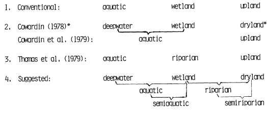
Terrestrial systems have traditionally been differentiated into two basic and mutually exclusive categories, "upland" and "wetland." These are terms not to be confused with "highland" and "lowland," which simply denote elevational differences; uplands and wetlands may be differentiated on the basis of soil moisture. "Uplands" has been used in wildlife literature in opposition to "wetland," but uplands are also commonly thought of as "high ground," denoting an elevational context. To circumvent this problem, Cowardin (1978) used the term "dryland" in contrast to "wetland." We concur with Cowardin's choice in coining a much-needed technical term. The Oxford Unabridged English Dictionary (1979) defines dry land (two words!) as "land not submerged or under water; land as opposed to sea." Upland may be simply defined as "ground above the floodplain" (ibid .), whereas the term "wetland", referring to "land having wet or spongy soil," (Random House Unabridged Dictionary 1967) is not contained in the Oxford Dictionary.
By beginning with a classification system which categorizes systems as either uplands or wetlands, we would agree with other western authorities in considering virtually all riparian areas as wetlands (Brown etal . 1979, 1980). An outstanding discussion of wetlands in the arid Southwest appears in an extensive regional vegetation classification (Minckley and Brown 1982). This treatise characterizes wetlands as follows:
Wetlands are periodically, seasonally, or continuously submerged landscapes populated by species and/or life forms differing from immediately adjacent biotas. They are maintained by, and depend upon circumstances more mesic than those provided by local precipitation. Such conditions occur in or adjacent to drainageways and their floodplains (riparian zones) on poorly drained lands, along seacoasts,
|
and in and near other hydric and aquatic situations, i.e., springs and their outflows, ponds, margins of lakes, etc. The various wetland and riparian communities may be represented as forest, woodland or scrubland, marshland or strand, or be composed largely or entirely of submergent vegetation. [emphasis added]
One of the most perceptive, early characterizations of riparian communities was by Lowe (1964):
A riparian association of any kind is one which occurs in or adjacent to drainageways and/or their floodplains and which is further characterized by species and/or life-forms different from that of the immediately surrounding non-riparian climax. The southwestern riparian woodland formation is characterized by a complex of trees, and their plant and animal associates, restricted to the major drainageways that transgress the landscape of desert upward into forest. It is incorrect to regard this biotic formation as merely a temporary unstable, seral community. It is an evolutionary entity with an enduring stability equivalent to that of the landscape drainageways which form its physical habitat. That is, it is a distinctive climax biotic community . Moreover it is, as are all ecologic formations and their subdivisions, locally subject to, and often dissolved by, the vicissitudes of human occupation. In Arizona, the riparian woodlands have been rapidly dwindling just as the water table has been rapidly lowering. And its trees are now the native phreatophytes of the waterusers. [emphasis added]
In their outstanding book on wildlife habitats, Thomas etal . (1979) did not use the term "wetland" for their work in Oregon and Washington. Instead, they used the term "riparian zone," which they defined as:
. . . an area identified by the presence of vegetation that requires free or unbound water or conditions more moist than normally found in the area.
In addition, we would add the barren, rocky, gravelly, or sandy banks along a body of water.
At the other extreme to the southwestern arid hydrological regime (e.g., the humid northwestern United States), the Oregon Coastal Conservation and Development Commission has a still different definition of wetlands (Metzger 1968 fide Akins and Jefferson 1973):
. . . areas on which standing water, seasonal or permanent, has a depth of six feet or less and where the wet soil retains sufficient moisture to support aquatic or semiaquatic life.
We offer here definitions for various terms, including "riparian wetlands," in full awareness of problems inherent in attempting to categorize and define riparian zones, since biological communities rarely have definitive boundaries. Indeed, the riparian community requires the moisture of the truly aquatic zones from one direction and the substrate of the terrestrial zones from the other. According to Cowardin (1978) ". . . wetland is part of a continuum of land types between deep water and dryland." Thus, as with all classification efforts, a subjective judgment must be made as to where to draw a boundary (where no clear boundary exists) between aquatic, terrestrial wetland, and dryland (upland) zones. The problem of specific definitions becomes even more complicated when certain transitional terms are included. For example, the term "semiaquatic" is used in the extensive treatment of Oregon's coastal wetlands by Akins and Jefferson (1973); however, the term defies definition in their glossary. Semi-aquatic is obviously a term designed to identify vegetation or a zone of vegetation found in the area of transition between aquatic and terrestrial zones.
Semi-Riparian and Pseudoriparian
Another transitional connotation is reflected by the term "semi-riparian zones." The term "semi-riparian communities" was used by Zimmerman (1970) and "semi-riparian habitat" by Hubbard (1971) in their work along the Gila River valleys of southwestern New Mexico, to describe vegetation consisting of "true" riparian species mixed with dryland species. Areas containing such vegetative mixtures are usually found on a gradient extending away from and upslope of the stream or watercourse. The semi-riparian zone, or semi-riparian vegetation, then, is an ecotonal transition between the terrestrial wetland (riparian) zone and the dryland (table 1). As with other ecotones (Johnson 1978b), the semi-riparian zone supports plant and animal species from both the bordering riparian type and the dryland type, as well as species that are almost exclusively specific to these transitional areas. It is important to emphasize here that we are attempting to categorize the various elements of the continuum between wet and dry zones, not merely for the sake of habitat or vegetation classification, but because we can often recognize distinct vegetation and wildlife communities within each of the vegetative types and subtypes.
In general, the semi-riparian community is on a soil substrate intermediate in moisture content between the riparian wetland and the dryland. In the semi-riparian community, where the typically upland species occur on soils containing moisture in excess of their typical habitat, these upland plants frequently attain a popula-
tion density or size-class and vigor greater than that found in the uplands. When a dryland species migrates into the semi-riparian zone and as a result attains a greater density and rate of growth, it may be referred to as a "pseudoriparian" plant (Campbell and Green 1968).
"Pseudoriparian" plants have been described by Campbell and Green as "facultative" in contrast to "riparian" plants, which are "obligate." Unfortunately, the biological definition of facultative as able to live under more than one set of conditions does not indicate a preference for one situation or the other. Therefore, Campbell and Green (1968) have lumped three basic categories of plants under the term pseudoriparian: 1) species which may be best adapted to riparian zones but which will grow in drylands, e.g., velvet mesquite (Prosopisvelutina ); 2) species which are well adapted to either riparian or dryland zones, e.g., desert hackberry (Celtispallida ); and 3) species which are more common in dryland zones but which will grow in riparian zones, often attaining greater size and/or population densities, e.g., Arizona cypress (Cupressusarizonica ). Table 2 demonstrates a classification scheme which further clarifies the concept of "pseudoriparian" in relation to a species' ability to grow in different zones.
| ||||||||||||
The classification scheme we present here is a refinement of an earlier system used by Johnson etal . (1977) composed of three categories: obligate, preferential, and non-riparian. This new, four-category system can be applied to plants or animals. By conducting a strip census or random count of individuals in a region and determining the percentage found in riparian zones compared to nonriparian zones, the species can be assigned to one of the four categories. Reed (in press) has developed a five-category system for wetland plants which would be more definitive, but is too sophisticated for our current level of information.
Perennial, Intermittent, and Ephemeral Riparian Zones
We have recently developed a new, simple, and inclusive classification system for riparian zones (Johnson et al . in press a). By combining standardized terms we have suggested: 1) Perennial Riparian; 2) Intermittent Riparian; and 3) Ephemeral Riparian for categorizing bank systems on streams, lakes, and tidewater areas. These three new riparian types may be applied to zones, vegetation-types, plant or animal communities, or ecosystems. These categories are not substitutes for various terms which have been used for plant species or vegetation communities in the past, including "desert riparian," "stream riparian" (Austin and Bradley 1971), "pseudoriparian," or "semi-riparian." Our three categories refer to zones occurring along and supported by perennial (permanent), intermittent, or ephemeral watercourses, lakes, or tidewaters.
A New Riparian Classification
The aforementioned FWS classification system for wetlands and deep-water habitats (Cowardin etal . 1979) represents the current state of the art in official federal attempts to classify these habitat-types for inventory (in the National Wetlands Inventory), mapping, and protection of the systems. The coauthors of that important publication are eastern investigators and therefore used terms such as "bottomland hardwoods," "wooded swamps," and other regional terms, but riparian was never used. This, in effect, excluded many of the riparian wetlands in the vast region from the Great Plains westward (more than half the United States), with the possible exception of the lush Pacific Northwest. By the standards of some investigators in the wetter, more humid East, many of these areas are not considered wetlands. However, when compared to the surrounding drylands they are unquestionably wetlands, possessing inordinately high wildlife and recreational values and providing premium "living sites" for humans as well as plants and animals.
There are some obvious visual differences between most eastern and western wetlands, but there are also strikingly far-ranging similarities (Johnson etal . in press b). For example, western riparian wetlands are commonly highly visible, more heavily vegetated areas, contrasting sharply with the surrounding dry uplands. This is due largely to the fact that a high percentage of the woody species occurring in these western wetlands show different growth forms from those of surrounding dryland (upland) communities. By contrast, eastern riparian wetlands, along the bottoms of deciduous woodlands, are often not readily apparent because the vegetation growth forms of both habitats are very similar. Eastern investigators, however, have pointed out that the species composition in these eastern riparian woodlands is different from that of the surrounding upland communities (Shelford 1963).
A plethora of other publications have compared species richness and productivity of riparian with upland zones (Johnson and Jones 1977; Johnson and McCormick 1978). Although comparative differences between riparian wetlands and adjacent uplands may not be as extreme for the East as the West, reference to published papers quickly demonstrates that eastern and western riparian systems share a common factor of greater wildlife and recreational importance than surrounding uplands. In addition to the two aforementioned riparian symposia, other publications demonstrating the importance of eastern as well as western riparian systems include a series of national and regional nongame bird symposia conducted by the USDA Forest Service (FS) and bird censuses published quarterly in "American Birds." Johnson (1978b) has shown a differential dependency of avifaunas on riparian zones that is related to regional and local aridity in the Southwest.
Swift and Barclay (1980) demonstrate comparable riparian destruction for both the East and the West (commonly from 70 to 90%). For example, the Sacramento River drainage has an estimated riparian vegetation loss in excess of 98%, while that for southeastern Missouri is approximately 96%. The East apparently still has larger tracts of riparian vegetation left because there were more there originally.
Herein lies the crux of the matter, for in deleting western riparian wetlands from a national inventory, one of the main objectives of the inventory is not met. That objective is to provide practical and legal protection for these wetlands and their attendant ecosystems. Although other programs, such as floodplain zoning and policies of various agencies (see the position papers in Johnson and McCormick 1978), are providing some protection for riparian wetlands, all possible attempts must be made to properly manage these endangered riparian ecosystems.
The "riparian movement" to conserve riparian wetlands is often considered a western concern. However, we have just demonstrated why there is good reason for the East to be equally, or perhaps even more, concerned. Therefore, we present a classification scheme for riparian wetlands which is compatible with the FWS wetlands classification system (figs. 1 and 2). The palustrine system would be the point at which our riparian subsystems would be interfaced with that system (fig. 1). The complexity of these riparian ecosystems has previously defied assignment of subsystems. Table 3 provides our definitions for "riparian" and the subsystems, "hydroriparian," "mesoriparian," and "xeroriparian."
Previous to the 1970s, concerns were largely with clearing riparian zones to allow for "better utility." "Phreatophyte" was the word commonly used instead of riparian to describe vegetation (Johnson and Carothers 1982) for channelization, flood control, water and power projects, and other "water salvage" operations. Today,
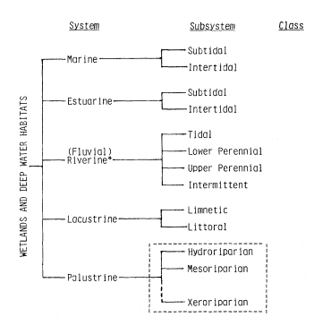
Figure l.
Riparian subsystems superimposed on the National Wetlands
Classification System (modified from Cowardin et al . 1979). * In
more than 25 references checked (standard dictionaries; ecological,
geological, and hydrological dictionaries; and scholarly works on
aquatic ecosystems, the following consensus is established.
Riverine: a) of or pertaining to a river (including the banks); b)
located on or inhabiting the banks of a river. Fluvial: of, pertaining
to, or inhabiting a river or stream. (See Reid and Wood 1976.)
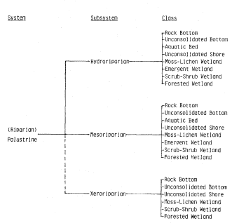
Figure 2.
Riparian subsystems and classes
(modified after Cowardin et al . 1979).
| |||||||||||||||
however, the importance of riparian areas to regional ecosystem maintenance, complexity, and diversity has become evident. While there are still riparian areas to be protected from the insidious destruction that has already reduced this habitat-type to but a small portion of its original coverage, any classification system must consider the entire breadth of the riparian continuum. Our proposed system considers this breadth, extending from dry desert arroyos, and those plants and animals dependent upon their ephemeral water sources, to permanent bodies of water, and perennial marshes and streams.
Conclusion
Riparian systems have been in great demand during the exploratory, settlement, and developmental history of the United States. Riverine and lacustrine riparian zones were extremely useful as routes for exploration and travel; for building of forts, houses, and settlements; for grazing livestock and planting crops; for providing timber and firewood; and, finally, for the development of cities, greenbelts, and recreational facilities. Most reclamation projects and other rural and urban water resource development projects were undertaken prior to the 1960s. It was during the 1960s and 1970s that research documented the tremendous natural and sociological values of the riparian zone. Thus, much of the destruction to riparian ecosystems from these projects had occurred before there was an adequate understanding of the tremendous riparian wildlife and recreational values (Johnson and Carothers 1982). The process of developing the riparian zone for human use destroyed many of the values which had originally attracted humans to these areas. In too many situations, the riparian zone was converted from a lush, verdant "paradise" to a virtual desert (see Johnson and Haight 1983 for definition of desertification).
Insufficient baseline information, inadequate vocabulary, and general overuse and abuse all contributed to the rapid degradation and almost total demise of riparian zones. This was especially true in the arid and semi-arid West where water for human use is at a premium. This paper has mentioned a series of state of the art publications which were instrumental in developing a better understanding of these important riparian areas during the late 1970s. In addition, a vocabulary has developed (McCormick 1978; Warner 1979) and classification schemes have evolved (Lowe 1964; Brown etal . 1979, 1980; Minckley and Brown 1982). These works have demonstrated that riparian systems not only are important to those organisms and communities inhabiting the riparian zone, but also play a vital role in providing food and shelter to many upland and aquatic organisms. Now that the unique role played by riparian ecosystems has been recognized, steps are being taken to preserve and properly manage their fragmentary remains (see Johnson and Haight 1983).
Projects designed to provide water for agricultural, municipal, and industrial uses can now be developed without destroying the recreational and wildlife values of important riparian areas (Carothers and Johnson 1975). Through the use of recently gathered scientific information and application of sound principles of land-use planning, resource management agencies can even reestablish some of the riparian areas which have been destroyed through ignorance during past development projects. No other resource management task is so important to western ecosystems and to the living organisms they include, especially man.
Literature Cited
Akins, G.J., and C.Q. Jefferson. 1973. Coastal wetlands of Oregon. 159 p. Oregon Coastal Conservation and Development Commission, Florence, Oregon.
American Geological Institute. 1962. Dictionary of geological terms. 545 p. Anchor Press, Garden City, N.Y.
Austin, G.T., and W.G. Bradley. 1971. The avifauna of Clark County, Nevada. J. Ariz. Acad. Sci. 6(4):283–303.
Brown, D.E., C.H. Lowe, and C.P. Pase. 1979. A digitized classification system for the biotic communities of North America, with community (Series) and association examples for the Southwest. J. Ariz.-Nev. Acad. Sci. 14(Suppl. 1):1–16.
Brown, D.E., C.H. Lowe, and C.P. Pase. 1980. A digitized systematic classification for ecosystems with an illustrated summary of the natural vegetation of North America. USDA Forest Service GTR-RM-73, Rocky Mountain Forest and Range Experiment Station, Fort Collins, Colo. 93 p.
Campbell, C.J., and W. Green. 1968. Perpetual succession of stream-channel vegetation in a semiarid region. J. Ariz. Acad. Sci. 5:86–98.
Carothers, S.W. 1977. Importance, preservation, and management of riparian habitats: an overview. p. 2–4. In : R.R. Johnson and D.A. Jones (tech. coord.). Importance, preservation, and management of riparian habitat: a symposium. [Tuscon, Arizona, July 9, 1977.] USDA Forest Service GTR-RM-43, Rocky Mountain Forest and Range Experiment Station, Fort Collins, Colo. 217 p.
Carothers, S.W., and R.R. Johnson. 1975. Water management practices and their effects on nongame birds in range habitats. p. 210–222. In : Proceedings of the symposium on management of forest and range habitats for nongame birds. USDA Forest Service GTR-1, Washington, D.C.
Cowardin, L.M. 1978. Wetland classification in the United States. J. Forestry. 1978 (Oct.):666–668.
Cowardin. L.M., V. Carter, F.C. Golet, and E.T. LaRoe. 1979. Classification of wetlands and deepwater habitats of the United States. USDI Fish and Wildlife Service FWS/OBS79/31, Washington, D.C. 103 p.
Hanson, H.C. 1962. Dictionary of ecology. 382 p. Philosophical Library, New York, N.Y.
Hubbard. J.P. 1971. The summer birds of the Gila Valley, New Mexico. Nemouria (Occ. Pap. Del. Mus. Nat. Hist.) 2:1–35. Greenville, Del.
Johnson, R.R. 1978a. Foreword. p. ii. In : R.R. Johnson and J.F. McCormick (tech. coord.). Strategies for protection and management of floodplain wetlands and other riparian ecosystems: Proceedings of the symposium. [Callaway Gardens, Georgia, December 11–13, 1978]. USDA Forest Service GTR-WO-12, Washington, D.C. 410 p.
Johnson, R.R. 1978b. The lower Colorado River: a western system. p. 41–55. In : R.R. Johnson and J.F. McCormick (tech. coord.). Strategies for protection and management of floodplain wetlands and other riparian ecosystems: Proceedings of the symposium. [Callaway Gardens, Georgia, December 11–13, 1978]. USDA Forest Service GTR-WO-12, Washington, D.C. 410 p.
Johnson, R.R., and S.W. Carothers. 1982. Southwestern riparian habitats and recreation: interrelationships and impacts in the Southwest and Rocky Mountain region. Eisenhower Consortium Bull. 12, USDA Forest Service, Rocky Mountain Forest and Range Experiment Station, Fort Collins, Colo. 31 p.
Johnson, R.R., S.W. Carothers, and B.T. Brown. In press a. Perennial intermittent and ephmeral riparian habitats in the Southwest. J. Ariz.-Nev. Acad. Sci., Tempe, Ariz.
Johnson, R.R., S.W. Carothers, and N.H. Goldberg. In press b. Western riparian ecosystems: endangered natural communities. Burgess Publishing Company, Minneapolis, Minn.
Johnson, R.R., and L.T. Haight. 1983. Riparian problems and initiatives in the American Southwest: A regional perspective. In : R.E. Warner and K.M. Hendrix (ed.). California Riparian Systems. [University of California, Davis, September 17–19, 1981.] University of California Press, Berkeley.
Johnson, R.R., L.T. Haight, and J.M. Simpson. 1977. Endangered species vs. endangered habitats: a concept. p. 68–79. In : R.R. Johnson and D.A. Jones (tech. coord.). Importance, preservation, and management of riparian habitat: a symposium. [Tuscon, Arizona, July 9, 1977.] USDA Forest Service GTR-RM-43, Rocky Mountain Forest and Range Experiment Station, Fort Collins, Colo. 217 p.
Johnson, R.R., and D.A. Jones (tech. coord.). 1977. Importance, preservation and management of riparian habitat: a symposium. [Tuscon, Arizona, July 9, 1977.] USDA Forest Service GTR-RM-43, Rocky Mountain Forest and Range Experiment Station, Fort Collins, Colo. 217 p.
Johnson, R.R., and J.F. McCormick (tech. coord.). 1978. Strategies for the protection and management of floodplain wetlands and other riparian ecosystems: Proceedings of the symposium. [Callaway Gardens, Georgia, December 11–13, 1978]. USDA Forest Service GTR-WO-12, Washington, D.C. 410 p.
Langbein, W.B., and K.T. Iseri. 1960. General introduction and hydrologic definitions. USDI Geological Survey Water Sup. Pap. 1541-A. 29 p. US Government Printing Office, Washington, D.C.
Lowe, C.H. (ed.). 1964. The vertebrates of Arizona. 270 p. University of Arizona Press, Tucson.
McCormick, J.F. 1978. A summary of the National Riparian Symposium: A proposal for a national riparian program. p. 362–363. In : R.R. Johnson and J.F. McCormick (tech. coord.). Strategies for the protection and management of floodplain wetlands and other riparian ecosystems: Proceedings of the symposium. [Callaway Gardens, Georgia, December 11–13, 1978]. USDA Forest Service GTR-WO-12, Washington, D.C. 410 p.
Minckley, W.L., and D.E. Brown. 1982. Wetlands. In : D.E. Brown (ed.). Biotic communities of the American Southwest United States and Mexico. Desert Plants 4:223–341.
Oxford English Dictionary (Unabridged). 1979.
Random House Unabridged Dictionary. 1967.
Reed, P.B., Jr. In press. Differentiating between a classification system and a data base. Paper presented at "In-place Resource Inventories; principle and practice: a national workshop. [University of Maine, Arno, August 9–14, 1981]. USDA Forest Service.
Reid, G.K., and R.D. Wood. 1976. Ecology of inland waters and estuaries. 485 p. D. VanNostrand and Company, New York, N.Y.
Shelford, V.E. 1963. The ecology of North America. 610 p. University of Illinois Press, Urbana.
Swift, B.L., and J.J. Barclay. 1980. Status of riparian ecosystems in the United States. 29 p. USDI Fish and Wildlife Service, Kearneysville, W. Va. Unpublished manuscript presented at the 1980 American Water Resources Association National Conference, Minneapolis, Minn.
Thomas, J.W., C. Maser, and J.E. Rodiek. 1979. Riparian zones. p. 40–47. In : J.W. Thomas (tech. ed.). Wildlife habitats in managed forests: the Blue Mountains of Oregon and Washington. USDA Forest Service Agricultural Handbook No. 553, Washington, D.C. 512 p.
Warner, R.E. 1979. California riparian study program. 177 p. California Department of Fish and Game, Planning Branch, Sacramento.
Zimmerman, D.A. 1970. Birds of the Gila River Valley, New Mexico. Unpublished manuscript, Gila National Forest, Silver City. N.M.