Tephra Stratigraphy: Geometry and Depth of Reservoir Rocks
The availability of groundwater and its depth have significant influence on the stratigraphy of hydrovolcanic tephra deposits (Heiken, 1971; Barberi, 1985; Barberi et al ., 1988). In general, where drilling information has located aquifers in volcanic fields, the aquifer depth can be correlated to types of volcanic eruptions. Figure 2.36 shows a hypothetical basin in which the aquifer is shallow or nonexistent at its margins and located at great depth near the basin's center. Eruptions of basic magma through the shallow aquifer form monogenetic structures such as single maars or tuff rings; the aquifer is gradually depleted until eruptions are no longer explosive. The magma then tends to congeal in the conduit, which eventually stops activity. If magma intersects a deep aquifer, it interacts with water under greater pressures; this delays the formation of vapor until the mixture approaches the surface, where it forms frothy ejecta that erupts in a Plinian fashion. The deep mixing does not deplete the aquifer, so repeated eruptions can occur before the magma solidifies. The surface expression of such hydrovolcanism might be a caldera complex with numerous
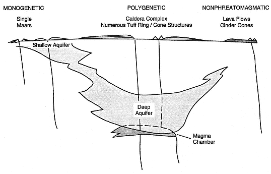
Fig. 2.36
An idealized cross section of a basin in which magma has erupted through rocks of varying
saturation. Where aquifers are shallow, monogenetic landforms such as single maar craters
probably form. However, if the aquifer is deep enough to surround a magma chamber, prolonged
interaction between the magma and water produces polygenetic landforms such as calderas with
numerous tuff rings and cones. In contrast, at locations where magma erupts without interacting
with an aquifer, lava flows and cinder (scoria) cones are the usual volcanic landforms.
tuff rings and tuff cone structures (however, we emphasize the fact that not all calderas are related to hydrovolcanism). Where erupting magma encounters no groundwater, activity is confined to lava-flow emplacement and perhaps some Strombolian scoria cone eruptions.
In shallow hydromagmatic eruptions (interaction within several hundred meters of the surface), the characteristic eruption shown schematically in Fig. 2.37 develops. The idealized stratigraphy illustrated in Fig. 2.38 reflects a gradual decrease in the amount of water interacting with the magma. With initial abundant water supplies (water:magma ratio >1.0 by mass), hydroclastic eruptions might begin with phreatic bursts that produce mud slurries, lahars, and peperite deposits. As the eruption progresses, less water feeds the rising magma (water:magma ratio @ 0.5 to 1.5), and discrete explosions of wet steam and tephra deposit cool, wet pyroclastic surges. Later the water:magma ratio reaches levels (water/magma < 0.5) appropriate for very energetic eruptions of superheated steam and tephra that produce highly inflated, hot and dry pyroclastic surges capable of depositing sandwave beds. Final eruptions deposit fallout tephra and lava flows as the water supply is cut off from the magma conduit.
Deep hydromagmatic eruptions (interaction at depths from several hundred meters to several kilometers) follow a different pattern; the one described here develops a Plinian eruption sequence. Figure 2.39 depicts a Plinian eruption conduit passing at depth through an aquifer and displaying a magma fragmentation level that is receding down the conduit with time. Barberi (1985) hypothesized that in this eruption water/magma interaction will not begin until the fragmentation level has receded below the depth of the aquifer and conduit pressure falls to values less than hydrostatic. Before this stage, overpressure in the conduit is greater than hydrostatic so aquifer water does not flow into the conduit; however, after the fragmentation level passes through
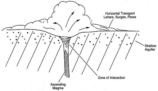
Fig. 2.37
When magma erupts through a shallow aquifer (dots), the aquifer is quickly depleted;
consequently, the eruption becomes dryer in character and forms monogenetic,
maar-tuff ring structures.
the aquifer, pressure in the conduit may fall below hydrostatic and water/magma interaction will begin. Proof of this hypothesis depends upon whether the aquifer water is really at hydrostatic pressure and whether the erupting gas-pyroclast mixture above the fragmentation level has a pressure gradient below hydrostatic.
Delaney (1982) demonstrated that when saturated rocks are heated by nearby magma, pore pressures increase sufficiently to drive hydrologic flow in the direction of least resistance (see Table 2.9). In cases where the magma is more permeable than the aquifer, the heated pore water might be forced into the magma. This hypothesis fits many observed tephra sequences in areas where information is available from drilling (Barberi, 1985; Barberi et al ., 1981). Barberi (1985) illustrated his model for deep water/magma interaction with a series of diagrams that
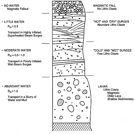
Fig. 2.38
This idealized depositional sequence for a shallow hydromagmatic eruption shows tephra
deposits of decreasing water abundance; such an eruption may end in solely magmatic
eruptions of pumice, scoria, or lava.
(Adapted from Barberi, 1985.)
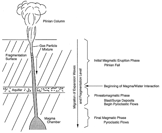
Fig. 2.39
In deep hydromagmatic eruptions, strong magma interaction with a deep aquifer begins after
the fragmentation surface recedes down the conduit to the depth of the aquifer. Decreased
gas pressure in the conduit above the fragmentation surface allows pore pressures in the aquifer
to drive water into the conduit. At right, the sequence of eruption styles is correlated with
the gradual migration of the fragmentation level (expansion waves) down the conduit.
(Adapted from Barberi, 1985.)
| ||||||||||||||||||||||||||||||||||||||||||||||||||||||||||||||||||||||||||||||||||||||||||
show the progression from a Plinian over-pressured eruption column (Kieffer, 1984a, 1984b) to a pressure-balanced eruption column to a Phreatoplinian eruption phase; during this process, the fragmentation level in the conduit has receded to the depth of the aquifer (Fig. 2.40).
Figure 2.41 illustrates the idealized tephra depositional sequence from a deep hydrovolcanic eruption. Initial tephra deposits are magmatic Plinian pumice falls that blanket topography. At the intermediate stage, the eruption enters its hydrovolcanic phase (Phreatoplinian), which is marked by surge and blast deposits filled with lithic fragments from the aquifer. The final stage is characterized by emplacement of pyroclastic flows that may show many features similar to those of wet surges (such as accretionary lapilli). It is possible for the pyroclastic flow stage to be marked by periods of dry and wet expulsions of tephra that feed the pyroclastic flows, so some parts of the deposit may show entirely dry products and others may show more influence of water/magma interaction. An example of such behavior can be interpreted from the pyroclastic flow and surge deposits of the Laacher See volcano in Germany. The repeated phreatomagmatic depositional cycles found by Fisher et al . (1983) within the pyroclastic ejecta at Laacher See are attributed to varying degrees of water/ magma interaction. The degree of water/ magma interaction in our present interpretation is a function of the fragmentation level depth in the conduit: when it fluctuates above and below an aquifer, eruptions cycle between wet and dry.
Pyroclastic rocks can be used to interpret the geometry of aquifer rock units at depth below a volcanic field, as is depicted in Fig. 2.42. In this hypothetical case, the aquifer rocks are a potential geothermal reservoir. A crescent-shaped caldera wall is exposed on one side. The caldera-forming pyroclastic flow shows two major facies: (a) a coarse-grained tuff with pumiceous and a few lithic fragments in the northern portions of the outflow sheet, and (b) a fine-grained lithic-rich phreatomagmatic (hydrovolcanic) tuff in the southern portions of the outflow sheet. Tuff ring and cone vents are found along part of the caldera wall and along fault trends that extend southeasterly out of the caldera. In addition, lava flow vents are evident outside the caldera in the outflow sheet. Using the distribution of hydrovolcanic products, it is possible to infer the geometry of a saturated basement rock unit. Apparently, the caldera erupted at the intersection of an east-west fault structure and a northwest-southeast-trending one. Ring vent eruptions to the north of the fault were dry and dispersed magmatic products northward; eruptions south of the fault must have involved water from the aquifer to produce hydrovolcanic eruptions that dispersed phreatomagmatic tephra southward. The limits of this saturated reservoir rock can be further constrained along the northwest fault trend between the smaller hydrovolcanic vents and those that extruded lavas. Examples of such interpretations from the Sabatini and Albani volcanic fields of Italy are described in the following section.
Summarizing hydrovolcanic eruption sequences and aquifer depths, Fig. 2.43 is a plot of the water:magma ratio as a function of median tephra grain size. Very fine grained tephra deposits are an earmark of hydrovolcanic activity; theoretical arguments supported by field observations have determined that the finest grain sizes correlate to water:magma rations near 1.0, which are best suited for development of economically significant hydrothermal systems. Further support for this argument is developed in the following sections, which discuss such features as country rock fractures and thermal regimes—information that can be derived from detailed analysis of the lithic fragments contained in tephra deposits.
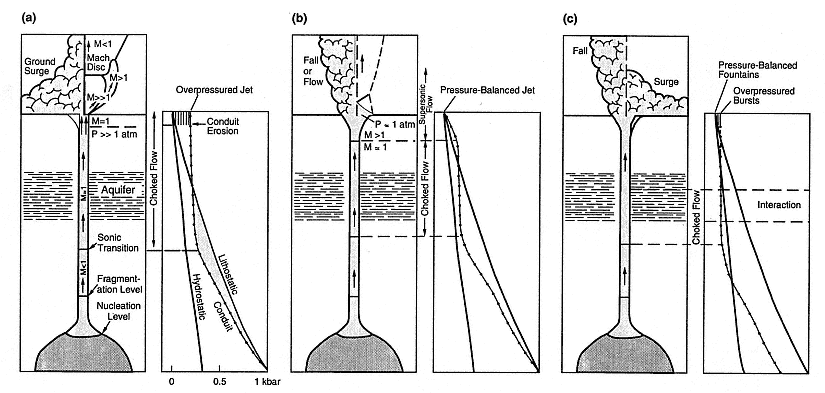
Fig. 2.40
Sequences of pressure gradients around the conduit for a Plinian eruption involving a deep aquifer. (a) Initial
eruptions are highly overpressured at the vent, causing blast conditions that involve both a
supersonic jet with a Mach disk structure (Kieffer, 1984b) and the eruption of ground surges.
(b) As the fragmentation level recedes down the conduit, the transition from a choked, sonic-speed flow
(M » 1) to one at supersonic speed (M > 1) occurs at depth, allowing eruption of a jet near atmospheric
pressure and development of a Plinian column that produces fallout deposits. For these first two eruption stages,
conduit pressure (dotted line) is greater than hydrostatic, which precludes the flow of much water from
the aquifer into the conduit. Wherever the conduit pressure is greater than lithostatic, conduit erosion will
add lithic fragments from that stratigraphic level to the erupted mixture. (c) When conduit pressure falls
below hydrostatic, water from the aquifer mixes with the magma to produce deep-seated hydrovolcanic
eruptions; abundant lithic fragments from the aquifer rock are emplaced in pyroclastic flows and surges from
a now-collapsing eruption column.
(Adapted from Barberi, 1985.)
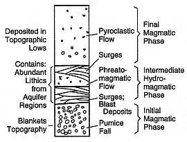
Fig. 2.41
Idealized stratigraphy of deep hydromagmatic
eruption products, showing transitions from
early magmatic eruption of pumice fallout to
intermediate stages of hydromagmatic eruptions
of surge blasts to dry or wet eruptions of
pyroclastic flows (with accretionary lapilli).
(Adapted from Barberi, 1985.)