12
The Hungry Ocean
When I have seen the hungry ocean gain Advantage on the kingdom of the shore, And the firm soil win of the wat'ry main, Increasing store with loss, and loss with store . . .
Shakespeare, Sonnet 64

Toward the end of the Victorian period, it was becoming apparent to those who cared to notice that the concentration of so much of the new recreation industry at coastal destinations was interfering with the self-correcting capacity of wind and wave. One kind of balance—among the various demands on the agricultural countryside—seemed to have been achieved by placing in jeopardy another balance, one that nature had established on the margins. Meanwhile, advances made in dredging technology and the construction industry were making it increasingly profitable to undermine beach sand and shingle. At a time when Britons were beginning to find their isolation from the rest of Europe less and less "splendid," some geographers and geologists among them were issuing warnings that the defenses around the "kingdom of the shore" were being undermined. Thus, on a number of levels, concern was growing about the integrity of the ramparts guarding the British Isles.
Earlier specialists on shoreline geography had been comforted by the thought that the forces of nature could usually be relied on to rebuild what they tore down. Writing in 1831, the noted geologist Henry De la Beche developed the theme that artificial interventions in the form of built barriers or pumps and dredges were not vital to winning this war of attrition: that there were natural restraints on the ocean's capacity to inflict damage on the solid earth. Where coastlines had ample supplies of sand
and shingle, he noted, the waves breaking on the shore tended to "pile up barriers against themselves." He explained that the crash of shingle-filled waves during a storm causes sand and pebbles to mound up just beyond the break line, creating a barricade against future onslaughts. Storm waves take sand out to sea, then calm waves slowly bring the sand back, thus restoring the normal beach slope and preparing the shore for the next onslaught.
De la Beche offered Chesil Bank on the Dorset coast as a particularly striking illustration of this "strategy" of advance and retreat. There, pounding waves had gradually raised a sixteen-mile-long shingle bank to a height, in places, of fifteen feet. Storm waves, loaded with small quartz pebbles, had also created Slapton Sands by crashing on the beach. This shingle bar, stretching some six miles along the Devon coast from Start Bay, had preserved the mouth of five valleys for centuries. Ferocious winds had broken through the sands in November of 1824 and filled a freshwater lagoon behind with brine. But then, De la Beche noted, the sea had immediately set about the task of repairing the beach, assisted on this occasion by a few bags of pebbles carted in by people who wished to preserve the lake fishery.[1]
Assured by the thought that the ocean itself was the best protection against its own destructive force, writers on agricultural matters directed public attention in the early and mid-Victorian years to projects aimed at reclaiming farmland from the sea. Not surprisingly, enthusiasm for such reclamation diminished when the fortunes of agriculture began to wane in the 1870s. Engineers then tended to concentrate attention on developing technology for safeguarding valuable resort property.
Essential to that task was an understanding of what takes place when an artificial barrier interferes with natural checks on coastal erosion. Knowledge about these matters had been accumulating,[2] although a leading authority on seacoast engineering at the turn of the century, W. H. Wheeler, commented in 1902 that in no branch of his profession "is there so little unanimity of opinion, or in which so much money is from time to time expended on works that are useless."[3] He found it puzzling that a sea-girt kingdom had contributed so little to the science of oceanography or to knowledge about processes of erosion and accretion, Dutch, Danish, German, and French specialists having made most of the advances in theory and practice. Furthermore, what had been learned about the action of wave, tide, and current had not, he believed, been communicated to those public authorities most directly concerned with coastal matters.
Wheeler had in mind the projects undertaken by seaside resorts to shield their frontages. His book The Sea-Coast is filled with instances where, in the "fight between the sea and the land," victory had gone, not to the resort promoters, but to the waves. The difficulty was that groynes (barriers reaching from high-tide line down to low waterline), piers, jet-ties, and walls tended to starve downwind beaches. As one contemporary put it, engineers employed to shore up a stretch of resort beach seemed willing "to rob Peter to pay Paul." Building a pier at Storeham had deprived Hove and Brighton of their shingle supplies, and Dover had suffered when Folkstone, "a principal delinquent," got its pier.[4] Nine feet of shingle had once protected the beach at Hove. Then the town built a seawall, and within a year severe scouring had removed the entire stock. Dredges had to be brought in to replace the supply and prevent the wall from collapsing. Concrete walls at Sandgate, Seaforth, and Poole produced the same effect. Bridlington's sea bulwarks endangered thirty-four miles of the already fragile Holderness coast. Digging and dredging shingle for cement aggravated erosion at Lyme Regis and cost the Essex town of Walton, between 1874 and 1906, fifty-six acres of land.
Evidence of this sort kept accumulating, so that by the turn of the century seaside residents had become aware that they were being asked to make some sacrifices for technological progress.[5] Commented a member of the British Association in 1885, "as respects groynes there is hardly a watering place on our Southern coast where they have not become a burning rexata quaestio of the day."[6]
But the most unfortunate results of engineering interventions were to be found, Wheeler thought, at Blackpool. There promoters had experimented with a variety of protective devices. Their first step was to construct a rough stone footing to keep the sea away from the cliffs. This led to a rapid denudation of shingle: when scouring deepened the water in front of the parapet, wave action grew stronger. Engineers responded by taking shingle from the beach to repair the wall and by digging the foundations lower; but they managed, in the process, to remove all material along the frontage down to the clay base. To make matters worse, in the mid-1840s railway builders were busy assisting the force of the waves by carting away loads of beach material to construct a line from Poulton to Blackpool.
The conclusion Wheeler wanted his readers to draw from this debacle was that intervention into the natural processes of denudation and accretion was bound to be risky and should only be undertaken to safeguard crucial natural barriers like Spurn Point at the mouth of the Humber or
to stabilize unprotected beaches in front of the new resorts where wave action might be ruinous. Always, he advised coastal engineers, be sure to factor in the inevitable, sometimes remote, environmental consequences.[7]
Wheeler's warnings coincided with a growing sense from the mid-1880s and through the period of international tension during and after the Boer War that "strife is always raging" along the edges of "our island home."[8] Journalists, politicians, and engineers expressed fears that the island itself might be shrinking, both physically and figuratively. They acknowledged that preventive measures had actually aided the enemy as often as not. It was time, they thought, for island residents to reconsider their situation. In earlier days Britons had been able to think of their coastline as "the enclosing walls of a garden";[9] perhaps it had become appropriate now to think of the seashore as a bastion under siege.
This apprehension became more widely felt when Germany began to challenge the Royal Navy's rule over the waves. In 1902 a Canadian-born journalist named Beckles Willson published a book called Lost England in which he warned that "Old Ocean" was advancing against the land. This advance, he thought, prefigured an erosion in the political and moral fabric of the nation. It seemed as though Neptune, once Britain's ally, was no longer willing to play that role, but had determined instead to sweep away "into the insatiable salt flood," the "green verge of the realm."[10] Overheated rhetoric of this sort was by no means rare. A sense of beleaguered isolation and physical vulnerability entered into nearly every form of discourse. Several years later, a magazine article entitled "Crumbling of the Coasts—Vanishing England" speculated in verse that by the time the Germans were ready to invade, they might discover that
The coast line had vanished, the cliffs with a crash
Had yielded to billows that bellow and bash;
And afloat far away where the whales wallow free
Was the last bit of Britain that fell in the sea.[11]
In 1904 an engineering journal made the point more soberly. It claimed that "in the perennial struggle between sea and land, the frontiers of England are being continuously pushed back" and called for the kind of national mobilization already under way in continental Europe.[12] Two years later, the Tribune in London warned that the sea was breaking down the coastline and "threatening to steal whole villages under the very eyes of the nation that boasts itself its ruler." The editorial concluded by urging that the national government follow the example of
France, Italy, and Belgium and take responsibility for defending the realm's frontiers.[13]
The government did respond, after a fashion, by setting up a royal commission in 1906 to investigate the rate and consequences of coastal erosion. Commissioners were influenced by talk about the island in danger and presumed at the outset that the war of attrition was being lost. Thus they were surprised and, at first, skeptical when presented with some confusingly compiled statistics suggesting that England and Wales had, between 1880 and 1905, actually experienced a net gain of about 30,000 acres.[14] The commission was not reassured by this information. Members thought that the figures were distorted by the fact that most of this gain was concentrated in the area of the Wash—the large tidal basin between Norfolk and Lincolnshire.
Elsewhere, as many witnesses before the commission testified, exploitation of shoreline resources seemed to be assisting the sea in undermining the shore. To a certain extent, that had always been the case. The farmers of Devon and Cornwall gained, as the result of a license granted in 1261, the right to take sand from beaches so long as they used it to improve tillage.[15] Beaches had long been mined to supply shingle for ship's ballast as well as to provide sand for agricultural purposes: to lighten and fertilize soils and to bed cattle. Demand increased significantly from the 1840s, when railway contractors sought material for track beds. When the rail network was completed, the needs of an expanding concrete industry for sand and gravel more than took up the slack.
Concrete had been available for centuries but was not widely used in Britain. Early in the nineteenth century, several experimenters, including a Leeds bricklayer, Joseph Aspdin, developed portland cement. This invention greatly expanded concrete's versatility. Ancient builders had discovered that cement would set in water if made from carbonated lime containing a high proportion of clay. But the difficulty of obtaining natural material with the right mixture tended to limit the use of concrete in constructing harbors and sea defenses. Portland cement, so named to suggest to builders that it produced concrete the color of portland stone, was a powder matrix made from lime, silica, and aluminum heated at a high temperature. This artificial product was cheaper to make than natural cement and was harder and dried much more quickly. In 1851 I. C. Johnson set up the first mill at Frindsbury to produce an improved version of portland cement made with chalk and Medway mud.[16] Some of his products were on display at the Crystal Palace Exhibition. Within
a decade or so, hydraulic concrete, a mixture of cement with sand and small stones or gravel, became an increasingly common substitute for brick and stone, particularly in massive dock works where utility was of greater importance than finish.[17]
Despite these improvements, the use of concrete did not become widespread until the 1860s at the earliest. Difficulty in manufacturing a product of standard quality seems to have been the inhibiting factor. Eventually, methods for testing quality before pouring were worked out but not until several decades after the portland cement industry had been established.[18] In 1881 Dr. Erdmenger, a German expert, contrasted the fast pace of the industry in his country with the slow progress in Britain and attributed the lag to the failure of British industrialists to employ men with scientific training in their cement works. He said that German technicians had worked out the exact chemistry of the ingredients and were thus able to adjust the mix to the requirements of a particular job while British manufacturers simply used their kilns to test quality.[19]
Nevertheless, use in Britain was sufficient by the 1880s to awaken the interest of administrators of Crown properties and those lords of manors who happened to have acquired proprietary rights to foreshores. Considerable profits could be gained from supplying materials to be mixed with hydraulic cement and used to make concrete for harbor jet-ties, seawalls, dockyard works, and groynes. From the 1860s what had been on many beaches almost for the taking turned into a valuable source of income—a clear illustration of how technological innovation can create property rights over resources once regarded as free or communal.[20]
Building contractors leased the mineral rights and brought in steam dredges. The consequences for the beaches and the shorelines soon became apparent. Experts on shoreline erosion sounded alarms: greed and economic development were threatening to remove the ground on which an island people stood. A spokesman for the British Association in 1885 emphasized that erosive processes had, like everything else, become more artificial than natural and blamed the precarious state of the southeast coast on the creation "of works of defence in a selfish spirit, unaccompanied by concerted action."[21]
The Royal Commission on Coast Erosion issued reports, along with testimony, in 1907, 1909, and 1911. They show how poorly the existing laws and rival agencies defended the shoreline. Asked by a commissioner whether he was aware that the removal of shingle from a beach might have effects higher up the coast or farther down, C. E. Howlett replied,
"No, I am afraid that is rather a new point to us." Howlett was the principal clerk to the Commissioners of Woods and Forests, and the "us" he referred to was his special branch, charged with protecting and exploiting Crown property along the shoreline.[22] His counterpart at the Board of Trade was aware that interference with beach materials or with their pattern of drift might have unexpected consequences but added that this awareness had really only percolated down to his department seven or eight years previously.[23]
On the same occasion, the head of the Survey Committee of the Board of Agriculture and Fisheries had great difficulty in explaining to a group of questioners the difference between a foreshore (the zone between high and low tides) and the beach area above the high-tide line.[24] It should be borne in mind, however, that testimony of this kind may reflect departmental tactics as much as ignorance, since Board of Trade officials had, with unfortunate consequences, granted a number of licenses to allow mining of building materials. Therefore they had reasons for appearing less well informed about coastline erosion than perhaps they actually were.
One instance of this danger particularly interested the commissioners in 1907. They heard a detailed story about how Sir John Jackson, a contractor, had received a license in 1896 from the Board of Trade (a body that advertised itself as the protector of the public interest in coastal matters)[25] to take shingle from a bar known as the Greenstraight in Start Bay, just offshore from the old Devon fishing village of Hallsands. It was a tiny hamlet, little changed over hundreds of years. Walter White described how, on his walk from London to Land's End in 1855, he came, late in the afternoon, to this lonely, wild-looking place where several dozen cottages stretched along recesses in the cliff above a shingle beach. In exchange for accounts of events in the Crimea, the proprietress of Hall-sands' tiny London Inn agreed to put four chairs together in the parlor; on that rude bed White had slept soundly, lulled by "the solemn plunge of the surge upon the beach, not forty feet from the window."[26]
It was this shingle, which absorbed the force of the wave and kept the inn safe, that Jackson proposed to mine. His intention was to use the material to make concrete for improvements at the Admiralty's Keyham Dockyards at Devonport on Plymouth Harbour. Having received permission from one arm of government, Jackson then negotiated a contract with the Commissioners of Woods and Forests, whose sole interest seems to have been to ensure that Crown properties brought in the best
possible return. Seemingly as an afterthought, commissioners did, however, include a clause requiring Jackson to refrain from doing any injury to the village of Hallsands.[27]
Steam dredging operations began in April 1897. Steam dredgers had been used, here and there, since the early years of the century. As early as 1805 a remarkable American inventor, Oliver Evans, constructed a seventeen-ton steam-propelled dredge called "Orukter Amphibolos," which trundled itself over land to the Schuylkill River in Pennsylvania and then, true to its name, turned into a stern-wheeler and paddled itself to Philadelphia.[28] Several decades later a Boulton and Watt engine attached to a windlass pulled a "spoon-and-bag" dredger along the bottom of the harbor at Sunderland, the first instance of steam-powered dredging in Britain.[29] But it was not until the last quarter of the century that sophisticated chain bucket, grapple, and suction devices capable of clawing, scooping, and sucking up huge quantities of sand, mud, and rock were employed on a large scale. (See Figure 12.)
At Hallsands, Jackson first used a bucket loader, probably of the St. Austell type, to fill barges and then brought in two suction dredges. The buckets on the first machine had more than twice the capacity of most dredges used in the 1870s; they could lift in a day what would previously have taken nearly a week. The suction dredges were even more efficient, being able to fill between them thirty-four barges in ten days. Waiting until high tide, these powerful devices moved in and stripped shingle in front of the Hallsands beach from the top down. By 1901 Jackson's company was barging away 22,000 tons a week.
Over the next four years machines scooped up 650,000 tons of shingle, lowering by fifteen feet in some place the shore in front of the steep cliff with its rock platform and nestling cottages. One hundred and fifty feet of beach above the high-water mark disappeared, carted off to be made into an artificial product and used in a place far from its origin. The rapidity of this process testifies to the devastating effect of advanced steam technology on a coastal landscape. The champions of the land in the contest against the sea had developed a potent new weapon, but, as the Hallsands example demonstrated, one that could turn against the land's defenders. "The beach went to Keyham," wrote Richard Hansford Worth, a Devonshire geologist, "and the houses to the sea."[30]
Within the first two months fishermen discovered that the wide, dry beach where they pulled up their boats was fast disappearing. Their protests brought a visit from a Board of Trade inspector who decided that the alarm was exaggerated and ruled against the fishermen. Over the
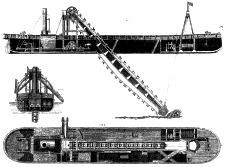
Figure 12.
Bucket-and-ladder dredging machine (1867). Constructed to cut a submerged
sandbar, this dredge and others like it could also mine beaches—thus weakening
natural defenses and assisting the ocean's erosive power. (Engineering 4, 1867)
next three years, waves reached and undermined the low seawall protecting the village. Jackson paid some compensation and put in a concrete wall; but, because there was no longer a protective beach, the result was to increase the scouring effect of the waves and to cut the ground and rock out from under the concrete.[31]
A second formal complaint brought a second inspector. At the hearing, Jackson's agent claimed that damage was due solely to natural forces. This caused one of the sufferers to remark that if such were the case, "nature has been extremely well assisted."[32] The Board of Trade this time agreed that the complainants had a case and placed restrictions on the dredging operation. In January 1902 the board decided to cancel the license, although Jackson seems to have assumed that he could still carry away sand and did so for two more years.
The dredging of shingle stopped in 1902, but the damage was already done. Wave energy, which had previously dissipated as it pushed across the gradual slope of the shingle, now struck the rock bench with full
force. When there were gales, the buildings received a buffeting as well. In September of 1903 the kitchen, beer cellar, and a bedroom of the London Inn collapsed. Finally in 1917 an easterly gale gave Hallsands its coup de grâce. As two modern historical geographers have commented, its ruins "stand out as a reminder of man's folly in interfering with the natural setting of the coast."[33]
At the time, questions were asked in the press and in Parliament about why this reckless treatment of a sensitive environment had been allowed, especially since tests previously carried out by the Marine Biological Association suggested that the shingle had been deposited in much earlier geological time and was not being renewed—a conclusion Worth confirmed in a series of articles first appearing in 1904.[34] Much was said about the greed of private exploiters and the feebleness and ignorance of all levels of government, but few practical remedies were brought forward.
The North Wales seaside town of Rhyl offered another example of what Worth called "the consequence of theft." John Ellis, of Rhyl's Urban Council, described how a dredging company in the late 1870s leased the gravel deposits at the mouth of the Clwyd River from the owner of its riparian rights and took two million tons of gravel to make concrete for Liverpool's Mersey Docks. The result was that some of the supply was cut off from Rhyl's beaches. This weakened the sand spit that kept high-tide waters from inundating low-lying ground inland—including, eventually, the town's golf links.
To meet this threat to the beaches, the council paid the Commissioners of Woods and Forests, who acted as agents for the Crown—the titular owner of the foreshore, a license fee to construct groynes. These devices acted to retain the sand and shingle in front of the town but did nothing to protect the shore outside town limits. Ellis thought it patently unfair that the action of one arm of the government—the Board of Trade—should force the ratepayers of Rhyl to pay protection money to another arm—Woods and Forests—particularly since those ratepayers, after having submitted to this injustice, still found their collective livelihoods threatened. The golf links were one of the resort's major attractions. Some 25,000 summer visitors arrived annually and needed to be entertained.[35]
This statistic provides a clue to why so many coastal places began investing heavily in sea defenses from the 1870s on. Sand, shingle, and gravel were being mined from beaches to improve harbors and to make walls and groynes, partly because so many towns were responding to an
expanding demand for seaside holiday facilities. Investors in those facilities called for safeguards. Paradoxically, the more the protectors removed material to build groynes and seawalls, the more protection the beaches required. As fishing villages and minor ports turned into seaside resorts, they expanded to include vulnerable stretches of shoreline previously allowed to shrink or enlarge as nature dictated. Engineers then were called in to extend the protective system. Doing so often had an adverse effect on neighboring shorelines, so more expensive protective devices were called for.
At Herne Bay, one of the places along England's coastline most affected by erosion, local officials felt themselves trapped in this seemingly endless cycle. So frustrated was Harold Ramsey, a town councillor, that he formed in 1906 the National Sea Defence Association to enlist the aid of other towns in lobbying the central government for financial assistance. Representatives from thirty-five seaside councils met in Westminster to support Ramsey and to give accounts of their efforts to secure their beaches. They complained about the unfairness of placing the burden of securing the nation's shorelines upon local ratepayers and doing so at a time when a shrinking island was supporting more and more people. T. H. Baker from Clacton-on-Sea spoke of the wholesale removal of beach material and estimated that the town, at the end of the day, had paid out £10,000 for every £100 worth of shingle carted away. Martin Cheverton-Brown of the Withernsea Urban Council warned that his town was in imminent danger of being "outflanked" by the sea. He also argued that it was entirely just to require that taxpayers from large cities pay for the protection of the "lung" resorts they repaired to in such large numbers during the holiday season.[36]
As spokesman for the Sea Defence Association, Ramsey was asked to appear before the Royal Commission on Coast Erosion. His testimony gives us a feeling for how spongy the administrative marshlands must have been. Asked about changes over the last fifty or sixty years, he gave a brief account of how a bare stretch of beach had become a seaside resort, catering to a middle-class clientele. In 1907 Herne Bay had a wintertime population of 8,500, but in the warm months the influx caused it to swell to hold 40,000. This pattern of dramatic seasonal ebb and flow had only established itself, Ramsey said, over the last fifteen years or so and had completely changed, in that short time, the town's looks and character. As the town expanded, so did concern about the fragile foreshore.[37]
Erosion had always been heavy along this part of the Kentish coast.
The cliffs were made up of loamy soil on a substrata of London clay. Not only were banks prone to slip toward the sea, but they broke down in wet weather and exposed soft debris to wave action. In 1894 a developer's tract collapsed before he had paid all of his installments. The court decided that he must continue to pay since it had been common knowledge that the cliffs were unstable when he made the purchase.[38] This was a sensible decision. Residents were all aware that their foundations were anything but firm. Records kept at Herne Bay between 1872 and 1896 showed a loss of about a thousand feet of land. North and east winds caused the beaches of the area to "travel." Before development engulfed the older core of the town, the constant coastal downdrift seems to have caused no great concern.
That changed when boarding houses and summer cottages began to appear on exposed places at either end of the beach. Speculators, buyers, everyone interested in promoting resort facilities, urged local authorities to secure these considerable investments. A sympathetic Urban District Council worked out an elaborate and expensive protective system: a series of groynes to intercept longshore drifting and hold beaches fast, a fence made of woven faggots parallel to the shore, a massive concrete breakwater at the western boundary, a strong "breastworks" at the east end, and conversion of an old oyster pier into a groyne to check the movement of the beach. At first, all seemed to go well: these measures worked as they were intended, and the areas under council control remained stable. The difficulty was that sand and shingle soon began piling up on one side of the groyne and the pier, causing severe scouring on the other side and weakening the capacity of these structures to resist battering from severe storms.[39]
But the major threat came from just outside the town's jurisdiction. Rural councils on the flanks saw no reason to ask ratepayers to finance expensive sea defenses that would benefit speculative developers from the town. Speculative developers had no wish to saddle themselves With huge expenditures, preferring instead to pass on to prospective customers the cost of securing building sites. On the western side the situation was, from the town's point of view, much worse than on the east. Interfering with lateral drift in front of the town meant that the soft cliffs would not renew those shingle beaches and sandbars that provided the cliffs with natural protection. To make matters worse, the Commissioners of Woods and Forests and officials at the Board of Trade behaved as they had done at Hallsands and Rhyl and, ignoring protests, permitted
concrete manufacturers to remove quantities of sandstone from low-lying stretches of foreshore.
Everyone had someone else to blame for depriving Herne Bay of its original crescent shape, thus creating, over the years, a "misnomer." One member of the Royal Commission, however, went close to the heart of the matter when he asked Joseph Jubb, solicitor to the Herne Bay Council, this leading question: "Then it is your own prosperity that has really aggravated the problem?" Jubb had to admit that by protecting its eastern flank and safeguarding it for development, the town had injured the land farther west.[40] On the other hand, as his colleague, Councillor Ramsey, pointed out, once the process of building sea defenses began on any large stretch of coastline, resorts were obliged to respond or risk economic or even physical oblivion. Towns were only allowed to tax those who owned or leased buildings. Landowners, including those who profited by selling their beach resources, could not be forced or prevailed upon to contribute to the cost of protecting the shoreline. Ramsey reminded the commissioners that the Belgian government had recognized the domino effect of large-scale protective efforts and the responsibility for assisting with costs. He implied that if Belgium's central government was willing to spend a million pounds a year for these purposes, then Whitehall could at least consider granting subsidies to local authorities, guaranteeing loans, and providing experts to make sure that dilemmas like the one his town faced did not keep arising.[41]
In only one instance in the nineteenth century had the government departed from its laissez-faire policy: at Spurn Point on the end of a long, thin sand-and-shingle spit at the northern entrance to the Humber estuary. Being really the coming together of the Trent and the Ouse, two rivers that drain fenlands, the Humber carries a heavier burden of silt than any other river in England. Since Stuart times, land reclaimers had "warped up" the tidal marsh land by digging earthen banks, allowing spring tides to flood in, and then closing sluice gates. When the sediment had a chance to settle, the water was then allowed to escape, leaving behind up to three feet of rich mud. In three years the soil would have dried out sufficiently and lost enough of its salt content to allow for the planting of rape seed, then oats, beans, potatoes, and other root crops. On the northern shore of the estuary, Sunk Island grew in this way from an area of about nine acres to become, by 1911, part of a reclaimed area extending over more than 7,000 acres.[42] For this large expanse of man-made land, Spurn Point and its long beach acted as a "natural" groyne. Ebb tides
scoured the navigable channel near the point and flood tides brought in additional shingle and sediment from the erosion of the Holderness coast to the north. The result was a fortunate balance of dynamic elements, to which human artifice contributed.[43]
Thus it was with alarm that the Admiralty learned in 1849 that individuals were removing shingle from the narrow spit at the rate of 60,000 tons annually. That year a storm forced a breach that threatened to undermine the already weakened natural barrier.[44] Arguing that to preserve the Humber as a harbor of refuge was in the national interest, a Captain Vetch laid out a plan for building fifteen groynes, the government to pay one half of the costs and those lords of the manor who would benefit, to pay the other. The Admiralty agreed to put up £10,000, and the work commenced. In 1852 the contractors asked for a further £5,000 to £6,000. The Admiralty Lords agreed, providing that Trinity House, the seaman's guild in charge of lighthouses, supervise construction and maintenance. Eleven years later, all appropriations spent and little accomplished, the government ordered the Board of Trade to take charge. This time the work was carried to a successful conclusion. Even so, an official from the Board of Trade admitted before the Royal Commission in 1907 that this success in preserving Spurn Point and its lighthouse had "starved" the coastline farther north.[45]
The lesson the Board of Trade seems to have drawn from this experience was that powers and jurisdictions were so hopelessly confused that it would be best not to encourage further direct interventions. A solicitor to the board was asked what his department might do if it discovered that a groyne it had licensed interfered with a beach farther down. He replied that, since an individual had the right to protect his property, "the effect further down does not arise"—not, one would have thought, a particularly forceful conception of the board's stated determination to protect the national interest.[46] The fact that no legislation aimed at establishing a national coastline policy appeared until the Town and Country Planning Act of 1947 shows that politicians were in no hurry about urging civil servants to more aggressive efforts.
There was a positive side to this otherwise depressing story of Victorian and Edwardian greed, apathy, myopia, confusion, and bureaucratic bumbledom. Alarm at the possibility that economic development, assisted by rapid advances in technology, might be literally undermining the British Isles at their edges did drive home to many the fact that humans, for a long time critical elements in coastline ecology, had now become the main morphological determinants.[47] Even people who had no
interest or background in geological or geographic issues were coming to realize that the coastline landscape was, like all other landscapes, ceasing to be in any sense natural. This realization served to alert groups and individuals to the need for conservation and preservation.[48]
A refrain in the testimony heard by members of the Royal Commission on Coast Erosion was that nature had once worked out its own way to deal with attacks from the sea but was no longer being allowed to do so. They heard from experts that, if left alone, erosion prevented erosion in the sense that the crumbling cliffs fed debris to starving beaches, debris that absorbed some of the sea's power to erode. Thus, as one writer on coastlines noted, the sea "fortified the land against its own powerful incursions."[49] Clement Reid advised the British Association that "we should strike a balance between loss and gain before we attempt to stop erosion." [50] Accounts from Hallsands, Rhyl, Herne Bay, and many other places around the edges of England, Wales, Ireland, and, to a lesser extent, Scotland brought home those points in graphic detail.
At the same time, those who paid attention to the Royal Commission hearings were reminded that the time had long gone when the shore's protection might be left to natural forces. William Whitaker, a past president of the Geological Society, an expert on coastal geomorphology who had spent thirty-nine years on the Geological Survey, tried to impress on his hearers that, over the course of the last hundred years, human interventions had converted a natural coastline system into an artificial one. To speak about a natural coastline was like referring to the natural process of the Thames—forgetting that this water course, like all the other so-called rivers of the land, had long ago become a canal. This meant, said Whitaker, that rivers "do not do what nature would let them; they have to do what we allow them." Similarly, "our coast is artificially treated to a very large extent."[51] Thus he tried to impress on his listeners that to talk about "sea erosion" confused the issue, since much of the erosion was caused not by the sea but by industrial enterprises; by disruptions of natural drainage systems brought on by deforestation, cultivation, ditching, excavating, and paving; and by the action of farmers in plowing or allowing animals to graze near cliffs. He thought the great effort at constructing barriers against wave action during the last century, although uncoordinated and piecemeal, had made the concept of "natural seacoast" a contradiction in terms.
However, Whitaker offered no comfort to those who might conclude that, having made much of the coast into an artifact, they might as well go ahead and "put a cast-iron band all way around." To do that,
Whitaker cautioned, would only increase the force of the waves and eventually weaken the fortress walls.[52] His counsel was to abandon the notion of "absolute protection" and to concentrate scientific knowledge and engineering experience on strategic defenses for vital harbors and town frontages, leaving the rest alone. He thought it crucial that farmers be encouraged to leave strips along cliff sides uncultivated in order to preserve the long-established natural herbage. He would prohibit the dumping over cliffs of mining and quarrying debris, rubbish, and industrial wastes and only allow beach materials to be removed where experts had done studies of sediment sources and flow patterns to determine possible consequences. How these worthy guidelines were to be implemented he did not venture to say; but at least he managed, along with others, to articulate the dangers of continued virtually unrestricted development and to suggest a set of remedies that still constitute much of the modern conservation program.
What to do about the damage already inflicted was a question that also concerned individual Victorians and led some of them to experiment with reclamation projects. The person and project most often referred to in 1907 were the earl of Leicester and his experiments on the coastline of Norfolk. Probably it was Sir Henry Rider Haggard who made sure that Lord Leicester's plantation of the Wells sand hills got as much publicity as possible. The author, who gained fame by writing the robust schoolboy classic King Solomon's Mines , was chosen to sit on the Royal Commission on Coast Erosion on the strength of his two-volume work about the condition of agriculture. In Rural England Haggard had described a visit he made to the earl's Holkham estate, where he inspected progress being made in planting a variety of pines to help fix the shifting dunes of the estate's ocean frontage. He made sure that passages describing his visit were included in the appendix to the commission's report.[53]
Haggard was impressed by the fact that trees, planted in sand and shingle, had provided an environment where lichens, then marram grass and St. John's wort, had been able to establish themselves. These plants had generated sufficient soil to allow the pines to reseed. As a result, the 300 acres of plantation had become self-sustaining. Having held up this experiment as a model, he must have been disconcerted when Lord Leicester's agent, J. M. Wood, testified at the commission hearings that the plantations had little to do with safeguarding the beach; that they inhibited growth of the marram grass that did fix the dunes; that they offered
little prospect of becoming commercially viable, and that they had proved to be a costly, although amusing and attractive, hobby.[54]
The earl of Leicester was only one in a long line of aristocratic coastline reclamationists. As in the case of experiments in planting on industrial and mining wasteland, it had been landlords—Lord Palmerston was one of them—who had made the first attempts to win back dunes and marshes from the sea.[55] Some did so as a speculative venture, but usually the motive was to improve the appearance of estates. Others, like the proprietors adjoining the Culbin Sands, struggled to save properties from encroachments.
No region offered a greater challenge to reclaimers than this long expanse of blowing, shifting sand stretching northwest along the south coast of Scotland's Moray Firth from the Highland town of Nairn and Findhorn Bay. According to a seventeenth century map, the village or barony of Culbin (or Cowbin ) stood on a peninsula in the middle of the coastal area until a great storm in 1694 blew most of it away. The reason a once-productive estate had crumbled so quickly was that generations of gatherers had removed the marram grass that grew wild on the dunes and used it for thatching and for weaving baskets and mats—or so the Scottish Parliament assumed when it subsequently passed an act prohibiting the harvesting of plants whose roots anchored coastal sands.[56]
For the next 230 years, most of Culbin remained a constantly shifting waste; but, on the inner edge of its eastern side, a Mr. Grant of Kincorth decided in 1839 to plant pines and several varieties of deciduous trees to shelter his house from the blowing grit. Shortly afterward, a neighbor on Findhorn Bay began planting marram to fix the dunes and prepare for tree planting.
These attempts proving successful, other plantations were made on the Dalvey estate near the village of Kintessack, on the Brodie estate near Bankhead, and on the Moy estate near the river Findham. During the Second World War, the trees that grew on these estates, being sufficiently dense and healthy, were harvested; but, as H. L. Edlin points out, it was obvious by the time the Forestry Commission began acquiring them (between 1921 and 1956) that uncoordinated efforts by a handful of landlords could never hold back the constantly building and drifting mass.[57]
Eventually the commission did manage to turn Culbin Sands into Culbin Forest—one of Britain's most important reclamation projects. This feat seems to have been beyond Victorian or Edwardian will and perhaps capacity. Even so, the nineteenth century did make contributions
to reclamation technology. The most significant was the possibility of applying discoveries made by botanists and biologists. Among the first to do so was Lord Montagu of Beaulieu, whose training as a steam engineer and passion for internal combustion engines made him, like the third duke of Sutherland, an uncommon aristocrat. He described to the Royal Commission how his experiments with imported rice grass, which spread and propagated under water, had made dry land out of the mud flats of Southampton Water. On reading reports of this testimony, J. M. Wood, the Holkham agent, asked to be sent a hamper of the grass and set about planting the species along the muddy sections of the estate coastline.[58] Thus, in the decade before the guns of August sounded in 1914, there were signs that some subjects of the kingdom of the shore might be working out peaceful and "natural" reclamation methods.
But in 1949, hostilities intensified between the two rivals on the edge of Southampton Water. Esso decided to expand its refinery site at Fawley, partly on land reclaimed from the nearby salt marsh. Soon the new supertankers began bringing in Near East crude. These huge ships needed room to maneuver. Facilities had to be constructed nearby to store the quantities of off-loaded oil, and later, as the fashion for enormous carriers spread, to store chemicals, ores, coal, and grain. Industries and power stations gathered nearby to use or process what was being imported and stockpiled. So dredges set to work bringing up muck from harbor floors and depositing it along the soft estuary shores. Wetlands retreated at Southampton and at other harbors as ports around the world were expanded or created specifically to serve the new transport technology. This "gigantism" prevailed on the coastline until the mid-1970s, when Britain and other advanced industrial countries began scaling down heavy industry and when environmental damage reports began reaching the public through the media.[59]
What is left of Britain's coastal wetland, its "last commons," now seems reasonably safe from that line of assault. But new technologies aimed at harnessing or controlling tidal energy along with continuing recreational demands on coastlines make it probable that any truce will be fragile.[60] In the meantime, environmentally conscious people search for less bellicose language to describe border tensions between land and sea and labor to convince policy makers that firm soil does not necessarily "win" when it manages to wrest store from the wat'ry main.