Sea Arches and Stacks at Point La Jolla
Erosion of the bluffs at Point La Jolla pose an interesting problem. Examination of the formations and their concretions at the west end of the bluffs and a comparison of their present condition with photographs taken in about 1900 show a conspicuous lack of appreciable erosion (figs. 81a , 81b ). One arch at Goldfish Point has shown very little change since 1908 (figs. 71a , 71b ). The
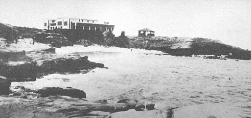
Figure 81a
Photo of La Jolla Cove, 1906. Two buildings were then located on the bluffs behind the cove. The
sandy beach is a favorite swimming spot.
Photo: Anonymous.
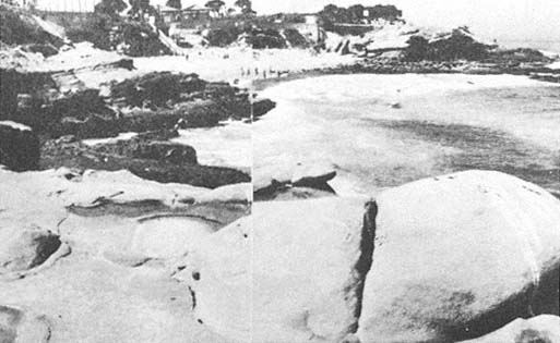
Figure 81b
April 1968 photo of the same site as that in 81 a . Note that the sandstone rocks in the foreground
show almost no change in sixty-two years, but the 1906 buildings have been replaced, and the
cove area is now a city park.
Photo: F. Shepard.
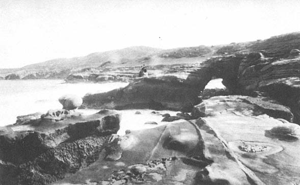
Figure 82a
View of Alligator Head arch, 1870. Note that many lineations and concretions are clearly identifiable in both
this and the following photo.
Photo: F. Shepard collection.
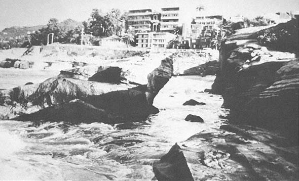
Figure 82b
View at the same location as that in 82 a , 1978. Collapse of the arch occurred during a storm in January 1978.
Photo: G. Kuhn.
same is true of some massive boulders of concretionary appearance a little to the west near La Jolla Cove, which apparently are on the edge of a rock terrace exposed to large converging waves formed by Alligator Head. Furthermore, old pictures of the cove west of the cliffs show decided changes in the well-known arches which existed in the early part of the century and which were partially reinforced with cement in later years. They finally collapsed, the last one falling in 1978. The outer part of Alligator Head has also changed since early photographs were taken around 1870 (fig. 82a ). This arch also collapsed in 1978 (Shepard and Kuhn 1983) (fig. 82b ).
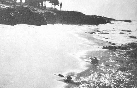
Figure 83a
Boomer Beach west of La Jolla Cove, sometime in the 1940s. Seasonal change occurs
as the result of the different direction of wave approach and the heavier winter surf.
This photo shows summer conditions; waves from the south have built a beach at the
north end and have taken sand away from the south end.
Photo: F. Shepard.
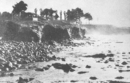
Figure 83b
The same location as that in 83a , taken sometime in the 1940s. This view shows the winter
conditions when heavy surf from the northwest has removed the beach shown in 83 a and
carried sand to the south, creating another, smaller beach on the right in the photo.
Photo : F. Shepard.
Boomer Beach, just south of Alligator Head, is interesting to watch for seasonal changes. It consists of a coarse sand beach with a steep frontal slope during summer months (fig. 83a ) but, with the first winter storm, the sand is washed away to expose underlying boulders (fig. 83b ). The sand apparently is carried partly to the south, forming narrow beach fringes, and some is carried seaward. However, with the onset of summer and the south-approaching waves, the sand returns to Boomer Beach, and the narrow fringes to the south disappear.
Most of the relatively straight, rocky coast extending toward the Children's Pool had had little erosion since the 1930s until the storms in January through March 1983 caused many large cracks to develop. At the Children's Pool, also known as Casa Pool, there is a jetty built out from a rocky point, partly enclosing a cove. It was thought that by putting large holes in the south end of the jetty, any sand that was carried into the enclosure could be washed through, keeping the pool open. This did not work, however; the holes soon became blocked, and the pool was filled with sand, leaving at the north end only a narrow semicircle of water. Farther south, there was a rocky point with some breaks in its continuity
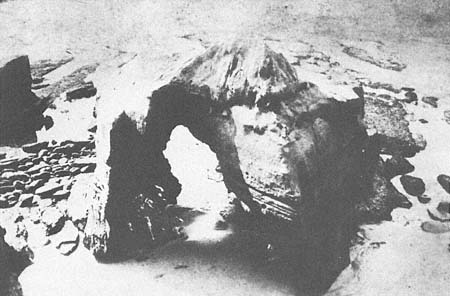
Figure 84a
View of Cathedral Rock Arch, La Jolla, 1873.
Photo: F. Shepard collection.
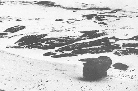
Figure 84b
October 1963 view of the same site as that in 84 a . A remnant is all that is left of the
buttress at Cathedral Rock. By 1968 this remnant had also disappeared.
Photo: F. Shepard.
and a beautiful arch called Cathedral Rock on its west side (fig. 84a ). The arch collapsed in 1906 and, when Shepard first photographed the site in 1934, the buttresses of the old arch were still standing, as were other rocks that have since gradually disappeared; now every remnant of the arch is gone (fig. 84b ). Many sections of the partially submerged rock point have been removed as well, so that the entire coast south of the Children's Pool has changed extensively since the first photographs were taken of this area.
Still farther south is Windansea Beach where body surfers find excellent wave conditions for riding the surf. We have some photographs dating back to 1934 which show some interesting changes. There was a natural bridge, apparently cut in a surge channel and exposed only when the sand was cut away
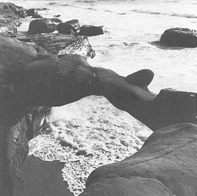
Figure 85a
View of arch at Windansea Beach, La Jolla, 1952.
Photo: F. Shepard.
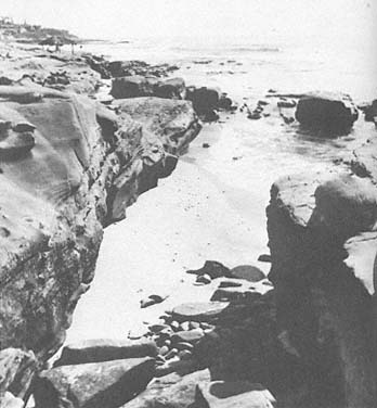
Figure 85b
Summer view after Windansea arch collapsed, 1968.
Photo: F. Shepard.
from the sandstone during winter storms (fig. 85a ). This arch collapsed sometime in the 1950s (fig. 85b ). It is interesting that the sand shifts to the south during the winter months and to the north during the summer, as at Boomer Beach. Again, there is more sand during the relatively small waves of summer. Sea cliff retreat was observed by lifeguards one-half mile south of Windansea Beach during January 1983. Other parts of this rocky coast that have not been studied are probably also retreating. It is known, however, that erosion was occurring at the foot of Marine Street just before Christmas of 1940 during a period of large waves. The small bluff in front of the Revelle house near Windansea Beach was being eaten away by these waves when Shepard and Revelle returned from a cruise to the Gulf of California on December 23 of that year. Erosion was halted by dumping large boulders at this point; a seawall later was constructed by the Revelles. This was the same storm that cut away the talus at the base of the cliffs that terminate north of La Jolla (Kuhn and Shepard 1979a ). One wonders what conditions of the early 1900s allowed the development of sea arches in these resistant rock units. Only one arch is being formed at present, so far as we know, and all the old ones have disappeared (Shepard and Kuhn 1983).
South of La Jolla the cliffs and terraces are of much softer rock, and beyond the Bird Rock area they are largely alluvium. One house there had a porch extending out to the edge of a shale cliff, but in 1965 the porch collapsed when the underlying cliff failed. At Bird Rock, a stack standing above the tidal terrace showed little erosion during the past few decades, up until January 1963, as documented through photographs. The low alluvial cliffs, however, are actively eroding, although the rate has not been established.
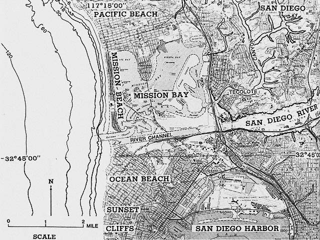
Figure 86
Location map of Pacific Beach, Mission Beach, and San Diego Bay and River.