Explorers' Observations at Sea
Let us now leave the general history of navigation and consider some examples specifically connected with exploration. The importance of Captain Cook's three voyages in

Figure 5.5.
Performance of timekeepers on Cook's third voyage.
the history of science was largely the result of scientific bodies such as the Royal Society and the Board of Longitude being allowed to take an active part in the planning, execution, and analysis of the voyages, giving a model on which to base the scientific organization of so many future voyages, both British and foreign. These were the first British voyages to carry trained astronomers, naturalists, and artists to observe and record what they saw. The astronomers were provided with the best instruments that money could buy, many of which, being public property, were used again in subsequent voyages by Vancouver, Flinders, and others. A few still survive.
The scientific results of these voyages were published by the Board of Longitude, and it is from these that I shall take most of my examples.[6] Let us first look at the observations made at sea. Every day at noon, weather permitting, meridian altitudes of the sun would be observed with the sextant to find latitude. We know that in Cook's ships several officers would do this together, both as training for the officers and to increase precision. A similar ritual has survived in many ships to modern times. Among the secondary aims of Cook's last two voyages was to try out the newfangled longitude timekeepers. At sea, a longitude-by-watch observation would be taken morning and afternoon if there were no clouds.
Now let us turn to lunar-distance observations—or "lunars" as they were familiarly called. One of the most practical features of the new almanac was a table giving predicted lunar distances from the sun and zodiacal stars every three hours throughout the year, a feature suggested by Lacaille to cut down the arithmetical work done by navigators (Figure 5.6). And so it proved: the time taken to work out a sight and obtain a longitude was cut from over four hours to an hour or so.
Now to the navigator's procedure. Essentially he needed to measure the angular distance between the moon and (in the case of Figure 5.7) a star. But it is also necessary to

Figure 5.6.
Lunar-distance tables from The Nautical Almanac and Astronomical
Ephemeris for the year 1772. Published by order of the Commissioners
of Longitude (London, 1770). The quantities in Figure 5.3 come from
this table. (Reproduced courtesy of the National Maritime Museum, London.)

Figure 5.7.
Lunar-distance observations showing the three near-simultaneous
observations required to find longitude by lunar distance: (1) the
angular distance between the moon and a selected star (or the sun);
(2) the altitude of the moon above the horizon; and (3) the altitude
of the star or sun above the horizon.
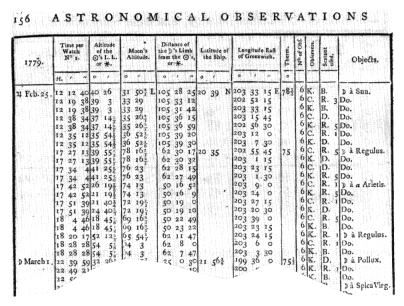
Figure 5.8.
Lunar-distance observations taken on board the Resolution off the
Hawaiian Islands a week or so after the death of Cook. The penultimate
columns indicate the observers (C = Clerke, who took command of the
Resolution after Cook's death; K = Lieutenant James King, who ultimately
took command of the expedition after Clerke's death some months later)
and the sextants used (the makers being B = John Bird, D = Peter Dollond,
R = Jesse Ramsden). From the published astronomical observations,
Cooke, King, and Bayly, Original Astronomical Observations,
p. 156. (Reproduced courtesy of the Bancroft Library.)
measure the altitudes of the two bodies as nearly simultaneously as possible in order to correct for parallax and refraction. The lunar distances predicted in the almanac assume the observer is at the center of the earth. In fact the observer is some feet above the earth's surface, and, furthermore, both bodies appear too high because of atmospheric refraction, the amounts depending upon their respective altitudes—the lower the altitude, the more the refraction. Both these effects had to be allowed for; indeed, "clearing the distance," as it was called, was the most

Figure 5.9.
Meteorological observations in the Discovery. Cook was murdered
on 14 February 1779. From Cooke, King, and Bayly, Original Astronomical
Observations, p. 332. (Reproduced courtesy of the Bancroft Library.)
laborious part of the whole computation.[7] If the sun or star was more than two hours from the meridian, then the altitude found at the same time as the lunar distance could be used to obtain local time—our symbolic sundial time. Otherwise, it was necessary to wait for the body to be on a suitable bearing, the time difference from the lunar observation being noted from a watch with a second hand. Figure 5.8 shows the results of a series of lunar observations on Cook's third voyage.
Other observations taken at sea included those for magnetic variation with an azimuth compass; meteorological observations with barometers and thermometers (Figure 5.9)—a primitive form of anemometer or wind gauge was taken but was not a great success; and the salinity of seawater with water sampler bottles and a hydrostatic balance (Figure 5.10).
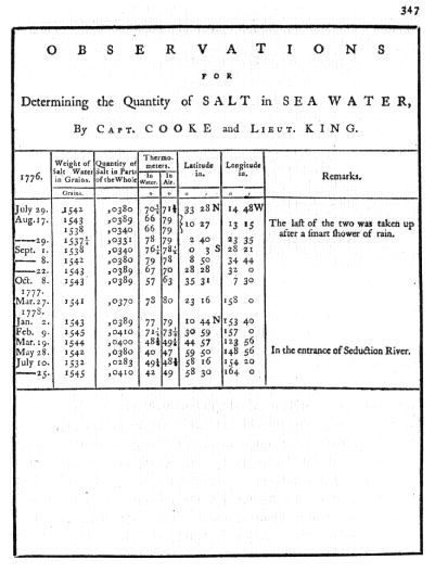
Figure 5.10.
Salinity observations on board the Resolution. Those
in 1776 were made in the Atlantic when on passage from
Plymouth to the Cape of Good Hope, that in 1777 in the South
Pacific, those in 1778 in the North Pacific. From Cooke, King,
and Bayly, Original Astronomical Observations, p. 347. (Reproduced
courtesy of the Bancroft Library.)

Figure 5.11.
Diagram of the transit of Venus.