Navigation: The Early Years
At the beginning of the eighteenth century, navigation was dominated by what the navigators themselves called "the three L's"—the lead , for measuring the depth of water; latitude , which was comparatively easy to find by measuring the sun's height above the horizon or that of the Pole Star;
and lookout , the need for which is self-evident. To these ought, perhaps, to be added one more L and two C's—the log , for measuring the ship's speed through the water; the compass to steer by and to take bearings with; and the chart to show where one has come from and where one is going, as well as the dangers on the way.
The state of the art at that time is conveniently summarized on the title page of John Seller's Practical Navigation of 1669 (Figure 5.1), which shows two navigators of the time with the tools of their trade—a cross staff to find latitude by observations of Polaris; two versions of the back-staff to find latitude by observations of the sun at noon; an azimuth compass for finding magnetic variation, generally by bearings of the sun near sunrise or sunset; a steering compass ; a nocturnal for finding the time by night; a portable universal equinoctial sundial for finding the time by day; a simple wooden quadrant for measuring altitudes; and, of course, a book of charts . There is no lead or log here, but Figure 5.2 shows a navigator of about eighty years later with a Hadley quadrant for latitude—of which more anon—and an English log and a compass at his feet. It shows also his logboard, the second and third columns giving the hourly log reading in knots and fathoms.
We have mentioned finding latitude, time, and magnetic variation, but not, you will notice, finding longitude—be-cause at that time it could not be done at sea. From the time he saw his last land—his departure fix—until he made a landfall, the navigator had to keep track of his progress by "dead reckoning," that is, by making the best estimate of his course and speed made good over the ground, hour by hour, watch by watch, day by day. He would take into account the courses steered by compass, the speeds measured by log, the magnetic variation, the leeway, the currents (tidal and otherwise), and add to these his own experience as to how the ship's course and speed were affected by wind and sea. At noon every day, he would work out his "day's run" from these data, resolve that into its north-south and east-west components, and

Figure 5.1.
Title page of John Seller's Practical Navigation [1669]. The navigator
on the left is holding a cross staff, the navigator on the right a backstaff,
with another version on the table beside him. Azimuth compasses
are on the table left center and center, steering compass right; nocturnal
hanging left, portable equinoctial sundial hanging right with quadrant
above; atlas of sea charts (Seller's own English Pilot) on table center
bottom. (Reproduced courtesy of National Maritime Museum, London.)
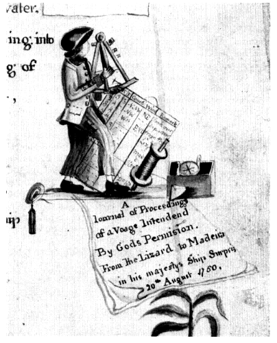
Figure 5.2.
A master's mate observing with a Hadley quadrant. On the ground,
left to right, lead and line, log reel with line leading to log ship, and
azimuth compass. The log board has the standard headings:
H[our]; K[nots]; F[athoms]; Course; Wind; Remark[s]. From the title
page of the manuscript "A book of Drafts and Remarks . . . by
Archibald Hamilton, late master's mate, of his majesty's ship St Ann.
1763" (NMM Ms NVP/11). (Reproduced courtesy of the National
Maritime Museum, London.)
compute his daily noon position in latitude and longitude. If the weather was clear at the critical moment of noon, he could check his dead-reckoning latitude—his "latitude by account"—against his latitude by meridian altitude. But it was not possible to check the longitude in the same way and, as such errors are cumulative, after a long ocean voyage the dead-reckoning longitude might be many hundreds of miles in error, sometimes with disastrous results.
These restrictions imposed a navigating strategy known as "running down the latitude" which can best be explained by taking a real-life example. On 5 November 1681, the buccaneer ship Trinity sailed for the West Indies from southern Chile, missed the entrance of the Strait of Magellan, rounded Cape Horn at a distance of some 250 miles (reaching a latitude of 58°23' south), and sailed up the center of the South Atlantic until the latitude of Barbados (13°10' north) was reached on 18 January 1682. Then she turned west, keeping in the same latitude. Ten days later, an hour before daybreak on the morning of 28 January—nearly three months and 9,000 miles after leaving Chile—they sighted the island of Barbados on the port bow at a distance of two and a half leagues.[1] A quite remarkable feat of navigation which proved that the strategy really worked!